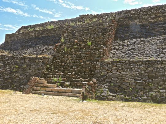
Monday, March 14, 2022

Peralta Part 3 of 3: The Ancient People

Teotihuacán-style mask found in a burial at Peralta. Stone masks like this are closely associated with the Teotihuacán empire (100-650 AD). The history of that empire overlapped the first three hundred years of Peralta's history (300-900 AD). Trade between the two was extensive and this led to cultural exchanges, including the use of stone masks in burials.

In this third and final part of my Peralta series, we'll take a look at artifacts from the site's museum that illuminate various aspects of the life of Peralta's ancient inhabitants. These will include objects of daily life, trade practices, burial practices, and how the city came to be abandoned. To locate Peralta, see Part 1.

Overview

The author, perusing a display at Museo de Peralta. The museum is located near the site's parking lot. It is here that you pay the modest $39 peso ($1.86 USD) fee prior to visiting the ruins. The display above explains some of the history and culture of El Bajio (The Lowland). 

El Bajio is the region between Querétaro and Jalisco from east to west, and from the mountains of Guanajuato in the north to those of Michoacan in the south. During the Classic and Epi-Classic periods (100-900 AD), the region was thickly settled. It contained a number of substantial cities, including Peralta with its 10,000 inhabitants. 


Artifacts of daily life

Ceramic items like this were used to prepare and serve food. The plate demonstrates the high level of artistry of pre-hispanic potters. Cultivated plants provided food staples such as maiz (corn), beans, squash, chiles and amaranth. Together, these provided a remarkably balanced and healthy diet.

Maiz was so important to pre-hispanic societies that it appears prominently in many creation myths. From it, the ancient people made tortillas, tamales, gruel, and a drink called atole. Only a handful of animals were domesticated for food, including turkeys and dogs. People supplemented their diets with wild plants, as well as game animals such as deer, rabbits, birds, and insects. 


A bowl with an unusual base caught my eye. I have not seen a bowl set on a base like this at any other ancient site I have visited. Most of the pottery and other artifacts in the displays were recovered from tombs or burial sites. Ceramics like this left on the surface stood little chance of surviving over the millennia. This makes the discovery of intact tombs an especially important source of information about ancient cultures.

Grave robbing is the bane of archeology. Often, robbers will smash pottery to see if valuables are stored inside. Even when stolen items are intact, they will have lost the context in which they were recovered. Cultural information can be inferred from the positions of objects in relation to one another. The level soil in which they were discovered can reveal time frames. Looting destroys all this. 
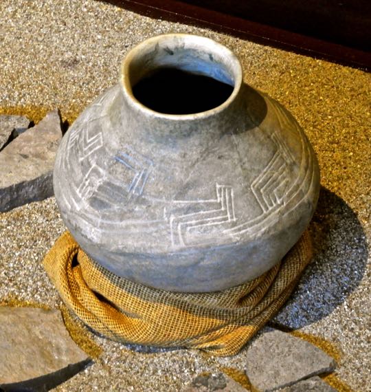

Pots were sometimes etched with abstract designs. Ceramics were decorated in a variety of ways that included etching of designs like this or painting with human or animal scenes. Pots like this might be created for domestic use or for local or long-distance trade. Ceramics might also be brought in from elsewhere as trade items. There is much more pottery on displayed at the museum than I have space to show here.


Whistles were used during dance performances and rituals. These were carved from bone, but others were crafted from wood or clay. Wind instruments like whistles were sometimes used in rituals associated with the Wind God Ehecatl, one of the most important deities worshipped at Peralta. A large Circular Structure devoted to Ehecatl was found within the Recinto de los Gobernantes (Enclosure of the Governors). See Part 1 for more details.

In addition to religious rituals, whistles were used by hunters to mimic animal noises and by warriors to terrify enemies with shrieking sounds. Curanderos (healers) used them to induce a dream-state in order to treat certain illnesses. They were also employed in death rituals related to human sacrifice. Although modern scientists are able to produce sounds using these ancient instruments, they don't really know what the music played on them sounded like.


Tobacco was smoked in bone pipesThe pipes above show that tobacco was definitely used at Peralta. In fact, the use of tobacco in the Americas goes back at least 12,300 years. Pre-hispanic people used tobacco for religious rites, as medicine for earaches and toothaches, as a trade good, for ceremonial gifts, and sometimes as a medium of exchange.


Obsidian arrow heads have been found in various sizes. Obsidian can be crafted into a wide variety of tools and weapons, including arrowheads. The edge of this volcanic glass can be sharper than modern surgical steel. The arrowheads above were likely used for hunting. The smallest would have been for birds and other small animals, while the larger ones were for deer, peccary, or other large game. The tip of the one on the lower right is broken off, possibly from hitting bone.

Trade and trade routes

Porters were used to haul a variety of trade goods. The painting above is a detail from the work of an indigenous artist shortly after the Spanish arrived. The lack of pack animals in pre-hispanic times meant that human porters usually carried trade goods. Interestingly, some of the porters above are approaching boats, possibly to utilize water transport. The Rio Lerma passes near Peralta and is navigable by small boats on much of its 750km (450mi) length. 

Mesoamerican trade routes stretched from New Mexico to Honduras and reached both the Pacific Coast and the Caribbean. One region where many of them crossed was El Bajio. The merchants who organized the caravans had their own god, whose painted image decorates the walls of the Epi-Classic city of Cacaxtla (near Puebla), a contemporary of Peralta. While it was well-nourished by its fields of maiz, beans, and squash, trade made  Peralta rich.


Obsidian cores and tools. A core is a chunk of raw obsidian. By carefully striking it, large flakes can be removed. Further striking can then transform the flakes into various sharp-edged instruments. Millennia of practice enabled ancient people to fairly quickly produce tools and weapons or to replace those that were lost or broken.

The obsidian trade was as important to pre-hispanic societies as the oil trade is for modern countries. A significant source of the volcanic glass has been found near present-day Penjamo, only about 33km (20mi) from Peralta. Scientific analysis of an obsidian tool found in Texas showed that the volcanic glass from which it was crafted may have come from Penjamo, demonstrating the extent of the pre-hispanic trade networks. 


Painted bowls were traded widely in Mesoamerica. Although ceramics are both weighty and fragile, they were also a major trade item. In fact, archeologists have long used pottery and potsherds as markers to understand trade between different city-states. Whole systems have been developed for naming different cultural phases according to pottery styles and for tracing the influence of one culture on another.

Bowls like the one above would have been considered luxury goods. With careful packing and handling, they would have been worth risking on a long trek. Elites shopping in the markets in distant city-states practiced conspicuous consumption, just as modern people do. Assuming the breakage was not significant, traveling merchants could make a healthy profit on their pottery.

Burial rituals

Human remains and grave goods recovered from an elite burial. The tomb was discovered within the Recinto de los Gobernantes. This gravesite was one of most important discoveries at Peralta because of the quantity and diversity of objects recovered. These included decorated pots, necklaces, wooden items, and knives and projectile points made from obsidian.

In some Mesoamerican societies, artificial cranial deformation was practiced. Elite families would bind the skulls of their infant children with wood and leather. This was done to elongate the skull so that, as an adult, the person would appear different from commoners. However, the adult skull in this burial shows no sign of elongation. This suggests that the practice was not followed by Peralta's elites. 


Large urn recovered from a tomb.  The style of the urn indicates that it was created as a grave good, rather than for practical use. This is a very old tradition in pre-hispanic western Mexico and is frequently found in El Bajio tombs. The damage on the side of the urn may have come from a partial collapse of the tomb. 

Urns were sometimes used for what archeologists call "secondary burials". Sometime after the original burial, bones would be collected and reburied elsewhere, often within a pot like this. The purposes and meanings of pre-hispanic secondary burials are not well understood and may have varied from society to society, as well as over time.


Teotihuacán masks were not meant to be worn by the living. They are too heavy and lack carved-out backsides to fit a human face. They were death offerings, meant to be placed in a shrine or tomb. Teotihuacan masks are easily recognizable because of their similarity. They are genderless, with wide-open eyes and mouths and a straight nose. Now empty, the eyeholes once contained white shells and black onyx to imitate eyes and the mouth had teeth made of bone. 

I have seen scores of masks like this at sites all over Mexico. Their close similarity suggested to me that they were not the creations of individual craftsmen but mass produced. In fact, recent scientific investigation shows that Teotihuacan manufactured them on a large scale, but at a site far from the capital city. Production occurred in the state of Puebla, possibly at the ancient city of Cholula. 

The end of Peralta: drought, invasion, or both?

Chicomoztoc appears in many Mesoamerican migration myths. During the last part of the 10th century, waves of fierce nomads from the northern deserts began to migrate south. Some tribes passed through El Bajio, seeking to escape a decades-long drought. Collectively, these Nahuatl-speakers were known as Chichimeca ("barbarians"). When they arrived in El Bajio, the drought had already caused crop failures and famines. It was at this time--around 900 AD--that cities like Peralta were abandoned. 

Chicomoztoc ("Place of the Seven Caves") appears in the origin myths of several Chichimeca tribes. The drawing above is from a 1550 AD depiction by one tribesman. In the myths, Chicomoztoc is usually described as a mountain containing a multi-chambered cave. It was the origin point, or at least a stop-over, on a great migration. In the tribesman's drawing, each of the chambers contains a different tribe. In some versions, the tribes departed separately over time. 

The Mexica (Aztec) version is the most famous. Even after they had won an empire, they still glorified their Chichimeca origins in the last great pre-hispanic wave of migrants. However, the myth may date back at least 600 years prior to the Mexica. In fact, each of the three great pyramids of Teotihuacán represents a mountain and each has a man-made cave beneath it. Some even have multiple chambers. The location of Chicomoztoc, if it actually exists, remains a mystery.


Chichimeca warriors attack a pre-hispanic city. Like Peralta, this city sits on a hilltop, surrounded by a wall similar to that of the Recinto de los Gobernantes. Also like Peralta, the hillside is covered with cactus and maguey plants. Winding around to the left of the hill is a river which could very well have been the Lerma, which passes near Peralta. Defenders stand behind the wall, fending off attacks from all directions. 

On the hillsides, some of the Chichimeca warriors aim obsidian-tipped arrows at the defenders. Others wave weapons called macuahuitls. These flat, wooden swords had edges filled by razor-sharp obsidian blades. In their other hands, the warriors hold up circular shields. This painting was created by an indigenous artist after the Spanish arrival, but is probably an accurate portrayal of pre-hispanic warfare at the time of the Chichimeca invasion of El Bajio.


Human skull, shortly after it was unearthed. What happened to Peralta's inhabitants? Were they massacred and their city razed? There is clear evidence of such destruction at about the same time at other Epi-Classic cities such as La Quemada ("The Burned Place"). The Spanish gave its ruins that name because the great conflagration that destroyed the city was still evident after 600 years. 

The defensive hilltop position and strong walls of the Recinto de los Gobernantes showed that its builders anticipated such attacks and may have experienced some. To date, archeologists have not unearthed evidence of destruction at Peralta similar to what had happened at La Quemada. However, news of the fates of La Quemada and other Epi-Classic cities such as Xochicalco, Cantona, and Cacaxtla would have spread rapidly across Mesoamerica. 

Such frightening news, combined with economic collapse caused by drought and the disruption of the Epi-Classic trade networks, may have resulted in a panicked flight to safer locales. One of those places could have been the rising Toltec state at Tula, in today's Hidalgo state. Lacking written records, we just don't know. What we do know is that El Bajio was depopulated within a few decades. Except for scattered bands of nomads, it remained empty for the next 600 years.

This ends Part 3 of my Peralta series and completes the series itself. I hope you enjoyed it. If so, please leave any thoughts or questions in the Comments section below. If you do leave a question, please be sure to include your email address so that I may respond in a timely manner.

Hasta luego, Jim


Saturday, March 5, 2022

Peralta Part 2 of 3: The Sunken Patios and the Double Temple Complex

My friend Vinnie, on a pyramid staircase. The staircase ascends the largest of the two pyramid-temples of the Double Temple Complex, which is part of the ruins of the ancient city of Peralta. The city is located in the region of Guanajuato known as El Bajio (The Lowlands). Vinnie and I traveled there in February of 2022 on a photographic expedition.

In this part of my Peralta series, I will first show several of the features located to the west of the Recinto de los Gobernantes (The Governors' Enclosure). We'll then move on to the Double Temple Complex. For those who might want to visit Peralta, see the directions in Part 1.

Overview:

Google satellite view of the Peralta ruins. North is toward the top of the photo. Two sunken patios stand to the west of the Recinto. Sunken Patio #2 is the square to the left of the Circular Structure visible in the photo above. Sunken Patio #1 is located to the south of #2, near the southwest corner of the Recinto.

The Double Temple Complex is about 30m (100yds) to the northwest of the Recinto. It is composed of two pyramid-temples that form two of the sides of another sunken patio. The pyramid on the east side of the patio is the largest. A smaller pyramid on the south side adjoins it at the south east corner of the sunken patio. Sunken patios and plazas are one of the characteristic features of the architecture found in El Bajio's ancient cities. (Photo from Google satellite view)

The Recinto's west wall and the Sunken Patios

The Recinto's west wall, viewed from its southwest corner. Sunken Patio #1 is to the left of the Nopal cactus. At this point the wall is about 3m (10ft) high and extends 137m (450ft) to the north. The Recinto de los Gobernantes is the largest structure of its kind found in any of the ancient cities of El Bajio


The Recinto and Sunken Patio stairs. A three-step staircase in the foreground leads down into Sunken Patio #2, from which this shot was taken. The main staircase originally rose to the top of the Recinto's west side and gave access to the Circular Structure, the Ceremonial Pool, and the elite residences (see Part 1). 

The restoration workers who rebuilt this staircase chose not to complete it to the top, possibly to discourage climbers. Presently, the only access to the interior of the Recinto is on the south side. The platform was built on sloping ground, so that the wall is higher in some sections than others. At this point it stands about 7m (20ft) tall. 


Sunken Patio #1 viewed from its northwest corner. The Recinto's west wall can be seen in the background. Sunken Patio #1 is approximately 1m (3.3ft) deep and is roughly 7m (20ft) on a side. The most important features of the Recinto are located on top of, or attached to, its west side wall. This includes the main staircase. The two Sunken Patios probably were probably used by the high priest and other elites for preliminary ceremonies prior to their ascent of the staircase. 


Sunken Patio #2 is larger and shallower than its counterpart. While it is at least 20m (60ft) on a side, it is only about 2/3m (2ft) deep. In this shot you can clearly see the relationship between the patio and the main staircase of the Recinto. The sole staircase leading into and out of Patio 2 is directly below the west wall's staircase.


Indigenous dancers. While this is a modern person, his attire would have been familiar to the performers who danced in Peralta's sunken plazas and patios 1400 years ago. Like him, they would have been festooned with bright feathers and armed with rattles made of seed pods filled with small stones. Some dancers, like one of those behind this man, would have worn ankle rattles made from similar seed pods. (Photo from the Tres Reyes Fiesta of Cajititlán, Jalisco). 

It is easy to imagine Peralta's ancient dancers twirling and stamping the ground, making a rhythmic sound with their rattles. Drums carved from hollow logs would have boomed, while the eerie, mournful tones of conch shell trumpets would have filled the air.  Bone flutes and wooden whistles would have added their shrill sounds. All these kinds of instruments have been unearthed in ancient burial sites all over Mexcio. 


The Double Temple Complex

The Double Temple Complex, looking south. The larger stepped-pyramid on the east (left) has six levels and may have originally had more. Its sole staircase is on its west side, leading down into the Sunken Patio below. The smaller pyramid on the south side has three stepped levels. A ruined structure on top may have once formed a fourth level. Its only staircase also ends in the patio, but is wider than that of the east side pyramid. (Aerial photo from Wikipedia).

The outside dimensions of the Double Temple Complex measure 85m (279ft) from east to west and 79m (259ft) from north to south. The top of the east side pyramid, which is the highest point in the complex, rises to 12m (39ft). Although the Double Temple Complex is smaller than the Recinto de los Gobernantes, it is every bit as intriguing. Its function appears to be entirely religious/ceremonial. No traces have been found of any dwellings within the complex.


The author, approaching the south side of the Double Temple Complex. At the point where the two pyramids adjoin, a staircase leads up to a small platform from which the sunken patio can be viewed. My previous experience at this site taught me that the best photos here would be achieved from a height, rather than from ground level. (Photo by Vinnie Heptig)


View of the stepped levels of the south side of the eastern pyramid. After carefully picking my way up, my effort was rewarded. Visible to the east are the beautifully reconstructed stepped-levels of the larger pyramid's south face. In ancient times, these walls would have been covered by brightly-painted plaster. 


The front of the smaller pyramid faces north, into the sunken patio. Turning left (west), I could see the smaller pyramid's first three levels, along with its staircase. This structure seemed more crudely constructed than its counterpart, indicating that it may have been built at an earlier time. While the south and east sides of the patio are bordered by the two pyramids, the west and north sides are enclosed by stone walls.


View to the north, along the west side of the larger pyramid. The perimeter wall on the north side of the sunken patio can be seen in the distance. This pyramid's only staircase can be seen about half way along the length of the wall. In order to explore the Double Temple Complex from here, I had to make a choice. 

I could descend another set of rough stairs below where I stood down into the patio. Alternatively, I could walk along the narrow ledge across the face of this pyramid to its stairs. The ledge was only about 0.25m (10in) wide, but it looked solid and reasonably safe, assuming I stepped carefully. Vinnie, who had come up from behind, watched my progress and decided the rough stairs to the patio looked safer. 


Descending the east pyramid's staircase. After traversing the ledge in the upper right, I began to descend. Although the lower part of the staircase was well-restored, the section I was climbing down in this photo was still pretty rough. Fortunately, I could use my hiking pole to balance myself and to test the stability of the rocks.

Vinnie was standing in the small platform I had just left when he took this shot of me. I wondered at the time if he was secretly hoping to capture a spectacular tumble. He congratulated me when I reached the bottom, but I thought I detected of trace of disappointment. (Photo by Vinnie Heptig)


View of the sunken patio and pyramids from the west wall. The Circular structure within the Recinto de los Gobernantes (see Part 1) was clearly built to worship Ehecatl, the Wind God. However, it is not clear which gods were being honored when these two pyramids were built. What is clear is that the Double Pyramid Complex is oriented to the Cardinal Directions.  

A high priest who ascended the west-facing pyramid would be facing east, toward the sacred direction of sunrise when he reached the top. In addition, the tops of both pyramids would have provided excellent views of dances and other ceremonies performed in the patio below. They would also have made good speaking platforms to address the people assembled below. (Photo by Vinnie Heptig)


Artist's conception of a ceremonial dance. The view here is from the southwest corner of the patio, near the place where I originally ascended. As mentioned before, the stepped levels of the pyramids and the walls of the sunken patio were once covered by plaster and painted with designs. (Photo from Peralta Museum display)


The staircase of the larger pyramid shows several phases of construction. The lower stairs are the most recent. Previous stages can be seen as you ascend, with the oldest section near the top. In ancient times, new structures were built over top of previous ones. New rulers often sought to make a statement about their power through architectural upgrades.


The architectural influence of Teotihuacán can be seen here. The talud y tablero (slope and tablet) style can be seen along the front of the pyramid. Peralta was settled approximately 300 AD, during the height of Teotihuacán's power (100-650 AD). This is one of many indications of the cultural and economic exchanges between that great empire and the cities of El Bajio


The south pyramid, viewed from the ledge on the east pyramid's face. From here, you can see three levels of the south pyramid and some rubble from a fourth. Also visible are more talud y tablero features on its second level. The rough staircase by which Vinnie descended to the patio can be seen on the left. The rubble on the top of the pyramid was probably once a temple.


Staircase of the south pyramid. Only the bottom two steps have been fully restored. Peralta and the other cities of El Bajio reached their apogee between 700-800 AD. This was during the Epi-Classic era, following the fall of Teotihuacán and early in the rise of the Toltec empire (700-1100 AD).


The north side of the Double Temple Complex. This side of the eastern pyramid shows five of its six remaining levels. The sunken patio of the Double Temple Complex and those found elsewhere in Peralta are among more than 200 examples of this feature that have been found throughout El Bajio. This has led some archeologists to dub the civilization that created these architectural features "the sunken patio culture".

Peralta was in decline by the late 10th century, due to deforestation and overpopulation. A study of tree rings shows that between 897 and 922 AD a great drought parched north and central Mexico, causing major famines and economic disruption. Even worse, it forced the fierce nomads of the northern deserts to migrate south and Peralta was in their path. By 900 AD, the city was deserted. Except for scattered bands of nomads, the region remained empty for the next 600 years.

This completes Part 2 of my three-part series on Peralta. In the next part, I will show you some of the fascinating artifacts left by the people who once lived here. I hope you enjoyed Part 2. If so, please leave any thoughts or questions in the Comments section below, or email me directly. If you leave a question in the Comments section, please include your email address so that I may reply in a timely way.

Hasta luego, Jim

Saturday, February 26, 2022

Peralta Part 1 of 3: A unique archeological site in the Bajio Region

The author, viewing the Ceremonial Pool. This feature of the Recinto de Los Gobernantes (Enclosure of the Governors) is part of the Peralta Archeological Zone. Sunken patios like this are typical of the ancient architecture of El Bajio region. My blog fans may recall that last September I posted about a 2016 trip to Plazuelas, another of El Bajio's archeological sites. Unfortunately, a hard drive crash caused the loss of all of the Peralta photos that I had taken on that same trip. 

Recently, I decided to organize another expedition to the Peralta site in order to photograph it again. My neighbor Vinnie is a highly experienced photographer and he agreed to come along. This would be my first time venturing outside of the Lake Chapala area since the pandemic began, except for a journey last Fall to the US border for a booster shot. Hopefully, the success of this trip will make it the precursor for others.

The unusual features of the Recinto de Los Gobernantes will be the focus of Part 1 of this series. In Part 2, I will show you the Sunken Patios, and the Double Temple Complex. Part 3 will cover the ancient residents of Peralta and the artifacts they left behind. Because of Vinnie, this three-part blog series contains some shots of me, which is unusual because I am nearly always the person behind the lens. (Photo by Vince Heptig)


Overview

How to get there. Peralta is in the state of Guanajuato, about a 3 hour+ drive to the east of Lake Chapala. It is definitely near the limit of a day trip, unless you are a road warrior like me. Since the  Plazuelas site is not far from Peralta, it would be possible to see both on an overnight trip (Plazuelas is near the town of Penjamo). There appear to be a number of comfortable and inexpensive hotels in Abasolo, a town half way between the two sites, so an overnight stop seems feasible. Click here for an interactive Google map. 

The route is as follows: take the Chapala-Guadalajara Carretera to the Ocotlán-La Barca exit. Just beyond Ocotlán, get on the 15d cuota (toll road) toward Mexico-Morelia. After you pass La Barca, exit at Yuricuaro-Vista Hermosa. Shortly after the exit's toll booth, make a U-turn at the sign for Mexico-Morelia-Zamora. This puts you on Highway 110 toward Yuricuaro. Up to here, the route has been nearly all high-speed, 4-lane divided roads. Highway 110 is two-lane and thick with slow-moving trucks, so be patient until you get to the outskirts of La Piedad.

Shortly before reaching La Piedad, exit toward Irapuato onto the 90d cuota, merging eventually with 90 Libre, another 4-lane, high-speed road. Follow that about 60km (37mi) to Abasolo. About 15km (9mi) past Abasolo on the 90, take a right at the sign for Pueblo Nuevo. After several kilometers you come to a fork where you bear right at a sign for Hunimaro V de Santiago. After about 5km, you will come to the turnoff for San Jose de Peralta. Turn right as you enter the pueblo and follow that street 1km to the archeological site. 


Map of the eastern part of El Bajio, showing archeological sites. All the yellow dots are archeological sites. The white names and dots are modern towns. This map is a detail of a much larger one showing even more sites. El Bajio (The Lowland) extends from Queretaro in the east to Jalisco in the west and from the mountains of Guanajuato in the north to those of Michaocan in the south. (Photo from a display in the Peralta museum)

Between 300-900 AD, the region was heavily settled. During the Epi-Classic era (600-900 AD), El Bajio civilization reached its height. Villages and towns were everywhere, especially in the low, fertile areas along watercourses like the Lerma river and around the various shallow lakes. Several cities had large populations. Peralta, for example had 10,000 residents. Major trade routes passed through El Bajio from New Mexico to Honduras and from both coasts. 

All this has been discovered only recently. Although locals knew of the ruins, archeologists did not investigate until the 1970s, and major studies only occurred in the 2000s. Previously, El Bajio was thought to be an area without archeological interest. In fact, from 900 AD all the way through the Aztec era, only scattered bands of hunter-gatherers had occupied it. Until the Spanish settled El Bajio in the 17th century, the region had been considered a wasteland. 


The Peralta ruins and the modern pueblo for which they are named. The view here is toward the east. The site's two major parts are the Recinto de Los Gobernantes (right foreground) and the Double Temple Complex (left foreground). These structures sit near the crest of a low hill mounded with volcanic rocks and boulders. The area around the ruins is overgrown with mesquite and cactus. 

Beyond the hill, the terrain is generally flat, making it suitable for agriculture in ancient times, as well as today. To the east of the modern town is the blue Rio Lerma, which provided the water that made the ancient city possible. The governing elites lived in dwellings within the Recinto or immediately around it, while the commoners would have lived in the flat areas near their fields. (Photo from Peralta Museum collection)


Recinto de los Gobernantes

The northeast corner of the Recinto, looking west. The archeological site is open Tuesday through Sunday from 10AM to 6PM. After paying our $39 peso fee ($1.92 USD) at the site's museum, we proceeded up the walkway to the ruins. This finely-built wall was the first point we encountered. Peralta's ancient architects had no metal tools, only those made of stone, bone, or wood. They also lacked both draft animals and the wheel. Their only source of power was human muscle.

In spite of those limitations, they cleared and leveled a large area on the hilltop and then built a huge platform. It measures 147m (482ft) from east to west and 137m (450ft) from north to south and is the largest in the region. The beautifully-surfaced walls stand at a 45 degree angle and rise to a height of at least 4.6m (15ft) in some areas. The Recinto would have provided a good defensive position during the Epi-Classic era, a time of intense warfare between city-states.


The South Entrance provides access to the Recinto's interior. The remains of another entrance are on the west side. However, the west side's great staircase no longer reaches the top of the wall, so the South Entrance provides the only access today. Notice the thickness of the wall and the narrowness of the passage, Hostile warriors assaulting through here would have had to pass through single file, making them easy targets for the defenders.


Interior of the south wall, looking west. A large Pitayo cactus stands on the wall at its southeast corner. The low interior wall is less than 1m (3.3ft) high in most areas. To the right of this wall, and extending its full length, is a level corridor that is about 10m (33ft) wide. The interior edge of this corridor borders the Sunken Plaza. 

This corridor, and similar ones on the north and east, provided space for spectators to view dances and ceremonies occurring in the sunken plaza. The west side of the Recinto contains the Ceremonial Pool, Circular Structure and an area for elite dwellings. The Recinto de los Gobernantes has a sophisticated hydraulic system designed by the ancient architects to drain off water during the rainy season.


View of the Sunken Plaza from its northeast corner. Sunken plazas and patios are a characteristic architectural feature of El Bajio's cities. Examples have been found in 174 sites throughout the region. Recently, scientists discovered that these sunken features were designed to amplify acoustics during public performances. I will discuss this a bit later.

The interior edges of the corridors on the north, east, and south sides can be seen above. The Sunken Plaza is about 0.6m (2ft) below the corridors which border it. The plaza's extraordinary size would have provided enough space for masses of brightly feathered dancers. They would have cavorted to the sounds of drums, conch shell trumpets, bone flutes, and whistles. 

The curved wall extending into the Sunken Plaza from the middle of its west side is part of the large Circular Structure. It provided the stage for the ancient musicians and for spectacular rituals performed to honor Ehecatl, the Wind God. In addition the Circular Structure provided a platform from which the ruler or high priest could address a crowd gathered in the Sunken Plaza and the surrounding corridors. 


View to the west from the top of the west wall. The panoramic view above includes the green fields surrounding the archeological site and one of the many extinct volcanoes found in this part of the country. Volcanic debris provided building materials, as well as obsidian (volcanic glass) from which tools, weapons, and jewelry could be crafted for local use or trade.

Entwined together in the foreground are two varieties of cactus found throughout Western Mexico. These are the long-armed Pitayo and the flat-paddled Nopal. Both provide sweet fruits which were gathered by the ancient people. The Mexican landscape is full of wild plants like this that can be eaten or used for a wide variety of purposes. Many, including the Pitayo and Nopal, are still used today.
 

The Circular Structure

Aerial view of the platform's northwest corner and the Circular Structure. Evidence of dwellings for the ruler, high priests, and other officials have been found in the broad, flat area to the left of the Circular Structure. To the right of the Circular Structure is the Ceremonial Pool seen in the first photo. With a diameter of 42m (138ft), the Circular Structure provided a large space for musical performances, ceremonies, and speeches.

Mid-way along the outside of the west wall behind the Circular Structure is a large staircase. The ruler and other elites would have used this to access the structures on top of the Recinto's west side, including their dwellings, the Circular Structure and the Ceremonial Pool. Lesser mortals would have entered through the South Gate.

Several high-status human burials have been found on the Recinto's west side. The grave goods included valuable items such as jewelry made from turquoise, jade, and shells, as well as ceramic vessels. Many of these artifacts indicate long-distance trade connections with locations as far afield as New Mexico, the Pacific and Caribbean Coasts, and Guatemala. (Photo from Peralta's museum)


The west wall's Circular Structure faces east, toward sunrise. Most monumental structures in ancient Mesoamerica are square or rectangular and nearly all of these--including the Recinto de los Gobernantes--are aligned to the four Cardinal Directions. Each direction was considered sacred and was associated with a particular god. East was particularly holy because sunrise symbolized the daily rebirth of the world. Thus, it is not surprising the Recinto's west side structures face east. 

However, the shape of Circular Structure doesn't conform to Cardinal Directions. Monuments to Ehecatl are circular because he is the god of the wind, which can come from any direction. Strong winds can have dramatic effects, but they are also invisible and therefore mysterious, as befits a god. In addition, high winds often precede the rain necessary for healthy crops. Circular monuments to Ehecatl were built by various Mesoamerican cultures over the millennia.


The Circular Structure, looking east across the Sunken Plaza. The north and east corridors can be seen in the background. In addition to rituals relating to Ehecatl, this structure functioned as a platform for speakers and musical performers. In 2013, scientists decided to test the acoustics of the sunken plazas of El Bajio's ancient cities. One of the sites tested was Peralta's Recinto. 

Human voices and pre-hispanic percussion and wind instruments were used to produce sounds from the Circular Structure. They were picked up by receivers in the Sunken Plaza and its surrounding corridors. The sounds were intelligible throughout the interior of the Recinto, but particularly on the corridors. This confirmed them as audience spaces. The ancient designers of the Recinto apparently understood acoustic principles enough to incorporate them into their architecture.


Looking east from atop the Circular Structure. One of the more interesting rituals to Ehecatl was that of the Voladores (flying dancers). These rituals have been passed down through the centuries and I have witnessed their performance in various parts of Mexico. The colorfully-costumed Voladores begin by climbing to the top of a very tall pole. Deep holes for such poles have been discovered in the middle of the Circular Structure.

Each Volador hangs, head down, from a rope looped around his waist. The rope's other end is wound around the top of the pole. He maintains a precarious stability by crooking one ankle around the rope. As the ropes pay out, the Voladores swing around the pole with their arms extended. This continues until the Voladores finally reach the ground. During the performance, one man remains at the top of the pole, beating a small drum and playing a flute.


The Ceremonial Pool

The Ceremonial Pool is mis-named. The base is of earth, not stone or stucco, so the structure is unlikely to have been intended to contain water. Since it is situated right next to the Circular Structure, on its south side, it must have had a relationship to the activities there. 

The acoustical researchers believe that the Ceremonial Pool was used by Peralta's ruler and other elites while they watched the Voladores perform. It would have functioned much like the "skyboxes" in modern stadiums. Those are special places exclusive to modern elites who wish to enjoy performances conducted in the stadium while remaining separated from the common people.


The south wall of the Ceremonial Pool. The Pool is square and roughly 10m (33ft) on each side. It is approximately 1.22m (4ft) deep. All of the walls around the interior of the pool are substantial. Their stepped construction probably protected against collapse of the sides. The elite occupants probably seated themselves on the ground, but even standing they would have been completely separate and largely out of the sight of other spectators. 


The northwest corner of the Ceremonial pool. Peralta has many important features that make it an exemplar of El Bajio architecture. The immense platform that is the Recinto de los Gobernantes is the largest of any city in the region. The ancient city contains at least five sunken plazas and patios with acoustical and hydraulic designs that show great sophistication on the part of the architects. 

This completes Part 1 of my Peralta series. I hope you have enjoyed it. If so, please leave any thoughts or questions in the Comments section below or email me directly. If you leave a question in the Comments section, please include your email address so that I may reply in a timely manner.

Hasta luego, Jim