 Great vistas greet those who scale the temples on Monte Albán's North Platform. The view above is toward the southwest from the North Platform's Building E across the Sunken Patio. At the top of the staircase in the middle foreground there are stumps of 12 great columns which once rose as much as 6 meters (20 ft.), supporting a great roof over the platform on which they rested. Beyond the columns you can see three of the buildings which line the west side of the Great Plaza. In this posting we'll look at some of those buildings, as well as the temple groups that surmount the North Platform. Before we move on, take a moment to enjoy the tremendous views the ancient Zaptotecs had from their mountaintop city across the great Valleys of Oaxaca. While there may have been practical purposes for carving off the top of this mountain to construct their city, the Zapotec's aesthetic sensibility had to have played a role.
 Diagram of the main Monte Albán complex. The rectangular complex is made up of the North and South Platforms, at the top and bottom of the drawing, separated by the Great Plaza. The Plaza is lined on the east and west with temples and palaces. In the center of the Plaza are a group of buildings devoted to various astronomical purposes. In last week's posting we looked at the Great Plaza, and the buildings along the east (right) side and those in the center. The arrow in the drawing above points to Building K, also known as System IV, one of the more interesting structures in Monte Albán. South of Building K, along the west side just north of the South Platform, you find another structure called System M which is almost the twin of Building K. Separating System M and Building K is the Palace of the Dancers.
 The Building K complex we see today was built sometime between 500 - 800 AD. This was the period of the European Dark Ages, but it was Monte Albán's Classic Period. There is a ceremonial platform in front with a large staircase. In the back is a pyramid which used to have a temple on top. Connecting these two structures are long walls on either side, forming a large, almost square, enclosed patio with an altar in the middle. However, portions of the complex were built much earlier, including a wall from the period of 500-100 BC (Classic Greece and early Rome), and the remains of a temple from the period 100 BC - 350 AD (peak of Roman Empire). Clearly, Monte Albán was built, rebuilt, and expanded numerous times over its 1,300 year history of active use. For an historic timeline, click here.
 Stela 19, one of Monte Albán's oldest, stands just outside Building K. Stela 19 can be seen just below center in the photo above. It was erected during the period 100 BC - 350 AD, and was an astronomical instrument which served to verify mid-day, one of the four subdivisions of the pre-hispanic day. It is essentially a sundial, standing 5.8 meters (19 ft.) tall. In addition, the stela's shadow positions indicated the winter and summer solstices, and thus it also acted as a calendar. The Zapotecs used both a 365-day solar calendar and a 260-day religious calendar, interlocked in a system known as the 52 year Calendar Round. On one side of the stela is a water glyph, but the other side has not yet been deciphered. Constructing such an instrument indicates a high level of astronomical and mathematical fluency.
  The oldest writing in all of Meso-America. These Zapotec hieroglyphs, carved on stone stelae found in the Palacio de Danzantes, are among the oldest examples Zapotec writing. The Zapotecs possessed the oldest fully-developed writing system of ancient Meso-America. The building is named for the relief carvings of danzantes, or dancers, which were found by Guillaume Dupaix, a Belgian traveler who visited in 1806. The carvings were found on the sides of a palace which had been covered over by a building constructed in a later period, a common practice throughout Meso-America. The glyphs on the stelae above appear to be dates of great events in the city's early history. On both stones you can see horizontal rows of dots, sometimes accompanied by a solid bar underneath. These symbols represent numbers. Zapotec writing is made up of both phonetic symbols and symbols representing ideas. It is still mostly undeciphered because even the Zapotec language the Spanish recorded in the 1520s had undergone more than 1000 years of evolution since the above texts were written somewhere between 400 - 200 BC.
  The earliest anatomical drawing? The danzante above is one of the most interesting, because it appears to show a woman in the process of giving birth. You can see the head of the baby still in her womb, with the feet dangling below her groin. Also represented in cross section are what appear to be her ovaries. Other carvings in and around the Palacio de Danzantes show distorted figures of what may be dwarfs and hunchbacks. The danzantes may have appeared to be dancing to Guillaume DuPaix, but later archaeological study indicated that many of the figures are captives, either dead or dying, and many are shown as mutilated.
  Danzantes carved on wall found inside a later building. The danzantes shown above were apparently captives. The closed eyes and relaxed postures indicate that they are dead. They were probably captured rulers or leaders who were castrated and then sacrificed. In the period when the danzantes were carved, the Zapotecs were in the process of conquering the various towns around the Valleys of Oaxaca. The figures have round, chubby features and thick lips which indicate an Olmec cultural influence. The depiction of dwarfs and hunchbacks, who were considered sacred, is also typically Olmec. The Olmec civilization was rapidly declining during the period (500-200 BC). However, even centuries after they disappeared, the Olmecs continued to exert a powerful influence on every Meso-American civilization that followed. Notice the swimming figures that float above the heads of the two captives. The panels above, part of a long sequence, apparently are meant to be read as a series of announcements of great victories by Monte Albán over its neighbors.
  The North Platform grand staircase. This photo was taken near Building K on the opposite side of the platform from that seen in the first photo on this page. The North Platform stands acropolis-like above the rest of Monte Albán and was clearly an area reserved for the elites of the city. On top are a complex series of temples, palaces, and sunken patios which were built and re-modeled numerous times over the centuries. What we see presently was built at the peak of Monte Albán, (500-800 AD). The North Platform contains at least one group of buildings that were apparently the Teotihuacan Quarter, much like the great city of Teotihuacan itself had a Zapotec Quarter. The two civilizations appear to have had a cordial and profitable alliance, and Teotihuacan influence can be seen in various parts of Monte Albán's architecture, as well as in some of the artifacts found in the area. Notice the stumps of the great columns on top of the staircase platform. You can also get a sense of the scale of the staircase from the people standing at the top.
 Stela 9 stands directly in front of the North Platform's great staircase. Often referred to as an obelisk because if its pointed top, this stela was discovered in 1902 by Leopoldo Batres, the Mexican Inspector of Monuments. What you see is the south side of a 4-sided monument, with carved glyphs on each side. The human figure, possibly named "8 Flower", near the top of this side is in the process of being devoured by a serpent. The Maya cities to the north and east of Oaxaca made extensive use of stelae like this to record great events. Stela 9 thus demonstrates the influence of the Maya, another of Monte Albán's important trading partners. On other sides of the stela are representations of priests and other important people, often shown with glyphs indicating speech, a little like the speech balloons shown over the heads of modern-day cartoon characters.
  View southeast from the top of the North Platform's great staircase. In the foreground are 2 of the 12 great columns. Now truncated, they 2 meters (6.5 ft) across and once stood as high as 6 meters (20 ft.) and supported a large roof that was probably made of perishable material such as wood. In the background is Building II on the east side of the Great Plaza. While the vast area of the Great Plaza below was obviously constructed to contain masses of people, the North Platform seems to have been built in a way that kept it apart from ordinary people and was probably reserved for rulers, priests, and representatives of foreign powers such as Teotihuacan.
 Remains of an elite residential area. On a platform just below the North Platform, along the west side, are foundations of a residential area that was probably occupied by the elite of the city. Further to the west, down the steep slope of Jaguar Mountain on the top of which Monte Albán was built, you can see the town of Cuilapan. In the immediate foreground you can see a nopal cactus plant, indicating the semi-arid environment of the Monte Albán area. Nopal was an important food source for the ancient Zapotecs, as it is to the modern inhabitants of Mexico. The flat paddles of the nopal can be eaten, raw or cooked, as can the fruits called tunas that grow at the tips of the paddles.
 Cut-away model of an elite residence. The stucture would have been built with stone and adobe walls, with a roof supported by wood beams and finished with mud plaster. The exterior and interior walls would have been stuccoed, as well as the stone floor. The exterior would have been brightly painted, with the interior walls covered by exquisite murals. The stone and adobe, being excellent insulators, would have provided a very stable and comfortable interior temperature year-round.
  Tomb entrance in the residental area. Above you see the entrance of one of numerous tombs found underneath homes and palaces at Monte Albán. The Zapotecs did not fear their dead, as some cultures do, and generally buried them underneath their homes where they could be visited regularly to leave offerings. The Mixtecs took control of the area after the Zapotecs abandoned Monte Albán (approximately 800 AD). The Mixtecs continued to use the ruined city as a sacred area and even began to bury some of their dead in the ancient Zapotec tombs. Some of the most exquisite artifacts of the Zapotecs and Mixtecs, including finely wrought gold, silver, and jade jewelry, have been found in these tombs. Much of this material can be seen in the wonderful Regional Museum adjacent the Santo Domingo Church in Oaxaca.
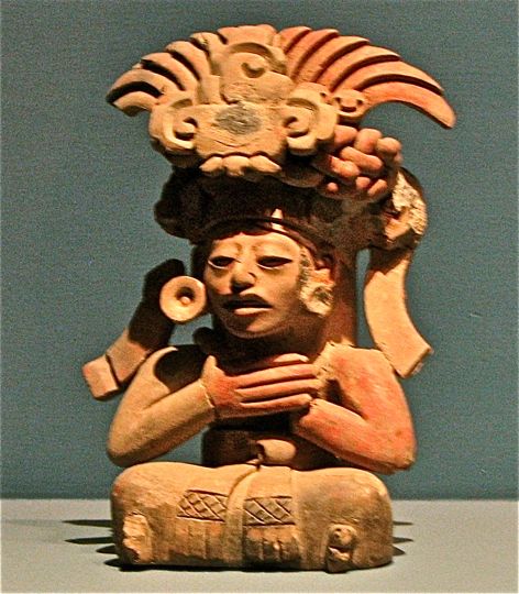 Zapotec funeral urn found in a Monte Alban tomb. The figure is a young man wearing an elaborate head dress. He also wears a necklace and ear spools, probably of jade. The head dress is formed by the jaws of a jaguar, a sacred animal, and topped by feathers. He sits cross-legged, wearing a patterned and fringed loin cloth which lies over his legs. The position of his hands, crossed over his chest, is one of reverence. The urn can be found in the museum at the entrance to Monte Albán.
 Another funeral artifact. This one was unlabeled in the Monte Albán museum, so I call him "Seated Monster". The body is that of a well developed young man with the head of an animal, possibly a jaguar. Fangs droop from a protruding snout, and the creature's long tongue lolls out of its mouth. He wears ear spools, bracelets on his upper arms and wrists, and a loincloth, as well as interesting sandals on his feet. On his head is an elaborate head dress typical of that worn by the Zapotec elite.
 The Sunken Patio looking southwest from the Teotihuacan Quarter. In the center of the photo you can see the Sunken Patio, bordered on the south by a staircase leading to the large columns, with a temple called Building B on the right. The North Platform contains a series of these sunken patios, surrounded by temple pyramids, and connected to one another by staircases and walkways. In the distance you can see Building K, bracketed by two trees, and its twin Building M further south.
 The Sunken Patio and it altar in the center. The Patio is entered by staircases on each of its sides, which correspond to the four cardinal directions. The altar in the center was clearly the focus point of many great religious ceremonies. The staircase on the southern side (upper left of photo) leads to the platform with the great columns, while the other three staircases lead up to large temple pyramids. The temple pyramid on the upper right of the photo--the west side--is Building B. Sunken patios like this are typical of the Teotihuacan influence on this part of the city. What appears to the spot in the sky is actually a large butterfly which flew into the middle of my shot.
 Building A faces Building B across the Sunken Patio. Building A sits on the east side of the Sunken Patio. The wide, flat slabs which border either side of the staircase are of typical Zapotec style.
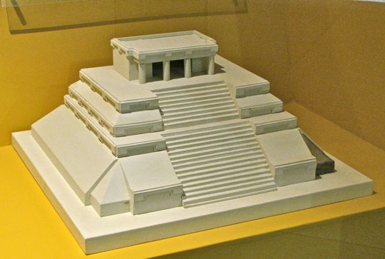 What Building A may have originally looked like. This model, found in Monte Albán's museum, shows how Building A may have originally been structured. Traces of pigment remains indicate that the temples would have been smoothly stuccoed and vividly painted in red and other bright colors.
  Building I sits to the north and above the Sunken Patio area. This temple pyramid has not been excavated to any large degree. Most of Monte Albán may have looked like this to early archaeologists. Building I has a small sunken patio of its own on its south side, bordered by a series of partially restored rooms such as the one in the foreground. It was not clear to me whether these rooms functioned as residential spaces or were used for ceremonial purposes.
 Building VG was a part of the Teotihuacan Quarter. A group of structures sits on all four sides of a sunken patio at the highest point in Monte Albán's North Platform. This temple pyramid/patio area is called the Geodesic Vertex Group. To the west (above) is Building VG, to the south is Building E, to the north is Building D, and to the east is a low platform with a couple of pillars which probably supported some kind of roof. The patio is relatively small and gave me an odd impression of coziness compared to the much larger Sunken Patio to the south, not to say the Great Plaza.
 Climbing the temple pyramids is not for the faint of heart, or the unsteady. The steps were high, narrow and very steep. Since I do a lot of hiking up steep, rocky mountain trails, the staircases didn't both me. However, as you can see, many people who climbed them felt the need for support while descending. Climbing is not allowed on many of the structures at Monte Albán for safety reasons as well as to protect the stonework. I found the easiest way to mount and descend was to move diagonally across the staircase.
  Stone slabs form the doorway of an ancient palace. Tomb 105 was found underneath this palace, which is located below and to the northeast of the North Platform near the parking lot. This palace was constructed at the height of Monte Albán's power and influence ((500 - 800 AD). It was part of another elite neighborhood, on the opposite side of the North Platform from the one seen earlier. Tomb 105, which I unfortunately had no time to view, has stone walls and great stone slabs for a ceiling. The stone is stuccoed smoothly and covered with brilliant murals showing a procession of priests. They are richly adorned with necklaces, armbands, feathered head dresses, short skirts, and sandals. Some carry spears and bags of copal incense. The influence of Teotihuacan can be seen in several elements of the murals, and this may well have been the residential neighborhood of their ambassadors and wealthy merchants.
 A tiny ball court lies just to the west of Tomb 105's palace. It was constructed very late in the history of Monte Albán (600 - 800 AD). I have seen ball courts all over the Meso-American area, but never one this tiny. It was perhaps 15 meters (50 ft.) long, but only 2 meters (6.5 ft.) wide at the narrowest part of the capital "I" which forms the court. The sides, which are part of the playing area, slope up to a height of only 1.5 meters (5 ft.) or so. Its location indicates that it may have been a neighborhood court for a small group of the elite. Ball courts carried religious significance, but may also have been used to settle disputes. I found it odd that Monte Albán contains not only the second largest ball court (after Chichen Itza) in Meso-America, but also one of the smallest.
 View from top of Temple E, looking directly south. Many of the main features of Monte Albán can be seen from this position. In the lower right is the large Sunken Patio with the columns at the top of the grand staircase. In the far background is the South Platform. On either side of the photo are the palaces and temple pyramids bordering the east and west sides of the Great Plaza. In the center of the Great Plaza are the temples and buildings devoted to astronomical observations. In the extreme background, the vast Valleys of Oaxaca can be seen receding into the distance.
This concludes my two segments on Monte Albán. Both Carole and I felt our visit to this city built by the "People of the Clouds" was the high point in our visit to Oaxaca. However, there were many other high points to our visit as well. So, perhaps Monte Albán was like a Mount Everest among the Himalayas. If you would like to comment on this posting you can either email me directly or use the Comments section below. If you leave a question in the Comments section, PLEASE leave your email address so I may answer you.
Hasta luego, Jim


