Wednesday, December 22, 2021

Jerez Part 2 of 7: A walk around the Plaza Principal

Details of a elegant old building on the Plaza's southeast corner. This building is one of several ornate buildings bordering the Plaza Principal. The stone facade was carved using cantera, a relatively soft volcanic rock. This material has been favored for decorative uses since pre-hispanic times. Wrought iron balconies and french doors add further touches of elegance. 

In this second part of my Jerez series, I will focus on the south, east, and north sides of the Plaza. Each is filled with structures which used to be residences and commercial spaces owned by wealthy families during the colonial and early Republic eras. Now, the buildings are filled with small stores, apartments, and offices. The Plaza Principal is the core of the historic center of Jerez and, as such, is a rich photographic smorgasbord.

In the early colonial period, the Plaza was used for various purposes, including militia drills, public punishments using stocks and the garrote (a form of strangulation), and to deliver sermons to crowds of newly Christianized indigenous people. Later, it became a public market where rustic booths sold food and other products from the farms and haciendas, as well as goods from Zacatecas, Mexico City, and elsewhere.  

The south side: Andador Candelaria Huizar

View of the southwest corner of the PlazaCandelaria Huizar is an andador (pedestrian-only street). It runs along the south side of the Plaza, beginning just beyond the upright barriers along the curb. This photo was taken during our 2016 visit, but when I recently checked the Google street-view, I discovered that many of the names on the stores are now different. However, the structures are the same. 

Candelaria Huizar (1883-1970) was a composer, musician, and music teacher. Born in Jerez to a working-class family, he apprenticed as a goldsmith at an early age, but chose not to follow that career. As a child, Huizar taught himself to play a guitar and later studied music and learned to play the saxophone and viola. As a composer, he wrote four symphonies that became famous in Mexico. Composers, poets, painters, scientists and writers are celebrated in Mexico as much or more than generals or politicians.


The eastern half of Candelaria Huizar contains historic buildings. The arches above are called the Humboldt Portales and are part of a building once owned by a prominent colonial-era merchant family. The ground floor is now occupied by an ice cream parlor and other small stores. The Moorish arches are part of a style that originated during the 700-year occupation of Spain by Muslim Moors. This style has been used in Mexico ever since the Conquest.

The Humboldt Portales were named for Alexander von Humboldt (1769-1859), one of the greatest scientists and explorers of his own time and possibly of all time. He was knowledgable about geology, mineralogy, biology, botany, meteorology, cartography, philosophy, statistics, and much more. During his 1803-04 visit to Mexico, he stopped at Jerez and stayed in this building, which was owned at the time by the wealthy Escobedo family of merchants.

The Escobedo family can be traced back at least to 1485, when  Francisco de Escobedo was born in Santander, Spain. His grandson, Hernando de Escobedo, was born in 1545 and emigrated to Zacatecas as an adult. Hernando's son Francisco married Maria de Corbarrubias and they moved to Jerez, where their son (also named Francisco) was born in 1640. At the time of Humboldt's visit, Francisco's grandson Pedro Escobedo (1720-1812) headed the family. There are still many Escobedos living in Jerez and Zacatecas.
 
Detail of the building to the left of the Humboldt Portales. This is the same building shown in my initial photo. The coat-of-arms in the center includes a ship's anchor crossed by a wand topped with spread wings. Two snakes are twined around the shaft. The wand, called a caduceus, is the staff carried by Greek god Hermes and is the symbol of medicine. This indicates that the family that built this ornate structure had illustrious ancestors in the medical and naval professions.


More details of the Neo-Classic facade. I always enjoy wandering a town like Jerez, marveling at the intricate architectural details. The building, probably constructed in the 19th century, may have once been a prosperous merchant's home, or perhaps a hacienda owner's townhouse. If it was a merchant, it is likely that the ground floor was his store, while he and his family lived on the second floor. However, I was unable to find out anything specific about the structure's history. 


View to the south along Andador Benito Juarez. The ornate entrance of the building on the right corner belongs to the same building shown in the last two photos. Various food-vendors ply their trade along the walking street. During festivals, this street is sometimes filled with booths. In the distance, you can see the dome of Parroquia de la Inmaculada Concepción, the oldest church in Jerez. 


The Plaza's east side: Andador Benito Juarez

Looking north along Andador Benito Juarez. This view is from the corner of Candelaria Huizar. The Jardin Rafael Páez is on the left. This street is also lined with former mansions and townhouses, some of which date back to Jerez' 16th century founders. El Baratillo, the orange building on the right corner, was once one of those sumptuous residences. Today, it is a farmacia (pharmacy) selling health and beauty products. 

From the smallest pueblo to the megalopolis of Mexico City, plazas follow the general design dictated by King Philip II of Spain (1527-98). The plaza formed the center of the town or city and was generally aligned to the four cardinal directions. 

The main government building occupied all or most of one side, with the church usually occupying another. The remaining sides were set aside for mansions and commercial spaces owned by the colonial elite. This pattern was maintained from the Conquest until after the Revolution. 


Just north of El Baratillo is another former mansion. Traces of elegance can still be seen in the balconies and french doors on the 2nd story. Today, the ground floor is occupied by a cerrajeria (locksmith) and a pastry/ice cream shop. The second floor probably contains offices or apartments or both.


Left of the locksmith is another impressive structure. Numerous small stores line the street level. These include a dentist's office and La Barbara, a place advertised as a "hookah bar" that offers meals and craft beers. Above La Barbara is a doctor's office specializing in obesity, an increasing problem in Mexico. Further along are a coffee house, a liquor store, and a zapateria (shoe store). 


The North Side: Calle San Luis (Highway 23)

Portal Inguanzo occupies the center of the north side. The view is toward the west. This arcade was once part of a mansion built in 1797. The arcade was rebuilt a century later into its present form by members of the Inguanzo family. The patriarch of the family, Don Manuel Diáz de Inguanzo, got his start as the administrator of Hacienda San Jose de Maguey. An ambitious man, he used his salary to buy Hacienda del Tesorero and Hacienda de los Perez. These two properties became the foundation of the Inguanzo family fortune. 


The Portal Inguanzo from the front. Today, the arcade contains a photo shop, a women's clothing store, and an ice cream parlor. If you are surprised at the number of ice cream shops around the Plaza, the explanation is simple. Mexicans are addicted to ice cream. Even in the smallest pueblo, the plaza will nearly always contain at least one shop selling helados (ice cream).

The wealth of the Inguanzo family increased dramatically during the 19th century. Don Manuel's son, Don Eulogio Inguanzo Zesati del Castelu, married Dona Maria del Refugio Amozurrutia de Inguanzo. Her father was the owner of Hacienda La Labor de Santa Gertrudis. By the time Don Eulogio died in 1893, his estate was valued at 280 thousand pesos, a vast fortune in those days. Included were at least three haciendas, various ranches, and several houses around the Plaza, including this one. 


Portal Inguanzo, looking east. Don Manuel González Cosio had built the original mansion and arcade in 1797. After he died, his heirs decided to sell the property to Don Eulogio Inguanzo. He bought it in 1878 for 333 pesos and 33 centavos, which was quite a deal, because the value of the property at the time was considered to be at least 3000 pesos. As new homeowners often do, he promptly remodeled. After he was finished, the rebuilt arcade came to be known as Portal Inguanzo, a name it still carries today.  

This completes Part 2 of my Jerez series. I hope you enjoyed it and, if so, please leave any thoughts or questions in the Comments section below. If you leave a question, please include your email address so that I can respond in a timely fashion.

Hasta luego, Jim


Friday, December 10, 2021

Jerez Part 1 of 7: A Magic Pueblo near Zacatecas

¡Bienvenidos a Jerez! While reviewing all my pictures from Jerez, I found this one and couldn't resist using it for my lead photo. He wasn't anybody special (except to those who no doubt love him). He was just an elderly vaquero (cowboy) with an impressive handlebar mustache and a wonderful twinkle in his eyes. Meeting people like this is what makes Mexico a magical place for me. 

This posting begins a new series on Jerez, a town southwest of the city of Zacatecas. Its formal name is Jerez de Garcia Salinas. In a bit, I'll explain who Garcia Salinas was and his importance in the history of Jerez and the state of Zacatecas. Jerez is one of Mexico's 132 Pueblos Magicos (Magic Towns). The designation was created to highlight places with wonderful architecture, traditions, history and culture.

In Part 1, I'll focus on the west side of the Plaza Principal which contains the Presidencia Municipal (City Hall) and Hotel Jardin.  A group I organized stayed at the hotel when we visited in 2016. The charming establishment faces the Plaza Principal and its lovely garden known as Jardin Rafael Páez.


Overview

Jerez lies to the west and a bit south of Zacatecas. Highway 23 trisects the town from the north, south, and east. Following it will take you directly to the Plaza Principal and its Rafael Páez Garden (marked in green above). The plaza is located in the Centro area of the town, which is the oldest and most interesting part. You can reach Jerez by the 45D cuota (toll road) or by following either Highway 23 or 54 heading north from Guadalajara

While the fastest route is the cuota, the other two highways are scenic and pass through historic pueblos along the way. On our trip, we took the cuota to Zacatecas and then south on 54 to 23 and west to Jerez. Coming back, we took Highway 23 south. Although the return trip took longer because of truck traffic and numerous small towns, the drive was very much worth it. Here is a Google map showing the whole route.


Mural of a raid on a Spanish caravan by fierce Chichimeca warriors. The Gran Chichimeca was the name given by the Spanish to the area through which all three routes pass. The painting above shows a raid on a Spanish silver caravan. It is part of a mural located in the Palacio Gobierno in Aguascalientes. The name Chichimeca is a catch-all term for several tribes of nomadic hunter-gatherers who ferociously resisted any intrusions into their territory. 

Two of the tribes, the Guachichiles and the Zacatecos, lived in the Jerez area. While these natives had traditionally fought on foot, they quickly realized the advantage of the Spanish horses they are seen capturing above. Both men and women participated in the raids and all fought while stark naked. To protect their caravans, the Spanish established a string of fortified outposts along the silver route. Both Jerez and Aguascalientes were among these original military posts.

Although it took the Spanish only about three years to conquer the Aztec Empire, it took them forty years to get the Chichimeca to stop fighting. They tried to use natives captured in the war as slaves in their silver mines, but found them almost impossible to control. Peace only came after a treaty was negotiated in 1590 in which the Spanish agreed to provide food, tools, livestock, and land to help these nomads transition to an agricultural lifestyle. 


The Centro area contains many beautiful and historic buildings. The overall orientation above is to the northeast. The large, heavily-vegetated square in the upper right is the Plaza Principal with its Jardin Rafael Páez. In this posting, I will start with Calle del Sanctuario on the west side of the Plaza. One of the most important structures along this side is the Presidencia Municipal (equivalent to a US county seat), located on the south half of the block. The other is the Hotel Jardin, on the northern half.

Other sites covered later in this series include the Sanctuario Nuestra Señora de la Soledad, a block south of the Plaza on Calle Del Sanctuario. Across the street from the Sanctuario is the Edificio de Torre, a former girls' school with wonderful Gothic-Moorish architecture. Directly behind (west) of the Sanctuario is Jardin Miguel Hidalgo, dedicated to an Independence War hero. Two blocks east of the Sanctuario is the Parroquia de la Inmaculada Concepción, the oldest church in Jerez. There is much more, but these are the main sites.


La Presidencia Municipal

The Presidencia Municipal viewed from its south end. It faces the Plaza Principal and its Jardin Rafael Páez across Calle del Sactuario. Three iron balconies, with two french doors apiece, line the second floor. The ground floor entrance gives a hint of the elegance that lies within.

The Spanish first passed through the area during the 1529-30 exploration by Nuño de Guzman, a conquistador who was bloodthirsty even by Spanish standards. Some oral histories contend that Jerez was founded at this time, but written documents say it happened in 1570, forty years later. Nuño de Guzman's brutality set the stage for a revolt called the Mixtón War which lasted until 1541 and severely hampered Spanish settlement of the Gran Chichimeca


The Baroque-style entrance is wide enough for carriages. The doorway is framed with cantera, an easily-carved volcanic stone used in many colonial-era and 19th century buildings. The entrance was part of the original mansion, which was built between 1730-45. A fire in 1913 destroyed most of this earlier structure, but the entrance survived and became part of the new building.

In 1546 local natives showed some silver nuggets to a visiting Basque noblemen named Juan de Tolosa. He quickly located the source of the silver at the site of the present-day city of Zacatecas, 44km (27mi) to the northeast of Jerez. Tolosa soon established a small mining settlement to exploit his discovery and this set off a stampede of Spaniards into the Gran Chichimeca. The native people reacted with fierce resistance, particularly after the Spaniards began enslaving them to work in the mines. 


The courtyard, viewed from the northwest corner of the 2nd floor arcade. The street entrance can be seen in the upper left. Notice the closely trimmed topiary in each of the four garden spaces around the fountain.

Following the discovery of silver, Chichimeca warriors regularly attacked caravans bringing supplies from Guadalajara and others returning with silver ingots. After a number of these pack-trains were plundered and their drivers and escort massacred, the Spanish decided to set up a string of military posts at regular intervals along the route. Haciendas were established to supply both the forts and the caravans with food, horses, and draft animals.

The fort at Jerez was founded on January 20, 1570 by Captain Don Pedro Carillo DávilaHe was granted extensive lands in the surrounding area as a reward for pacifying the native people. Those who assisted him included Pedro and Cristóbal Caldera and Martin Moreno. Along with Captain Dávila, these men became the leading citizens of the new settlement.


A Portrait of Francisco Garcia Salinas hangs on the wall of the Presidencia. He was born near Jerez in 1786 on Hacienda Santa Gertrudis and grew up to be a remarkable and visionary politician as well as a financial wizard. While Garcia Salinas is dressed in a military uniform, I can find no mention of a military career in his record. 

I find this odd, because he would have been 24 when the War of Independence broke out and he had a lifelong interest in politics. In addition, his political career spanned a time when Mexico suffered considerable internal warfare. The answer may simply be that this is how a state governor dressed at the time.


View of the courtyard garden from its northeast corner. Francisco Garcia Salinas was born into a wealthy family and they sent him to religious schools for his education. After graduating, he gained valuable knowledge and experience in financial matters while working for various mines around Zacatecas

In 1821, during the first year of Mexican independence, Garcia Salinas was appointed Registrar of Finance in Jerez. His popularity in that role resulted in his election, two years later, to the Mexican Constitutional Congress. Only a year after that, in 1824, Garcia Salinas became a Senator. His exceptional financial skills soon led to his appointment as Mexico's Minister of Finance. 


A pink and yellow rose glows in the morning sunlight. In 1828, Garcia Salinas was elected Governor of Zacatecas. His work in that position gained him acclaim as a "model governor". Banditry plagued the state, so he organized a police force and a National Guard to combat outlaws. In addition, he acquired land and gave it to farmers who pledged to act as a militia against bandits. 

During the Independence War, several important silver mines had been abandoned, seriously damaging the state's economy. Through his efforts, they were reopened. To develop a textile industry, he brought in master craftsmen with looms. He also consulted with experts on sheep breeding to improve the quality of wool. 

To promote education, the young governor established the state's first library, founded a teacher's academy and passed a Primary Education Act. During his time in office, smallpox epidemics broke out in Zacatecas. In response,  Garcia Salinas organized the vaccination of 40,000 children. 


A bored policeman scrolls through his smart phone. In 1832 the political career of Francisco Garcia Salinas ended abruptly, when he backed the wrong side in one of the early Mexican Republic's many political revolts. He was forced into retirement and died of lung disease in 1841 at Hacienda San Pedro Piedra Gorda. In his honor, Jerez was re-named Jerez Garcia Salinas and the University of Zacatecas adopted his name as well.


El Hotel Jardin

Looking south along Calle del Sanctuario. Visible in the distance are the steeples of the Sanctuario de Nuestra Señora de la Soledad. The three-story building in the center of the photo is Hotel Jardin. The vegetation across the street from the hotel is part of the western border of Jardin Rafael Páez. Just a little beyond Hotel Jardin is the long, two-story Presidencia Municipal

The Saga of Anthony's Wallet. The account of our visit to Jerez wouldn't be complete without this story. When we arrived at the hotel, my good friend Anthony discovered that his wallet containing all of his money and credit cards was missing. The last time he could remember having it out of his pocket was during a stop about twenty miles or so before we reached Jerez. Anthony was determined to find it, but most of us were dubious about his prospects. 

The hotel's structure is narrow and extends back from the street. for some distance. The ground floor contains the reception area, restaurant, kitchen, and a couple of guest rooms. All the other rooms are on the two upper floors. Except for those facing the street, the other rooms don't have windows. However, that is not necessarily a disadvantage. Mexican plazas can be noisy at night, particularly during fiestas. I always do my best to get a room as far from the street as possible. 

The Wallet Saga (continued). Anthony quickly found a taxi driver named Jesus who was willing to take him back to our last stop. As they set off, the rest of us discussed taking up a collection so that Anthony and his wife Katherine could still enjoy the trip. A couple of hours later, he returned, triumphantly waving his wallet. We were astonished and eager to hear the story. And what a tale it was!


The restaurant is cozy and colorful, with murals on the walls and tiled table tops. The food served includes Mexican standards like enchiladas, but also some local specialties. All of it was plentiful and tasty. The hotel staff was very friendly and accommodating to our group of fourteen, which filled most of the hotel's eleven rooms. 

The Wallet Saga (continued). When Anthony and Jesus arrived at our last rest stop, they found nothing. At this point, Jesus had become almost as invested in finding the wallet as Anthony. He pressed Anthony to recall any other place the wallet could be. Finally,  Anthony remembered that, after reaching Jerez, we had become entangled in a series of roadwork detours. This led us into a cul-de-sac, where Anthony had gotten out of his car to help direct us.


This cook was one of the friendly staff we encountered. She seemed very happy that I was taking an interest in her kitchen. One of our party celebrated his birthday during our visit and we had brought a cake along for the event. When we discovered that the candles had been overlooked, the staff quickly scurried around to come up with some. We reciprocated by making sure they each got a big slice of cake.

The Wallet Saga (continued). Anthony described the street to Jesus, who recognized it as his childhood neighborhood. What are the odds of picking the one taxi driver who grew up there? Truly amazing! They drove to the cul-de-sac and looked around, but again no wallet. Finally, Jesus began knocking on the doors of the people he knew. One of these folks remembered that a neighbor living a few doors away had mentioned finding a wallet that afternoon. 


A colorful staircase leads up from the reception area. The riser of each stair is decorated with talavera tiles. More tiles were inset in the stone floor. The two ground floor rooms are behind the stairs.

The Wallet Saga (continued). Anthony and Jesus went to the house, explained their quest, and were promptly invited in. Anthony's wallet was on the kitchen table, with all of his money and credit cards! He was amazed at this turn of events. Jesus' persistence and the honesty of the neighbor had combined to save the day. To reward them, Anthony divided the cash in the wallet between the two. He knew he could replace it from a nearby ATM, now that he had his bank cards back. A happy ending for everyone!


My room was simple but comfortable and very inexpensive. You may notice there is no phone or TV. However, many of our party had brought their cell phones, so that was no problem.  Since we didn't plan to spend much time in our rooms, and most TV programs in places like Jerez are in Spanish, the absence of television didn't matter either.

The Wallet Saga (continued). Upon Anthony's triumphant return, we all wanted to hear the story. However, we decided the tale would be best told to us as a group over dinner. Anticipation grew as dinner was served that night. Finally, Anthony recounted the whole saga, while we gasped with astonishment at his luck and applauded Jesus and the neighbor for their parts. The Saga of Anthony's Wallet exemplifies what many of us have come to love about the Mexicans we meet.


The bathrooms were clean, with plenty of hot water. Showers are much more common than tubs in Mexico, but I am a shower person so that was fine with me. I always make sure to check for hot water at an unfamiliar hotel, because in some it is only available at certain times of the day. Hotel Jardin had a plentiful supply during out visit.

This completes Part 1 of my Jerez series. I hope you enjoyed it. If you are so inclined, please leave any thoughts or questions in the Comments section below or email me directly. If you leave a question, please include you email address so that I can respond.

Hasta luego, Jim


Friday, October 29, 2021

Jamay Part 5 of 5: La Maltaraña and its beautiful Villa Cristina

The Villa Cristina is dilapidated but still impressive. Approaching it, wearing the hat, is my friend Alfredo. Ahead of him are our two guides, Tony and Rosy, from the Oficina de Turismo in Jamay. Isla La Maltaraña, where the old mansion stands, has become famous (or infamous) because of legends about its association with Porfirio Diaz, who ruled Mexico with an iron fist for 35 years. 

In this final part of my Jamay series, we'll take a look at the casa grande named Villa Cristina, which is now commonly called Bella Cristina. For the purposes of this posting, I'll call it by its original name. I'll also show you the fortified bodega that stands nearby. Along the way, I'll recount some of the property's fascinating history. 

After I originally published this posting, I heard from Tony Burton an historian of the local area who has written several books about the history of Lake Chapala. These include Western Mexico: A Traveler's Treasury, Lake Chapala Through the Ages and his new book If Walls Could Talk. He very kindly filled in some of the blanks in the story and offered some useful corrections which I have now included. 


Finding La Maltaraña. The casa grande is at the northern edge of the pueblo called La Palmita on Isla Maltaraña, near where Rio Lerma empties into Lake Chapala. Heading east through Jamay on Highway 35 you will come to a calle (street) called Prof. Eusebio Garcia Briseño. Look for a grocery store called Super Mercado on the corner and turn right there. Drive three long blocks to the "T" intersection with Calle Morelos

Turn left and then turn immediately right onto Carretera Gallardo, which branches off Calle Morelos at an angle toward the southwest.
Follow Gallardo for approximately 7.5km (4.7mi) until you reach the bridge over Rio Lerma. Once across the bridge, you will see a small green sign on your right that says Maltaraña. Continue past the sign until you reach the first paved street on your left, called Benito Juarez. Turn left there.

Drive one block and then turn left for two blocks to a "T" intersection. On your left, about 50m away, you will see the bodega. It is a large, brick building with a tall hexagonal bastion on its right end, topped by a turret. Park and walk toward the bodega. From there, off to your right across a field, you will see the Villa Cristina. On this Google map Villa Cristina is shown as "Hacienda Bella Cristina." 


Villa Cristina


The casa grande was built in the French style. In his efforts to modernize Mexico, Porfirio Diaz brought in experts from Britain and the United States to build his railroads. For the arts, however, Diaz looked to France. Clothing fashions in the French style quickly became popular among Mexico's wealthy elite and French art and architecture blossomed in the cities. 

However, aside from Villa Cristina, there have been few examples of French architecture at haciendas I have visited. One other is the casa grande called La Florida at Hacienda Atequiza. Both casa grandes were built during the Porfiriato, as the period of Diaz' rule was known. The owner of Hacienda Atequiza was a wealthy man named Manuel Cuesta Gallardo.


Manuel Cuesta Gallardo (1873-1920). He was born into a wealthy and politically influential family able to trace its ancestry back to the Spanish Conquest. An indication of Cuesta Gallardo's status is that the godfather of his children was none other than Porfirio Diaz. In 1903 Manuel acquired the Hacienda de Atequizaa vast estate founded in 1556. There are stories that Presidente Diaz visited La Florida during his Semana Santa (Easter Week) vacations at Lake Chapala. However, according to Tony Burton, this has not been confirmed in the available records.

Manuel Cuesta Gallardo was an avid proponent of all the late 19th century's technological advances, including telephones, internal combustion engines, and electrification. He invested heavily in hydroelectric projects around Lake Chapala, using his brother, Joaquin Cuesta Gallardo, as the chief engineer. In 1890s, Diaz passed laws giving the federal government (effectively himself) control of the water and shoreline of the lake. 

Manuel Cuesta Gallardo seized this opportunity and persuaded Diaz to authorize a dike running from Isla Maltaraña to Hacienda La Palma on Lake Chapala's southern shore. His brother Joaquin directed the 1906-1909 project, which drained Cienega Chapala, a wetland that once made up the eastern third of the lake. Manuel later sold off the land at a huge profit. 


A two-level hexagonal tower stands over the main entrance. At the top is a railing surrounding a mirador (lookout) which provides expansive views in every direction. Unlike the bastion tower attached to the bodega, which was designed for defense, this one was probably intended for aesthetic purposes. Villa Cristina has 365 doors and windows, one for each day of the year. Clearly, it would have been a very difficult structure from which to fend off attackers.

La Maltaraña was originally part of Hacienda Cumuato, owned by José Castellanos. He hired the architect Guillermo de Alba to build the mansion in 1903-04. Castellanos named Villa Cristina after his wife. In approximately 1905, Joaquin Cuesta Gallardo acquired Isla La Maltaraña and its lovely casa grande. According to Tony the acquisition occurred under "dubious circumstances". However, its location would have been ideal for the headquarters of the dike project.


Villa Cristina, from the rear. Alfredo, Jim B, and Gary examine the back side of the casa grande. Our guides cautioned us against entering the house because of its instability and the support poles provided convincing evidence. Numerous sources refer to the casa grande's 365 doors and windows. Although I didn't count them, there are certainly plenty and Villa Cristina must have been airy and full of light. 

To the left, the earth rises up to form another of Cuesta Gallardo's dikes. This one runs along Rio Lerma, keeping it within its banks during the rainy season. All the dikes, land drainage, and hydroelectric projects created great economic benefits. However, these flowed primarily to the Cuesta Gallardo family and secondarily to the hacendados who purchased the former marshland from them. 

The indigenous communities who had supported themselves from Cienega Chapala's fish and other wildlife were impoverished when it was drained. Small farmers who wanted to grow corn could not compete with the rich hacendados who rushed to buy up the new lands for cash crops like sugar cane and sorghum. Public resentment against the Cuesta Gallardo family began to grow.


El Presidente Porfirio Diaz (1830-1915), in all his glory. His full name was José de la Cruz Porfirio Diaz Mori and he ruled Mexico from 1876 to 1911. He was born in Oaxaca into a poor family, and his father died when he was only three. However, Diaz managed to acquire an education and attended a seminary in preparation for the priesthood. The 1846 U.S. invasion of Mexico changed all that. Diaz volunteered, abandoning religious life for a long military career. 

His exploits during the Reform War (1857-60) and the French Occupation (1861-67) won him a national reputation. In particular, Diaz' victory against the French in the May 5, 1862 Battle of Puebla is still celebrated every year as Cinco de Mayo. In addition to these formal wars, Diaz participated in numerous revolts against one Mexican regime or another. Although he started out as a radical Liberal, supporting Benito Juarez against the Conservatives, Diaz also had personal political ambitions. 

Following the expulsion of the French in 1867, Juarez was seated as President of Mexico. Diaz then led several revolts against Juarez and his successor, Sebastián Lerdo de Tejada. He finally managed to overthrow Tejada in 1876 and installed a crony as temporary President. The following year, Diaz won the first of a total of seven terms. That 1877 election was probably his only legitimate election. The Porfiriato was finally ended by the Mexican Revolution. Diaz left for exile in Paris in 1911 and died in 1915. 


Chuck adjusts his camera as he emerges from the cellar. (Photo by Jim Boles) Our guides told us that this cellar may have been used by Diaz as a torture chamber for his political enemies. According to them, chains and manacles had been found dangling from the stone walls. However, the stairs down into the cellar were blocked, so we were unable to confirm any of this. Legends of all kinds abound in Mexico and I've learned to be skeptical. 

Whether torture happened here or not, Porfirio Diaz was definitely an autocrat. He coined expressions like cinco dados o cinco balas ("five fingers or five bullets", meaning a handshake or death). Another favorite was "pan o palo" (bread or the stick). For 35 years, Mexicans put up with this. Diaz' rule had brought stability after more than six decades of revolts, foreign invasions and chaos, starting with the Independence War of 1810. 

In addition to stability, the Porfiriato was about modernization. Had the benefits of it been spread widely among Mexicans, Diaz would be remembered fondly and the Revolution avoided. However, the wealth created flowed primarily to Diaz and his inner circle, even as the lives of ordinary Mexicans deteriorated. Strikes by workers protesting poor wages and working conditions were crushed. Campesino protests against hacendado land seizures were ignored or repressed. A vast explosion became inevitable.


La  Bodega


Cattle graze peacefully beside the old bodega. Like the one at Hacienda San Miguel de la Pazthis bodega was built as a fortress to protect the valuable products of the hacienda and to function as a refuge in case of an attack. The high brick walls are supported by buttresses. The row of holes just above the tops of the buttresses may have been gun slits. The only door is protected by a hexagonal bastion on one corner of the building. 

On November 20, 1910, the Revolution broke out. A little more than two months later, on March 1, 1911, Manuel Cuesta Gallardo took office as Governor of the State of Jalisco. He had been warmly supported by Porfirio Diaz. However, the Cienega Chapala project had drawn considerable public ire. This was further fueled by anti-Diaz sentiment and revolutionary fervor.

The final straw came when several people were killed by police gunfire at a demonstration against the new Governor. The public outcry forced Manuel Cuesta Gallardo to step down on March 28, after less than a month in office.


The bastion has gun slits on each of its hexagonal sides. The crenelated top would have provided a good view of any attacking force.The railing running along the top of the wall would have provided cover for riflemen. Both Manuel and Joaquin were involved in producing grain alcohol, a commodity that would have required close security, along with all the rest of the estate's valuable goods.

In 1912, Manuel was again humiliated when he ran for election to the Federal Senate. One of the key issues in the election was land reform, which his opponent supported and Cuesta Gallardo denounced. Manuel got more votes than his opponent but fraud was charged after it was discovered that more votes were cast than there were registered voters. The election was then invalidated by the federal Chamber of Deputies and Cuesta Gallardo never took office. 


Antique farm equipment stands near the bodega. (Photo by Jim Boles) After the drainage of Cienega Chapala, the rapidly expanding haciendas quickly began to plant sugar cane, sorghum and other cash crops. Soon, they dominated most of the arable land in the area. Corn, the staple food of ordinary people, had been the main crop of the small farmers and indigenous communities. In the stampede for profits, the corn producers were squeezed out. Many lost their lands to the haciendas through legal maneuvers and even by illegal expropriations. 

Manuel Cuesta Gallardo married Victoria Gómez Rubio, another member of the elite stratum of society. The wedding took place in 1917, only three years before his death in 1920. In 1900, his brother Joaquin had married Antonia Moreno Cocuera. Upon his death in 1915, Antonia inherited La Maltaraña. She didn't occupy the property for long, however.

The Revolution was reaching its height about that time and violent struggles over land were breaking out everywhere. In 1917, land reform was enshrined in the new Mexican Constitution. After two of Antonia's sons were killed in a dispute over La Maltaraña's land, she departed. With that, the Cuesta Gallardo family's connection with the property ended and it passed into the hands of Luis Aviña and Mauricio Orozco.


Alfredo and Rosy clown for the camera. Our group learned a lot while having a great time. Our guides, Rosy and Tony worked hard and went out of their way to show us the best of Jamay, including La Maltaraña and the historic Villa Cristina. They even took us to a great local restaurant where we were serenaded by mariachis. We reciprocated by treating them to lunch and giving them a very good tip before we parted. 

In spite of the provisions of the new Constitution, Luis Aviña and Mauricio Orozco fiercely resisted the distribution of any the land at La Maltaraña. This continued even after the local people formed an ejido (communal land organization) and tried to use the new legal procedures. The two hacendados employed every means, legal and otherwise, to obstruct and delay the process. In 1934 Presidente Lázaro Cárdenas was elected and threw his support behind land reform, but still Aviña and Orozco fought against it. 

Both sides committed acts of violence in this struggle. It was not until 1960 that the campesinos finally took possession of the lands they had been legally entitled to for so long. Today, Villa Cristina stands as a symbol of the opulence and greed of Mexico's great landowners and the desperate struggle that it took to break their grip on the country.

This concludes Part 5 and ends my Jamay series. I hope you have enjoyed this one, as well as the other parts. If so, please leave any thoughts or questions in the Comments section below or email me directly. If you use the Comments section to leave a question, please be sure to include your email so that I can respond in a timely manner.

Hasta luego, Jim


Monday, October 18, 2021

Jamay Part 4 of 5: Hacienda San Miguel de la Paz

Tall brick columns line the front of the casa grande. Unlike Hacienda San Agustin, shown in my previous posting, Hacienda San Miguel de la Paz is not in very good shape. Still, it has a fascinating history, as well as a number of interesting architectural features. The people exiting the porch are members of our group. The wall to the right of them is festooned with colorful ads for the political candidates of various parties.

We never know exactly what we will find when we go in search of a hacienda. Sometimes they are in perfect repair and may still function as agricultural operations. At other sites, the buildings may have been converted to other uses, as is the case with this one. Still others are in ruins, slowly crumbling in some remote pasture. However, we have almost always found at least some trace, even if it is only a part of one wall. 

More than 110 years have passed since the Mexican Revolution began. By the end of that struggle, the dominant position that haciendas had occupied in Mexico for hundreds of years was overthrown. Many of the sites that we have been able to find and explore may not exist in another 20, 50, or 100 years. I am glad to have had the opportunity to find these old haciendas, and show them to others before most of them have disappeared. 


How to find Hacienda San Miguel de la Paz.  Head east from Jamay on Highway 35 for about 4.2km (2.5mi). Turn left at an overhead sign pointing north to San Miguel de la Paz. Drive 9.5km (6mi) on the San Miguel-Jamay highway to the outskirts of the pueblo. Once you enter San Miguel, the name of the street on which you are traveling changes to Calle Epigmenio Zaragoza

Continue on that street until you reach the Plaza Principal. Turn left on Calle Antonio Ramirez along the south side of the Plaza. Drive one block and then turn right for two blocks on Calle Manuel Dieguez, along the Plaza's west side. On the left corner, you will see a small red, white, and blue auto parts store, with a sign saying Refaccionaria. Down an alley just to the right of the store, you will find the front arcade of the casa grande. Click here for a Google map. 

La Casa Grande

Two of our party walk down the arcade toward the entrance. The columns and walls of the casa grande were built with red brick that was once completely covered by white plaster. On either side of the main entrance, there are four tall windows in the Neo-Classic style. The somewhat shabby condition of the building today cannot conceal its once elegant appearance.

According to a wall plaque, the casa grande was built in 1910, the same year the Revolution broke out. The hacienda for which the casa grande was the centerpiece had been created by joining together two separate haciendas, both of them dating to 1800. One was Hacienda San Miguel, located 2.5km (1.55mi) north of the current pueblo in an area called El Potrero Nopales. The other was Hacienda La Paz. Its site was 4km (2.5mi) to the south in El Potrero Cosme


Front entrance of the casa grande. The door seemed a little odd to me, as if it had been designed for a family of very tall and skinny giants. It opens into a foyer called a zaguan, which is a typical feature of a casa grande. This leads into a central courtyard. Red brick is a material often found in haciendas built during the late 19th and early 20th centuries, their most prosperous period. Before that, adobe and stone were more commonly used because of low cost and easy availability.

There were economic and dynastic reasons why the two older haciendas were combined into one, with this casa grande built as the new headquarters. First, the construction of a railroad line through the area in 1910 transformed the local economy, as it did wherever a rail line was built in Mexico. It made good business sense to combine the two haciendas in order to increase production.

Previously, goods had to be transported over unpaved roads on wagons or by pack-trains of burros. A journey to Guadalajara, the largest market in the area, took several days. Transport by rail cut the time to hours. Railroads also created links to national and even international markets. Until the last half of the 19th century, the typical hacienda was modestly profitable at best and often served primarily as a symbol of social status. Now, profits skyrocketed. 


The second reason to combine the two older haciendas was dynastic. The portraits above were taken at the marriage of Miguel Orendáin and Dolores Faustiana Somellera. The joining together of Hacienda San Miguel and Hacienda La Paz into a much larger estate was part of the marital arrangements negotiated by the two families to give the young couple a good start in life.

The Orendáin family appears to have emigrated to Mexico from the Basque town of Orendáin in northern Spain. Among the first to arrive was Vicente Orendáin. He settled in the pueblo of Tequila in the early 1800s and became one of the founders of Mexico's tequila industry. Vicente bought his first tequila-distilling hacienda from José Cuervo in 1836. The Orendáins later sold that property to Don Cenobio Sauza in 1889. Today, Orendáin, Cuervo, and Sauza are major tequila brands. 

All this is to say that the Orendáin family was wealthy and socially connected. From a dynastic point of view, encouraging a marriage between Miguel and Dolores to create a larger and more profitable hacienda was a "no-brainer". I have no information about Dolores' family, but she was certainly from the same social class, since her family had a spare hacienda to contribute as her dowery. 


Casa Grande interior

Remains of a doorway arch where the zaguan opens onto the courtyard. Assisted by his brother Javier, Miguel Orendáin rapidly consolidated the two old properties and built an impressive new casa grande as the headquarters of new hacienda. No doubt, the increased revenues from access to the new railroad line helped pay for it all. 

While some of the largest haciendas, like Atequiza and Mazatepec, had the wealth and power to demand their own railroad stations, Hacienda San Miguel de la Paz doesn't appear to have had one. However, stations at the nearby towns of Ocotlán and La Barca would have been close enough to easily transport their goods for rail shipment. 


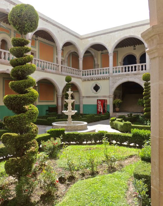
Courtyard of the casa grande. The balloons and chairs had been set up for a party to celebrate the birth of a new baby to one of the town's families. The casa grande and other structures were taken over by the ejido (communal farmworkers organization) after the land reform that followed the Revolution. The casa grande now functions as a community center for classes, community events, and parties.

Miguel Orendain and his wife appear to have been generous to the small community that was growing up around their hacienda. They funded the construction of a new church and built housing for the priests. In addition, they built a school for the community's children, supervised by the priests. The Orendains are remembered by elderly residents as reasonably enlightened. 


The meaning of the stork is the same in Mexico as in the U.S.  My good friend Jim B took this shot of me as I explored and photographed the casa grande's interior. Since I am always behind the lens, I seldom appear in my blog's photos. I always appreciate it when one of our group thinks to take a shot of me that I can include.

La Bodega

If you think this bodega looks like a fortress, you're right.  The thick walls are 15m (49ft) high and are supported by massive buttresses. On top of each corner is a circular bastion with gun slits. The railing between the bastions could be used by riflemen to train their weapons on attackers.The only entrances are four large doors along the front. Today, there are metal curtains which can be raised and lowered, but once there were thick, iron-studded wooden doors.  

So, why was a bodega constructed like this? The storehouse is 1000sq m (3281sq ft) and it functioned as a strongbox to protect the most important products of the hacienda. For almost 130 years, from 1810 through the mid-1930s, Mexico was wracked with wars, insurrections, revolutions, and chaos. Groups of armed men roamed the countryside. Some were military units of one faction or another. Others were simply bandit gangs, sometimes made up of former soldiers with no better prospects. 

To maintain themselves, food and horses were vital. The finery to be found in a casa grande was all well and good, but what they needed to keep operating was all stored in the bodega. Since it was the most defensible structure available, the hacendado and his workers could fortify themselves there against these assaults. They could hold out against most attackers using the food the bodega already contained, assuming they had stored an ample supply of water and ammunition.


A small arched structure stands above the entrances. This was the campanario (bellfry). The now-missing bell was used to summon the workers in the morning and dismiss them in the evening. Since few, if any, of the peones would have possessed watches, the bell was an important means of controlling the workday. Another of the bell's functions was to alert everyone to approaching dangers, such as bandit attacks or fires.

Eventually, Miguel Orendain sold the hacienda and his family moved elsewhere. The new owners were Antonio, Miguel and Trino Martinez, three brothers who are not fondly remembered in the community. They attempted to maximize profits by demanding strict twelve hour work days. If a peon's tool broke, they forced him to pay for it through extra unpaid work. These tactics probably succeeded for a while, but the Revolution eventually brought change to San Miguel de la Paz.

Mexico's post-Revolution land reform came in waves. The first was in 1917, with more waves in the 1920s. The final round occurred during the 1934-40 term of Presidente Lázaro Cárdenas. In 1936, the hacienda's workers formed an ejido and land reform finally came to Hacienda San Miguel de la Paz. The three Martinez brothers, seeing the writing on the wall, abandoned the hacienda and left the community in possession of the land and its buildings.


The turret of a corner bastion. Notice the gun slits. The fact that the ejido wasn't formed until the mid-1930s is probably due to several factors. First, it is likely that the relatively benign, paternalistic style of the Orendains made people reluctant to demand land from them. Second, the Martinez brothers, like many other hacendados, would have used every scheme they could think of to fight off the formation of the ejido

In the 1920s, during the second wave of land reform, many hacendados tried to fight it by forming alliances with the Cristero forces then rebelling against the government. The Cristeros were Catholic reactionaries who fought against the implementation of the Constitution of 1917, which restricted the power of Mexico's Catholic Church. Some hacendados used Cristero gangs as death squads to assassinate ejido leaders, in return for supplies and hiding places. 

Cristeros were active around San Miguel. They dynamited the tracks of the railroad so they could assault the train for the payroll it carried. Residents of San Miguel were pleasantly surprised that the government soldiers who passed through on their way to fight the Cristeros were polite and didn't abuse or steal from them. While the national government finally suppressed the revolt in 1929, it is likely that efforts at San Miguel de la Paz to win land reform were inhibited until the conflict's end. 

This concludes Part 4 of my Jamay series. I hope you enjoyed it. If so, please leave any thoughts or questions in the Comments section below or email me directly. If you do leave a question, please include your email address so that I may respond in a timely fashion.

Hasta luego, Jim