Monday, October 29, 2018

Lago de Bacalar and the town that bears its name

A long pier extends into Lake Bacalar with palm-roofed palapas at its end. One of our priorities during our adventure to the Southern Yucatan Peninsula was to visit Lago de Bacalar, famous for its crystal-clear water. The lake has been important to people living in the area since pre-hispanic times. Today, it is a popular attraction for young, back-packer types, as well as older folks like us. In this posting, I'll give you a peek at the lake and the small town on its western shore that bears the same name. In later postings, I'll provide some history about the area, including pirate raids and bloody Maya revolts.


Lago de Bacalar winds snake-like through the low, coastal jungle. At several points, it bulges like a python that has swallowed a pig. Mostly, however, the lake is quite narrow along its 42 km (26 mi) length. At its widest, it is only about 2 km (1.24 mi) across. The lake extends from the southwest to the northeast, roughly parallel to the shore of Bahia de Chetumal. The lake's southernmost point is only a few kilometers from Rio Hondo, a river that flows eastward from the interior of the Peninsula to the Bay. This geography meant that Lake Bacalar was an ideal route for ancient traders, since it was always easier to paddle a canoe full of trade goods than carry them on your back. Traders traveling from north to south could portage their goods to Rio Hondo and then paddle into the interior or out to Chetumal Bay and the Caribbean coast.


Another pier, with two palapas, extends out from a lakeside hotel. Lago de Bacalar is famous for the clarity of its deep blue water, enhanced by the white limestone bottom. The freshwater lake is fed by underground rivers that emerge into open pools called cenotes (limestone sinkholes). Because of the porosity of the Peninsula's limestone base, it has almost no lakes or rivers. Lake Bacalar is by far the biggest body of surface water. Its source is the world's largest subterranean cave system, with 450 km (280 mi) of natural tunnels


Map of the town of Bacalar. Route 307 curves through the center from south (left) to north (right). While the town extends west of the highway, most of it lies to the east, between the highway and the lakeshore. As of the 2010 census, Bacalar had 11,084 residents, making it the second largest city in the southern part of the state of Quintana Roo. Only Chetumal is larger. When the Spanish arrived in 1543, Bacalar was already a city. The Maya called it B'ak Halal, which means "surrounded by reeds". It was the first place the Spanish conquered in the area and, when they did, the Maya name was transformed into "Bacalar".


A kiosco stands in the middle of a well-maintained plaza. Surrounding the plaza are various restaurants and tourist facilities. While most of the town is made up of modern 20th and 21st century buildings, a few colonial structures have survived. The most impressive of these is an 18th century Spanish fort called Fuerte de San Felipe.


A cannon points out toward the lake from a bastion at Fuerte San Felipe. The fort was constructed in 1729 to guard against the pirate attacks that, for centuries, plagued Spain's colonial possessions in the New World. The old colonial city of Campeche, on the Yucatan Peninsula's Gulf Coast, is still surrounded by fortifications similar to the ones at Fuerte San Felipe. Along the shoreline below the fort, you can see some of the town's many hotels and restaurants.


The fort's thick exterior walls are surrounded by a deep moat. Part of the moat can be seen above, just beyond the wall in the foreground. The walls were built with limestone, which is readily available in the area. The crenellations (slotted sections) along the top of the wall would have been used by soldiers to shelter themselves while they pointed their muskets through the openings. After Bacalar was sacked by pirates in the 17th century, the Spanish Crown finally provided the resources to built the fort. In a future posting, I will show more of Fuerte San Felipe's fortifications, as well as relics of the piracy that plagued the area.


The palapas at the end of the piers are relatively simple structures. Set on rough pilings driven into the lakebed and roofed by thatched palm fronds, the structures offer shade from the intense sun of the warmer months. Since the structure is completely surrounded by water, it remains fairly cool, even on a hot day. If an occupant gets over-warm, s/he has only to hop into the water for a refreshing dip. In the cooler months of winter, when we visited, it can get pretty windy in the Peninsula's coastal areas. In that case, the palapa's walls offer some protection.


Lily pads along the lakeshore. Lake Bacalar is home to a wide variety of plant and animal life. It also contains a large quantity of stromatolites, which are sheet-like sedimentary rocks that have the appearance of cauliflower. They were formed by single-cell photosynthesizing microbes called cyanobacteria, the oldest life form on earth. Such fossilized formations are very rare in the world.


Tourists frolic in the lake's sparkling water while a sailboat cruises in the distance. The folks in sailboats were probably thrilled by the wind, even if it did kick up the water a bit. Despite the water's choppiness that day, it didn't seem to deter tourists from enjoying a swim.

View of Fuerte San Felipe from the end of one of the piers. The Spanish built the fort so it would dominate approaches to the town from the water. Quite a number of boats were available for tours of the lake and we thought about hiring a launch. However, with the water so rough, we decided to spend our limited time exploring the fort's excellent museum and strolling the shoreline.


There are quite a number of lakefront restaurants. There are many places to dine and they kind of blend into one another. We decided to just wander around until someplace caught our fancy.


Entrance to the restaurant we picked for lunch. Unfortunately, I didn't note the name of the place, but it is on the southern end of the town's lakefront and easy to find. You have a choice of the covered patio, the garden, or a table right on the water. As you can see, there is enough seating that you really don't need a reservation. The menu choices are primarily Mexican dishes, with a good selection of seafood.


Tables by the water offer grand views of the lake. However, the wind was pretty strong at this point, so we picked a more sheltered spot in the restaurant's garden. Because we wanted to visit the Maya ruins of Chacchoben, a few miles north of the lake, we didn't spend more than a few hours at Bacalar. The town would be worth a return visit, perhaps even for an overnight stay. Bacalar is an easy drive from Chetumal and you pass through some lovely country along the way.

This completes my first posting on Bacalar and its beautiful lake. In the next one, I'll tell you a bit about the area's dramatic history. If you'd like to ask a question or leave a comment, please use the Comments section below or email me directly. If you leave a question in the Comments section, please provide your email address so that I can respond.

Hasta luego, Jim

Saturday, October 20, 2018

Oxtankah's Plaza de Tortugas, the Astronomer's Pyramid, and the Early Colonial Open Chapel

The North Platform of Structure I in Plaza de Tortugas (Turtle Plaza). This platform should not be confused with Structure I of the Plaza de Abejas. The one above was part of a palace laid out on a north-to-south axis. In the photo, you are looking southth along its top toward the Central Edifice, beyond which is another long narrow platform. Together, these structures form the eastern side of the Plaza de Tortugas. The Turtle Plaza is situated between the Plaza de Abejas and Plaza de Columnas (shown in the last two postings). The Structure I palace faces west toward the un-excavated structures of Plaza Tortugas.


The Central Edifice of Structure I rises slightly above the platforms on either side. The two platforms extend to the north and south like wings. All of these may have once had structures on their tops made of perishable materials. Oddly, the broad staircase has a narrow set of stairs built into it on the right. The narrow stairs may have had some special, ceremonial function or this may simply be a product of different construction phases. Other than their names, I have been unable to find any information about Structure 1 or the Plaza de Tortugas. There were no on-site informational markers and Structure 1 doesn't even appear on most site maps, even those in the detailed archeological reports I Googled up.


The South Platform of Structure I forms its right wing. The Central Edifice can be seen in the upper right corner of the photo. Why there is so little mention of Structure I is a mystery to me. It has been well-excavated and can't be missed on the trail between the two main ceremonial plazas. I have described it as a palace, because it somewhat resembles the palaces in the two main plazas. However, it could have had religious or administrative purposes as well. It also occurred to me that the long, low staircases would have provided excellent audience seating for religious processions between the Plazas of Abejas and Columnas.


One of the local residents is also a mystery. I scoured hundreds iguana photos on Google Images and could find none that resembled this handsome guy. He was sunning himself in front of Structure I when I encountered him. I would greatly appreciate an i.d. from any lizard experts out there. Notice the bright orange end of its tail. Iguanas and some other lizards are able to detach part of their tails when they are threatened. The detached part writhes and wriggles to distract the predator while the iguana escapes.


Structure XI: The Astronomer's Pyramid


Structure XI, the Astronomer's Pyramid, is a mix of architectural phases. The earliest phase is the broad, circular base, seen in the foreground. This may have had an astronomical function, hence the name. The top section, built at a later time, is a square, five-stepped pyramid. The narrow staircase in the center of the photo is the main entrance to the square pyramid.


View of Structure XI from the right. The Astronomer's Pyramid is part of small group of buildings called the Plaza de Kanjobal. The other structures of the plaza are un-excavated mounds of rubble.


Side view of the stepped levels of the circular base. Virtually all of the pyramids in Mesoamerica are "stepped" meaning that their base is the broadest part, with each level above being somewhat smaller, kind of like a wedding cake. The ramón trees in the foreground are ubiquitous at Oxtankah. Their roots have broken up many of the walls and steps of the various structures here.


Limestone chultun located near the Astronomer's Pyramid. There are very few above-ground sources of fresh water in Yucatan. In the northern part of the Yucatan Peninsula, cenotes (limestone sink holes) provide the primary source. However, in the Southern Peninsula, they are scarce. The ancient Maya solved this problems by cutting bottle-shaped chambers, called chultunes, down into the limestone. Drainage channels were then cut to the chultunes so that rainwater runoff from buildings and plazas could be collected and stored.

The Early Franciscan Open Chapel

The enclosed areas of Open Chapels are relatively small. Capillas Abiertas (Open Chapels) became distinctive features of Mexican Catholic architecture during the early 16th century Spiritual Conquest of Nueva España (Mexico). They were used by Franciscan friars as they evangelized indigenous populations. The mass conversions conducted during this period meant that there were often thousands of people who attended services. Building churches that would fit them all was beyond the resources of the friars. Most of Mexico's great cathedrals and basilicas were still a century into the future. In addition, the indigenous people were accustomed to attending pagan rituals conducted in the open air in front of their temples.

The friars' solution was to gather the indigenous people they were evangelizing into a large, un-roofed area, called an atrium. Facing the atrium would be a simple, open-faced chapel. The area behind the arch, called the presbytery, was roofed, but the archway itself was kept open so people could see the rituals that were being conducted. To the left of the presbytery is a sacristy where priestly vestments and other religious articles were kept. The room on the right, accessed from the front of the chapel, may have been used for administrative purposes or as temporary quarters for the itinerant friars.


 The presbytery and altar. At the back of the presbytery is a raised area containing the altar. Oxtankah's Capilla Abierta was built in 1544, shortly after the conquest of the region around Chetumal Bay. It is quite similar to the one we saw at Dzibilchaltún, a pre-hispanic Maya ruin near Mérida in northern Yucatan. The Spanish often constructed their churches and chapels in areas that indigenous people had been venerating for centuries. Oxtankah had long been a sacred precinct to the local Maya, even during the period of its abandonment between 600-900 AD. Thus, it is not surprising that this Capilla Abierta was built only a stone's throw from the Plaza Abejas.

This concludes my series on the ancient Maya city of Oxtankah. I hope you have enjoyed it and, if so, please leave any thoughts or questions in the Comments section below or email me directly.

If you leave a question in the Comments section, PLEASE leave your email address so that I can respond.

Hasta luego, Jim

Friday, October 12, 2018

Oxtankah's Plaza of Columns

Structure X is a palace with four columns along its front at the top of a broad staircase. The columns prompted archeologists to give the Plaza de Columnas its name. The palace is one of five structures surrounding the plaza, which is one of Oxtankah's two main ceremonial areas. The other is the Plaza de Abejas, seen previously. In this posting, we will take a close look at the pyramids, palaces, and temples that surround the Plaza de Columnas. As you may remember from the previous posting, the names of both plazas, and of Oxtankah itself, were given by the archeologist who excavated them back in the 1930s. Their original, pre-hispanic names remain a mystery.


Overview of the Plaza de Columnas

Plaza de Columnas is surrounded by a large pyramid, two palaces, and two un-named structures.  The plaza's orientation is south-to-north and west-to-east.  The north side, at the bottom of the schematic, contains Structure X (in Roman numerals, X=10). This is an edifice that I will call the North Palace. Above it, on the left (east) side, is Structure VI (=6), a large pyramid from which multiple human remains and many grave goods were recovered. On the top (south) side of the plaza are two un-named pyramids about which I have no information. Structure IX (=9), which I will call the West Palace, is located on the right (east) side. It has a broad staircase on the side facing the plaza and multiple rooms along its top. When excavated, one of of these rooms was found to be a kitchen. We will begin our tour of the plaza with the Structure X palace and proceed clock-wise around the plaza. Since I could find no information or names for the two structures on the south side, they will not be included in this posting.


I had to allow this handsome guy his 15 minutes of fame. Everyone deserves at least that. A visitor to Oxtankah will encounter iguanas of various sizes and hues throughout the ancient city's ruins. This one is known to scientists as Ctenosaurus similis and is the largest iguana within the genus Ctenosaurus. It can be found throughout Central America and parts of the Yucatan peninsula. Although this species is able to run faster than any other lizard, this one remained motionless for the entire time I was taking its picture. While the focus of my Oxtankah series is on the two main ceremonial plazas, there are numerous others, mostly unexcavated. One of the smaller plazas was dubbed Plaza de Iguanas.


Structure X: The North Palace


The North Palace, viewed from atop Structure VI. This palace contains three rooms on its top and two more at the rear. These were apparently the dwellings of rulers and their families. This is one of the few major structures at Oxtankah that contained no human remains when it was excavated.


Stucco mask of an elite male, possibly one of Oxtankah's actual rulers. He wears an elaborate, feathered head-dress, long jade earrings, and a jade necklace. All this indicates a person of very high status. His lower jaw and cheeks are painted, or possibly tattooed. color. There was no explanatory sign, but the mask may have had a funerary function. It might also have decorated a wall in the North Palace or elsewhere. The mask can be seen in the small museum at the entrance of the site.


Rear view of the North Palace. The two rooms at the rear of the palace can be entered from the doorway seen above. The rear rooms were added sometime after the palace was originally built. This might have occurred at the end of the Early Classic Era (200-600 AD), just before the interval of abandonment, or during the Post-Classic Era (1000-1520 AD) when the site was re-occupied.


Tripod vessel found at Oxtankah. This is definitely high-status pottery and could well have been used by the city-state's ruler. The pot bears a striking resemblance to Teotihuacán's tripod vessels. Teotihuacan was the capital of a huge trading empire of central Mexico from 100 to 650 AD. This was the same time frame as Classic Era Oxtankah. This pot may have arrived a Oxtankah from Teotihuacan through the trade networks, or Maya potters could have simply copied the style from other imported ceramics. Teotihuacan had a close connection with the Maya World, particularly the Petén region stretching across northern Guatemala and the southern Yucatan Peninsula. In fact, the  Petén city-state of Tikal appears to have been ruled by Teotihuacan for a period of time. Teotihuacan itself had a whole district set aside for Maya immigrants and traders. Under these circumstances, it would not be surprising to find a Teotihuacan pot in an important Maya trading seaport like Oxtankah, even though the two cities were 1145 km (711 mi) apart.


Structure VI: The Pyramid with Multiple Tombs

Cutaway view showing the tombs of Structure VI. The pyramid has four stepped-levels, with a single-story temple on top. Facing west, toward the plaza, is a single broad staircase, with the upper and lower sets of stairs divided by a landing. Inside the pyramid, five tombs containing the remains of twelve individuals were found. Two of the tombs are located under the staircase and the others are located in the center of the pyramid, under the temple. Most of the human remains were too deteriorated to determine age or sex, but one has been identified as a female. Examination of the teeth indicates that all were adults except for one and all had been buried during the Early Classic Era. Because they were buried within the pyramid, and because of the quality the grave goods interred with them, this was certainly a group of high-status individuals, possibly members of a royal family.


View of Structure VI and its main staircase. The pyramid appears to have two sets of stairs separated by a gap in the middle. Originally this was one broad staircase, but archeologists created the gap when they tunneled into the stairs looking for the burials. In 2014. a team of scientists published the results of their analysis of the remains of 73 individuals buried at Oxtankah, including those of Structure VI. All 73 were interred within the various structures surrounding the two main ceremonial plazas. A total of 55 individuals were found in Structures I, III, and IV at the Plaza de Abejas. Another 18 were buried at the Plaza de Columnas, including the 12 in Structure VI and another 6 in Structure IX. None were found in Structure X. Of the 73 individual remains, only four--two male and two female--were complete enough to determine sex or age at death.

The reason that so many of the remains are so fragmentary and deteriorated may be that the overwhelming majority were secondary, rather than primary burials. With secondary burials, the body was buried elsewhere for some period of time and then the remains, or parts of them, were moved to the site where they were ultimately discovered. A primary burial is one where the remains were left in place and are therefore more likely to be relatively intact. The practice of secondary burial was widespread among the pre-hispanic people of the southern Yucatan Peninsula and northern Belize and Guatemala.


For the benefit of tourists, a facsimile of a skeleton was placed in Tomb 2.  The original remains were so deteriorated that there was no way to determine sex or age. As yet, there is no evidence that any of the 73 individuals were victims of human sacrifice. In most of the other pre-hispanic sites I have visited in Mexico and Central America, there has been clear evidence of ritual killings. Sometimes, this occurred as part of the dedication of new (or re-built) temples and pyramids. At other times it was to propitiate the gods, or to celebrate an accession to the throne, or as part of the rituals associated with the pre-hispanic ball game. It would  have been unusual for this particular city-state to forego these practices. At the moment, there is no evidence either way.


Arrangement of bodies and grave goods in Tomb 1, in Structure VI. In this tomb, and another area below it, a total of 11 individuals were interred. All were adults except for one child. Only one female has been identified as such among the group, although there may have been more. The grave goods found among the remains were sumptuous. Notice, in particular, the necklace worn by the individual at the lower left.


A sampling of the objects found in Tomb 1. The necklace at the top was worn by the person seen in the previous illustration. It consists of 1,620 small, pearly beads carved from mollusk shells. Tiny holes were drilled in each so they could be linked together, somewhat like chain mail. The bottom edge of the necklace is bordered by oval earrings and "L" shaped attachments, both of which were made from snail shells. To see the whole, extraordinary garment, click here. This  assemblage demonstrates astonishing quality and craftsmanship. It also illustrates the range of uses the people of Oxtankah found for their oceanic resources. Also shown are a small mask made of red coral, a jade necklace, a greenstone ax, and a fine piece of pottery. Grave goods are important to archeologists because objects deliberately and carefully buried in a tomb are more likely than others to survive intact through the centuries. Also, objects left in tombs, particularly those of elite persons, are likely to have a special significance. Analysis of such objects provides a window into the minds of ancient people.


The temple atop the pyramid has a single, rectangular room. The temple's roof was made of perishable materials which did not survive the centuries. The entrance of the temple room, at the center left, faces a niche containing a small altar. The scientists who studied the teeth found with the remains wanted to understand which populations were most in contact with the people of Oxtankah. Their analysis indicated a close relationship with the city-states of Dzibanché and  Calakmul. Both are located in the south-central area of the Yucatan Peninsula, some distance from the coast. There were more tenuous links with the Maya of the Petén area of northern Guatemala. Oxtankah's connections with these areas were the result of its status as a key trading port on the coast of Chetumal Bay.


The altar of the temple is set in a small cubicle about the size of a modern closet. Even after Oxtankah was depopulated and largely abandoned during the Epi-Classic Era (600-900 AD), offerings were left at its temples and pyramids. Apparently people still living in the surrounding regions continued to revere Oxtankah's religious sites. In addition to the offerings, several of the 73 burials occurred during the Epi-Classic Era.


Structure IX: The West Palace

Schematic view looking down on Structure IX, the West Palace. This palace was built in several stages. The earliest was during the Early Classic Era and the last occurred in the Post Classic. In the first phase, two small, low platforms were constructed with rooms along the top. A passageway separated them. The remains of these rooms can be seen on the left of the schematic. The walls were once decorated with vividly-painted images of important elite figures, similar to the mask seen previously. Other areas were covered with religious symbols. When the long-abandoned city was repopulated at the beginning of the Post-Classic Era, the newcomers rebuilt this palace. The Early Classic platforms were covered by a long rectangular platform containing four rooms. Three of the rooms appear to have functioned as royal living quarters. In the schematic, they can be seen just above the staircase in the center.  The fourth room, on the far right, served as the palace's kitchen.


Structure IX's Post-Classic Era platform. A broad set of steps leads up to three royal living areas. Other rooms stretch off to the left and right on either side. The scientists doing the tooth study found six individuals buried in five tombs within the West Palace. One tomb contained two individuals but the other four tombs only contained one apiece. Five individuals were adults of indeterminate age or sex. However, the sixth set of remains was determined to be an adult female. All the burials were from the Early Classic Era.


View along the top of the West Palace, looking south. The room in the foreground was the kitchen. Given its close proximity to Chetumal Bay and the Caribbean, the diet of the city's inhabitants was rich in seafood. Thousands of shells from a variety of mollusks were recovered throughout Oxtankah. The thatched-roof palapa in the distance protects some of the Early Classic rooms from the elements.


Early Classic Era room, on the extreme south end of the West Palace. At the upper right of the photo is a door which leads to other Early Classic rooms. Notice the high quality construction of the walls on either side of the room. In contrast, the wall at the end is rough and appears to have been thrown together. This may indicate that the construction standards of the Post Classic Era were not up to those of the Early Classic.

This concludes the third part of my Oxtankah series. I hope you have enjoyed it. If so, please leave any thoughts or questions in the Comments section below. Alternatively, you can email me directly.

If you leave a question in the Comments section, PLEASE leave your email address so that I can respond.

Hasta luego, Jim


Thursday, October 4, 2018

Ancient Oxtankah's Plaza of Bees

The pyramid known as Structure I is shrouded by ramón trees. In my last posting, I presented a broad-stroke picture of Oxtankah. This time, we'll take a detailed look at a plaza that is one of its main features. The Plaza de Abejas ("Plaza of Bees") was given that name by Alberto Escalona, the archeologist who excavated the ancient city in the 1937. He also named the city Oxtankah, which means "three neighborhoods surrounded by ramón trees".  The scientific name for a ramón tree is Brosimum alicastrum. The three neighborhoods referenced include the two main ceremonial areas, Plaza de Abejas and Plaza de Columnas, as well as Plaza de Tortugas, which lies between them. I will show these last two plazas in my next posting. What the ancient Maya called these plazas, or their city, is unknown.


Overview of the plaza


Detail from a site map of Oxtankah, showing Plaza de Abejas. For a look at the full map, click here. Shown above are six structures, laid out in a rough oval. At the lower left is Structure I, a pyramid containing two tombs. Just above it is an unnamed pyramid that I didn't photograph because it is mostly rubble. At the top is Structure III, a long, rectangular palace with a grand staircase in the middle. Structure IV, at the upper right, is a temple notable for a mysterious stucco inscription at its entrance and its odd, maze-like interior. At the bottom is another palace with a columned terrace and a spacious patio, but which lacked any informational signs. None of the various site maps I have since consulted gives it a name. In the center of Plaza de Abejas is a large altar containing two tombs in which multiple individuals were buried. I will show these structures in the clock-wise order I have just outlined.


The ancient Maya Bee God from a hieroglyphic text called the Códice Madrid. Beekeeping among Yucatan's Maya began as early as 300 BC and has continued into modern times. They favored the stingless bee they called xuna'an kab ("royal lady"). Modern science knows it as Melipona beecheii. The ancient people used their bees to produce honey, wax, and royal jelly. The honey was used for religious ceremonies, medicinal purposes, and as a sweetener. They also used it to brew balche, an hallucinogenic drink. When Spanish missionaries arrived, they reported a brisk trade of beeswax and honey for cacao beans, another highly valued commodity. The honey bee was so important to the Maya that it had its own god, Ah Mucen Cab, also known as the Diving God. Archeologists called him by that name because he usually appears as an upside down honeybee, as you can see above.


Structure I: The Pyramid With Two Tombs

Structure I is a partially excavated pyramid with a temple on top. The pyramid was constructed with four stepped-levels. The one-room temple, built on the top level, has three levels of its own. The grand staircase is a complex arrangement of stairs, which may have been the result of rebuilding over the centuries. At the foot of the stairs are the remains of three small square altars.


The grand staircase of Structure I, from the left. The pyramid, which is on the east side of the plaza, faces west in the direction of the setting sun. There is a structure in the foreground, at the base of the left side of the stairs, with a top that slopes upward. Its placement is puzzling to me because it seems to impede access to that side of the staircase. The ancient people did not build their sacred structures randomly, or without careful thought, so it may have some ritual function.


View from the fourth level looking down the steps at the small altars. While the steps don't look steep in the previous shot, from here you can see that they really are. This is the tallest structure in Plaza de Abejas and from it the Maya priests could view all the other structures in the plaza. Today, so many ramón trees have grown in the plaza that other structures are hard to make out. The pyramid was built around 300 AD, and functioned until about 600 AD, at which time much of the city was abandoned. Later, in 1000 AD, the city was re-occupied and another structure was built over this one. This was a common practice in ancient Mesoamerican cities. The later structure was still in use when the Spanish arrived in the 1500s. Archeologists removed much of the later structure in order to reveal the original.


The temple has a single, short staircase which leads to a rectangular room. In this room, the Maya priests would perform those parts of their ceremonies that were restricted from the view of the uninitiated. Small bone fragments and teeth from at least 20 individuals were found within the altar of this temple. Similar fragmentary remains of 29 other individuals were found within the two tombs located underneath the temple. It appears that the primary function of the pyramid and its temple was funerary. There is nothing to indicate that any of these individuals were sacrificed. All 49 were adults, according to the analysis of their teeth, but scientists have been unable to identify the sex or age of any of them.


Tomb 1 is entered from the rear of the temple. The rectangular, stone-lined crypt above can be found just inside. The fragmentary remains and various grave goods have been removed for safekeeping. On the wall of the crypt is a niche which once contained sacred objects. The grave goods indicate that the remains of at least one occupant were those of a ruler or other person of great importance. This tomb dates to the period between 300-600 AD and is the earliest explored to date. The pyramid's Tomb 2 was looted, probably during the Epi-Classic Era (600-900 AD) when the city was abandoned for 300 years. The looters left only four objects behind.


How the tomb would have appeared when the ruler was buried. The body would have been placed on its back with the head toward the north. In the Maya view of the Cardinal Points, north was not just a direction. It also indicated the sun's highest position, or zenith. Fifteen objects, known as "grave goods",  were placed within the crypt.


Structure III: The Long Palace

Structure III is the long, rectangular structure seen through the trees.  Here, you are looking southeast from the base of Structure I across Plaza de Abejas. I have dubbed Structure III the "Long Palace" because its length is 60 m (197 ft). At Oxtankah, the palaces of the principal elites were placed around the various plazas and the Long Palace occupies the whole south side of this one. Even at this distance, you can see that the palace's main staircase is quite impressive. The open area of the plaza is quite large and must have been the site of impressive ceremonies involving large numbers of people.


The main staircase of the Long Palace. As usual in Mesoamerican buildings, most of the steps are high and narrow. The palace extends beyond the end of the stairs in both directions. The main building was constructed between 300-600 AD and during this period an adult individual was buried within it. Archeologists believe that this staircase was added later, perhaps after 1000 AD, in the Post Classic Era.


View along the top of Structure III from the right end. You can see the remains of a couple of rooms in the foreground and there are others at the far end beyond the stairs. Rooms made of perishable materials once stood along the top level, but these have long since disappeared. The rooms in this palace were not exclusively for living quarters, but also functioned as reception areas for visiting dignitaries, for administrative matters such as tribute collection, or for storage.


Several rooms are built into the body of Structure III. The one above includes a small staircase. The interiors of the rooms would have been furnished with rugs, cushions, textiles, and various wooden objects. Unfortunately, none of these has survived. The dimensions of the rooms are quite small and would have been dimly lit during the day. Why would privileged elites live in such places? In Yucatan, the climate makes it possible to live outside year-round, so the ancient Maya carried out most activities on the terraces, patios and courtyards. The rooms were used for sleeping or when they desired privacy.


View of the five stepped-levels of the palace. Notice how some of the corners are sharp, while others are gracefully curved. The curved corners are characteristic of the Petén architectural style which dominated northern Guatemala and the Southern Yucatan Peninsula from the Pre-Classic Era to the Epi-Classic. Lime-based stucco once coated the walls, which were painted with multi-colored pictures and designs. The subjects of the paintings were the histories of Oxtankah's rulers and gods.


The Central Altar & Tomb

It was a common custom to place an altar in the middle of a plaza. This may be linked to the belief that the Cosmos had five Cardinal Points. These were north, south, east, west, and the center. The sides of the plaza were oriented to the first four points. The placement of an altar in its center thus linked the whole plaza with the Cosmos. The altar was constructed during the Epi-Classic Era (600-900 AD). This was hundreds of years after most of the other structures surrounding it had been built and during a period when Oxtankah had been abandoned. Some time after 1000 AD, when the city was re-occupied, another alter was built over this one. The newer altar was still in use when the Spanish arrived, five hundred years later. The palm-frond palapa shelter, seen above, protects a tomb.


Three tombs were found within the altar, including the one above. The skeleton is a facsimile created to give visitors an idea of the tomb's contents when archeologists opened it. The body was placed on its back, in the position shown above, with the head facing north. Interestingly, no grave goods were found. Lining the inner sides of the crypt are thirteen flat upright stones, possibly representing the thirteen levels of heaven in the Maya cosmos. Other large flat stones were placed across the upright stones to form a lid over the crypt. No information was available about the contents of the altar's two other tombs.


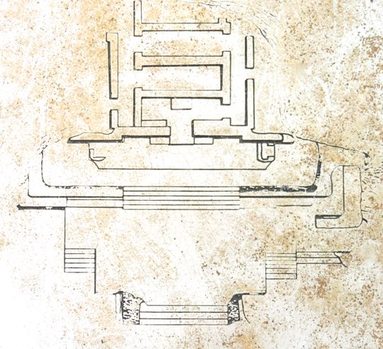
Structure IV: The Temple of Inscriptions

Diagram of Structure IV showing its main features. At the base is a broad platform, which forms a terrace. This stretches out into the plaza and is accessed by multiple staircases. A second platform sits at the back of the terrace. It is accessed by a single broad staircase. The temple stands on top of the second platform and is entered by a narrow doorway. At the base of the step in front of the doorway is a series of mystic symbols formed with red-painted stucco. Inside the temple, the first room contains a stone altar. Other connecting rooms are arranged in an unusual maze-like pattern that probably had some sacred meaning. Structure IV was constructed between 300 and 600 AD. Some time during this period an adult individual was buried here. Between 1000 AD and the arrival of the Spanish, the structure was modified several times.


The temple viewed from the front right. The original temple would probably have had a similar covering to the palapa above. This palapa was constructed by archeologists to protect the temple and its inscription from the elements, The temple faces toward the east and the rising sun, which is also the direction from which Venus rises as the Morning Star. To the ancient Maya, Venus represented the cyclical pattern of fertility and regeneration.


The entrance to the temple's "inner sanctum". The rust-colored inscription can be seen on the step below the passageway. The surface of the terrace floor in front of the temple's entrance is made from lime stucco. The widespread use of this material to cover walls, floors and road surfaces led to deforestation throughout the Mesoamerican world. Some of the consequences of deforestation included drought and crop failures, probably followed by wars, famines, and epidemics. This, in turn, led to the abandonment of cities and population migrations. Oxtankah may have experienced some of this after 600 AD, when it was largely abandoned. Its re-occupation around 1000 AD may have been linked to the regeneration of the forest.


Closeup of the inscription. In the center is what looks like a sort of exclamation point. Some, but not all, of the symbols on each side replicate those on the other. Archeologists have deciphered the various symbols as the eyes, nose, upper lip, teeth of a jaguar, along with its clawed paws. Also included are seashells, snakes, concentric circles, and a lunar eclipse. Each of these had a sacred meaning, but exactly what they meant as a group is still a matter of conjecture.


The "exclamation point" turned out to be the nose and nostrils of a jaguar. Two eyes used to frame the nose but, except for traces, they have long since disappeared. The lines extending out from the nostrils on either side represent the upper lip with large teeth hanging down below. The jaguar was a sacred animal not only to the Maya, but to ancient people throughout Mesoamerica. It is the third largest of all cats, after the African lion and Indian tiger. As a powerful hunter, the jaguar symbolized attributes that were very attractive to ruling elites. Because they hunt at night, ancient people believed that jaguars could pass freely between the worlds of the living and the dead. Other powerful animal symbols in the inscription include coiled snakes and conch shells. Snakes were associated with Kukulkan, the War Serpent, and conches with Chaac, the rain god.


The front room of the temple contains a large, rectangular altar. The altar faces the entry and would have been illuminated by the rays of the rising sun. Maya priests used the interior rooms of their temples to conduct those rituals and ceremonies that persons of lesser status were not privileged to see.


This carved stone decoration bears a striking similarity to the temple's interior. The decoration can be found in the small museum near Oxtankah's entrance. There was no sign to explain where it was originally uncovered or what it might mean, but I was struck by the similarity of its pattern with that of Structure IVs temple interior.


The Nameless Palace 

Another palace occupies the north side of Plaza de Abejas. There was no sign giving it a name or any description. The palace's rooms surround a patio on three sides. The main building, seen above, sits on a broad platform and has a terrace with a line of columns along its front that once supported a sheltering roof. A single small staircase lead up onto the platform. The area covered with green grass is the patio, set a couple of steps up from the surrounding ground.


The patio, as seen from the terrace. The stump of one of the columns is in the right foreground. Long, narrow rooms border the south and west sides of the patio. The room on the west side has an entrance from the patio in its middle. In the southeastern corner, there is a structure somewhat resembling a defensive blockhouse. However, I saw no other signs of defensive works at Oxtankah, so the purpose of this structure remains a mystery to me. The patio and terrace are the most likely gathering places where residents would have socialized among themselves, entertained guests, or worked.

This completes the second of my Oxtankah series. I hope you have enjoyed it and, if so, please leave any thoughts or questions in the Comments section below, or email me directly.

If you leave a question in the Comments section, PLEASE leave your email address so that I can respond.

Hasta luego.