Showing posts with label Tapalpa Plateau. Show all posts

Friday, August 5, 2022

Tapalpa Plateau Part 5 of 6: Hacienda La Media Luna

The ruined casa grande of Hacienda la Media Luna (The Half Moon). This hacienda was once part of several large estates located on the Tapalpa Plateau that functioned until the first couple of decades of the 20th Century. Last July, I organized another of my Hacienda Hunts for a group of friends to visit the La Media Luna. Even though it was mid-summer, the chilly, blustery weather occasionally spattered us with cold rain. However, ours was a hardy group and we took it all in stride.

Hacienda La Media Luna was one of the settings in Pedro Páramo, a novel by Juan Rulfo. He has been acclaimed as Mexico's greatest author, even though this book and another book of short stories are the only major works he wrote. Rulfo invented the style of writing known as Magical Realism, which later inspired Colombian author Gabriel Garcia Marquez to write One Hundred Years of Solitude, another masterpiece. 


Where is ex-Hacienda la Media Luna? The site is 16.5km (10.3mi) southeast of the town of Tapalpa. The hacienda's casa grande (big house) and other ruined structures sit on a low rise overlooking the western tip of a lake called Laguna Grande. A small pueblo called La Lagunilla grew up around the ruins of the old hacienda. For specific directions with an interactive Google map, click here

The Tapalpa Plateau rises to about 2130m (7000ft). This altitude captures the moist air moving in from the Pacific Coast and gives the area a cool, misty, alpine feel. The gently rolling countryside is covered with pine forests and shallow lakes. These are interspersed with fields of maiz (corn), orchards, and pastures filled with sheep, cattle and horses. Tapalpa is the most important town on the plateau. The others tend to be small pueblos like La Lagunilla


La Casa Grande

View of the casa grande from its southeast corner. Several members of our party can be seen near the main entrance. The casa grande was once a two story structure although only the exterior walls of the second story remain. Running along the front of the structure you can see a line of holes where rafters extended out. These supported the roof of the arcade which once shaded the walkway underneath. The open doorway in the middle of the second floor probably provided access to a broad porch.

La Media Luna was founded about 250 years ago, during the latter half of the 18th century. Eventually, the hacienda became one of several in the area that were owned by Juan Rulfo's family. The ruined structure above was originally built in 1884 by his maternal grandmother. It is not clear whether Rulfo ever lived at La Media Luna, but his visits clearly impressed him enough for him to make it one of the key the settings of Pedro Páramo.


View of the capilla (chapel) along the arcade walkway. Like many of the haciendas I have visited, this one has a capilla attached to one end of the casa grande. The structure shown above is not the original capilla, which later become the church of the local community, following the breakup of the hacienda. Over time, however, the old capilla deteriorated and was replaced in 1982 by the one seen above. 

La Media Luna and its casa grande may have been destroyed during the Cristero War (1926-29), one of the aftershocks of the Mexican Revolution (1910-17). Another possibility for its demise may have been the land reform carried out between 1917 and the late 1930s. This process was also accompanied by considerable violence. Today, the ruins stand as a lonely reminder of a vanished era, with only occasional visits from hacienda enthusiasts like those in my group.


Photographing the carriage gate. I am the photographer shown above. To the left is the casa grande and to the right is the beginning of the capilla structure. Like most of the carriage gates of Mexico's old haciendas, this one leads into an interior courtyard where the horse-drawn vehicles were once loaded and unloaded. (Photo by Jerry Brown)

Juan Nepomuceno Carlos Pérez Rulfo Vizcaíno was born in 1917, at the Hacienda de ApulcoThat estate was owned at the time by his maternal grandfather, Carlos Vizcaíno Vargas. It is located approximately 54km (34mi) southwest of Hacienda La Media Luna. The casa grande of Hacienda de Apulco can still be found in the middle of the modern-day pueblo of Apulco. However, the old structure has been occupied by the Monasterio de la Virgen de la Paz for the last 25 years. 


Main entrance of the casa grande. I concluded that this was the main entrance from its size and from the steps leading up to its double wooden doors. The other doors along the hacienda's front have smaller doors and no steps. A large wood beam--almost certainly an original feature--forms the lintel of the door. 

The estates of Apulco and La Media Luna were once part of a constellation of haciendas that surrounded the town of San Gabriel, where Rulfo's family moved when he was two years old. The town became the other major setting in Pedro Páramo.  However, in his book, the author renamed San Gabriel, calling it Comala. This has caused much confusion, because there is a real town of Comala, which is a Pueblo Magico located just outside the city of Colima. 


View into the casa grande from an entrance along the arcade. It is likely that this room was the comedor (dining room). I concluded this because of a second door  connects to a rear room which was probably one of the two cocinas (kitchens) that were once part of the structure. Why two? Not a clue. Notice the framing of the doorway, which is made from dressed cantera stone. The walls surrounding it are adobe brick covered by plaster. 

Rulfo's stories are set between the beginning of the Mexican Revolution and the late 1930s, a violent and chaotic period. At an early age, the author was himself directly affected by the violence. In June 1923, his father Juan Nepomuceno Pérez Rulfo (known as "Cheno") was shot in the back of the head by Guadalupe Nava over a land dispute. Not long after, two of Rulfo's uncles were also murdered.

In 1953, Rulfo wrote a book of short stories called El Plano en Llamas (The Plain in Flames), which drew its title from his father's tragic death. As a six-year-old boy, little Juan had stood in the darkness at Hacienda Telcampana (just south of San Gabriel) while he watched the approach from afar of the flaming torches held by the escort of the cart carrying his father's body. Thirty years later, when titling his book of stories, this searing memory was still powerful.


Interior of a rear room, possibly a bedroom. The room is now overgrown with brush. The walls are made from adobe bricks, which were once covered by layers of plaster. Adobe is made from mud, with straw as a binder. This form of construction was favored by many of those who built Mexico's rural haciendas because the materials could be obtained locally and labor was cheap. 

After his father's death, Rulfo and his mother María continued to live in San Gabriel, where he attended a local religious school for the next three years. Rulfo's life changed again in 1927, when his mother died and then the school closed due to the chaos of the Cristero War. He was left an orphan, but his grandmother took him to live in Guadalajara where he spent the rest of his childhood and youth. However, many of the places and personal names in Rulfo's writing reflect his early life in San Gabriel.


Thick layers of plaster still cover the adobe walls of this room. This is the cocina connected to the comedor seen previously. Above the rafter holes are the walls of a 2nd floor room, which was probably a bedroom. The opening in the wall is a window which has become a door by the addition of a stack of bricks used as a stair. Through this opening, you can see part of the courtyard.

Rulfo continued his schooling in Guadalajara and graduated with a degree in bookkeeping, although he never practiced that profession. He wanted to attend the University of Guadalajara, but was unable to do so because of a labor strike and a lack of preparation on his part. Next, he moved to Mexico City, where he briefly attended the National Military Academy, but left after only three months. 

Following that, Rulfo sought a law degree at the National Autonomous University but, again, nothing came of it. However, he was able to audit courses in literature at the university while working as an immigration agent. This informal educational effort was the beginning of his literary career. He began writing and, in 1944, co-founded a literary journal call Pan (Bread).


View from the courtyard into a possible living room. The rough wooden lintel over the door opening above, as well as the wooden door across the room, are probably original features of the casa grande's 1884 construction. Adobe is one of the earliest construction materials in the history of human architecture and structures built with it can survive for centuries. 

After a few years working as an immigration agent, Rulfo took a job as a sales agent for a private company. Both jobs enabled him to travel widely in Mexico and deepened his understanding of the country. Rulfo then landed a Rockefeller Foundation fellowship at the Centro Mexicano Escritores (Mexican Writers' Center). It was during this two-year period that he wrote both El Plano en Llamas and Pedro Páramo, published in 1953 and 1955, respectively. 


Corner of the back wall of the casa grande. The niche in the wall probably once contained a religious statue, most likely one of the many versions of the Virgin Mary. Above the niche is the truncated remains of another old wooden lintel. This shot was taken from the passageway leading from the carriage entrance to the courtyard.

Although he is most famous for the two great works of literature he published in the early 1950s, Juan Rulfo was also involved in other artistic work, including screenwriting and photography. From 1962 until his death in 1986, he was an editor for the National Institute for Indigenous People. Some of Rulfo's other literary work has been published posthumously, but none of it has approached the fame of his earlier masterpieces. 


La Capilla de la Virgen de Guadalupe

View of the capilla from the rear. The adobe wall to its right is part of an old bodega (storage building). The hacienda system was broken up during the two decades that followed the end of the Revolution. The re-distribution of lands to campesinos and indigenous villages often meant that the former hacendados (owners) could no longer afford to maintain their casas grandes and other structures. 

Often such buildings were simply abandoned and then cannibalized by a hacienda's former workers for materials to build homes and small shops. Many of the pueblos that now dot the countryside grew up around the ruins of old haciendas. Quite often, the only structure to remain intact was the capilla, because it was maintained by the local people as their church. Over time, an old capilla might be replaced because of deterioration, as was the case in La Lagunilla.


The front of the bodega, the capilla's porch and an atrial cross. An open area directly in front of a church, bordered by a low wall, is called an atrium. A stand-alone crucifix found in this area is called an atrial cross. These spaces were used for religious activities that were too large to be conducted inside the church itself. In the earliest times, this included evangelization and mass conversions of the native people.

In Juan Rulfo's novel, the owner of Hacienda La Media Luna was a man called Pedro Páramo. He ruled over his hacienda and the surrounding region like a feudal baron of the medieval era.  Páramo regularly exercised le droit de seigneur (the right of the lord) to have sex with any woman who caught his fancy. The population of Comala (San Gabriel) was thus full of his illegitimate offspring.


Front view of the atrial cross. It is covered with symbols representing the Passion of Christ (the crucifixion events). Since the illiteracy rate in pre-Revolution Mexico was high, the Church went to great lengths to create murals, images, and other visible symbols. Richard Perry, an expert on old Mexican religious architecture, told me that the cross is probably not from an earlier era but may be a 20th century copy of an older version located elsewhere.

In the novel:
While Pedro Páramo relentlessly pursued his lustful adventures, his true love was his childhood sweetheart, Susana San Juan. However, she had married another man and was thus unavailable to him for many years. After she was widowed and returned to Comala, Páramo was finally able to marry her. However, Susana's obsession with  her dead husband led to her into insanity, leaving him once again unfulfilled. While this is one of the central ironies of the book, the story itself begins long after Páramo's death.


The altar of the capilla is devoted to the Virgin of Guadalupe. She is the Patroness of Mexico and its poor and indigenous people. The majority of Catholic churches I have visited in Mexico are either devoted to the Virgin of Guadalupe, or at least have a side chapel or special altar set aside for her. She was the first version of the Virgin to appear in colonial Nueva España, and was unusual because she was dark skinned and spoke Nahuatl, the language of the Aztec man who first encountered her.

In the novel:
Pedro Páramo had a son named Juan Preciado by a woman named Dolores. At the story's beginning, Juan follows the deathbed advice of Dolores to go to Comala in search of his father. Upon his arrival, he finds that Pedro died long ago and that the town is mostly deserted except for the ghosts of its former inhabitants. From these apparitions, we learn the brutal and violent history of Páramo family. 


A message printed on a rough sack hangs on the wall next to the altar. The Spanish printing translates "Consecrated  by the (?) Señor Dr. D. Pedro Loza, 1878". Why this humble sack should be given such an elaborate frame and place of honor is a complete mystery to me, as is the identity of Sr. Dr. D. Pedro Loza. The date on the sack is six years before Rulfo's grandmother built the casa grande at La Media Luna and 104 years before the capilla's re-construction. 

In the novel:
Miguel Páramo, was the father of Pedro and grandfather of Juan Preciado. Miguel was a violent man involved in rape and murder. Upon Miguel's death Juan's father Pedro inherited La Media Luna, along with Miguel's penchant for violence. When Pedro's beloved Susana returned to Comala, Pedro decided to win her favor by secretly murdering her father and then offering to comfort her. He succeeded in marrying her, but she later descended into madness and died.


A spiral staircase leads up the steeple to the campanario (belfry). A man who was repairing the capilla kindly retrieved a key to let us in. I asked if we could climb to the campanario and he agreed, but only after warning us to be careful. I also quizzed him about the hacienda and its casa grande, but he was from another town and could provide little information beyond what I already knew.

In the novel:
When Susana died, Pedro was devastated and decided to hold a grand funeral for her. However, the people of Comala decided not to attend. This enraged Pedro and he took revenge on them by withholding food, causing them to starve en masse. Thus, they became the ghosts from whom we learn much of the story.


One of the belfry's several bells. At the bottom of the photo, you can see part of the casco wall that surrounds the chief buildings of the hacienda. Casco translates as "helmet" in Spanish. The walls of a casco protect the casa grande, bodega, and stables, which together form the nerve center of the hacienda

In the novel:
One of the first of Comala's inhabitants that Juan encounters is Abundio, his half-brother by one of Pedro's many conquests. Through him, Juan learns how their father met his own violent end. When Abundio's wife had died, he went to his father for help in paying for her funeral. However, Pedro refused and Abundio's anger was such that he murdered his own father. Throughout the novel, the themes of murder and revenge reflect the violent and chaotic times of Rulfo's childhood.


A horse grazes in one of the pastures enclosed by the casco wall. The casa grande and capilla are visible in the distance. This concludes Part 5 of my series on the Tapalpa Plateau. If you enjoyed it and have any thoughts or questions, please leave them in the Comments section below or email me directly. If you leave a question in the Comments section, please remember to include your email address so that I can respond in a timely manner.

Hasta luego, Jim


Tapalpa Plateau Part 6 of 6: Hacienda Ferreria de Tula


A horseman rides past former hacienda buildings. William Faulkner once wrote "The past is never dead. It's not even past". This could well be applied to many sites I have visited in Mexico. It is  particularly applicable to the pueblos that were once haciendas, prior to the land reform that followed the Revolution. One of these places is Ferreria de Tula

The afternoon we visited, a ghostly silence pervaded the town. The only sound was the clip-clopping of a horse's hooves. On it, a lone rider made his way up the cobblestone street, passing old adobe structures roofed with red clay tiles along the way. Many of these buildings had been part of the hacienda complex in earlier times. Since then, they have been repurposed as homes, stores, or workshops.


The pueblo of Ferreria de Tula is about 1/2 hour drive from Tapalpa. It is located 26.7km (16.6mi) to the north, off Highway 437. The  drive takes you through the lovely, rolling country of the Tapalpa Plateau, past pine forests and meadows full of sheep, cattle and horses. Highway 437 not only leads to Ferreria de Tula but continues north, taking you back toward the Lake Chapala area. For a Google interactive map of the whole area, click here.

Structures of the former hacienda

Ruins of a hacienda building. At first, I thought this might be the remains of the casa grande (big house). However, the lack of windows, or of any of the ornamentation typical of a casa grande made me doubt my first impression. I now think this was part of the industrial complex and that the casa grande was one of the buildings facing the cobblestone street seen previously. The structure above may have been the center of the complex.

In Spanish, ferreria translates as "ironworks", making this one of the more unusual haciendas that I have visited. The vast majority of haciendas in Mexico were farms or ranches (or a combination of the two). However, some were sugar processors, while others were involved with various kinds of mining. However, I had never before encountered a hacienda devoted to the production of iron. The need for such a facility in a remote place like the Tapalpa Plateau baffled me at first.


Another old structure along the main cobblestone street. Now a private residence, this may have been a house for one of the hacienda managers or possibly an office. The plaster-covered adobe, protected by its red tile roof, seems to have held up well over the centuries.

My puzzlement about this hacienda led me to do some research on ironworks in the colonial and early Republic periods (1500s - 1800s). Why would the Tapalpa area need such a facility? There were no railroads up here that required iron tracks and few towns of any size that would have used iron for construction or for industrial machinery during this time. So why an ironworks?


This large stone building may have once been the casa grande. A hacienda's casa grande often contained much more than just the residence of the owner. It was usually an administrative center containing offices, storerooms, and sometimes a tienda de raya (company store). There, peones would collect their pay and purchase necessities. In order to keep the workforce in place, they would often be paid in script or coins produced by a hacienda that could only be spent in its tienda de raya.

Ironworking in Mexico started with the arrival of the Spanish. Pre-hispanic civilizations, particularly those in Peru and Western Mexico, had been working with metals such as copper, silver, and gold for some time. However, they had not yet made the jump from copper to bronze and iron was entirely unknown to them. At the beginning of the Conquest, the Spanish crown initially banned the exploration for iron in the New World in order to protect Spanish industry.  


Former stables and outbuildings behind the casa grande. Stables on a hacienda are nearly always found in close proximity to the casa grande, because that's where the hacendado (owner) kept his personal horses and family carriage. This was also where a blacksmith might be found. These craftsmen were highly-valued on haciendas because they could produce horseshoes, nails, hinges, latches, and other objects vital to day-to-day living. To make these items, blacksmiths required raw iron.

The Spanish Crown's prohibition on iron production was almost completely ignored. Intent on exploration and conquest, the early 16th century conquistadors needed weapons, armor, and saddlery, as well as other iron materials for construction and ship repairs. Waiting for all this to arrive from Spain was entirely impractical. Ironworks and blacksmithing operations were undertaken almost immediately. 

La Presa (The Lake)

Stone buttresses support a dam at one end of La Presa. It is probable that the water from the lake once powered the ironworks. Otherwise, why build the dam immediately across from it? Initially, a traditional waterwheel may have been used. However, by the late 19th or early 20th century, the waterwheel may have been replaced by a water-driven electric turbine.

From the 16th until the mid-18th centuries, Puebla and Oaxaca were Mexico's main ironworking centers. However, by the end of the 18th century, ironworks could be found in many areas, including Jalisco. Because of the on-going trade with the Philippines by the famous Manila Galleons, ironworking styles in Western Mexico had a strong oriental influence.


Jim B scaled one of the buttresses to take a look at the lake. Jim has been exploring haciendas with me for almost as along as I have been going on these expeditions. I noticed that the buttresses on this side of the dam look a bit deteriorated. Hopefully, this doesn't indicate any weakness. The dam's failure would devastate the portion of the town that occupies the low area below the dam.

Blast furnace technology arrived in Mexico in 1807, when it was installed in the Guadalupe foundry. Gradually, ironworks all over Mexico began to adopt the new technologies being developed in Europe and the United States. In 1879, machinery manufactured by the Siemmens Company was brought over from Germany, allowing the production of cogwheels, corrugated rods, and drawn iron.


View of the lake, from the top of a buttress. The lake stretches off into the distance for approximately 1000m (3000ft). It varies from about 150-200m (450-600ft) wide. Today, the lake provides water for livestock and the fields and orchards in the immediate area, as well as the town itself.

How the hacienda came to its end is still unclear to me. It probably didn't survive the land reform following the Revolution. However, I haven't been able to nail down exactly when this may have happened. While poring over a Google map of the town, I did discover the location of the local ejido. These are communal land-owning organizations to which hacienda lands were transferred during the period between 1915 and the 1940s.


Water rushes from the spillway on one side of the dam. Like many other places in Mexico, Ferreria de Tula has erected a multi-colored sign proclaiming the town's name to visitors.


Iglesia de Guadalupe

The Iglesia de Guadalupe stands on a hill overlooking the lake. We were unable to go inside the church because the gates were all padlocked and we didn't have time to search for someone with a key. The church is named after Nuestra Señora de Guadalupe, the Patron Saint of Mexico and of its poor and indigenous people. 


The church's two campanarios (bell towers) have two bells in each. While looking over the church with my telephoto lens, I discovered signs of damage to the campanarios. Also, the window on the bottom right lacks glass. This part of Mexico has quite a number of volcanos, some of them still active. Given the unstable nature of the terrain, I suspect that the damage came from earthquakes. 


An elderly man makes his way along the side of the dam. His traditional straw sombrero (hat) and leather huaraches (sandals) makes him seem like a figure out of the past. The cobblestone street lined with old adobe buildings add to the feeling. Scenes like this sometimes make me feel that I have stepped back into the 19th century.  Faulkner was right, the past is never past.

This completes Part 6 of my series on the Tapalpa Plateau and also the series itself. I hope you have enjoyed it and, if so, you will leave any thoughts or questions on the Comments section below, or email me directly. If you leave a question, please include your email address so that I can respond in a timely fashion.

Hasta luego, Jim


Wednesday, August 3, 2016

Hiking the Tapalpa Plateau

A trail winds through the pine-forested Tapalpa Plateau.  The Tapalpa Plateau lies about two-hour's drive southwest of Lake Chapala. On its eastern side is a massive escarpment which rises more than 2000 feet above a long, north-south valley. The valley floor is filled with farm fields and a chain of shallow lakes which dry up part of each year. The switchbacks on road up the escarpment provide dramatic views of the valley below. Once on top, you find rolling country filled with lush meadows, sparkling lakes, and deep pine forests. This is gorgeous country! I have previously blogged about adventures in the area, including El Salto Waterfall and Chiquilistlán Gorge. The Tapalpa Plateau is huge and covers an area within a rough triangle between three roads. Highway 54D (the Guadalajara-Colima toll road) forms the eastern side of the triangle. Highway 429 is the southern side, running between Ciudad Guzman and Autlán de Navarro. Highway 80 is on the west, beginning at its intersection with 54D and running down to Autlán de Navarro. For a Google map showing the area, click here.


Setting off

The hike began on a dirt road leading up into the forest. Our party of five included (from right to left) Jim B, his wife Brenda, Chuck, and Chuck's best friend Matty the dog. I was, of course, behind the camera in this shot.


View down from the road as we gained some altitude. A modern-looking tractor was spraying a very well-kept bean field below us.  Mexico is a strange and charming mixture of old and new.  In other places I have seen farmers walking behind 19th century plows pulled by a single horse.


New maguey leaves are wound tightly together in a sharply pointed cone. The hooked barbs along the leaf edge are still lying flat against the surface of the translucent cone. As the leaves mature, they will gradually open up into their adult shape, a long curved trough. Maguey has been a useful plant ever since pre-hispanic times. The Aztec created a special goddess called Mayahuel whose job it was to supervise everything associated with the plant. Fibers stripped from the adult leaves were used to make string, ropes, sandals and cloth. The spine found at the end of each leaf was used as a needle. The heart of the maguey is edible and has been used since ancient times to produce the mildly intoxicating drink called pulque. In modern times, pulque has been eclipsed by beer, but it is still popular in the Mexican countryside. When the Spanish came, they distilled maguey heart's juice into the powerful alcoholic drink called mezcal. A close relative of the maguey, called blue agave, is used to make Mexico's world-famous tequila.


Lush grass carpets a small meadow overlooking a heavily wooded mountainside. At this point, we were hiking along a ridge and the land dropped off steeply into deep arroyos on both sides of the road. Along some stretches of the road, farmers had planted maguey at frequent intervals to form a natural fence.


As we moved deeper into the forest, we began to encounter pine sap collectors. We had turned off the road and onto a forest trail when we encountered this odd-looking arrangement. A brief inspection revealed its purpose. The sap is gathered by carving a trough along the trunk of a living tree. At the bottom of the trough, a container is propped so that the sap flows into it. Pine sap can be used to make sealants, rosin, and cleaning products. In addition, it can also be distilled into turpentine. This particular collection method looked pretty rustic, so I imagine that it is being collected by locals for their own use rather than for large-scale commercial purposes.


Clear water drips out of a moss-covered spring. The stone around the spring appears to be limestone. This would make sense because limestone collects water due to its porosity. The natural world is filled with beautiful little vignettes like this, just waiting to be photographed.

Into the woods

Parts of the forest are filled with epiphytes like the ones growing atop these tree branches. Epiphytes are not parasitic, since they don't live at the expense of their host. The draw their sustenance from the air and rain and merely use their host for physical support. We had turned off the road and onto a trail


Long stretches of the trail are carpeted by thick layers of pine needles. Walking on them felt, quite literally, like stepping onto an expensive carpet. After hiking the rocky trails of the mountains around Lake Chapala, the softness under my feet was a real pleasure.


A small, spiky plant grew up out of the pine needles along the trail. I believe this is some sort of succulent, but I haven't been able to confirm it through my own sources. If anyone knows what this plant is, please leave the i.d. in the Comments section below. Whatever it is called, the little green plant showed up beautifully against the rust-colored pine needles.


This appears to be an Artists Conk mushroom, but my identification is not certain. Also called a "shelf mushroom" from its shape, the formal name is Ganoderma applanatum. They grow on the bark of both living and dead trees. When they occur on living trees, they are parasites. Unlike many other mushrooms, Artists Conk grows year round.


These look a lot like subaeruginosa mushrooms. However, that hallucinogenic species is native to Australia, so I'm not sure. In any case, it is never a good idea to consume any mushroom unless you know exactly what you are eating. Some are deadly poison. Whatever they are, we found them growing all over the forest floor.


Rubiaceae is the family name of this flower. Within the family there are 611 genera and 13,500 species. Useful products of the many Rubiaceae species include coffee, quinine, and various plant dyes. Some, like these, are just pretty mountain flowers that brighten up a hike in the woods.


Salvia is sometimes called sage. Some varieties of this plant are medicinal, with antiseptic and antibiotic properties. There is a French legend that four thieves were captured ransacking the homes of those who had died of the plague. People were desperate to ward off the plague and the robbers obviously had not been infected by close proximity with the dead. The authorities offered to spare the thieves if they gave up the secret of their immunity. The culprits claimed that they marinated sage in vinegar and rubbed the result all over their bodies. It was not recorded whether this worked for anyone else.


Mountain piety

Two images of the Virgin of Zapopan, nestle under a small rock shelter. We only noticed them because a string with colorful banners was draped nearby. The Virgin of Zapopan is venerated in Jalisco and throughout Mexico. Zapopan was originally a separate pueblo to the west of Guadalajara but has been swallowed up in the metropolitan area. In the 16th century, Antonio de Segovia was the Franciscan friar assigned to the area. He presented an image of the Virgin to the indigenous people of the pueblo. The legend of the Virgin's statue began when the Franciscan took it along when he met with local people who were revolting against the Spanish during the Mixton Rebellion of 1541. According to the story, the indigenous warriors saw luminous rays emanating from the statue and decided to surrender. Over more than 200 years, a number of other incidents relating to the statue were reported. In 1653, Bishop Don Juan Ruiz Colmenero of Guadalajara declared the statue to be "miraculous". He set December 18 as the Feast Day for the Virgin of Zapopan. Her fiesta has become a huge event drawing more than 1 million people to the annual parade when she is taken from Guadalajara's Cathedral to the Basilica of Zapopan.


Another trail-side shrine at a crossroad deep in the mountains. A flat board has been placed on a pile of rocks to form a simple altar. A rough wooden cross stands behind the altar and is decorated with multi-colored ribbons. The country people of Jalisco are very religious and we have found similar shrines and crosses at many trail intersections in the areas where we hike.


Another view of the shrine. A much larger cross, draped with cloth was propped against the same tree. In the distance, Chuck and Matty walk down one of the forks of the intersection. The banners hung of the altar are similar to those found at many other Mexican fiestas.


Ranches & Farms

As we walked along a dirt road, the local rancher showed up to look us over. He is wearing typical ranch gear, including cowboy boots, leather chaps, and a broad-brimmed hat. He was cordial enough, but I think he couldn't quite figure out what we were up to.


A carefully attended bean field. The field was not large, but it showed considerable care and was set up for irrigation. Beans are one of the staples, along with maiz, squash, and chile, of the Mexican diet.


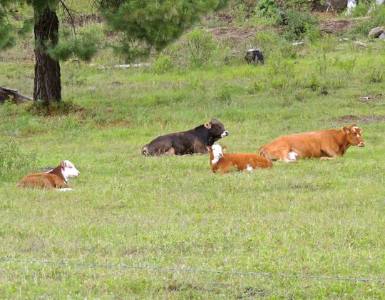
A small herd of cattle relaxed in a meadow across from the bean field. These appear to be Herefords, raised for beef. The breed originated in Herefordshire in England during the 18th century. The breed has spread across most of the world because the cattle are hardy and can stand radically different climates.


The Tipping Rock and the Return


Jim B's moment of triumph. Our goal for this hike was to reach this rock formation, a local landmark. Never one to shrink from an interesting rock climb, Jim scrambled up to see if the rock would really tip for him. It did. After getting my shot, I picked my way to join him. We had learned the route for our hike from our friend John Pint. He writes a column for the Guadalajara Reporter, a weekly English-language newspaper widely read among expats in Jalisco. 

"Crazy Gringos!" A young horseman and his dog both stared up at us while we cavorted on the rock. The horseman struggled to keep a straight face as he climbed on this horse. He and a fellow horsemen had been working just below the rock formation. They soon rode away, no doubt to avoid any disaster should we tip the rock off its supporting boulder.


Best friends forever. Chuck and Matty adore each other. Actually, Matty is quite liberal with her affections. When the two of them show up at a hiking rendezvous, Matty will make her way around the entire group, greeting each person individually.


On the return trail. We retraced our steps to our car, heading down a long slope toward a lush valley. The hike had not been overly strenuous, but the scenery was gorgeous atop the Tapalpa Plateau. It definitely rates a return trip some day.

This completes my posting on our Tapalpa Plateau hike. I hope you have enjoyed the journey as much as we did. If you would like to leave a comment or ask a question, please do so by using the Comments section below or emailing me directly.

If you leave a question in the Comments section, PLEASE leave your email address so I can respond.

Hasta luego, Jim