Showing posts with label Prehispanic sites & artifacts. Show all posts

Saturday, September 13, 2025

Ek Balam Part 3 of 7: The South Plaza's Twin Temples and the Structure 10 ceremonial complex

The nearly identical Twin Temples share a common base platform. The Twin Temples stand side-by-side along the west side of Plaza Sur. Because they are almost mirror images of each other, those who excavated them called them the "Twin Temples", or simply "The Twins". The structure that we see today was built during the Late Classic era (700 AD-1000 AD). However, excavation has revealed structures from earlier periods underneath. Maya rulers usually wanted to surpass their predecessors. Consequently, their architects often built bigger, more elaborate structures over those constructed by previous dynasties. 

In this posting, I will cover the Twin Temples and the large platform called Estructura 10, which stands on the east side of Plaza Sur. These two sets of structures form the upright arms of the "U"-shaped plaza while the Oval Palace, seen in Part 2, forms the base. In addition to showing the photos, I will discuss how these structures were used by the city's ancient Maya inhabitants. For directions to Ek Balam from Valladolid, see Part 1 of this series.


Schematic showing the exterior and interior layouts of the Twin Temples. Despite the name, they are not quite identical. The difference is in the size and positioning of the two sets of stairs. The staircase on the right is very symmetrical with the rest of its temple. The staircase on the left is not quite as wide and is offset slightly to the right of center of its temple. Why the ancient architects built it this way is not clear. The two temples share a platform on their first level. Each temple has two doors and each door leads into two back-to-back rooms. Between them, the two temples have a total of eight equal-sized rooms. 

The interior corridors of each temple form crosses. A person inside a temple would have  access to all four of its rooms without needing to exit the building. Archeologists found a pair of stucco heads, one in each temple (see above). It is possible that the heads may represent the Hero Twins of Maya mythology. The facade of the temples was once decorated with painted figures made from stucco or lime mortar. Ek Balam thus differs from other cities in northern Yucatan, such as Uxmal or Chichen Itza, which were primarily decorated with carved stone.


The Twin Temples, viewed from the left (south) side. The base which the temples share is 40m (131ft) long and 17m (56ft) wide. Each temple is about 6m (20ft) tall. Above the trees in the background to the right is the top of the Acropolis. Just below it is Estructura 8, a part of the ball court. The court is quite close to the Twin Temples and this proximity is probably not coincidental. The Ball Game is a key part of the Hero Twins' myth. Unlike the ball courts at Chichen Itza and Uxmal, there are no mid-court stone rings in Ek Balam's court. However, the Twins have stone rings set in their walls, a possible reference to the game.

What we know of the Hero Twins comes largely from the Popul Vuh. It was a document covertly created by traditional Maya priests after the Conquest. This was during the suppression of Maya religious practices, which the Church denounced as "devil worship". The original Popul Vuh has not survived, but there still exists an 18th century Spanish translation. 

Due to the post-Conquest composition of the original, and possible erros in its translation, the text was long thought to be unreliable. However, when the Pre-Classic civilization of El Mirador was excavated, the carvings on its temples showed the Hero Twins story, just as it was told in the Post-Conquest Popul Vuh translation. 


The Hero Twins' myth involves the Maya Ball Game, maiz, and the Underworld. All these were central to the Maya world-view. The Hero Twins, Hunahpu and Xbalanque, were the sons of Hun Hunahpu, and the nephews of his brother Vucub Hunahpu. The father and uncle were avid Ball Game players, but their noise disturbed the Lords of Xibalba (the Underworld). To stop the racket, the Lords challenged them to a game on Xibalba's court. After the Lords defeated Hun Hunahpu and his brother, they were ritually decapitated. Hun Hunahpu's head was put in a tree, where it was found by Blood Moon, the daughter of one of the Lords of Death.

The decapitated head spoke to Blood Moon and spit in her palm, which impregnated her. When the Lords of Death discovered her pregnancy they decided to kill her. However, she escaped to the world above and went to the house of Xmucane, the mother of the decapitated brothers. Blood Moon told the mother that she was pregnant from Hun Hunahpu, but Xmucana didn't believe her. As a test, Xmucane told her to go to the garden and pick a netful of maiz ears. However, Blood Moon found there was only one plant. So, she magically caused the plant to produce enough ears to fill her net and was then accepted by the mother. 

Blood Moon gave birth to the Hero Twins, who grew up hearing tales of their father and uncle as great ball players. The Twins took up the game, but the noise again disturbed the Lords of Xibalba. Like their father and uncle, Hunahpu and Xbalanque were challenged to play in Xibalba. But first, they had to overcome a series of fearsome tests. In the last test, they burned up in a furnace, but regenerated themselves. This astonished the Death Lords, who demanded that a similar miracle be performed on them. The Hero Twins agreed and ritually killed the Lords of Death, but then refused to resurrect them. After returning to the world above, Hunahpu and Xabalanque rose into the sky, becoming the sun and moon.*

*This is a very abbreviated version of the myth. For a fuller version, click here.


Estructura 10: The Great Platform

A broad staircase leads up from the plaza to the top of Estructura 10s great platform. At the far end of the wall, you can see the north bastion, one of two that protrude from the two ends of the platform's west wall. Estructura 10 faces the Twin Temples across Plaza Sur and forms the eastern side of the plaza. The platform measures 5m (16ft) from the base of the plaza to its broad, flat top.

The platform was constructed in the Late Classic period (700-1000 AD) and is Plaza Sur's largest structure. It seems to have been created for large ceremonies and doesn't appear to have had any residential functions. The only decoration on the platform's walls is a cornice along the top edge made of stones, some of which are as much as one meter in length.
  

Schematic of Estructuras 10, 11, and 12. The rectangular platform measures 43m (141ft) long and 30m (98ft) wide. The dimensions of Estructura 10s platform make it the largest in Plaza Sur. However, it is dwarfed by the much larger structures in the Plaza Norte. Just beyond the top of its staircase is a small altar. On the opposite (east) side of the platform is a one-story temple. On either side of the temple are low, square-shaped mounds of rubble. 

Estructura 10's platform has two associated structures (11 and 12) on its top left (northeast) and bottom right (southwest) corners. These are actually part of the network of walls that connect various buildings that lie inside the two concentric perimeter walls that surround the whole sacred precinct. Estructura 11 connects the platform to Estructura 3, which forms the east side of Plaza Norte. Estructura 12 connects with the Oval Palace (see Part 2 of this series).


Corner of the northwest bastion. Note the size of the wall and the projecting cornice along the top. The architectural influence of the Petén region of northern Guatemala can be seen in the rounded shape of the corner. It must have taken an extraordinary effort to create this platform. First, the ground had to be leveled. Then, baskets of earth were brought to build up the platform from the plaza's surface. Next, thousands of large, heavy stones had to be carried to the site to build the walls. All this was accomplished with human energy alone and without metal tools, wheeled vehicles, or draft animals.


View of the west side of Estructura 10, its southwest bastion, and Estructura 12. The steps you see in the right center lead up to the top of Estructura 12. A sign at Ek Balam describes Estructura 12's narrow wall as "a very peculiar construction which was probably used for ceremonial purposes". The steps allow access to the top of the wall, but there are no stairs leading down the other side. The sign further stated that Estructura 12 was used for ceremonial functions or possibly as a raised space for guards to watch the access points to the site. Estructura 12 was built in three stages, all within the Late Classical period.


Estructura 10: The Ceremonial Complex atop the Platform

Model of a ceremony at a Maya temple. In the scene, the ruler has just arrived on a palanquin, carried by four servants, He is greeted by a trumpeter and various richly dressed nobles and their servants. A woman kneels with an offering at the bottom of the stairs. Near the top left side of the temple, another noble blows on a conch shell. A priest sits cross-legged in front of the small temple's door, awaiting the ruler's approach. The ceremonies conducted at Estructura 10 probably looked very much like this.

I photographed the model above at the Museum of Maya Culture in Chetumal, capital of the State of Quintana Roo, on the Caribbean side of the Yucatan Peninsula. This scene was based on the many stone carvings, painted murals, and other sources of information found at Classic-era Maya sites. It is probably as accurate a representation as could be achieved with our present knowledge of ancient Maya religious and cultural practices.


Just past the top step of the staircase, you can see the small altar and the temple. On either side of the temple are the low rubble mounds. The altar's placement is interesting. Usually altars like this are found immediately in front of a temple, or in the center of a broad space, like this platform. Coming from this direction, the altar faces east, toward the rising sun, the most sacred direction. Thus, rituals could be performed as soon as the staircase was mounted. The proximity to the top of the stairs might be explained by the need for a special ritual upon entering the platform's ceremonial area and prior to crossing over to the temple. 

On the other hand, the opposite direction (west) faces toward the Plaza Sur. The setting sun had other important religious meanings which might have required a different kind of ritual. One thing I have learned about these ancient people is that nothing was done randomly. Everything had at least one symbolic meaning and sometimes several.


The temple is on the eastern edge of the platform, which drops off steeply behind it. Unlike the walls of the platform, the temple was constructed with cut stones. The structure is only one story, but has two levels, with the upper section a bit smaller than the main body. There is only one door, which leads into a narrow hallway. In front of the door is a small stone terrace. The temple was built in the Post-Classic period (1000-1500 AD). Its size and construction are similar to the "miniature temples" found along the Caribbean Coast of Yucatan, where Post-Classic Maya culture once flourished.

I took this shot standing on the low rubble mound to the right of the temple. You can see part of the other mound in the left of the photo. I have found no explanation of the purpose of these mounds. One possibility is that they functioned as reviewing stands. This would have allowed noble spectators to watch processions as they came over the top of the staircase and approached the temple. The mounds may once have been topped by thatch-roofed structures made of wood, so that the spectators could be protected from rain or sun.  


Ancient relief carving of a Maya priest performing a ritual. He is kneeling and carries a censor (incense burner) in his left hand. The burner would have contained fragrant pom (copal incense). With his right hand, he appears to be dropping something into the space below him. The priest's whole posture suggests intense, reverent concentration. Looking at the carving, I could almost hear the rhythmic sound of drums and the mournful tone of a conch shell trumpet echoing in the background.

The figure's clothing and headgear match those of some of the figures in the model from Chetumal's Maya Museum. He wears thick bracelets on each wrist, probably of jade. Suspended on his back is a sort of pack or pouch, possibly used to carry materials necessary for his rituals. While this particular carving is not from Ek Balam, there is good reason to believe that priests looking and acting very much like this performed similar rituals on the platform of Estructura 10 and in its temple.


The temple's door opens into a short, narrow hallway. At the end of the hall is a low altar. This space was probably reserved for rituals which were considered too sacred to be performed in public. Perhaps only the ruler and the very top officials and high priests were allowed entrance. Above, you can see the carefully cut stones used to construct the temple, which are unlike the construction materials used for the platform itself.

This completes Part 3 of my Ek Balam series. I hope you have enjoyed it. If so, please leave any thoughts or questions in the Comments section below or email me directly. If you leave a question, please include your email address so that I can respond in a timely fashion.

Hasta luego, Jim


Saturday, September 6, 2025

Ek Balam Part 2 of 7: The South Plaza's Oval Palace


The Oval Palace (Estructura 16) is the most complex building in Plaza Sur. Both Plaza Sur (South Plaza) and Plaza Norte (North Plaza) are inside the 2 concentric walls that surround the center of the city. The walls restricted access to the sacred precinct where the ruler's family, the aristocracy, and the priesthood lived and worked. Estructura 16 served residential, ceremonial and possibly astronomical purposes. The 5-level pyramid is the second tallest at Ek Balam, after the Acropolis (Estructura 1). The base is rectangular but above it, the sides and rear are curved. So, archeologists dubbed it the "Oval Palace".

Ek Balam had a long history. The area was first settled in the Pre-Classic period, around 300 BC. It was occupied well into the Post-Classic and may have been inhabited as late as the Spanish arrival in the early 16th century. Maya priests told the Spanish that Ek Balam was once the capital of the Tah Kingdom and was founded by a man named Ek Balam (or Coch Cal Balam). Beyond Maya legends, there is no evidence establishing his existence. The height of the city's power occurred in the Late Classic era (770-840 AD), during the rule of Ukit Kan Lek Tok´. He founded the Talol (or Tlalol) dynasty and is an historical figure. 

For directions to Ek Balam from Valladolid, see part 1 of this series.

Overview
Site map showing the various structures within the double perimeter walls. Plaza Sur is the "U"-shaped cluster of buildings near the bottom. The Oval Palace is at the base of Plaza Sur. The left arm of the U is formed by the Twin Temples (Estructura 17) and the right arm by a ceremonial platform called Estructura 10. 

While the the area within the walls is about 1.2 sq km (.75 sq mi), the whole city once covered 12 sq km (7.5 sq mi). Serious archeological digs at Ek Balam only began in the 1990s. Since then only about 10% of the overall city has been excavated. Almost all of that has been in the sacred precinct, but even in that area, there is still much to be discovered.  Estructura 2, the very large mound of rubble on the west side of Plaza Norte, has had almost no excavation. About 1/3 of the Acropolis is still un-excavated.


Sacbé 2 leads to a ceremonial gate on the south side of Ek Balam. Sacbé translates as "white road". Sacbeob (the plural) are raised roads paved with lime. Some of them were scores, or even hundreds, of kilometers long. The square gate sits on top of three stepped levels, with arched entrances on all four sides. The east and west sides have steps, while the north and south sides have ramps. Above, I am standing on the east side stairs. This gate is the most important of the five entrances to the perimeter walls. Spectacular processions once passed through here, including religious parades and visits by neighboring rulers. 

The four arches are believed to be associated with the four cardinal directions, which were very important to ancient Maya architects. In fact, the orientation of all the structures within the sacred precinct follows this pattern. Usually the most important directions in Maya cities (and elsewhere in Mesoamerica) are east and west. That is the path the sun takes from its rise to its setting. However, north and south are the most important directions at Ek Balam. For example, processions entered this gate from the south, and the Oval Palace faces north. It is not clear why the city's rulers and their architects made this unusual choice. 

The Oval Palace

The front of the Oval Palace, viewed from Plaza Sur. The rectangular base has 10 rooms, located on three of its sides. Two of the doors to these rooms can be seen above, one on either side of the bottom of the stairs. The second level has one room on either side of the staircase. The stairs narrow as they rise to the top level, which contains a small temple. The curved sides and rear of the upper levels indicate that the Oval Palace's temple may have been used for celestial observations. Similarly curved structures, like the one at Chichen Itza called "the Observatory", are believed to have been used for astronomical purposes.

The Tah dynasty, founded by Ek Balam ("Black Jaguar"), was followed by a dynastic family called Cupul. Again, it was centuries later that Maya priests recounted this story to early Spanish investigators. How and why this change in dynasty happened is unclear and it may only be a legend. What we do know for sure is that the architecture here is a mixture of ancient styles, including Petén (Guatemala's lowlands), Chenes and Rio Bec (southern Yucatan Peninsula), and Puuc (northwestern Yucatan). Architectural style changes usually came about through trade contacts or foreign dynastic takeovers (peaceful or otherwise). 


View of the Oval Palace from the southwest. Above, you can see the curved sides of the upper levels, as well as the doorways of four of the ten base-level rooms on the west and south sides of the building. The low wall in the foreground is not part of the two concentric perimeter walls. In addition to the outer ring walls, there are several others that connect structures within the sacred precinct, further inhibiting access to any but the elite. The wall above connects the  Oval Palace with the entrance arch.

Unlike Mesoamerican civilizations like Teotihuacán, the Toltecs, or the Aztecs, the Maya were never unified in what might be described as an "empire". Instead, their world was a collection of warring city-states, more like that of Classical Greece. The more powerful states did exert influence over lesser city-states, but this was always a very fluid situation. During Ek Balam's long history, it was a contemporary of many famous Maya city-states, like Edzna, Uxmal, Chichen Itza, and Mayapan. In fact, the architectural styles at Ek Balam appear to have influenced other cities, Chichen Itza in particular.


Interior of one of the rooms. Rooms in ancient Maya elite architecture tend to be long and narrow. The ceiling were constructed as "corbel" vaults. They were not true arches, which Maya architects never mastered. As you can see above, a corbel vault gradually narrows as it approaches the center of the ceiling. Notice the blackened wall at the end of the room. This was probably the result of innumerable cooking fires over the centuries. Food would have been prepared on a griddle called a comal, supported by a trio of rocks with an open fire underneath. Lacking a chimney or windows, the room would have been pretty smokey.

Although the room above looks pretty bleak today, it would once have contained a colorful array of cloth goods, pottery, and other furnishings. The cloth would have been made from cotton  in a variety of colors using mollusk dyes and decorated with embroidery, feathers, and pearls. Beautifully woven baskets would have been placed on the floor or suspended from cords of maguey fiber. Pottery was used for daily needs but also for display. In noble houses, it would have been artfully crafted and richly decorated with paint. 


Ceramic censer used to burn copal incense during various rites and ceremonies. This lovely little piece was crafted with a long handle that ends in a snake head. It is not only a functional object but also highly decorative. The openings around the bowl's sides allow the free flow of air to keep the copal burning. I found this piece among other artifacts in the San Roque Regional Museum in Valladolid. There is no on-site museum at Ek Balam, so the one in Valladolid is the best local place to find such artifacts.

Copal sap was used by the ancient Maya and other Mesoamerican civilizations for thousands of years. Many modern indigenous shamans still use it. The word copal comes from Nahuatl, the language of the Aztecs. The Maya called it pom and considered the sap to be "the blood of trees". They believed that when the sun, moon and stars arrived on earth, they brought pom with them. The sap is collected from the tropical Buerseraceae (torchwood) plant. Copal/pom was not only used for incense, but as a binder for pigments in Maya murals, for making jewelry with the "lost wax" technique, and as chewing gum.


Some of the rooms have raised platforms for sleeping or sitting. The platforms would have been covered by reed mats and cloth for comfort and warmth. Only the elite lived in rooms like this. The commoners would have lived in mud-and-wattle huts with thatched roofsoutside the sacred precinct. Most of the daily life for both nobles and commoners would have occurred outdoors, except during inclement weather. The various terraces, platforms and steps of the structures within the sacred precinct would have been where the nobles spent their leisure time socializing with one another.

Maya nobles were known as almehenob and filled a variety of roles. These included priests, government officials, court officers, scribes, tribute collectors, military leaders, and administrators. Their positions were hereditary and there were strict distinctions between the nobility and the commoners. These included not only Ek Balam's perimeter walls, but skull deformation of children so that nobles actually looked different than commoners. A noble's diet was similar to that of the commoners, but included more meat and special foods. They drank chocolate, (KaKaWa (cacao)) a beverage too expensive for the lower classes.


View of Plaza Sur and the Twin Temples from one of the Oval Palace's front rooms. The Twin Temples are on the immediate left, while Estructura 8 (part of the ball game court) can be seen in the distance. Beyond the trees in the distance are Plaza Norte and the Acropolis (Estructura 1). Rooms in ancient Maya architecture seldom had windows, so the only natural light is through the door. Consequently these interior spaces would have primarily been used at night or during inclement weather or when some level of privacy was required.

The Oval Palace was built during the rule of Ukit Kan Lek Tok´, apparently as a residence for his nobility. He built the Acropolis in Plaza Norte for himself. It is not clear whether the Oval Palace was constructed before or after the Acropolis. If it was before, he might have used it as temporary housing while supervising the work on the massive palace complex that became the Acropolis. If celestial observation was part of the function of the temple on top of the Oval Palace, it is likely that some of the residents were priest-astronomers. One of their key responsibilities was using the stars to predict planting and harvesting times.


The bones of a child were found during excavation of the Oval Palace. They had been placed in a vase or pot and then covered by a plate. The careful treatment of the remains suggests that they were not part of a sacrifice, although child sacrifice was not uncommon in Mesoamerica. Instead, it is likely that this was the child of one of the elite families living in the Oval Palace.  In addition, the condition and arrangement of the bones suggests this was a secondary burial, meaning the child was buried somewhere else first and then the bones were de-fleshed and re-interred in the Oval Palace.

In the Maya world, elite tombs were usually placed inside temples or other important buildings. Therefore, it would not be unusual to find this child's remains within the Oval Palace. Sometimes, the bones of one person would be moved aside so that another set of remains could be buried in the same tomb. In a later posting, I will show you the spectacular tomb of Ukit Kan Lek Tok´, located on the fourth level of the Acropolis.


Metate, mano, and other tools of daily life. The metate is the stone trough in which maiz (corn) was ground using the roller-shaped mano. The two stone objects near the base of the metate appear to be cutting tools. A bone awl is to the right of the the cutting tools. Maiz was fundamental to ancient Mesoamerican life. It was domesticated from a wild plant called teocinte (or teocintle) about 9,000 years ago. This probably occurred in the Valle de Rio Balsas, in the modern state of Guerrero, Mexico. Maiz was first cultivated by the Maya about 6,500 years ago. 

Large scale maiz production enabled the development of a high level of civilization in Mesoamerica. The grain was inextricably intertwined with all aspects of life, culture, myths and religion. In fact, maiz had its own god, called Hun Nal Yeh (or, alternatively, Yum Kaax). In contrast to some of the other gods, he was portrayed as youthful, smooth faced, and vigorous. He also ruled the forests that surrounded the Maya city-states and represented abundance and prosperity. All this made the maiz god an important figure in the Maya cosmos.

The completes Part 2 of my Ek Balam series. I hope you have enjoyed it. If so, please leave an thoughts or questions in the Comments section below or email me directly. If you leave a question, please include your email address, so that I can respond in a timely manner.

Hasta luego, Jim


Sunday, August 31, 2025

Ek Balam Part 1 of 7: An ancient Maya metropolis in northern Yucatan


An exquisitely carved statue decorates the tomb of one of Ek Balam's rulers. The statue wears the attire of a highly-placed member of Ek Balam's Classic-era aristocracy. The jewelry on the wrists and ankles represents jade, one of the most precious stones of the ancient Mesoamerican world. The necklace and ear spools would also have been jade. The upper body is naked except for an elaborate head dress and a feathered cloak which spreads out from the shoulders. The mid-section is covered by a garment resembling an embroidered kilt.  Hanging over the groin is a pouch decorated with a grinning face.

This posting is the first of a seven-part series on the ancient Maya city of Ek Balam ("Black Jaguar"). The ruins are less than 1/2 hour drive north of Valladolid and we visited them during our stay there. However, since Ek Balam can also be easily reached from Cancun or Mérida, I decided to present this as a stand-alone series. Part 1 will be an overview of the major features of the city, while the following six parts will show each of these features in detail.

Overview

Google map showing the route from central Valladolid to Ek Balam. The distance from Vallolid's central plaza to the ruins is 27.8km (17.2mi). Proceed north on Highway 295 about 20km to a right-angle intersection with a small hotel on the corner. About 100m before this intersection there is a large sign on the right which points toward Tizmin and Rio Lagartos, but makes no mention of Ek Balam. Be alert for this intersection with its hotel when you have traveled approximately 20km from Valladolid

About 100m after you turn right, there is a sign pointing toward Z. A. (Zona Arqueologica) Ek Balam. After about 5km, you come to a four-way intersection. A left takes you to the modern pueblo of Ek Balam, while a right goes to the pueblo of Santa Rita. Instead, head straight into the Zona Arqueológica. Follow the road about 2km to the large parking area. A short trail from there will take you to the beginning of the ruins. 


One of several iguanas that we encountered in the ruins. While I am not certain, this may be one of the Black Spiny-Tailed species (Ctenosaura similis). The Yucatan Peninsula and Central America abound with many different iguana species. The ones I have encountered are almost always totally unconcerned by the approach of humans. They usually remain completely still while I take my photo, almost as if they are posing. Despite their languid appearance, this species is the fastest lizard on the planet and can reach speeds of 21mph, if threatened. They like places where they can bask or hide in rocky crevices, if frightened.


The mouth of a chultun, which once stored water for Ek Balam's inhabitants. I found it near the Acropolis (Estructura 1). A chultun  is a man-made water storage chamber shaped like a globular pot with a neck that narrows to a circular opening at ground level. Chultunes were carved into the thick limestone sheet which lies just below the soil. The opening for this one looks big enough for a man to squeeze through and then move around inside. Once carved into the desired shape, the inside walls were made watertight with lime plaster. 

Northern Yucatan has no natural water sources other than rainfall and the limestone sinkholes called cenotes. To solve this problem, chultunes were invented by ancient Maya hydraulic engineers to help expand the available water supply. Rain running off nearby structures was channeled to an opening like this so that the water could be stored for use in dry periods. Smaller chultunes had a capacity of 7,500 gallons (enough for 25 people). Some were much larger, however, with capacities ranging from 16,000 to 110,000 gallons. 


A Maya welcoming committee, as they would have appeared in the early 16th century. 
Unlike the statue in the first photo, the men above are warriors, dressed for battle, not for style. They are naked except for loincloths and light capes over their shoulders. Two of their capes are fringed with large animal teeth, possibly jaguar fangs. The two warriors on the left carry wood-handled weapons, set with razor-sharp obsidian blades. All four are decorated with intricate tattoos (possibly temporary), which symbolize strength, spiritual power, social status, and possibly membership in a warrior clan.

The first Spanish encounter with the Maya was peaceful. In 1502, one of Christopher Columbus' ships encountered a large, sea-going Maya canoe in the Caribbean Sea. However, when the Spanish began exploring the coasts of the Yucatan Peninsula in 1517, they met fierce resistance. Serious efforts to conquer Yucatan did not begun until 1542, twenty years after the conquest of the Aztecs. The last Maya stronghold did not fall until 1697. The Aztecs managed to hold out for about 2 years, but the Maya lasted for 180! Sporadic revolts in the Yucatan continued over the centuries, including the 67-year Caste War, which ended in 1915.


The elite ceremonial precinct of Ek Balam. This area is surrounded by two concentric sets of low walls with five entrances. There is one each on the north, east, and west sides and two on the south side. Leading to each of these entrances is a sacbé ("white road") paved with stones covered with white lime plaster. Sacbé #2 is 10m (33ft) wide and extends 190m (623ft) out from its gate. Originally, it may have been much longer. The longest sacbé in Yucatan reaches 300km (186mi) from Mérida to the Caribbean Coast. The intersection of  five sacbeob with Ek Balam is an indication of the city's political and economic power. 

A total of 45 of the city's structures have been excavated. The most important of these surround Plaza Norte (North Plaza) and Plaza Sur (South Plaza). In the map above, the Plaza Norte is shaped like an inverted "U". It is bounded on the north by the Acropolis (Estructura 1), on the west by Estructura 2, and on the east by Estructura 3. The smaller Plaza Sur is also "U" shaped (but not inverted). The Oval Palace (Estructura 16) is at its base (south side). The west side is bordered by a pair of structures called the Twin Temples (Estructura 17). The east side is formed by a large platform called Estructura 10.


Perimeter Walls and Main Entrance

Sections of the inner and outer walls. The Sacbé 2 entrance arch is in the upper left. The Oval Palace can be seen in the upper right. Archeologists have long debated the purpose of these walls. Originally, they were thought to be defensive structures and are still described this way in some tourist publications. However, although they are thick, they were never much higher than what you see above. Such low walls would not have been of much use in warding off determined attacks.

Modern archeologists now believe that the purpose of the walls was to establish boundaries and restrict entrance to the areas reserved for the city's rulers, nobility, and priesthood. The general the population would have lived in thatched huts called "nah", spread out widely over the area outside the walls. 


The main entrance (Estructura 18) to Ek Balam is through this ceremonial arch. It sits on a three-tiered platform and is approached from the Sacbé 2 by ascending the ramp seen above. A similar ramp on the north side leads down into the ceremonial area. The east and west sides also have arches, but these are approached by stairs. The architecture of this structure indicates that it was the main ceremonial entrance to the city.


View of the Sacbé 2 entrance (Estructura 18). I took this shot looking southwest from the top of the Twin Temples. Here, you can see both the ramp on the north side, as well as the east-side arch and its stairs. Although this is not one of the larger structures in Ek Balam, its unusual architecture makes it one of the most photographed. In the center left background, you can see a bit of the outer perimeter walls.

Plaza Sur

The Oval Palace (Estructura 16), viewed from the top of the Twin Temple. The structure gets its name from the sides and back of its second level, which has a the curved, oval shape. This is an elite residential building, rather than a temple, although some ceremonial activities are likely to have occurred here. An impressive staircase leads from the Plaza level up to the top of the platform, which contains a small structure. Some archeologists speculate that the Oval Palace may have had an astronomical, as well as a residential, function. There are similar curved structures at other Yucatan sites such as the "Observatory" at Chichen Itza.


The Twin Temples (Estructura 17) form the west side of Plaza Sur. These two temples face east across the Plaza toward Estructura 10. Because they are nearly identical in size and design, archeologists decided to call them "The Twins". Each of the two temples sits on a two-level platform accessed by broad staircases. Each temple has two doors and each door leads into two rooms, one behind the other, giving the Twins a total of eight rooms.

These rooms don't appear to have served as living spaces but were more likely used for religious and ceremonial purposes. Archeologists believe the Twin Temples may be related to the Hero Twins of Maya mythology. The Lords of Death in Xibalba (the underworld) challenged them to a ritual Ball Game. The Hero Twins were triumphant and, after overcoming a variety of other challenges, they were transformed into the sun and moon.


Estructura 10 faces west, toward the Twin Temples. The base of this structure is a huge, raised platform which makes up the eastern border of Plaza Sur. It is accessed by a broad staircase on its west side. A small altar is on top of the platform, near the top of the stairs. On the far side of the platform is a small temple (see above) containing another altar. The temple is flanked by two long, low, rubble mounds. 

While the little temple and the low mounds are not impressive on their own, the platform on which they sit is the largest of Plaza Sur's structures. Estructura 10 was clearly intended for large ceremonies and rituals, rather than for living quarters. The large space on top of the platform would have accommodated a sizable crowd. It is possible that the mounds served as raised viewing ares for elite spectators, sort of like the viewing stands on either side of a modern playing field.


South and east sides of Plaza Norte

The Ball Court sits a few yards to the north of the Twin Temples. Its proximity to the Twin Temples is probably not coincidental, if the archeologists are right about the Hero Twins myth. Ek Balam's Ball Court is made up of Estructura 8 (right) and Estructura 9 (left). The playing field includes the sloping areas on each structure and the narrow, rectangular space between them. 

Some ball courts, like the one at Chichen Itza, were fitted with a stone ring half-way down each side of the court. However, there are no stone rings in this court. While the game was played for thousands of years, all over Mexico and Central America, the rules differed from place to place and sometimes didn't include the rings.


The east side of the Plaza Norte is bordered by Estructura 3. This is the second largest structure at Ek Balam, in terms of the space covered. Only the Acropolis (Estructura 1), on the Plaza's north side, is larger. Estructura 3 is a low platform, measuring 110m long and 55m wide (361ft X 180ft). It is accessed by a small, 5-step staircase on its west side. In front of the stairs is a standing, two-sided rock called a stela. Sometimes a stela contains images or glyphs, but this one is unmarked. The ruins of a small temple stand in the center of the platform. Etructura 3 was likely for ceremonial rather than residential purposes.

Estructura 3 was first excavated in 1886 by the French explorer Desiré Charnay . He found "a severed head modeled in stucco with the fragments of an inscription." Charnay dug around, looking for a tomb, but found only fragments of decoration and parts of a black-painted clay figurine. More recently, archeologists found a stucco mask which may be the severed stucco head that Charnay reported. The west side of the Plaza is bordered by Estructura 2, which I didn't photograph because it was almost entirely un-excavated rubble.
  

North side of Plaza Norte

The Acropolis (Estructura 1) is the largest building in Ek Balam. It was built as a palace during the Late Classic era by the city's most powerful ruler and contains his tomb. A single, broad staircase leads six levels up to the top of the structure. Each level contains multiple rooms, some with intricate glyphs and other decorations. The tomb is decorated with exquisitely-carved stone statues of rulers and other aristocratic figures (see first photo). Some of the statues were deliberately decapitated centuries ago, probably when the city was captured by enemy forces.


A tourist carefully descends the Acropolis' wide staircase. While the steps are wide across, they are also very narrow. This makes them somewhat dangerous, particularly when descending. Over the years tourists have occasionally been injured or even killed from falls down stairs like these. Once you start to tumble, it would be very difficult to stop yourself. 

As a result, the Mexican government has prohibited climbing on some ancient ruins, including the stairs of the famous El Castillo, or Pyramida de Kukulkan, in Chichen Itza. Fortunately, these prohibitions were not in place when we visited Ek Balam, although this may since have changed. If you are fortunate enough to be able to climb up a pyramid or temple, please be extremely careful, particularly when descending.

This completes Part 1 of my Ek Balam series. I hope you have enjoyed it. If so, please leave any thoughts or questions in the Comments section below or email me directly. If you leave a question, please include your email address so that I can respond promptly.

Hasta luego, Jim


Thursday, February 13, 2025

Valladolid Adventures Part 1: A jewel among Yucatan's treasures

Statue on the central fountain of Parque Principal Francisco Cantón Rosado. She is called "La Mestiza" (meaning mixed Spanish and Maya) and wears an embroidered huipil, the traditional garb women in Yucatan. Manuel Cachón sculpted the statue in 1924. His original work was replaced for a time by a monument to the heroes of June 4, 1910, who ignited the Mexican Revolution. Eventually, that monument was itself replaced by this replica of the original. La Mestiza's smile epitomizes the friendly, laid-back local attitude.

In Part 1 of my Valladolid Adventures series, I will do something a little different from my past practices. I intend to briefly highlight some--but not all by far--of the fascinating things to see and do in this small city in central Yucatan. Each of these places will be covered in some depth in future parts of the series. My future postings will also cover nearby places we visited on day-trips outside Valladolid. These will include Maya sites like Ek Balam, Cobá, and Muyil, and the great colonial-era monastery at Izamal. If the Yucatan Peninsula is a treasure chest of experiences, Valladolid shines as one of the brightest jewels.

Overview

Google map of our route from Mérida to Valladolid. In January of 2017, we flew into Mérida from Guadalajara, and rented a car at the airport. We stayed the night at a nearby hotel so we would be fresh for our drive the next morning. It is a pretty straight-forward route. You head south on the highway from the airport and look for signs for the Mérida Periferico and Cancun. Once on the Periferico, you travel for 19 km (11.8 mi) or 20 minutes. Turn right at the exit for Cancun, onto the autopista Highway 180. (Alternatively, you could fly into Cancun and drive from there to Valladolid, about the same distance.)

The Highway 180 autopista (high-speed toll road) should be in excellent condition. Follow 180 for about 2 hours until you come to the exit on the right for Valladolid. From the exit, drive 5.6 km (3.5 mi) south along Highway 295 to Parque Principal in the center of the city. We stayed at Hotel Mesón Marquis, which faces the Parque's north side. There are other good hotels in Valladolid, but we chose this one because it was central and within walking distance of nearly everything we wanted to see. For a Google interactive map, click here.

Parque Principal Francisco Cantón Rosado

The fountain of La Mestiza is surrounded by a circle of benches. Walkways radiate out from the path around the circle. Through the trees on the south side of the Parque, you can see the bell towers of Templo San Servacio, Valladolid's main church. Although the Parque is generally fairly serene, there was a colorful fiesta during part of our visit, with booths selling a variety of handicrafts. In the next posting of this series, I will give you a taste of this vibrant event.

The Parque Principal stands in an area once covered by a Maya pyramid that was 100 m2 (109.3 yds2). Following the usual Spanish practice, the pyramid was demolished and its materials were used to build the City Hall, mansions for the conquistadors, and an earlier version of the Templo San Servacio, . The space left by the removal of the pyramid became Plaza de Armas, so-named because that was where the colonial militia met to drill. In 1900, the plaza became Parque Principal Francisco Cantón Rosado, named for the Governor of Yucatan who donated the fences surrounding the Parque

Templo San Servacio

The church resembles a fortress because it occasionally functioned as one. Notice the high walls and three vertical gun slits on each tower, placed there to be used during periodic Maya revolts. Since the Maya refused to stay conquered, the Spanish buildings had to be defensible. As mentioned above, the original church was built from materials looted from the pyramid of Zaci. That was the name of the people living in the area when the Spanish arrived. After the conquistador Francisco de Montejo el Sobrino defeated them, he named his new city Valladolid, which was the name of the city that was then capital of Spain. 

As I mentioned, the church above is not the original Templo San Servacio. That structure was demolished in 1705 on the order of the bishop, Don Pedro de los Rios Reyes, "to help erase the stain" of a crime that had been committed on its premises. In a future posting, I will detail how it was that the church came to be rebuilt in its present form. Visitors to my blog may have noticed that I spend a lot of time photographing and talking about religious structures like this one. I am not a religious person myself, but I do admire the artistry and cultural significance of Mexico's colonial heritage, as well as its pre-hispanic heritage. 

Hotel Mesón de Marques

Courtyard and swimming pool of our hotel. I took this shot from the balcony just outside of our room. This hotel was one of the nicest we have stayed at during our time in Mexico. The location of the hotel was ideal for exploring the city on foot. The staff were friendly, efficient, and helpful. One of the best aspects was the restaurant, located around another courtyard, where we ate most of our breakfasts and dinners. The food was delicious, reasonably priced, and the service was excellent. A future posting will cover this very special hotel.

The Méson de Marques (Mansion of the Marquis), was built in the 17th century for a high-level member of the Spanish aristocracy. In colonial times, the most important members of the local community built their homes facing the main plaza of a city, or along streets adjacent to it. The further out you lived, the lower your social status. The indigenous people lived on the outskirts and provided the cooks, maids, gardeners, and other servants of the wealthier classes. All this didn't happen by accident. It was the result of deliberate colonial urban planning dictated by Spanish King Phillip II in the last part of the 16th century. 

Ex-Convento San Bernardino de Siena de Sisal

View of the Ex-Convento from the right. The distant figure in the center is Carole. Construction on this Franciscan ex-convento (now a museum) began in 1552 and was completed in 1560. That's quite a rapid pace for such a large structure. In fact, it is the second largest Franciscan construction in Yucatan, covering 14,121 sq meters (15,442 sq yds). Included in the complex are the church, cloister, chapel, and orchard. The ornate retablo behind the church's main altar is particularly notable. Given the size of the complex, I will probably do more than one posting on it later in this series.

For those who viewed my recent series on the Franciscan convents in the Sierra Gorda, you will recall that the Franciscans played a major role in Mexico during the so-called "Spiritual Conquest". Some of the young Franciscans who worked in the Sierra Gorda ended up in leadership positions in the Yucatan missions later in their lives. That the Yucatan's two largest conventos were both Franciscan shows the significance of the Order's role here. Ex-Convento San Bernardino de Siena is located about 7 blocks southwest of the Parque.

Cenote Zaci

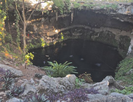
Cenote Zaci is a deep, shady, water-filled pit in the limestone crust of Yucatan. The small floating objects in the water are swimmers. The figure dressed in red by the tree on the left provides a sense of scale. Cenote Zaci is open from 8:30am to 5:30pm with a modest entrance fee of 30 pesos ($1.50 USD). There are changing rooms and restrooms as well as an adjacent restaurant. Lifejackets are also available. Only a few of Yucatan's cenotes are located so conveniently within a town. This one is just 4 blocks northwest of the Parque Principal

Cenotes are found throughout northern Yucatan and were the main water source for the ancient Maya civilizations that developed here. Including Cenote Zaci, Valladolid has at least two cenotes within blocks of where the Zaci pyramid once stood. Most of Yucatan is a flat, porous limestone shelf. Rainwater seeps down into it to form underground pools. The crust over some of these pools eventually erodes and collapses, leaving an open pool. The meteor that struck the coast of Yucatan 60 million years ago not only killed all the dinosaurs but created a series of concentric cracks in the limestone which helped create the cenotes.


Museo Regional San Roques

Ancient Maya stucco mask. The facial features include a rounded, chubby face, thick lips and a flattened nose. These give the mask an uncanny resemblance to those on the great stone Olmec heads found in the State of Veracruz. The Olmec heads were found hundreds of miles away from Valladolid, and their civilization died out at least 1000 years before this mask was made. I therefore found the resemblance very odd. I would be open to hearing from anyone who can enlighten me about this. The mask, along with other Maya artifacts, are displayed in the Museo Regional San Roque, about 1 block east of the Parque Principal. 

The site of the museum has a long and colorful history. It was originally a 4-bed hospital, founded as Hospital del Santo Nombre de Jesus in 1575 by Valladolid Mayor Don Diego Sarmiento de Figueroa. This evolved into the Convento de San Roque and by 1645 the hospital was the best in the province. All this has long since disappeared except for the temple to San Roque. Several historical figures are buried under the museum's courtyard, including those killed in the crime that resulted in the demolishment of the Temple of San Servacio, as well as activists executed at the beginning of the Mexican Revolution.

Iglesia Santa Ana

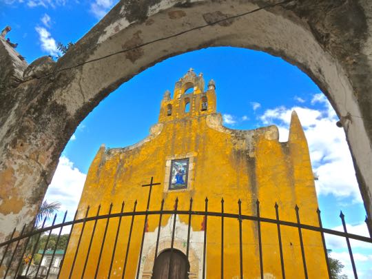
Iglesia de Santa Ana, seen through one of the triple arches of its front gate. This small 16th century church was originally built for the Maya natives. At that time, all services except mass were conducted in their language. Santa Ana, the church's patron, is said to be the mother of the Virgin Mary. These very early colonial structures represent a world very different from today's modern, bustling Mexico. The structure still functions as a church after 500 years. I very much appreciate the effort Mexicans take to preserve their heritage. A future posting will take a closer look at the church, both inside and out.

Part of the open space in front of the church, called the atrium, later became a neighborhood park. It was in this park that Manuel Antonio Ay was hanged on June 30, 1847. He was an early leader of the Caste War (1847-1915), a great Maya revolt that nearly drove the Spanish out of Yucatan. Today the park contains a monument to Los Heroes Niños (the Child Heroes), commemorating the cadets who died fighting the U.S. forces that had invaded Mexico in 1846. Several young cadets died defending Chapultepec Castle. One of them, rather than surrender, wrapped himself in the Mexican flag and jumped off the high parapet.

Hacienda San Lorenzo & Cenote Oxmán

The casa grande of the hacienda has been transformed into a a hotel. Hacienda San Lorenzo was constructed in 1746. There is very little information available about its early history, some sources suggest that this hacienda may have grown agave for mezcal, a liquor similar to tequila. Distilling these liquors became important in the last half of the 18th century, so production soared. In addition haciendas in this area produced corn, cattle, and sugar. Sisal, a plant native to Yucatan, was also grown at many 19th century haciendas in north central Yucatan. It was used for twine to bale wheat sheaves and for rope to rig ships. 

The hacienda has the advantage of possessing the Oxmán Cenote, one of at least two within Valladolid. This was fortunate for the original hacienda owners because there are no rivers and very little above ground water in northern Yucatan. Lack of water inhibited crop production of any but drought-resistant plants like agave and sisal. The cenote here is very similar in size and shape to Zaci Cenote. Like at Zaci, you can swim here and there were several people in the water when we visited. As you can see above, the casa grande's pool was empty, so the experience of diving into the Oxmán Cenote must have been captivating.

Centro Artesanal Zaci

Zaci's handicrafts center faces the Parque Principal, on its north side. The Centro Artesenal Zaci stands next to Hotel Mesón de Marques on its west side. It was once a the mansion of a conquistador, but it later became part of the Casa Cural (parsonage or priest's house). 

Refurbished in the 19th century, the building housed the Model Central School in 1906 and the Military Exercises Professorship in 1908. The Bolio family owned the property as a private home for a time, but in 1940 it again became a school named after local luminary Delio Moreno Cartón. In 2007, the school was moved and the Valladolid Administration opened the Centro Artesenal Zaci. (Photo from En-Yucatan website)

Casa de los Venados

"Hi! What's up? Come on in and relax!" A scary skeleton, with a somewhat off-putting expression, greeted us when we arrived at Casa de los Venados (House of the Deer). This is the home of Mr. and Mrs. John Venator, who own Mexico's largest private collection of folk art. Over 35 years, they gathered more than 3000 items, including some of the most extraordinary I have yet encountered. After we made the expected donation of $100 pesos ($5.00 USD), our Mexican guide Freddy showed us around the place. Neither the Venators nor Freddy had any problem with the considerable number of photos I took. 

John Venator retired to Yucatan after a career as a CEO of an international trade organization in Chicago. He and his wife looked at various places in both Mérida and Valladolid before buying this 18,000 square foot property. It has become both their home and their private museum. The house was largely in ruins when they purchased it, but they remodeled it over 8 years, first for vacations, then as their retirement home. Casa de los Venados is 1/2 block south of the Parque Principal. They share it with a small terrier who loves to sit on John's lap. Whatever else you decide to see in Valladolid, don't miss a visit to this place!

This completes Part 1 of my Valladolid Adventures series. In Part 2, I will show you around the Parque Principal and the colorful fiesta we encountered there. I hope you enjoyed this first part. If so, please leave any thoughts or questions in the Comments section below or email me directly. If you leave a comment, please remember to include your email address so that I can respond in a timely manner.

Hasta luego, Jim