
This posting was originally intended as the first of a three-part series, including ruins of the cities of Peralta and Cañada de la Virgen. I visited and photographed all three sites several years ago. Unfortunately, a hard drive crash wiped out the photos of the other two cities, leaving me with only those from Plazuelas.
The three cities are all located in a region of central-western Mexico known as El Bajio (The Lowlands). Until the late 20th century, archeologists thought the area contained few if any ancient ruins. They couldn't have been more wrong. In order to understand the role played by Plazuelas and the other cities, it is first necessary to talk about El Bajio.
Overview

As a result, the region came to be known as the Gran Chichimeca. Both the Aztecs and the Spanish considered it to be empty, dangerous, and of little value. That had been El Bajio's reputation for the previous 600 years. However, in the Pre-Classic era (400 BC-250 AD), the area had contained numerous settlements of a culture known as the Chupicuaro. This was enabled by rich lands well-watered by the Lerma and Laja rivers.
During the Classic era (250-600 AD), El Bajio's population grew rapidly. Cities of significant size with sophisticated architecture began to appear. Defensive fortifications also appeared, indicating the presence of hostile forces. Teotihuacán was the dominant power in this era, and architecture and cultural artifacts have been found in many places. Then, around 600 AD, the great trading empire of Teotihuacán fell, possibly from an internal uprising. This ended the Classic era and began the Epi-Classic.
El Bajio really came into its own during the Epi-Classic (600-900 AD). During that era, regional powers sprang up all over Mexico to fill the political and economic vacuum left by Teotihuacán's fall. These included cities like Xochicalco, Cacaxtla, and La Quemada. El Bajio was important because the trade routes of these far-flung regional powers all ran through it. This was of great advantage to the growth and development of Plazuelas.

The Epi-Classic was a period of conflict and militarism among the regional powers, as is usually the case after the fall of great empires. An example of this can be found on the huge mural of a gory battle at the city of Cacaxtla. As a consequence, all of the Epi-Classic cities I have visited occupy carefully planned defensive positions. At Plazuelas, the cliffs and ravines would have provided a considerable advantage to defenders and greatly hindered those who might attack.
While Plazuelas' position in El Bajio was advantageous for trade, it also involved disadvantages. Envious powers might attack, seeking to control its trade routes. In addition, numerous Chichimeca migrations from the north had occurred over the centuries and Plazuelas was squarely in the path of these invasions. At the end of the Epi-Classic, the city was sacked, burned, and abandoned, apparently as the result of one of these threats.

Along trails worn by centuries of footsteps, the merchants trudged into Plazuelas from the north, west, east, and south. They were usually accompanied by lines of heavily laden porters, since baggage animals didn't exist in Mexico until the Spanish arrival. The porters carried beautifully painted ceramic pots, bowls, and plates, all carefully cushioned in wood-frame packs. These were crafted in the workshops of cities throughout Mesoamerica.
Also to be found in those packs: turquoise from the deserts of the American Southwest; conches and other seashells from the Pacific Coast; obsidian from the mines of Jalisco; jade from the Motagua Valley of Guatemala; Quetzal feathers from the rainforests of today's Chiapas; and bundles of cotton and sacks of cacao beans from the sultry plains of the Gulf Coast. These were some of the most valuable trade goods that passed through El Bajio.

North of the Ball court is the large platform called Casas Tapadas (Covered Houses), the political and ceremonial center of Plazuelas. The platform measures 149m x 88m (490ft x 290ft) and contains five large structures. These are surrounded by a low wall which, along with other walls, form several large sunken patios, a typical feature of El Bajio architecture. Viewed from the south, the platform mirrors the hills behind it, a deliberate strategy of the ancient architects. A stone sculpture of a feathered serpent with a human face emerging from its mouth was discovered near the platform's west side.
The platform's main entrance is a staircase on its west side. The first structure you encounter is a square, roofless structure called the Recinto (enclosure). On either side of the Recinto are the north-facing pyramid-temple designated #1 and the nearly identical south-facing #4. In the center of the platform, about 10 meters behind the Recinto, is pyramid-temple #2, called Casa de los Caracoles (House of Snails). About 20 meters behind #2 is pyramid-temple #3, the Basamento Oriente.
Juego de Pelota

Serpent sculptures were found in each of the four corners of the playing area. In addition, the museum contains a large stone sculpture of a Feathered Serpent that was used as a marker on the playing field. The feathered serpent was one of the most important gods in Mesoamerica and, along with the ball game itself, dates all the way back to the Olmecs (1400-400 BC). Plazuelas' court had no stone rings attached to its side walls, unlike some others in Mesoamerica.

In addition to its religious functions, the Ball Game was also used to settle disputes between factions within a city, or even between two different cities as an alternative to war. Little is known about the pre-hispanic rules, but in general the ball was propelled by the hips rather than the hands or feet. Other specifics differed from place to place. Rubber balls as heavy as 4kg (9lbs) could cause injuries or even death, so players often wore protective gear.
 Pyramid-temple #1 and the stairs on the platform's south side. You are viewing the south side of this north-facing structure. The perimeter and internal walls were arranged to form a total of seven enclosed or semi-enclosed patio spaces. While the effect is one of a pleasing balance and symmetry, aesthetics were not the only concern of the ancient architects. There were also cosmological and practical considerations.
The Casa Tapadas platform

Casas Tapadas was oriented to the five cardinal points of the world. The Recinto, Casas de los Caracoles and Basamento Oriente all face west, toward the setting sun. However, when you enter the platform, or mount any of these three structures, you face east, toward sunrise. Conversely, Pyramid-temple #1 faces north, while #4 faces south. The fifth point--the center --is represented by Casa de los Caracoles.
The east-west alignment was especially important because of the summer and winter solstices. These were carefully calculated by priest-astronomers to predict the correct dates for sowing, harvesting and setting the beginning of a new year. The north-south alignments related to other important celestial events. Building cities according to astronomical criteria was a practice begun by the Olmecs and used throughout pre-hispanic history.

By the Epi-Classic period, pre-hispanic architects had become quite skilled in city planning. Acoustical studies of sunken patios in El Bajio's cities show that they were consciously designed for maximum audibility. The arrangement of walls and other structures allow spectators sitting around the perimeter to clearly hear speakers atop the temples and performers in the middle of the patio.

The Basamento Oriente, like the other three pyramid-temples, has two stepped levels. A temple once stood on top, dedicated to one or more of the pantheon of gods worshiped in the city. Various carved stone symbols found throughout Casas Tapadas indicate that these gods were associated with fire (Huehueteotl), wind (Ehecatl), earth (Tonantzin), and water (Tlaloc), as well as fertility and knowledge (Quetzalcoatl).
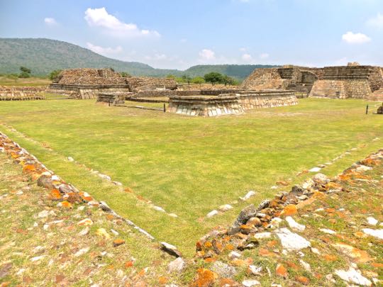 The west end of Casas Tapadas, viewed from the perimeter wall. The grassy area is one of the sunken patio spaces, with the Recinto in the middle. To its left is the #4 pyramid-temple and to the right is Casa de los Caracoles. This broad area would, no doubt, have been one of the main spaces for religious and political assemblies.

Voladores (flying dancers) are believed to have performed here as part of religious rituals aimed at encouraging rain and fertility. The dancers spun through the air, hanging by their feet from ropes attached to a tall pole. Modern Voladores still perform these dances throughout Mexico, but the result hoped for today involves pesos from tourists rather than rain from Tlaloc.

The single-level platform is bounded on three sides by a low talud y tablera wall, but is open to the west. Small vestibules on either side of the entrance might have stored ritual materials. The Recinto does not appear to have had walls higher than what we see today. There is no evidence of columns or interior walls to support a roof. To me, the structure suggests an open-air meeting place.
The participants would enter from the west side and sit facing each other along the walls of the other three sides. A council of priests, military leaders, and other elites may have assembled here to discuss weighty issues. It might also have served as a reception space for visiting dignitaries.

Casa de los Caracoles from its northwest corner. This structure is at the center of Casas Tapadas and is the largest of the four pyramid-temples. The name Casa de los Caracoles (House of the Snails) comes from ornaments on the structure in the form of spiral figures resembling snails or conches. Such figures represent the cycle of life and fertility and are associated with Quetzalcoatl, the god who introduced humanity to maiz (corn).
There is a small structure just left of the entrance stairs that may be part of an altar or perhaps a fragment of a wall that once encircled Casa de los Caracoles. Like the other pyramid-temples, this one has two stepped levels, with a partially destroyed temple on the second level. Leading into the west side of the structure is a stairway with two landings. The ruined temple has two rooms, one behind the other, connected by a central doorway.

Above, you can see that the pyramid-temple has had at least three incarnations. The oldest shows the talud y tablera style. It was covered by rubble which was then faced with smoothly cut stone. That version was later covered over with more rubble and smooth facing stones to create the final version. Rulers sometimes built a new temple over an old one to demonstrate their power, or to celebrate great victories or other significant events.
Rock carvings


Archeologists found it very useful in understanding the ruins as they were digging them out and partially reconstructing them. In total, there are almost 1400 rock carvings found around the Plazuelas site. They include spirals, circles, lightning bolts, and zoomorphs. Some of them indicate influences from other regions of Mexico.
Tree ring dating shows that a great drought occurred in northern and central Mexico from 897-922 AD. This would have drastically affected the harvests of the Epi-Classic societies and seriously weakened them. It also meant that the parched deserts could no longer support a hunter-gatherer way of life. Thus began one of the great Chichimeca invasions, as the fierce nomadic tribes migrated en masse from the northern deserts and into central Mexico.
This was the time period when Plazuelas met its fate, along with Xochicalco, Cacaxtla, La Quemada, and other Epi-Classic cities. All show signs of destruction and abandonment. In fact, the name La Quemada actually means The Burned Place. The Toltecs (900-1150 AD) were the next great empire. They may have been a melding of Chichimeca invaders and refugees from the Epi-Classic cities.
This concludes my posting on Plazuelas. I hope you found it interesting. If so, please leave any thoughts or questions in the Comments section below or email me directly. If you leave a question in the Comments section, please include your email address so that I can respond in a timely fashion.
Hasta luego, Jim
No comments:
Post a Comment
If your comment involves a question, please leave your email address so I can answer you. Thanks, Jim