Wednesday, January 22, 2020

Edzná Part 2 of 8: The Great Acropolis

The Great Acropolis, viewed from the top of the Southwest Temple. There are a number of impressive structures at Edzná, but the Great Acropolis contains the greatest concentration of them. To me, this is the most architecturally pleasing section of Edzná because of the sense of balance and proportion created by its ancient architects. In this posting, I will cover the western part of the Great Acropolis, including the Great Staircase, the Temazcal, and the Northwest and Southwest Temples.

In the photo above, the center of the plaza contains the Solar Platform, from which Maya priest-astronomers observed the movements of the sun. The North Temple is in the upper left, while the Pyramid of the Five Levels can be seen in the upper right. The steps of the Temple of the Moon are in the lower right.

In the Maya Cosmos, each of the four cardinal directions held closely intertwined religious and astronomical meanings. East, the direction of the rising sun, was the most important and so the Great Acropolis occupies the eastern side of Edzná's Main Plaza. Correspondingly, the east side of the Acropolis' platform contains its most important structure--the Pyramid of the Five Levels.


Overview

Satellite view of the Great Acropolis. In this photo, north is toward the top. The Southwest Temple, from which I took the previous photo, is located in the lower left corner. The Main Plaza of Edzná is to the west (left). All of the temples and pyramids that form the four sides of the Acropolis' face into its plaza, at the center of which is the Solar Platform.

The north side of the plaza is occupied by the North Temple, which faces the Temple of the Moon on the south side. The east side of the Acropolis is dominated by the Pyramid of the Five Levels.

On the west side of the Acropolis is the Great Staircase. This is the main access to the Acropolis' plaza and temples. The staircase connects the Northwest Temple on its north end and the Southwest Temple at its southern extremity. Extending out diagonally to the west from the Great Staircase are two sacbeob ("white roads"). These limestone roads connect the Acropolis with other ceremonial complexes within Edzná.


Sacbe leading from the south side of the Great Acropolis to the Ball Court. The two lines of stones seen above are the edges of the road. Sacbeob (the plural of sacbe) were constructed with stone blocks surfaced with limestone stucco. Often they were raised as much as 80cm (2.6ft) above ground level, particularly when crossing swampy areas. The white limestone stucco gave the roads their name. The goddess of the sacbeob was Ix Chel, who was sometimes known as  "she who walks the white road."

Some of these roads (like the one above) were used as processional ways connecting ceremonial areas within a city. Other sacbeob connected one city with another. The longest sacbe in the Yucatan Peninsula is 100km (62mi) long. It connects the ancient city of Cobá in the state of Quintana Roo to Yaxuna in the state of Yucatan. Inter-city sacbeob served both to aid economic activity and as an expression of elite power.


The Platform & Grand Staircase 

View of the Great Staircase from the Main Plaza. The top of the North Temple looms against the trees in the background. This west-facing staircase was designed to impart a sense of awe. Those who were permitted to ascend it faced the rising sun as they entered the sacred precinct. However, this may not have been the only entrance to the Great Acropolis. There is an un-excavated pile of rubble on the north side of the platform that archeologists suspect may conceal another stairway. 

The platform stands 8m (26ft) high and measures160m (525ft) on each of its four sides. It was a major engineering achievement on its own, requiring tens of thousands of man-hours. It should be remembered that everything in the ancient Maya world had to be built with tools of wood and stone and without the help of draft animals or the use of the wheel.


View of the Great Staircase and the Northwest Temple from the Southwest Temple. The Great Staircase is composed of four sets of steps. The first three sets have five steps each, separated by wide landings. The top set of steps is narrow and passes between structures that line the top of the staircase. The small, rectangular structure just north of the top of the stairs is the Temazcal.  

The Temazcal

The Temazcal played an important part in the Acropolis' ceremonies. A temezcal is a steam bath, or sweat lodge. It was used to purify the bodies of those who intended to make offerings at the temples or to officiate at ceremonies. Upon reaching the top of the stairs, but before entering the Acropolis' plaza, priests would enter the Temazcal through its colonnaded terrace and then turn left into the low entrance of the sweat room.

Temazcal decoration. This drawing of a relief carving shows the profile of a god with the flesh stripped away from the lower jaw. It is accompanied by a glyph indicating pictuns, or cycles of 360 days. Although the carving was found in the Temazcal, it appears to have come from a monument somewhere else in Edzná. Archeologists know this because the style of the glyph is from the Classic era but the Temazcal was not built until the Post-Classic. They suspect that the carving was placed here for purely esthetic reasons, unconnected with any calendric purposes. Re-using decorative elements was a common practice in the ancient world.


View of the top landing of the Great Staircase and the Southwest Temple. The southern half of the top landing contains another room with a colonnaded entrance whose purpose is not clear. It might have been a storage and dressing area for ceremonial attire. The Southwest Temple forms the south end of the Great Staircase. 


The Northwest and Southwest Temples

The Northwest Temple has five stepped-levels with a staircase on the east side. Although it has the same number of levels as the Pyramid of the Five Levels, the Northwest Temple is dwarfed by the larger structure. The columns of the Temazcal can be seen in the left center of the photo. It is unknown what god or gods may have been worshipped in the three rooms at the top. 

Certain architectural elements, including a Petén-style rounded corner, indicate that the Northwest Temple was originally built during the Early Classic period (300-600 AD). However, modifications were made during the Late Classic era (600-900 AD).


The Southwest Temple was also erected during the Early Classic period. The overall design of the temple shows the Petén architectural style prevalent in that era. There are four small rooms at the top that were probably built during the Late Classic period.

This completes Part 2 of my Edzná series. In my next posting, I will continue with my examination of the Great Acropolis, focusing on the Pyramid of the Five Levels, the North Temple and the Temple of the Moon. I hope you have enjoyed this posting and, if so, please leave any thoughts or questions in the Comments section below. 

If you leave a question in the Comments section, PLEASE leave your email address so that I can respond directly.

Hasta luego, Jim


Monday, January 13, 2020

Edzna Part 1 of 8: House of the Itza

The Pyramid of the Five Levels is the centerpiece at Edzná's Great Acropolis. Over nearly a thousand years, Maya architects used a succession of architectural styles as they enlarged and modified this structure. It follows the widely used format of a multi-level pyramid topped with a temple. However, the Pyramid of the Five Levels is unusual in having 22 rooms, many of which appear to have been elite residences.

During our visit to the state of Campeche, one of our top priorities was a visit to Edzná, one of the most important Maya city-states in the Yucatan Peninsula. The major monuments of the central area have been excavated and some of their ancient glory restored. In addition to the beauty of its pyramids, temples, and palaces, Edzná is significant for its unusually long history of occupation, its astronomical orientation, and its vast complex of waterworks.

The most probable meaning of the name Edzná is "House of the Itzaes". In this interpretation, "Edz" is equivalent to "Itzá" and "" is the Maya word for house. Itzá was the name of a ruling family of the Chontal-speaking Maya. During the 10th century AD, the Itzaes migrated into the Yucatan Peninsula from what is now the modern Gulf Coast state of Tabasco. Their migration was the result of the power vacuum created when the Classic-era Maya civilization collapsed. In addition to Edzná, they took control of other city-states in Yucatan. One of these was a city they re-named Chichen Itzá (Well of the Itzá). What the inhabitants called their city during the 1,500 years prior to the arrival of the Itzaes is still a mystery.


Overview

Edzná is located in the state of Campeche, not far from the capital which has the same name. The site is about 60km (37mi) southeast of the city of Campeche, in an area covered with deep jungle interspersed with patches of farmland. The location was very fortuitous in ancient times. Edzná is situated in a lowland that is about 1/2 way between the coast, with its rich maritime food sources, and the inland mountains with their resources of timber and wildlife. It also occupied a natural crossroads in the network of trade routes between the city-states of the Petén area to the south and east and those of the Puuc area to the north.


A strangler fig, encountered along the entrance trail. These strange trees are native to Yucatan and Central America. They surround and eventually strangle the host tree. Some of the Strangler fig's (Ficus cotinifolia) roots extend down from their branches rather than growing up from the ground. These trees form an important part of the jungle ecosystem by providing food and habitat for various animals. Uses by the pre-hispanic Maya included medicines for asthma and intestinal parasites and paper made from the bark. However, following Edzna's abandonment 500 years ago, stranglers have caused much destruction among the ancient structures. Their roots grow in the crevices between stone blocks and turn massive walls into rubble.

Based on analyses of ceramics found in the area, the earliest settlements at Edzna developed in the Middle Pre-Classic period (600-300 BC). At that time, the valley was heavily forested and swampy. In fact, the area surrounding Edzna forms the largest aguada (alluvial depression) in the whole Yucatan Peninsula. Aguadas naturally collect water and, in the process, develop layers of sediments. Since both are essential for crops, the area was ideal for early settlements. However, in order to create land for cultivation and living spaces, the settlers had to cut the forests and drain parts of the aguada.

The first structures were built with perishable materials. The walls were upright posts plastered with adobe (mud mixed with straw), while the roofs were thatched with palm fronds. Many of these structures were built upon low stone platforms to protect against flooding. Some platforms also served to emphasize the importance of the residents or the activities that took place there. The community grew steadily and as early as 150 BC, Edzna had as many as 20,000 residents. However, the great monuments we see today were still centuries in the future.


A Black Vulture spreads its wings while sitting on top of the Temple of the Moon. Bird specialists believe that wing spreading by Black Vultures (Coragyps atratus) causes parasites to concentrate in areas where they can be easily accessed by the bird. It may also be a way of warming up. The jungles of the Yucatan Peninsula were full of animals when Edzná was founded. Their feathers, skins, bones, and claws were used for clothing, personal decoration, and tools. Their meat supplemented a diet based on maiz (corn) and other cultivated and natural plants.

The community at Edzná grew steadily over the centuries. While the typical commoner continued to live in a traditional adobe-and-thatch , the dwellings of the wealthier members of the community increased in quality. In the better structures, walls of rubble, plastered with lime stucco, replaced adobe. Later, cut stone blocks replaced rubble. The more durable the structure, the more important the person who built it. However, two thousand years later, many in the Maya world still live in the traditional adobe-and-thatch ná.


Google satellite view of the key monuments of Edzná's ceremonial area. The photo above only captures the core of the city. The monumental area originally covered 6 square km (3.7 square mi), but much of that is still un-excavated and covered with forest. In total, the city covered as much as 25 square km (15.5 square mi). At the peak of its power and influence, Edzna was inhabited by about 25,000 people. While today the core area is closely hemmed in by jungle, in ancient times the area would have been clear and full of additional structures that extended out to a considerable distance.

In the photo above, north is toward the top. The large, open, rectangular area in the center is the Main Plaza. On the north end of the Main Plaza are the Platform of Knives and the Patio of the Ambassadors. Both of these contain elite residences. The long rectangular structure on the west is called Nohoch Ná (Large House), which was an administrative and civic center. Just west of its north end (see red pointer) is a small temple. This is called Structure 425 and it is unusual because of its circular design. The south end of the Main Plaza contains the South Pyramid and the Ball Court.

To the east is the Great Acropolis, a large platform which contains the Pyramid of the Five Levels, as well as several more pyramids, temples, altars, and a temescal (ceremonial sweat bath). Just south of the Great Acropolis is the Small Acropolis, a much older platform containing four temple/pyramids, each corresponding to one of the four cardinal directions and all facing the center of the Small Acropolis' plaza. To the south of the Ball Court and South Pyramid is a small plaza containing the Temple of the Masks and several other small temple/pyramids. The core area contains many more partially or completely un-excavated structures, but we had time to visit only a few of those. (Photo from Google satellite image)


Edzna's unusual features

Timeline showing Edzna's development. Along the left side of the chart is a column of dates during which the city was inhabited. 600 BC is at the bottom and 1500 AD is at the top. The next two columns show different eras of Maya development and artifacts from Edzna typical of each era. The next column to the right shows artifacts typical of other areas in Mesoamerica during those same periods. Finally, the far right column shows artifacts from other parts of the world matched with the timeline. (Chart from Edzna, A Pre-Columbian in Campeche by Antonio Benevides Castillo)

One of Edzna's most remarkable aspects is the breathtaking 2,100-year length of its occupation. It is true that, during its first and last centuries, the city was sparsely populated. Still, this is an unusually long lifespan for any city of the Maya world, or the rest of Mesoamerica for that matter. This span of time begins with the last stages of the Olmec civilization (the "Mother of Cultures"). It continues almost all the way to the end of the Aztec Empire. The only other Maya city with a comparable lifespan is Dzibilchaltún (500 BC-1542 AD). In the broader Mesoamerican area, Cantona (600 BC-1050 AD) had a very lengthy period of occupation but still falls well short of either Edzna or Dzibilchaltún.


The Solar Platform and its altar occupies the center of the Great Acropolis' plaza. In the background are the Northwest Temple (left) and North Temple (right). The Solar platform is a low, flat, two-level structure with an east-west orientation. Attached to the west side is a small, two-level altar. Archeologists believe the platform was used for solar observations because of its orientation.

The Maya became great astronomers and calendar makers in order to understand their world, and particularly its agricultural cycles. As it happens, Edzná is the only ancient Maya city located along the Latitude 19.5 degrees North. This line bisects the Yucatan Peninsula from east to west, passing directly through Edzná. The city's astronomers discovered that the sun reaches its zenith (directly overhead) on July 26, as it passes along this line. Thus, that date became the beginning of their year, from which all important events of the coming year were calculated. These included planting, harvesting, religious festivals, the dates for royal accessions and burials and much more.

All this meant that Edzná became the ancient equivalent of Greenwich, England, on which modern time is calculated. Archeologist Eric Thompson discovered that when Edzná's astronomer-priests made adjustments to their calendar in 671 AD, all the other Maya cities' calendars subsequently reflected the change. Given the vast importance that the Maya placed on the concepts of time and the calendar, this gave Edzná a unique place in its world.


Map of Edzná's water system. Just left from center is a small square. This represents the core area, seen previously in the satellite photo, which contains the pyramids, temples, and palaces. Surrounding the core area, like the spokes of a wheel, are an array of canals, moats, and reservoirs. The axis of the hydraulic plan is a 12km (7.5mi) long canal with a width of 50m (164ft) and a capacity of 900,000 cubic meters.The total system included 31 feeder canals, 84 reservoirs and an overall capacity of 1.5 million cubic meters. It was an extraordinary engineering achievement for its time.

There were several purposes for this huge system. These included draining excess water from cultivated land and living areas, storing water during the dry season, fish farming, serving as a transportation network, and functioning as part of the city's defensive system. Edzna's waterworks laid the groundwork for the city's development into an important regional power and contributed to its longevity. While other Maya city-states developed hydraulic systems, few were this extensive and almost none were begun as early as Edzna's. (Chart from Edzná, A Pre-Columbian in Campeche by Antonio Benevides Castillo)

Edzná's inhabitants during the Middle Pre-Classic era (600-300 BC) would have found it very difficult to get around during the rainy season, when the great aguada filled up with water. The flooding also inhibited their ability to grow sufficient food for an ever-increasing population. During this period, a small group of families gathered authority, probably by professing a special relationship with the ancestors and the gods. Supplementing this would have been their growing knowledge of celestial movements. Such knowledge would have enabled them to predict the proper dates for planting and harvesting. All this would have given these families the power to organize the community. The most important early result was the hydraulic system. These early social and political developments, and the resulting waterworks, pre-dated the construction of the great core monuments by centuries.


A Green iguana sunbathes on a rock wall in the Great Acropolis. Green iguanas (Iguana iguana) are found in the lush, moist areas of the eastern Yucatan Peninsula, such as the environment around Edzná. While there are no human residents at the ancient city, there are plenty of these guys.

In my subsequent postings about Edzná, I will walk you around among the various monuments of the core area. Along with my photos, I will outline the history of the city and show the various architectural styles that were popular over the centuries of its occupation.

This completes Part 1 of my Edzná series. I hope you have enjoyed it and, if so, you will leave any thoughts or questions in the Comments section below or email me directly. If you leave a question in the Comments section, please leave your email address so that I can respond.

Hasta luego, Jim


Sunday, December 29, 2019

Campeche's Museum of Maya Architecture

The bell over Campeche's sea gate. The sea gate, called La Puerta del Mar, allowed entrance from the long pier where sailing ships once tied up. The bell not only announced the arrival of commercial ships but also served to warn of the approach of pirates or hostile naval forces.

The city of Campeche is the capital of the state of Campeche. It has a number of very fine museums. One of the finest is the Museum of Maya Architecture. It is located in Baluarte Nuestra Señora de la Soledad, one of eight bastions built along the colonial walls to protect the city from pirate raids.

In this posting, I'll first show you a little of the Baluarte. Then we'll look at the museum which is housed within it. The museum focuses on the four pre-hispanic architectural styles found in the state of Campeche. I have illustrated this part with photos I took at various sites during our visit. Next, I'll show some of the museum's stone carvings, statues, and stelae that adorned temples, pyramids, and palaces found around the state of Campeche. I'll end the posting with some of the beautiful grave goods found in Campeche's royal tombs.


Baluarte La Soledad

Detail of a model showing Baluarte La Soledad and the pier. The Baluarte is the triangular structure extending from the wall, next to the pier. In colonial times, the waves of the Gulf of Mexico used to crash against the shoreline just below the walls. Today the shoreline is about 200m (656ft) from La Puerta del Mar and the Baluarte.

There is a long structure shaped like a "P" just behind the Baluarte. It is the old Customs Office, known as El Palacio, which now holds the Cultural Center. El Palacio forms the north side of the Plaza Principal (Main Plaza of Campeche). To the east is the Catedral de Nuestra Señora de la Purisma Concepción. Directly across from El Palacio is a building that was the colonial palace of one of Campeche's leading citizens, but now contains a restaurant and various stores.


View from the Baluarte along the walls toward La Puerta de Mar. Carole strolls along the narrow walkway atop the wall. The seashore is to the right. When Campeche was threatened from the sea, Spanish soldiers were protected as they moved along the walkway from one baluarte or guard post to another. Baluarte La Soledad was the largest of the eight bastions. Its name refers to the solitude of the Virgin Mary on Holy Saturday. She is considered to be the protectress of sailors and ships.

In the 17th century, Campeche was the most important port and commercial center of the Yucatan Peninsula. A particularly important export was palo tinte, (dyestick) which was used to make a dye highly valued in Europe. In addition, Campeche was the entry point for many European goods eagerly sought by the Spanish residents of Yucatan. All this commercial traffic quickly caught the eye of the pirates who infested the Gulf and the Caribbean at that time.


Guard post on the northwest corner of the Baluarte. The guard post is about the size of an old-fashioned telephone booth. It has three gun slits that allow the occupant to fire directly out or to either side along the walls. In addition to several of these guard posts, the roof of the Baluarte contained cannon mounted in embrasures facing the sea.

The Spanish Crown was surprisingly slow to react to the pirate threat. It took 150 years of pirate attacks for the king to authorize the construction of the great walls. The attack which finally got royal attention occurred in 1687. It was led by the famous Dutch pirate Lorencillo, who nearly destroyed the city after occupying it for a month. Ironically, by the time the walls, baluartes, and separate fortresses were completed in the 1720s, the Golden Age of Pirates was nearly over. These old bastions are today used as museums, including a botanical garden, and are swarmed by tourists rather than pirates.

In the next sections, I will focus on the Museum of Maya Architecture that is housed in the Baluate la Soledad. First, I will show the four main architectural styles developed by the ancient Maya in the area that is now the state of Campeche. Next, I'll show some of the statues and stelae that decorated the pyramids, temples, and palaces. The final section will cover some of the grave goods found in royal tombs, including a spectacular jade mask.


Styles of Maya architecture found in Campeche

The roof comb of Edzna's Pyramid of the Five Levels. Roof combs are decorative structures built on top of a pyramid or temple. They are typical features of the Northern Petén style. The Petén region covers Northern Guatemala and the southern Yucatan Peninsula, including parts of Campeche. Roof combs usually supported elaborate stucco designs, sometimes including the faces of gods. 

Pyramids of great height are also typical of this style. The height of the Pyramid of the Five Levels measures 31.5m (103.3ft), from the ground to the top of the roof comb. In addition, the corners of Petén-style structures tend to be sharp-angled, rather than rounded. The Northern Petén style was popular during the Early Classic period between 300-600 AD. In later centuries, Puuc-style columns were added to the bottom level of the pyramid.


The Rio Bec style is exemplified by towers like this one at Dzibilnocac. There is a similar tower on the other end of the long rectangular structure. The twin towers are part of an architectural complex which includes a central pyramid and rooms situated on a long platform between the towers. 

Both towers are built to appear as if they have temples on top. However, they are actually solid with no interior space. Staircases on the front and back of the towers are set at very steep angles, with extremely narrow steps leading up to the simulated temples. Like the temples, the stairs are only ornamental and actually climbing them would be dangerous. Notice how the corners of the tower and temple above are curved rather than straight angled.

The Rio Bec style also features carved stone Chaac masks, representing the Rain God. Such masks are also found in structures of the Chenes style. The Rio Bec style was in use during the Middle Classic era (600-800 AD) and is largely centered in the southern part of the Yucatan Peninsula


El Palacio at Hochob is one of the best examples of Chenes style. This style was popular from 600-800 AD, making it contemporary with Rio Bec style. In fact, the geographic area where Chenes is centered overlaps with the Rio Bec area. This suggests considerable interaction between the city-states favoring the two styles. As previously seen with the Edzna pyramid, structures in areas dominated by one style often contain elements from others. 

In addition to Chaac masks, Chenes features ornate stone carvings with abstract themes. Some of these can be seen above on the facade of El Palacio. Chenes buildings tend to be low, one-story rectangular structures, with decorations around the main entrance simulating the face of a monster. A person entering such a doorway does so as if being swallowed by a gaping mouth. The porch in front of the entrance of El Palacio is lined with large fangs.


This small temple at Xcalumkin has columns typical of the Puuc style. The temple is part of a complex called the Initial Series Group. The name is a reference to the Maya Long Count calendar, which begins on August 13, 3114 BC. All Long Count dates reference this "initial" date. The Initial Series Group was given its name by archeologists when they found Long Count dates carved into lintels supported by the columns. 

Puuc style was in vogue from 600-1000 AD and is concentrated in northeastern Campeche and southern Yucatan state. Xcalumkin was the main focus of development of the Puuc style during the 8th century. Signature elements of the style included entryways with porticos composed of plain columns such as those seen above. Other features of the Puuc style include rounded corners, rows of drum-like stone cylinders, and friezes decorated with reeds, latticework, serpents, and deity sculptures.


Gods and Sacred Symbols

Chaac masks were used extensively in both the Rio Bec and Chenes styles. The masks above are typical both in their appearance and the way in which they were used as architectural decorations. The long, upward-curving nose, square eyes, open mouth displaying fangs, and decorative earplugs are all signature elements of Chaac masks. The ones above were once used to decorate the rounded corners of a temple's facade. 

Chaac, the Rain God, was a Maya deity who was the equivalent of  Tlaloc, the God of Rain revered in central Mexico. Chaac was important because rain was vital to survival in this area. There are no above-ground rivers or lakes in the central and northern regions of the Yucatan Peninsula. In some places, water could be obtained from cenotes (limestone sinkholes), but Campeche has only a few of these. Pre-hispanic Maya in this area depended almost entirely upon seasonal rainfall. To capture it, they carved underground cisterns called chultunes. Into these, they channeled rainwater to create a supply for the dry season.


K'inich Ajaw, the Sun God, stares imperiously down upon the world. K'inich means "sun-eyed", and Ajaw translates as "lord". He is usually represented with large bulbous eyes, hence the name. This carving was recovered from Chunhuhub in northeast Campeche and dates from the Late Classic era (600-900 AD). 

K'inich Ajaw was associated with political power, war, and human sacrifice. This may explain his arrogant stance and intense glare. The feathered wings above the arms are representations of the sun's movement through the sky. Maya kings were thought to become assimilated with the Sun God after their deaths.


Unidentified bust with winged head dress. There was no sign with this sculpture, but the "sun eyes" and the head dress suggest that this is another representation of K'inich Ajaw. Notice the luxuriant handlebar mustache on the upper lip. 


Ruling Elites

An opulently-dressed ruler sits erect, as if listening to entreaties from a subject. His face emerges from the mouth of the monster, possibly a crocodile, which forms his head dress. A face emerging from a monster's mouth is a recurrent symbol in Maya art. The ruler's chest and stomach are covered by an apron adorned with large jade disks and he wears jade bracelets that cover most of his forearms. The figure displays considerable facial hair, including a handlebar mustache and a well-trimmed goatee. This is one of the most beautiful pieces of Maya sculpture that I have yet encountered.


Stela of a Maya figure named Lord Dog. Stelae are upright stones, usually flat on two sides, often containing low-relief carvings of human or animal figures and hieroglyphic symbols. Archeologists can glean important information from a stela's images and glyphs. These reveal details about local history, ruling families, and the dates of events. Stelae are usually found at the base of staircases leading up to temples and pyramids.

The Lord Dog stela was discovered in the ruins of Itzimté, a Maya city in Campeche of the Late Classic period (600-900 AD). A date on the glyph indicates that it commemorates the ending of a tuun or 360-day cycle. This is confirmed by the image of a figure placing incense in a burner. The recurrent cycles of the Maya calendar were immensely important in their ancient society. They were occasions of great ceremony in which a ruler would have played a key role. 


Explanation of the Lord Dog stela. The figure shown is that of someone very high in status. Just in front of his face is the "mat" symbol associated with royalty. His headgear includes the figure of a dog and he wears a nose ornament, large ear spools, and jade bracelets. His right hand is hooked in his belt while he uses his left to drop incense (probably copal) into a burner called a censer. 

The glyphs across the top and along the right side are even more revealing. Moving from left to right on top, the first two show a Long Count date of January 10, 910 AD. No monument with a later date has been found at Itzimté, which was abandoned in the early 900s. 

The third glyph on top translates as Dog, while the one just below it is Ajaw, or Lord. In Maya daily life, dogs served both as pets and as sources of food. In addition, they had symbolic importance. The Maya believed that fire was first brought to humans by a dog and that dogs accompanied the dead into Xibalba (the underworld) to show the way. Dogs were often sacrificed and placed in tombs, apparently for this purpose.


Stela of a ruler carrying a spear. One of important functions of a ruler was to lead his warriors into battle, sometimes personally engaging in combat. Prior to the decoding of Maya hieroglyphics in the 1970s, it was widely believed that warfare was rare in the Maya world. Many believed that the ancient Maya were peaceful stargazers. 

However, once archeologists could finally read the history written on stelae and other monuments, they were shocked to find that the Maya were as blood-thirsty as any other people. In fact, their incessant warfare may have played a role in the decline of the Classic era Maya civilization.


Explanation of the stela with the spear-carrying ruler. The Maya loved to dress up for special occasions and war was one of those. The figure above wears an elaborate head dress which includes masses of feathers and a skull. In addition to the head dress, a feathered cape is draped across his back. The jumble of jewelry around his neck and wrists probably includes jade and shells. His right hand holds a spear while he clutches a small round shield in his left. An elaborate loin-cloth hangs between his legs and his feet are shod with high-backed leather sandals.

This sculpture is typical of those erected to commemorate victories in battle. One of the most important acts of any warrior was to capture enemy warriors, particularly a ruler or noble, and to bring them back alive to the victor's capital. The humiliated prisoners would be displayed, stripped of their finery and bound with ropes. Their usual fate was sacrifice by beheading, sometimes after torture. 

Beyond the simple glory of winning, wars were fought between city-states for control over the smaller cities and settlements that provided resources necessary to maintain the warring states. In addition, some conflicts resulted from internal power struggles between rival lineages. It is believed that most campaigns were waged during seasons when they would not interfere with planting or harvesting.


Other important figures

A ball player kneels, apparently after scoring a spectacular goal. Anyone who has witnessed a soccer match or an American football game will recognize this sort of "end-zone antics". The posture of the player seems to express triumph, as if he were saying, through gesture, "There! That's how it's done!" 

The ball player wears a protective wood and leather shield around his waist. His hair is bound with a leather strap and he is shod with sandals that extend up to protect the back of his calves. Further protection is afforded by the leather gantlet covering his left forearm. A jade bracelet adorns his right wrist.

No doubt the ball game was enjoyed by everyone involved, but it represented far more than a simple athletic contest. It was sometimes used to celebrate war victories, but also to peacefully settle political disputes between city-states, or between rival groups within a city. In addition, the game always carried deep symbolic meanings related to the Maya creation myth and the celestial movement of heavenly bodies.


Statue of rather imposing Maya matron, dressed to impress. Her full-length dress is cut so that it exposes her shoulders and upper chest. She has a stylish hairdo and her ears have been pierced to accommodate large ears pools. A necklace made from large balls of jade extends in a double strand down to the top of her dress. Jade bracelets cover most of her forearms. In her hands, she hold some sort of cloth. She appears to be middle-aged and is certainly of the noble class. 

In addition to their roles in the home and family, Maya noblewomen played important ceremonial roles, as well as in the political marriages which cemented relations between city-states. Beginning in the 7th and 8th centuries AD, women occasionally became rulers. Maya city-states where this occurred included Tikal, one of the greatest of them all. Generally, female rulership occurred when there was no male heir to the throne, or through regency when the male heir was too young to rule.


Stela showing a dwarf dancing at the feet of a king. In addition to the dwarf, this round stela displays a seated ruler, surrounded by his advisors, generals and priests, as wells as musicians, singers, and servants. The scene is typical of a Maya royal court. The dwarf may be there simply for court entertainment or he may be a war prisoner. The stela was found in the ruins of the city of Bakná, in Campeche, and dates to the Late Classic.

Dwarfs are extensively represented in Maya art. They were believed to possess magical powers and were often given honored places in the households and courts of rulers, priests and high nobles. They are often portrayed in statues and in ceremonies of a mythological nature. They are often associated with emblems of political power. Oddly, very few dwarf remains have ever been found in pre-hispanic archeological sites.


Elite burials and their grave goods

The Jade Mask of Calakmul is considered the most beautiful of all Maya masks. This was the funerary mask of Yuknoom Yich'aak K'ahk (Jaguar Claw), a ruler of Calakmul who lived from 649 to approximately 700 AD. Calakmul was the great rival of Tikal, in a confrontation that lasted for centuries. Yuknoom Yich'aak K'ahk was katoomte (overlord) of the Kaan (Snake) Dynasty and Calakmul's last great warrior king. Calakmul is located deep in the vast Petén jungles southern Campeche. The mask was discovered in the king's tomb in 1984.

This jade mask incorporates many important Maya symbols. The circular ear spools are in the shape of the four-petal flower, which represents the four cardinal directions and, as such, the structure of the world. The ability of flowers to inhale and exhale moisture symbolizes the sacred "breath of life". Under the mask's chin are the extended wings of a butterfly, which represents the soul of the deceased monarch. Butterflies also represent Venus, the Morning and Evening Star, a symbol of rebirth and regeneration and the cycle of life. 

The arch at the top of the head dress represents the Witz, or Sacred Mountain. Within the Witz is a Sacred Cave where human life was born from three grains of corn. The monarch's tomb itself represents the cave, while the pyramid within which it is located represents the Witz. Just under the arch at the top of the mask are two sprouts of maiz (corn). Corn was not only the origin of human life but the basis of its subsistence. After death, the king becomes a grain of corn which sprouts into the Maiz God. The corn then represents the continuity of human existence.


A burial costume fit for a king. The jewelry shown in the model above was recovered from the remains of an individual of the highest status. Royal tombs have often been found inside pyramids, either within the staircases leading up to temples or under the floor of the temples themselves. 

One of the most famous Maya burials was that of K'inich Janaab' Pakal, also known as the Pakal the Great of Palenque. He was buried at ground level, after which a large pyramid was built over the spot. The royal tomb was only discovered when an archeologist lifted up a stone panel in the floor of the temple at the pyramid's top and found a staircase leading downward. 

Excavation took a long time, but when the rubble was finally cleared from the passage, the archeological team found a huge sarcophagus at the bottom. Its great stone lid was covered with exquisite carvings. The remains of Pakal lay inside. A jade mask covered his face, while the rest of his body was adorned with jade ear spools, necklaces, bracelets and rings similar to those shown in the display above.


Containers used for grave offerings. These containers were found in the same tomb as the jewelry in the previous photograph. Analysis of the containers revealed traces of burned soil, seeds, shells, stingray spines, and hematite (ferric oxide). All of these are typical of the materials used in Maya funeral rites. In royal burials, hematite would be combined with cinnabar to form a paste that was smeared over the body as a kind of shroud. Stingray spines were used in auto-sacrifice, a practice where an individual punctures his/her own flesh, sometimes to produce blood for offerings or a trance produced by the pain.

This completes my posting on Campeche's Museum of Maya Architecture. I hope you have enjoyed it and that, if so, you will leave any thoughts or questions in the Comments section below. If you leave a question, please include your email address so that I can respond.

Hasta luego, Jim

Friday, November 15, 2019

Campeche's Hacienda Uayamón

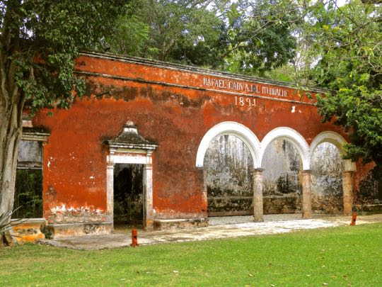
Arched portales of the hacienda's henequen mill, seen through jungle foliage. Hacienda Uayamón is one of Campeche's oldest and most important plantations. As anyone who follows my blog well knows, I am very interested in Mexico's old haciendas. So, I made it a point to stop here while we were looking for ancient Maya ruins near Campeche. In 1997, the ruins of Hacienda Uayamón were transformed into a boutique hotel. It has a nice restaurant, so we decided to have lunch there. There were no other restaurant customers or hotel guests, so we the entire place to ourselves. After our meal, I was able to wander around and take photographs to my heart's content without any pesky tourists walking through my shots.


Overview:

Hacienda Uayamón is located not far outside of the city of Campeche. The drive takes you 21km (13mi) southeast of the city through an area that is a mixture of lush farmland and deep jungle. During our visit to the state of Campeche, all the roads we traveled in the state were well-paved and maintained except those in the most remote areas. Unlike some other areas of Mexico we have visited, directional signs in Campeche are generally plentiful and accurate.

The Maya word Uayamón means "where the spirit descends" or "place where sorcerers go down." Jungles have always seemed mysterious to me, so I'll go with the definition about the sorcerers. An access road leads from the #60 highway through the forest to the hacienda. The map above is a screenshot from this Google map, which you can use for a more detailed look at the area.


View of the casa grande from the beautifully landscaped parking area. In the photo above, the casa grande appears to be painted a bright yellow. This is an illusion, however, created to by the bright mid-day sunshine. In subsequent photos, you will see that it is actually more of a rust-orange. We had no reservations and no one knew we were coming, so I was uncertain of the welcome we might receive. I should have known better than to worry. In Mexico, the expression "mi casa is  su casa" (my home is your home) is taken seriously. We were greeted graciously and given free run of the place.


View of the casa grande from the right. It sits at the end of a long grassy courtyard, with an old mill and an administrative building bordering either side. Both were in ruins. Above, a staircase leads up between two guest rooms to a dining area on a terrace-arcade with arched portales. The flat roofs of the two guest rooms are miradors (viewpoints) from which the whole front courtyard can be viewed.

Hacienda Uayamón was founded in the mid-1500s, not long after the conquest of the Yucatan Peninsula. During the 1600s, Spain's settlements along the Gulf and Caribbean Coasts were plagued by pirate attacks. The old colonial city of Campeche is still surrounded by walls and fortifications built to resist these depredations. Hacienda Uayamón did not escape these attacks unscathed.


Along the right side of the front courtyard are the ruins of the old mill. People unacquainted with old haciendas often assume the term refers to a grand old home. However, the word hacienda comes from the Spanish verb hacer, which means to make or do something. Therefore the term refers to a whole economic operation, usually a ranch or farm, but sometimes a mine.

A hacienda's economic focus often changed over the centuries, as new markets opened up. This was true of Hacienda Uayamón. During the latter part of the 16th century, large-scale cattle ranching was the focus. However, over the next 400 years, corn, sugarcane, henequen and .Palo Campeche, or "dye stick" were added to its mix of products.

Dye stick was one of the most lucrative. It comes from the logwood tree (Haematoxylum campechianum) and produces a brilliant red-orange dye. The Spanish first encountered Palo Campeche in 1540, when they conquered the Maya city of Kin Pech (Campeche). When the new dye was imported into Europe, it revolutionized the 16th century textile trade.


Along the left side of the courtyard stands an elegant building. Its position and structure suggest that it may have contained the hacienda administrator's offices and possibly his residence. Hacendados (hacienda owners) often did not reside permanently on their properties, which were usually quite rustic in the early centuries. Usually they lived in plush mansions in the nearest large town or city. An administrator was employed to live on-site and run the day-to-day operations.

The building seen above was constructed in the late 19th century, when Hacienda Uayamón was at the height of its wealth and power. Only a couple of decades later, the hacienda system in Mexico was overthrown by the Revolution. The brutal economic and social exploitation on which the system depended was destroyed and most of these old estates fell into ruins. Some of them, like this one, have gained a new lease on life from enterprising new owners who restore the old structures and refashion them into hotel/resorts.


La Casa Grande

The casa grande, seen from the roof-top mirador of one of the guest rooms in front. While many of its architectural details seem accurate, it is unclear to me how much of the structure above is original and how much is the product of the 1997 restoration by Mexican architect Luis Bosoms Creixell. In any case, haciendas often underwent changes, restorations, and enhancements over the centuries. The early structures were simple adobe, later upgraded to rough-cut stone, and then elegant brick.

casa grande was more than just the hacendado's residence. It was the nerve center of the operation and often included offices, meeting rooms, and a tienda de raya (company store). Sometimes, there was even a jail for workers who were insubordinate or who were recaptured after running away from debts owed to the hacendado. The owner and his family would have elegant apartments in the casa grande, for use during their periodic visits to the property.


The mirador, viewed from the terrace of the casa grande. In the background you can see the ruins of the old mill. The small, horse-shoe shaped structure on the front wall of the mirador is a campanario, where a bell once hung. Few workers had clocks or watches, so bells were used to alert them at the beginning and end of their workday. The bells could also warn of dangers such as fire or the approach of potentially hostile strangers.

From the late 16th century through the beginning of the 18th, the city of Campeche and its hinterlands were repeatedly raided by pirates. One of the greatest of these buccaneers was Laurens de Graff, known to the Spanish as Lorencillo. He was a Dutch privateer, working for the French in their war against the Spanish.

Privateers were essentially businessmen who contracted with governments to attack an enemy power's shipping in return for a share of the captured loot. Pirates, on the other hand, had no government association and shared their profits with no one but their fellow crew members. As his career progressed, de Graff decided to freelance as a straightforward pirate. In 1685, he seized the city of Campeche and held it for two months. During this time he sacked Hacienda Uayamón. Although he secured provisions for his forces, he found little in the way of treasure.


The terrace restaurant overlooks the front courtyard. Carole and I were the only lunch customers at the time. The white columns and rough vigas (ceiling beams) indicate that this is probably part of the original pre-restoration hacienda. The food was as elegant as the setting. After our lunch, I left Carole to enjoy the terrace view and went inside to photograph the interior.


This large dining room faces the rear patio. The structure of this room suggests that it may once have been a rear terrace. Its transformation into a large dining room was probably part of the 1997 restoration. Hacendados usually had large families, so big dining rooms are common features of casas grandes. Others dining with the family might include key employees, such as the hacienda's administrator, a priest assigned to the chapel, or a teacher employed to educate the hacendado's children. In addition there were occasional guests.

Haciendas also functioned as way-stations along roads leading to the interior. Travelers might stop for the night, enlivening dinner conversations with news  of the outside world. In the mid-19th century, early archeologists John Stephens and Frederick Catherwood were welcomed at haciendas all over the Yucatan Peninsula during their expeditions to find ancient Maya ruins.


A library with a checkerboard tile floor is just off the front terrace. Notice the small writing desk built into the middle of the bookshelves. Usually, the only literate people on a hacienda were the hacendado, his family, key employees, and the occasional visitor. The Maya field workers had a deep understanding of the natural world around them, but few were literate and most had little sense of the outside world.

Most hacendados were just fine with this situation, viewing an illiterate workforce as easier to control. Fernando Carvajal Estrada was one of the more enlightened of Uayamón's hacendados. In the late-19th and early 20th centuries, he sponsored a school for his workers and their families and even provided them with on-site medical services.


A smaller, more intimate dining room might be used for family-only meals. In the early centuries, hacienda furniture was made on-site from local materials by resident carpenters. The result would have been far more rustic than the elegant set seen above. As haciendas became more established and connected to the outside world, stylish furniture was often imported from abroad. 

When railroads were introduced in the last half of the 19th century, luxury goods became much cheaper and more easily obtained. In fact, the benefits of railroad transportation moved in both directions. Fernando Carvajal Estrada was one of the key promoters of the Campechano Railroad, which revolutionized the economics of haciendas like Uayamón. Suddenly, getting products to market took hours, rather than days or even weeks. As a result, hacienda profits skyrocketed, allowing the importation of even more luxury goods.


A circular seating area is located in the rear patio of the casa grande. This structure puzzled me at first. Then I remembered a horse-powered grinding process that I have observed in Oaxaca. In that case, the horse was grinding up maguey piñas to make mescal liquor. I believe that the structure above is the remnant of a similar process for grinding the hacienda's maiz. The animal would have been harnessed to the post. As it trudged around the circle, it would have ground the maiz by propelling a large millstone inside the circular space that is now filled with water. 


Seashells are thickly embedded in the ring surrounding the pond. At first, I assumed that the seashells were some sort of decorative element added in modern times. Upon further research, I discovered that seashells have long been used as aggregate to help bind concrete. Since the Gulf Coast is less than 20 miles away, a plentiful supply would have been available to those who built the horse-powered mill. After the hacienda was restored as a hotel, the old mill became the seating area we see today.


Raised-bed gardens produce food for the guests. While produce can easily be purchased elsewhere and brought to Uayamón, vegetables and herbs freshly picked from its own gardens make the hotel's meals especially tasty. In earlier times, growing your own food was not just desirable, but essential.

Haciendas were often located in areas some distance from external supplies. What takes a mere 30 minutes drive on today's asphalt highways would have required a whole day by horse or wagon along jungle trails in the 19th century. Haciendas attempted to be as self-sufficient as possible. In addition to a vegetable garden, there was usually an orchard to produce fresh fruit for the owner's table. 

El Molino

Ruins of el molino (the mill) where henequen was processed in the 19th and early 20th centuries. However, in the 16th and 17th centuries, cattle ranching was the main economic focus at Hacienda Uayamón. This was largely due to the population crash caused by Spanish diseases, from which the native people had little resistance. Cattle ranching was much less labor-intensive than farming. 

During the 17th century, Don Francisco de Cisero built the hacienda's cattle operation into one of the largest in Campeche. In addition to being a rich hacendado, Don Francisco was Colonel of the White Militia and a politician. By the beginning of the 18th century, the labor supply had rebounded somewhat and Uayamón began to raise maiz (corn) on a large scale. 


Chimney of the henequen mill. It may also have served during the time when sugar was one of Uayamón's main cash crops. Tall chimneys like this are typical features of hacienda mills. Sugar was one of the earliest cash crops in Spain's New World possessions. Cultivation was initiated first in the Caribbean islands and then on the mainland after the Conquest of the Aztec Empire in 1521. Hernán Cortez himself owned a very large sugar hacienda near Cuernavaca in the early 16th century. 

However, the conquest of Yucatan took much longer than that of central Mexico. Consequently, Spanish settlement of the Peninsula's interior was much more gradual. Along with the indigenous population crash, this probably accounts for the delay in adopting sugar as a cash crop at Uayamón. In fact, it was not until the second half of the 18th century that sugar became important to the hacienda.


The base of the chimney contains a plaque with the owner's name and the date of construction. Rafael Carvajal Iturralde bought the hacienda in the mid-19th century and was the owner when the mill was built in 1895. He came from a wealthy and illustrious family. His father, José Segundo Carvajal, had been the Governor of Yucatan in 1831. Rafael followed his father's footsteps and served as Governor from 1850-1853. By 1877, Rafael had made Uayamón the second richest hacienda in Yucatan. Rafael's son, Fernando Carvajal Estrada, was the hacendado who promoted the railroad from Campeche, brought electricity to the hacienda, and provided a school and hospital for his workers.


Inside the mill, graceful arches support an internal wall. I never fail to be impressed by the artistry used in constructing old structures like this, even when they are to be used for purely utilitarian purposes. The production of sugar requires a large number of field hands for planting, cultivation, and harvesting. In addition, highly skilled factory workers and technicians are required to operate the mill's machinery. By the time Uayamón started into the sugar business, Mexico had won its independence. The technicians would have been educated Mexicans with a smattering of Europeans.

In colonial times, many sugar mill workers were African slaves. Interestingly, the colonial Spanish found that the Africans they imported to the New World were particularly good at sugar mill work and favored them over indigenous workers. In some cases, they even used their African slaves as foremen over non-slave indigenous work crews. The last of Mexico's slaves were freed in 1829 and, after that date, the mill workers at Uayamón would have been free men, whether of African descent or not.


View through an internal window and external door into the courtyard. The red building across the courtyard is the administrative building. Today, the interior of the mill is only a hollow shell of what was once an intensely busy area. Still, I found it very photogenic with its arched doors and windows and other interesting architectural touches. 

Henequen (Agave fourcroydes lemaire) was Uayamón's other major cash crop. The fibre from the leaves of this plant has been used since pre-hispanic times to make rope, sandals, hammocks, and various textiles. In 1831, an American named Cyrus McCormick invented a mechanical reaper to harvest wheat. The machine baled the wheat straw with wire in a process that was much quicker than could be done by hand. 

Trial and error proved that henequen twine was much superior to metal wire, since it was less likely to become entangled in the machine. Since the Yucatan Peninsula was the only source of henequen at the time, haciendas producing it became immensely wealthy. McCormick's company  (today's International Harvester Corporation) was the world's largest purchaser during the great henequen boom of 1860 to 1910. At the time, henequen was called oro verde ("green gold").


Rafael Carvajal Iturralde's name also appears over the arches of the administration building. The date 1891 displayed on the building indicates that, like the mill, it was constructed during the height of the henequen boom. In addition to external demand, other factors helped create the boom. In 1847, the Maya Caste War erupted. One of the causes was the sugar industry's displacement of maiz, which the Maya considered sacred. In the conflict, the sugar industry was nearly destroyed. Ironically, this freed up labor for the emerging henequen industry. Later in the 19th century, a Mexican named Manuel Cecilio Villamor y Armendáriz invented a mechanical henequen shredder, which further increased production. 

However, when the Mexican Revolution broke out in 1910, the hacendados' good times came to an end. Although Fernando Carvajal Estrada was an enlightened employer for his time, elsewhere the Maya workers had been brutally exploited by the hacendados producing henequen, who were known as henequeneros. During the bitter fighting that occurred around Campeche, Hacienda Uayamón was occupied and its henequen machinery destroyed. 

The turmoil in the Yucatan Peninsula led to the planting of henequen in other parts of the world, causing prices to fall. Then, during the years following the Revolution, the government broke up Mexico's great haciendas and redistributed their lands to the campesinos (farm workers). By the early 1920s, the great henequen haciendas were in serious decline and many, including Uayamón, fell into ruins. 

This completes my posting on Hacienda Uayamón. I hope you enjoyed it and, if so, you will leave any thoughts or questions in the Comments section below or email me directly.

If you leave a question in the Comments section, PLEASE leave your email address so that I can respond.

Hasta luego, Jim