The Acropolis of Kinichná, viewed from the southwest corner. An acropolis is a citadel built on an area of high ground.
Kinichná ("The House of the Sun God") is a massive, four-level, pyramidal structure, with five temples on its upper three levels. Within the interior of the Acropolis, a royal crypt was found that contained the remains of two people. Scattered around the base of the structure are the remains of several small residential palaces which were the homes of a branch of
Dzibanché's Kaan (Snake) Dynasty.
Kinichná is connected to the core of
Dzibanché by a broad, flat causeway, called a
sacbe, which is surfaced with limestone stucco. S
acbe means "white road", a name that refers to the color of the stucco surface. The one that runs between
Dizbanche and
Kinichná is 2km (1.2mi) long. The ancient Maya constructed many such roads to connect important precincts within a city, as well as to connect one city with another. After visiting
Dzbanché's ceremonial complex, we drove the short distance to
Kinichná to check it out. (Photo from
Shore Excursioneer website)
Overview:
Unusual tree near the entrance of Kinichná. The Acropolis and its associated structures are surrounded by thick jungle full of unusual trees and plants. However, all this grew up after the site was abandoned, approximately 1300 AD. Before then, for at least a thousand years, the elite areas were surrounded by the homes of those who serviced their needs and, beyond that, by lush fields growing
maiz and other crops.
The area around
Dzibanche has an abundant supply of surface water, which is not typical of the rest of the Yucatan Peninsula. Most of the rest of the Peninsula is a flat shelf made of porous limestone. Water, in those areas, does not remain on the surface to create rivers and lakes, but seeps down into underground caverns and river systems. In northern Yucatan,
cenotes (sinkholes) provide nearly the only reliable access points. In areas lacking
cenotes, the ancient Maya created channels to direct rainwater to bottle-shaped, underground storage pits called
chultunes.
However, surface water is abundant in the southeastern Peninsula. Around
Dzibanché, low lying areas collect rain water to form
aguadas (seasonal ponds). One of these is adjacent to
Kinichná. The
aguadas were sometimes natural, but often were engineered
. In addition, large swampy areas called
bajos not only provided water, but also created a build-up of fertile sediments. The combination of water and fertile soil allowed for an agricultural system capable of providing sustenance to a large population. As a result, during the Classic Era,
Dzibanché grew to cover 40 square kilomenters. Archeologists theorize that
Kinichná was founded as a way to exert control over the fertile
bajos to the north of
Dzibanche's center.
A royal figure is dressed by servants in preparation for a great ceremony. The servant on the left adjusts a jade bracelet while the one on the right mixes pigment to be applied as makeup. The ruler is dressed in an elaborate costume, including a large quetzal-feather head dress and the skin of a jaguar. His lower legs and ankles are adorned by more jade. While the photo above is from a reproduction of a mural from another city, the rulers at
Dzibanché probably looked very similar in appearance and dress. (Photo taken at the Museum of Maya Culture in Chetumal)
The Maya system of governance during the Classic Era bore some resemblance to the feudalism of Medieval Europe. The ruler of a single city was called
ajaw (lord).The top figure in a city like
Dzibanché was called
kaloomté (overloard). The title indicates that
ajaws from surrounding cities or towns owed him allegiance and probably tribute.
Many of
Dzibanché's subject cities were ruled by members of the
Kaan Dynasty, These
ajaws often achieved their positions through marriage alliances or conquest. The images of the seventeen captives carved into the stone steps of the
Temple of Captives were those of
ajaws captured during conquests by
Yuknoon Ch'een I, the
kaloomté of
Dzibanché in 495 AD
. Almost certainly, the captives depicted were sacrificed and then replaced by
Yuknoon Ch'een's relatives or trusted subordinates.
Maya rulers maintained and extended their domains using a warrior elite. It is probable that
Kinichná was protected by warriors like these. In the center of the scene above, the leaders of two groups of warriors each grip the shaft of the same spear. This may indicate a meeting of allies, or perhaps a ritual in preparation for conflict between the two groups. The elite status of these warriors can be seen in their elaborate and expensive costumes. These include jaguar skins, exotic bird feathers, and even a crocodile totem. (Photo taken at the Museum of Maya Culture in Chetumal)
Maya warriors wore cotton under-armor, covered by palm-fibre armor. Other items of dress included a rigid waistband from which a long embroidered sash hung down the front. A short skirt made of flexible strips and knee protectors completed their battle dress. The warriors carried shields, either small and round or large and rectangular, depending upon their weapons. They were armed with a 2m (6ft) spear, as well as hand weapons made of wood and edged with obsidian. During the middle of the Classic Era, the influence of
Teotihuacan was very strong. As a result, the Maya adopted the
atlatl, a spear-throwing device used by
Teotihuacano warriors. Not much is known about tactics, but the opposing armies appear to have fought in close order, with the
ajaw and top nobility clustered in the center of the battle line. In addition to the political and economic goals of the war, capturing the enemy for sacrificial purposes was considered important.
The societal
impact of Maya warfare appears to have reached far beyond the elite class and its warriors. The winning side often experienced an increase in population and wealth. Major building projects often occurred after victorious wars, enabled by captive labor. The losing city's population tended to decrease. Outlying districts were often abandoned, with the remaining population settling closer to the urban center. Building projects decreased or ceased for a time, as did inscriptions on stelae.
During the first half of the Classic Era, warfare was controlled and there appears to have been a code of behavior that inhibited wars of mass destruction and annihilation. However, by the end of the Classic Era, warfare seems to have become much more intense and widespread. All this violence was one of the causes of the collapse of the Classic Maya society between 900-1000 AD. However, it has recently been determined that
Dzibanché, unlike its contemporaries,
continued as a functioning Maya city state until about 1300 AD.
Level A: The base of the Acropolis
Large trees grow on the broad staircase leading from the plaza to Level B. I am not certain whether the trees were retained for aesthetic purposes or possibly to help maintain the stability of the structure. Level A is a huge, pyramidal foundation and is the tallest of the four levels of the Acropolis.
The stone walls on either side of the staircase are filled with large, abstract designs. Their meaning is unknown, at present. The designs may extend all the way around the base of the Acropolis, but much of the structure has yet to be excavated.
The un-excavated rear of the Acropolis. This is how the whole structure would have appeared when it was discovered in 1927 by an amateur British archeologist named Thomas Gann.
Level B's twin south-facing temples
Topographical schematic showing the approximate location of Level B. As you can see, the Acropolis completely dominates the landscape around it. As a man-made structure, it must have taken immense effort and thousands of man-hours to build. As an expression of
Kaan power, it was intended to impress both
Dzibanché's own population and the rest of the Maya world.
Level B contains two, identical, south-facing temples, one at either end of its broad terrace. These structures each have two levels, with a staircase on their south sides leading up to the temple on top. The rounded corners in the center of the photo show the influence of the
Petén-style of architecture, popular in the Early Classic period (200-600 AD). All three levels of the Acropolis are from that era, along with its five temples and the royal burials under the top temple. At some point in the distant past, the temple above was looted.
The interiors of the twin temples each have two vaulted galleries. The temples are entered from a single doorway at the top of the temples' stairways. This photo was taken at the entrance of the west temple, looking toward the rear. The galleries have an east-west orientation and were once covered by corbel ceilings.
While the gods and rituals associated with these temples remain a mystery, there may be a hint in their geographic orientations. Both face south, which is one the
five cardinal directions sacred to the Maya. In fact the entire Acropolis is aligned on a north-south, east-west basis. In the view of the ancient Maya, the cardinal directions (north, south, east, west, and center) were not simply set on a horizontal plane, but were three dimensional. North and south also represented up and down.
View of the back of the east-side twin temple. Both of the twin structures underwent at least three stages of construction involving enlargements of their bases, but no change to the temples themselves.
The orientation of the Acropolis and its temples is significant because the cardinal directions were considered sacred.
Itzamna, the Maya creator god, had four sons called the
Bakab. Each was assigned to hold up one of the four corners of the world, which corresponded to four of the cardinal directions. Itzamna was apparently in the center. The
Bakab named
Hosanek was given responsibility for the world's southern corner. The four
Bakab were also associated with
Chaak, the all-important god of rain. So, it is possible that prayers and rituals associated with
Hozanek, or
Chaak, or both, could have taken place here.
Drawing of a small figure found on Level B. It is probable that the little statue had some ritual purpose. The figure stands with its hands raised, wearing what looks like modern boxing gloves. The closed eyes, expressionless face, and raised hands give the appearance of prayer. However, that may only reflect my modern perceptions.
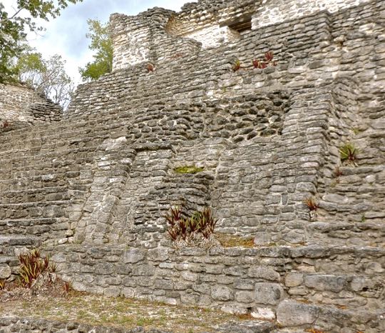
A broad staircase extends up from Level B's terrace to Level C. A tourist steps carefully as she makes her way down the ancient steps. Level C's east and west temples face each other on either side of the top of the stairs. Between and above them stands the the top-most temple, a dark doorway showing its single entrance. On either side of the staircase are four large, sloping panels which can also be seen in the first photo of this posting. Two panels are on each side, with one above the other. Each of these panels once contained a big stone mask.
Lower right panel, next to the staircase. In the middle of the panel are the remains of the mount where the mask was placed. The masks are believed to have represented
Kinich Ahau, God of the Sun. The discovery of a Sun God mask gave the Acropolis its name: House of the God of the Sun, or
Kinichná.
Similar masks of
Kinich Ahau are still in place on either side of a temple staircase in the ancient Maya city of
Kohunlich, not far to the south of
Dzibanché. We will visit
Kohunlich in a later posting.
Level C's twin temples face west and east.
The front of the west temple faces the rising sun. Level C's twin temples each have a single gallery, oriented on a north-south basis. Each also has a single entrance, which is gained by a four step stairway. Of the five temples on the Acropolis, these are the only ones that do not face south. Once again, the gods and rituals connected with Level C's temples are not known. However,
Kinich Ahau is associated with the east, where they believed the sun is born each day. A priest facing outward from the doorway of the temple above would be looking east, toward the rising sun.
The twin temple on the east side of Level C faces toward the west. The four steps leading up to the temple can be seen in this photo. If you stand in the doorway of this temple, looking out, you face in the direction of the setting sun. That is where the sun goes to die, before being reborn the next morning. Other interesting features of the twin temples include the sloping walls, or pediments, leading from the base of the temples down to the Level C terrace. Directly above each sloping wall is a vertical panel. This arrangement may reflect the
talud y tablera architectural style of
Teotihuacán. The influence of
Teotihuacán on the Maya was greatest during the Early Classic period when the Acropolis was built.
The topmost temple
The temple at the Acropolis' summit faces south. The staircase ascending from the Level C terrace to the temple has nine steps, a significant number to the ancient Maya.
Xibalba, the underworld of the dead, had nine levels. The number of stairs here may be a reference to the tomb found under the temple. In terms of the sacred directions, this is the most northern of the five temples and occupies the highest position on the Acropolis. In addition, the temple faces south and looks down to the plaza far below. Thus, from the Maya point of view, the temple has both horizontal and vertical orientations.
Itzamna is associated with both the sky and the center of the world. This temple is both the highest point on the Acropolis and the center of the whole structure. Given all that, my best guess is that
Itzamna may have been worshipped here.
The front gallery of the top temple. The temple has two galleries, or corridors, laid out east to west. Above, you can see the remains of the corbel arch that once formed the ceilings of both galleries. The entrance is on the right, above, and the passage continues through to the back gallery. Against the wall of this gallery you can see two low benches, or possibly altars. Underneath the temple floor, archeologists found a tomb containing the remains of two people.
Finely carved jade masks were among the grave goods buried in the tomb. The drawing above is an artist's rendering of the masks. I have been unable to find any photographs specifically identified as the masks from this tomb. The tomb's location, as well as the amount and quality of carved jade and other grave goods, both suggest the burial of at least one
kaloomté from
Dzibanché's early
Kaan Dynasty. It is possible that the second set of remains belongs to his wife or a close relative.
View toward the southeast from the front of the topmost temple. Given the height of the Acropolis, and the generally flat terrain around it, the vista is magnificent. I was glad that the authorities have not yet prohibited climbing its daunting set of staircases. Now, the real fun begins because the climb down from one of these places is always the most precarious.
This completes Part 4 of my
Dzibanché series and marks the end the series itself. I hope you have enjoyed visiting
Dzibanché and learning about its powerful
Kaan Dynasty. If you would like to contribute any thoughts or leave a question, please do so in the Comments section below, or email me directly.
If you leave a question in the Comments section, PLEASE leave your email address so that I can respond.
Hasta luego, Jim


No comments:
Post a Comment
If your comment involves a question, please leave your email address so I can answer you. Thanks, Jim