Saturday, February 2, 2013

Zihuatanejo Part 1: Steep hills, rocky points, and crescent beaches

View of Zihuatanejo looking northeast. After our stop at Patzcuaro to see the ancient Tarascan ruins at Ihuatzio (see previous posting), we continued on through Michoacan to the Pacific Coast near Ciudad Lazaro Cardenas and then south into the small, mountainous, State of Guerrero. A one hour drive along the coast road (Highway 200) brought us to the beach town of Zihuatanejo (Zee-hwa-tan-ay-ho). In the photo above, the most heavily populated part of Zihuatanejo  can be seen in the upper left. The curved beach stretching from the center to the lower right is Playa la Ropa. It is the largest of the four main beaches that lie around the perimeter of the small bay in front of Zihuatanejo. Each of the beaches is shaped like a half-moon with steep hills rising in back of it. There are rocky points at the tips of each crescent beach, separating it from the next one. The beaches vary in size from about 200 m to 1600 m (200 yds - 1 mi). The northern two, Playa Municipal and Playa Madera, are both about the same length and are the most heavily used. Playa Ropa is somewhat more quiet, and Playa Las Gatas, at the extreme south end of the bay, is the smallest and most isolated. In addition, there are a number of other small coves but the four I mention are the main beaches. For a Google map of the Zihuatanejo area, click here.


The Big Picture

Telephoto shot of Playa Municipal, the most northern of the four beaches. At the right is the beach where the fishermen pull up their launches so that they can sell their catch to the restaurants among the trees just behind the beach. In the center is the long pier where you can catch tour boats that will take you to various scenic spots around the bay. To the left is the channel leading to the marina. Behind all this is the relatively flat Centro area about 6 blocks deep. It contains shops, small hotels, and restaurants that cater to the tourist trade. Back behind the Centro area, the land rises sharply and is crowded with homes and apartments.


The point of land called Puerto Mio is on the northern arm of Zihuatanejo Bay. The point is dotted with sumptuous homes perched on rock cliffs around its shore. North of this point, about 8 km (5 mi) by land, is Xtapa, the Mexican Pacific Coast's answer to Cancun. Xtapa was conceived in the 1970s, and built from the ground up out of a coconut plantation. It is full of modern, all-inclusive hotels and is, like Cancun, a "tourist bubble", somewhat sealed off from the real Mexico that we were seeking. By contrast, Zihuatanejo is small-scale, colorful, quirky, filled with ordinary Mexican people who actually live there, has a history going back to pre-hispanic times, and is close to my definition of what a Mexican beach resort should be.


Playa las Gatas is sheltered by a cove on the point forming the southern tip of Zihuatanejo Bay. Playa las Gatas is the beach you can see in the center left of the photo. The point of land at the top of the photo is the northern tip of the land surrounding the bay and, along with the southern point, forms its entrance. Playa las Gatas reputedly has an offshore reef built by one of the ancient Tarascan kings. The beach is named for the whiskered sharks that once--but apparently no longer--gathered there. There are regular boats to the beach departing 8 AM - 5 PM from the pier at Playa Municipal shown earlier. Playa las Gatas is reputed to be the best snorkling location in the bay because of its clear water. Snorkling gear can be rented from the beachside restaurants. However, swimmers must beware of sea urchins which can deliver a painful sting. Carole and I never actually put our feet on the sand of this beach because we got lost in the maze of roads winding around the peninsula above it. We never found time to visit by boat, but perhaps next time.


Playa la Ropa

A quiet morning stroll on Playa la Ropa.  During our entire stay at Zihuatanejo, few of the beaches we saw got much more crowded than in the scene above, and this was in January, the top of the season! Perhaps, after all, Xtapa has been a boon to people like us. It has diverted intensive development--and the resulting tourist mobs--away from this idyllic, dreamy, beach community and concentrated it out of sight, a bit up the coast. Playa la Ropa ("Clothes Beach) got its name when a colonial-era merchant ship sank just off shore and its cargo of fine Bombay silks drifted in to the beach, no doubt delighting the local women. The gentle waves of this beach make it one of the best for swimming. Carole is not a fan of cold water, so she kept her distance at first. Testing it myself, I found it to be just a mite cooler than lukewarm and persuaded her to get her feet wet as we strolled the beach. She loved it!


Dotted throughout the coves of the bay, sailboats like this rocked gently at anchor. Every day, from dawn to dusk, there was a constant slow movement around the bay by boats of various sizes. Some were expensive sailboats like this, some were tour craft, and others were the launches of the local fishermen. It was mesmerizing to sit and watch this majestic movement, crowned by the slowly swirling flocks of brown pelicans overhead,


Small catamarans were available to rent along the various beaches, including Playa la Ropa. These simple craft are constructed from two narrow hulls with a nylon and metal platform connecting them. Someone once described a sailboat as "a hole in the water into which you pour money." Something like this would certainly create a smaller hole to fill than the sailboat in the previous photo. A catamaran this size can sail into remarkably shallow water and is light enough to easily pull up on the beach by hand.


And for those with really tight budgets... I watched in curiosity as this woman walked toward the water carrying her paddle and surf board. She waded out a few yards, mounted the  board and started stroking her way down the beach while I marveled at her sense of balance.


Hotel Irma

Hotel Irma sits on the side of a cliff overlooking Playa Madera. In writing this blog, I occasionally mention the hotels where we stay on our travels around Mexico. Usually, this is to give anyone following our footsteps a starting point in their search for accommodations. Generally, they are more or less comfortable places to sleep, in between the adventures we find while we're out-and-about. Hotel Irma is different, in a class by itself, and our experience there came close to making it the star of the whole show. The pool deck, seen above, is the level where you can see the horizontal blue line in the upper center. The water of the pool is level with the top of that line, allowing swimmers to gather in the water along the edge to enjoy the view.


The hotel is on the beach, yet set apart from it at the same time. The view here is from Playa Madera, looking south. Hotel Irma is the rust-colored, multi-level building on the side of the hill. The different levels provided wonderful, 180 degree vistas encompassing most of the bay. There is a steep, narrow, stone stairway leading down to the beach, but this is locked fairly early in the evening. Most of the time, we walked out the main entrance (in back of the top level you see above) and down the street to where there is an access alley to the beach coming out just to the right of the red umbrellas on the lower left of the photo.


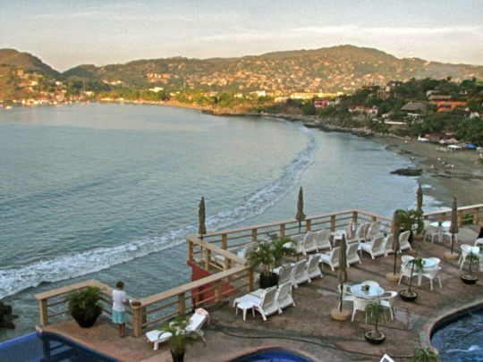
A view from the pool deck, looking north toward the Centro area. I took this shot on one of the levels overlooking the pool deck. You can see the pool and its blue wall at the lower left corner. We spent hours on this deck, watching the birds and boats, and the people frolicking on the beach. This shot was taken about 8 AM, as the sun was peeping over the hills behind me, leaving Playa Madera and the pool deck still in shadow. The view was so enthralling that we had to tear ourselves away to go check out the town.


Playa Madera, seen from the pool deck of the hotel. As you move north along the beach and approach the Centro, there are more and more small hotels, condos, and homes lining the beach. They are all "human scale" and don't project the imposing, even overpowering, sense of other resort beaches we have visited. At the busiest times of day, Playa Madera had perhaps twice this many people on it. The large dark object on the beach approximately in the center of the photo is a sea-sculpted rock. For those with limited budgets, or just wanting a change from more formal restaurants, the beach umbrellas at the center shaded very informal beach eateries.


This lush garden offered one of the many intimate spaces within Hotel Irma. Although the hotel offers 67 rooms, it provides a feeling of intimacy through its variety of levels, each decks of varying sizes, or quiet interior cubbyholes like this. It took me a bit of time to understand the layout, but the overall effect was to provide many options for privacy outside the confines of one's own room.


The pool's blue wall was a very popular gathering place, particularly in the late afternoon. Below the grassy area on the right, the cliff drops off sharply. While mornings are cool and breezy, and evenings after sunset are balmy, the afternoons at Zihuatanejo can get quite warm and sultry, even in January. A sultry afternoon is the perfect time to soak in the pool, while hanging your arms over the edge and quaffing an icy marguerita.


One of the interesting sights from the pool deck were the very fancy catamarans. There were two of these anchored offshore below the hotel, and they appeared to be identical. I never found out for sure, but I think these might be connected to the sunset cruises we read about. At about $60 USD per person, these were a little too rich for our blood, but some might find them fun.


Happy hour was a popular time on the pool deck. The hotel offered 2 for 1 margueritas for $40 pesos total (about $1.60 USD each). I haven't drunk alcohol for many years, but Carole persuaded me to drink one of the pair the waiter brought her. I can testify here that the bartenders certainly don't scrimp on the tequila! A hotel acquaintance scoffed that they weren't strong at all but, after drinking her pair, she at first couldn't find her keys, then lost her sunglasses. Through it all, she sat there with a glazed but happy grin. As you can see, the sunsets are spectacular, and they last for a long time.


The finale is sublime. The effect is stunning and on our high perchs on the pool deck, margueritas in hand, we had no complaints. The show just goes on and on as the colors deepen and finally settle into dark.


Even after dark, the show goes on. The lights around the bay would come on and sparkle across the water toward us. The telephoto shot above shows the malecon (waterfront area) along Playa Municipal. There is considerable nightlife in the Centro area, but we were cautioned to stay off the cement walkway that parallels the beach between our hotel and Centro after dark because of robberies that have occurred along that isolated path. In my next posting, we'll take a daytime stroll along the malecon. Every twist and turn reveals a sculpture, or people working or playing in interesting ways, or the abundant animal life.

This completes Part 1 of my Zihuatanejo series. I know many of my friends up north are currently enjoying frosty weather and snowdrifts (or rain squalls in Oregon). I hope they will be happy to see that somewhere out there is a world of sunshine, warmth, and long, slow walks along quiet beaches. I always encourage feedback, so if you would like to make a comment or correction, or yell at me for enjoying myself too much, please do so in the Comments section below or email me directly.

If you leave a question in the Comments section, PLEASE leave your email address so I can respond.

Hasta luego, Jim


Sunday, January 27, 2013

Ihuatzio, Ancient City of the Tarascan Empire

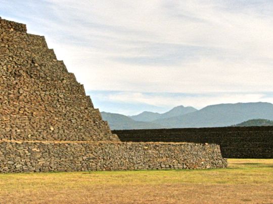
One of Ihuatzio's twin pryamids broods silently as rugged mountains rise to the east. The two pyramids at Ihuatzio are among the major features of the site, which is located near the city of Patzcuaro in the mountains of Michoacan. Carole and I recently visited the site on our way to the Pacific Coast beach town of Zihuatanejo. Since we were driving and the journey is a good eight hours, we decided to break it up with a stop just outside Patzcuaro. Several years ago, we visited Tzintzuntzan, the site of the ancient capital of what the Spanish called the Tarascan Empire. It is located along the shore of Lake Patzcuaro to the north of Patzcuaro. At that time, we had noted the existence of other ruins near the village of Ihuatzio, located about 1/2 way between Patzcuaro and Tzintzuntzan. However, we did not then have time to visit the site. On our recent Zihuatanejo trip, we were planning to reach Patzcuaro by mid-afternoon, so we built in a stop at Ihuatzio. Photographically, the timing was perfect. The golden glow of the winter afternoon sunshine reflected beautifully off the ancient stones, while the cool air made it very comfortable to clamber about the ruins.  For a Google map showing the locations of Patzcuaro, Tzintzuntzan, and Ihuatzio, click here.


Approaching the ancient city

The afternoon sun slanted across recently harvested fields of maiz (corn). The drive from our motel to the archaeological site was lovely. Michoacan is one of Mexico's most beautiful states, with ranges of heavily forested mountains separated by lush valleys and dotted with sparkling lakes. Ihuatzio is easy to find. While traveling along Highway 14, the "libre" (non-toll) road between Morelia and Uruapan, you turn north on Federal Highway 120, called the Carretera Patzcuaro-Quiroga. After about 4 kilometers (2.5 mi) you'll see a road leading off to the left toward Ihuatzio. The town is about 3 kilometers (1.8 mi) toward the lakeshore. Shortly after entering the town, you'll find a cobblestone road on the right leading up a hill and ending at the ruins. Drive with care, since you will likely encounter loose livestock on the road. For a map of the town and the route to the ruins, click here.

Ihuatzio means "place of the coyote" in Purépecha, the language of the ancient people and of their descendants today. Humans have inhabited the mountains and valleys of Michoacan for at least 10,000 years. During the millennia before the Spanish arrived, there were repeated waves of Chichimec migration from the far north into the area. "Chichimec" is a Mexica (Aztec) word that generally describes nomadic, non-urban people who might possess a variety of customs and languages. Among the early groups who settled in the area were the Nahua, Otomi, Matlatzincas, and Tecos. 


One of the local residents seemed to take a rather dim view of our arrival. This fellow looked us over dourly as we parked our car by the archaeological site entrance. Fortunately the large bull was on the other side of a stone wall. Unfortunately, he was pushing at the loose stones with his snout, apparently trying to create a gap through which he could pass. By the time we had completed our visit and were ready to depart, however, he had not made much progress. Who knows, he may still be working on it.

Ancient village sites have been found in the area dating back as far as the Pre-Classic era (1500 BC-200 BC) which makes those people contemporaries of the Olmecs. The best known culture from this era was the Chupicuaro, the people who inhabited islands in Lake Patzcuaro. Urban life developed during the Classic Era (200 BC-800 AD). Ball courts and other artifacts show that the area was influenced by the great trading empire of Teotihuacan (100 AD-650 AD) during the Classic period, and by the Toltec Empire (700 AD-1000 AD). Whether these influences came by peaceful trade or military activity is not clear.


Near the entrance of the site is a troje, similar to a traditional Purépecha house. Because of the thick forests in Michoacan's mountains, the indigenous people traditionally built their troje homes and other structures from wood. Unfortunately, ugly cinder block buildings have begun to replace these in many communities. The structure above is the small office of the archaeological site. The man sitting on the porch is the caretaker. The overall site covers 50 hectares (123 acres), but only part of it is open to visitors. The public site is a long rectangle oriented roughly east to west. It is part of a huge platform cleared and leveled in ancient times. This no doubt took immense effort given the lack of metal tools, draft animals, or wheeled transport at the time. Bordering the sides on the north and south are long walls, called Huatziri, which are unique in Mesoamerica.  For a satellite photo showing the layout of the ruins site, click here.


The great walls known as the Huatziris


The Huatziris served to restrict the ritual area, and could also act as defensive structures. The stepped walls are 80 m (240 ft) long and 5 m (15 ft) high. The top level is about 2 m (6 ft) wide. The Huatziris are built in the same manner as a typical stepped pyramid which, along with their length, makes them so unusual among Mesoamerican walls. It occurred to me that since the broad plaza they bound on the north and south was used for large public events, the steps would make ideal "bleacher seats" for an audience of thousands.

The Ihuatzio site's first period of occupation began about 900 AD when a group of Nahua-speaking people settled here. They found the food sources, particularly the fish in the lake, to be abundant and they developed a fairly dense population. About 1200 AD, the Purépecha-speaking Chichimecs arrived. While they were less culturally advanced than the Nahua-speakers already in residence, the Purépecha were decidedly more war-like and fairly soon extended their domination not only over the Lake Patzcuaro area but throughout Michoacan. 


The tops of the Huatziris are smooth and straight. Yet another function of the wall was to allow the cazonci (king) to move majestically along above the crowd from one end of the plaza to the other.

In the 16th Century, Spaniard Jerónimo de Alcalá described the founding of Ihuatzio in the "Relación de Michoacan," a document compiled by interviewing the surviving indigenous nobility. According to them, in the early period of the Purépecha conquest of Michoacan, a great king named Tariácuri decided to will his kingdom to his three nephews. He took them to the top of the hill called Thiapu and made three piles of dirt, set in a line. On each pile he placed a stone and an arrow. He called his nephew Hirapan over and pointed to the pile in the center and told him that this represented the town of the coyotes (Ihuatzio) and would belong to Hirapan. To Tangaxoán he gave Tzintzuntzan, and Patzcuaro went to Huiquingaje, his third nephew. 


Paralleling the southern Huatziri wall on the outside was a long walled road. Roads like this were part of Ihuatzio's ancient communications system and could also be used as defensive positions to impede an enemy attempting to assault the main Huatziri defenses. However, on the day we visited, the road was being used by a small, and very peaceable, herd of cattle that were meandering toward the pasture where they would spend the night.

King Tariácuri was one of the great Purépecha leaders during their conquest of Michoacan. While he was planning the capture of Ihuatzio, he sent his nephew Hiripan to the top of a hill north of the town to spy on the people living below. While Hiripan lay concealed, the god Curicaueri appeared to him and prophesied that he would become king. He then led his forces down upon the unsuspecting lake dwellers and captured a good many who were then given over to sacrifice. In honor of his victory, he decided to construct a temple dedicated to the worship Curicaueri and to store in Ihuatzio the treasures collected during the various military campaigns.


Plaza de Armas


The Plaza de Armas is one of the biggest Mesoamerican plazas I have ever seen. The platform on which it is based measures 300 m (900 ft) by 180 m (590 ft). The photo above, taken from the top of the south Huatziri, looks east down the length of the plaza. The corner of one of the two pyramids located on the west end of the plaza can be seen in the upper left.

Over time, Ihuatzio became the most powerful and important of the trio of cities that dominated the Tarascan realm. In good part, this was because Hiripan was the most aggressive and militarily accomplished of the three nephews. He took the lead in wars to expand and consolidate the territory controlled by the Purépecha. Over its three centuries of existence, the Empire extended throughout Michoacan and into parts of the modern states of Guerrero, Jalisco, Guanajauto, Querétaro and Colima. 


View of the plaza, and the south Huatziri, looking toward one of Michoacan's mountain ranges. The structure on the right is the northeast corner of the platform on which the two pyramids sit. The plaza could accommodate a vast crowd. Such an assemblage, dressed in full barbaric splendor with waving plumes of feathers, must have been spectacular.

Eventually, Hiripan died, and was buried at Ihuatzio. He left his realm to his son Ticatame who apparently did not possess the aggressive personality of his father, because it was during the son's reign that Tzintzuntzan became the key city of the Empire. Its ruler was Zizispandaquare, the son of Tangaxoan. He made his city the center of power, and took with him the god Curicaueri and the accumulated treasure that had been stored at Ihuatzio. It is not clear whether Ticatame objected to this arrangement.


Heaps of ancient building blocks dot the plaza here and there. These were structures of unknown purpose that have not been reconstructed. As stated before, most of the ruins of Ihuatzio are still just heaps of rubble and are not open to the public. Outside the Huatziri boundary, I saw another huge platform adjacent to the Plaza de Armas and perpendicular to it. This platform contains three yácatas which are structures again unique to the Purépecha Empire, and are similar to those found at Tzintzuntzan. Ihuatzio's yácatas are reported to contain tombs of important people from prehispanic times. In addition, there is a cylindrical astronomical observatory called the Mirador (lookout). Hopefully, at some future time, these will be opened to the public.

In spite of its loss of status, Ihuatzio and its rulers remained important players in the Empire. It was their job to rouse up the war-like spirit in the Purépecha soldiers prior to a battle. Ihuatzio's rulers also participated in the elite group who selected the next cazonci. Ihuatzio's ruler Paquingata, grandson of Ticatame, refused the position of cazonci when it was offered to him at one point.


The pyramids


Carole views the two stepped-pyramids that occupy the western end of the Plaza de Armas. The pyramids rest on a large platform and are separated from each other by a narrow corridor. At one time, there were temples on the top, but these have not survived because they were made of perishable materials. The cores of the pyramids are rock and earth, but the walls are of horizontally set slabs. The twin pyramids were dedicated to two Tarascan gods. One of these was Curicaueri, the patron of the Tarascan kings. He was a warrior god and the sun's messenger as well as god of the sky and the hunt.  The other temple was devoted to Curicaueri's wife Xaratanga, who was the goddess of childbirth and fertility and was variously depicted as a snake, a vulture, or a half-moon coyote. She was the daughter of Cuerauaperi, the earth goddess who was mother of all gods and controlled birth and death.

The Purépecha are notable for a variety of reasons. For one thing, their language is unlike any other indigenous group in Mexico. The only other related languages linguists have found are that of the Zuni people of the Pueblo Culture of the Southwest US, and the Quecha people of coastal Peru. This has led to an archaeological argument (they love to argue). Some hold that the Zuni language similarity indicates a Purépecha origin in the far north. Others point to the Quecha words in the language and suggest  a seaborne arrival from South America. The dispute remains unsettled, although the connection to South America has other interesting angles


A rear view of the twin pyramids. Curicaueri, according to some sources, was also the god of fire and had five brothers known as the Tiripemencha who ruled the five houses of the earth plane. These houses included the four sacred directions (north, south, east, and west) as well as the place where they intersected, the center of the universe. Curicaueri was represented by various animals, including the eagle flying above the earth, the coyote moving on the surface, and the snake traveling through the underworld. War captives were sacrificed to Curicaueri in solemn ceremonies after being intoxicated with fermented cornmeal prepared by priests.  They were then bound hand and foot, taken to the top of the temple to a special stone, and their hearts were removed with a sharp obsidian blade. The heads of those sacrificed were placed on a special rack similar to the tzompantli used by the Mexica (Aztecs).

Another of the important Tarascan distinctions has to do with their skill at metal-working. They not only crafted beautiful gold and silver jewelry, but they were the only group in Mesoamerica that used copper extensively to make weapons and tools. While the Mexica and other groups used copper for bells and ornaments, they seldom used it for axes and blades, preferring the traditional obsidian. Further, there was no copper ore in the Mexica areas, so the copper they did obtain through trade and tribute was previously mined and smelted and ready to work, if not obtained in already finished form. There is a strong possibility that the Tarascans obtained their knowledge of copper working through seaborne trade relations with the Quecha people of Peru. It is possible that the Purépecha could have originated in the far north, and picked up the Quecha words from traders from South America.


Detail of the twin pyramid on the north side of the platform. Including the two steps of the platform itself, there are a total of eleven steps leading to the top of the structure. Notice the rather roughly hewn horizontal blocks that make up the walls. On the left side is the corridor that separates the two pyramids. When this corridor was excavated, archaeologists found several skeletons and a one-ton Chac Mool, indicating a connection with the Toltecs. Chac Mools are always depicted as a man reclining on his back while leaning on his elbows with his knees bent. A bowl or tray always appears on the figure's stomach, ready to receive a fresh human heart.

The Tarascan Empire was also the first truly territorial state in Mesoamerica, another unusual aspect. All the others, including the Olmecs, Teotihuacan, the Toltecs, and even the Aztecs were either trading empires or based on tribute relationships with other states. Further, the use of metal weapons gave them a military edge over their great rival the Mexica, who launched several unsuccessful attempts to conquer the Purépecha. They were the only people to successfully repel such a determined effort by the Mexica. When the Spanish were besieging Tenochtitlán, the Mexica sent emissaries to the Tarascans asking for help. Because of their previous enmity, the Tarascans not only refused, but they sacrificed the emissaries, and looked forward to welcoming the conquerors of their great enemy.  It was a mistake they would come to regret.


Closeup of the pyramid's front (eastern) wall. Shown above are the facing blocks made from slabs of volcanic rock called xanamu. These blocks once covered the entire structure. There were once staircases ascending this wall, but little is left of them. Consequently, the pyramids cannot be easily climbed and such activity is discouraged by the caretakers for safety reasons.

The Purépecha maintained and extended their control up until the Spanish conquistador Nuño de Guzman arrived in 1530 AD. He destroyed their empire and scattered their people into the remote mountains. The Spanish misunderstood the Purépecha language and mistakenly called the people Tarascans, the name by which they are now commonly known. Nuño de Guzman burned their last king alive in an attempt to force him to reveal the source of the gold ornaments he and his nobles wore. It was a quick and drastic end to a great empire.


Ihuatzio, the "modern" town

View of the modern village of Ihuatzio, with Lake Patzcuaro in the background. The ancient ruins of Ihuatzio lie high up on the slopes of a mountain called Cerro Tariaqueri. As we descended, I stopped to capture this view of the village, the lake, and the city of Patzcuaro on the forested hills beyond. The town lies at an elevation of 2040 m (6692 ft) and has a population of over 3500 people, about 1/3 of them children. A lot of the people are poor, with 78 out of the 663 households lacking a floor, and 49 having one room only. Still, the overwhelming majority are connected to the public water supply, electricity, and even have a television. As with many rural populations, the education level is fairly low, with the average number years of school completed being seven. However, there are computers in 35 of the households.


A young horse out for a casual sidewalk stroll on a sunny afternoon. I always enjoy little oddities like this that are so commonly found in rural Mexico. Of course, to the local people, it wouldn't even be worth a second glance.


The Parroquia San Francisco de Asis was built in the 18th Century. No doubt the church replaced earlier versions dating back to the mid-16th Century.


Christmas decorations still adorned the interior in mid-January. This is not unusual, since the Christmas season in Mexico lasts at least until Dia de los Tres Reyes (Three Kings day) which falls on January 6. Traditionally, that is the day when gifts are exchanged, in keeping with the gifts brought by the biblical Three Kings to the new-born Jesus. Many of the decorations seen above are crafts for which Michoacan State is famous.


A wood-pillared walkway overlooks the Ihuatzio Plaza. Woodworking is another craft for which the people in this area are famous. In addition to the pillars above, much of the house behind the walkway is decorated with beautifully carved wood.


Detail of a plaza pillar. This kind of work is not reserved for public buildings or the homes of the wealthy. While traveling the back roads of Michoacan, I have seen this sort of carved pillar adorning some very humble dwellings.

This completes my posting on Ihuatzio. I hope you have enjoyed it and learned something new about Mexico. I always encourage feedback and if you have any comments, questions, or corrections, please leave them in the Comments section, or email me directly.

If you leave a question in the Comments section, PLEASE leave your email address so I can respond.

Hasta luego, Jim


Saturday, January 12, 2013

Our Annual Waterfall Hike and Corn Fiesta


Hikers approach one of the large falls within Barranca Yerba Buena. Every fall, for the past four years, a group of hikers from Lake Chapala's foreign community travels to a remote canyon south of the Lake for a hike up to a stunningly beautiful waterfall. Then they return for a fiesta hosted by a local Mexican farmer and his wife. My hiking buddy Larry and I "discovered" this canyon back in 2009 and have been leading groups of hikers to see its many waterfalls ever since. I put quotes around the word "discovered" because local Mexicans have been aware of the canyon for hundreds of years, and pre-hispanic indigenous people for thousands of years before that. However, to the best of our knowledge, we were the very first members of the foreign hiking community to find and explore it. In the process we also discovered Raul and his wife Germina. They are treasures every bit as wonderful as the waterfall canyon.


Raul, as we first encountered him in 2009. We were on our fourth excursion to the canyon when we met Raul. At the time, we were approaching from a new direction and were uncertain as to the location of the trailhead. We were crossing the corn field above when we ran into Raul, who was working with his newly sprouted plants. He seemed a bit surprised at the sudden appearance of our motley crew of foreign hikers. With my north-of-the-border mindset, I expected him to be hostile about our uninvited crossing of his land. Raul's reaction was quite the opposite. He speaks only Spanish but one of our hiking group was Mexican and she explained our quest. Immediately, Raul dropped his equipment on the ground and said "Let's go, I'll show you the way." With that, he led us on a four-hour hike into the mountains. Although we were all wearing expensive, lug-soled hiking boots, this tough Mexican farmer in his beat-up cowboy boots left some of us gasping as we attempted to keep up. At the end of our hike, Raul invited us to come back in the fall for a fiesta to celebrate his harvest. A couple of months later, we participated in our "1st Annual Corn Harvest Fiesta at Raul's Farm." In September of 2012, Raul and his wife Germina hosted the 4th Annual Fiesta. I neglected to bring my camera to this last one, so the photos shown later in this posting are of the 3rd Fiesta, held in late September 2011. Each of the fiestas started a hike to the waterfalls followed by a pot-luck feast either at Raul's lean-to shelter next to his field, or his home in the nearby small town of Citala.


A British hiker threads her way through towering sunflower stalks. The hiker above is walking through an area that was originally a rough bulldozer road leading down a steep slope into the mouth of the inner gorge. Since it was originally cut, the road has become deeply eroded and thickly covered with vegetation, including this large stand of wild sunflowers. Forcing your way through this jungle is no easy task, as you can see.


Karen, a Filipina-American, clowns her way across another canyon obstacle. Over the years, a number of hikers new to this trail have reached this spot, looked at the bridge, and refused to go further. However, Karen was pretty daring for a first-timer and crossed it without hesitation. Although the stream below her is fairly shallow, about 3 m (10 ft) downstream is a sizable waterfall. I certainly wouldn't want to be swept over it. Fortunately, the log is quite stable and whoever built the bridge also put up a steel cable. Hanging onto the cable while you edge across makes the passage reasonably safe.


Moving up the canyon requires repeated stream crossings and much boulder-hopping. Most of my fellow hikers carry sticks for just such occasions. Some of these are expensive, telescoping, high-tech models like the one above. I just use the handle I removed from an old mop and put a rubber tip on the end. It seems to work just as well and only cost me 3 pesos (25 cents USD) for the rubber tip. Each to his own. This kind of boulder hopping can be fun, but we generally restrain ourselves. A misstep could easily result in a sprain, a nasty gash, or even a broken ankle due to the slickness of the sharp-edged, water-splashed rocks.


As you move up Barranca Yerba Buena, the waterfalls get progressively larger. The one above is about 8 m (25 ft) high, and drops into a large pool. The people gathered at the top of the waterfall provide a sense of scale to the photo. The water is brown due to agricultural runoff from the plateau above the canyon. The steep canyon walls around the pool contain numerous seep springs. Rubber hoses run down from these to a cement collection tank. From there, the clean spring water runs through a metal pipe all the way down the length of the canyon to Citala, several kilometers away.


Someone placed this sun-bleached cow skull as a trail marker. Because there are few roads into the mountains surrounding Lake Chapala, cattle that wander through and die are left where they fall. They are soon picked clean by scavengers. It's not unusual for hikers to find piles of bones scattered here and there along a trail. When I am leading a party of hikers new to Mexico, I sometimes like to stop and nudge a large bone with the toe of my boot, casually remarking, "isn't this is about the spot where that guy Joe fell behind last year? I don't believe we ever saw him again. I wonder...?" This almost always draws a round of nervous laughter, as people glance at my dead-pan face to see if I'm kidding.


As we near the head of the canyon, the walls close in and the jungle fills the gorge. The trail at this stage is barely a faint track. However, the canyon is so narrow that it's impossible to get lost. Piles of loose scree require close attention to one's footing, however.


Gail crosses another log bridge along the way. The trick is to face downstream, lean into the cable while holding it with both hands, and edge along sideways one step at a time, never crossing one foot over the other.  It's no problem once you get the hang of it, but it can look pretty scary to someone unfamiliar with the technique. Gail moved down from Texas and is one of our regulars. She occasionally joins a small group who like to climb up and rappel down dry waterfalls using ropes and other equipment. I like that my hiking friends are such an adventurous bunch.  


Hikers descend a steep natural staircase. Natural steps like these can be found in many places along the trail. They are always welcome, because it makes the going much easier. However, it is still necessary to move with caution and probe the area ahead with your stick. Sometimes rocks that look cemented into place can be a bit tipsy.


Roots from an amate tree cling to the sheer cliff face. I am always impressed by the capacity of these trees to mould themselves to whatever rock surfaces are available as they send roots down looking for water. Amate ("ah-mah-tay") bark was used by the Aztecs to make paper.


Nearing the head of a box canyon, we first hear and then see the high falls. This cascade is actually the first of two high falls at the end of the canyon. While we have seen the falls beyond this one from their top, we have never been able to find a route leading to their base.


The falls drop almost vertically into a large pool in a box canyon. The stone walls of the canyon rise at a nearly 90 degree angle. The waterfall is probably about 30 m (100 ft) high, and the rock walls rise even higher than that. The mist in the canyon's base supports a variety of ferns, mosses and other damp-climate plants on the surrounding walls.


Up close, the roar of the water almost drowns any effort at conversation. Those of us who hike regularly in the mountains overlooking the North Shore of Lake Chapala are not used to finding year-round cascades such as these. The streams in the North Shore canyons usually flow only during July through September, after the summer rains have filled the mountain aquifers. The rest of the year those canyons are bone-dry. The South Shore stream shown above runs year-round because it flows out of a reservoir in a valley higher in the mountains. On a hot day, after sweating our way over boulders and other obstacles, it feels wonderful to stand in the cool drifting mist below a roaring cascade like this.


Karen strikes a pose at the box canyon pool. She and her sister and several of the wives of businessmen visiting Guadalajara decided to join the hike when they heard about it through one of our regulars. Karen drove them to the trailhead in a low-slung van. Her daring on the hike was matched by her daring on the rocky farm road leading to the trailhead. Unfortunately, her van was not built for such a road and she tore open the oil pan underneath. She made it back down to the paved highway, but the car had to be towed from there. As they say, sometimes discretion is the better part of valor.


A couple of hikers negotiate another tricky spot. There is another natural set of steps here, but climbers must stay as close to the wall on the left as possible. To the right, the canyon drops off steeply to the stream bed below.


The hardest part of the hike is negotiating the steep climb back up the bulldozer road. When you come out the mouth of the inner gorge, you are usually already a bit tired. Now you must trudge up a path leading to the plateau overlooking the outer canyon. There are no tricky parts to this, but it always seems like an endless upward trudge. The icing on the cake is that you usually reach this section in the afternoon when the high, hot sun leaves little shade. Fortunately, this steep section is not as long as it sometimes seems. Step by step on the way up, I always remind myself of the cold drinks that await us, once we reach the cars on top of the plateau.


Citala nestles close to the base of a mountain overlooking a broad valley full of small farms. The stream in the bottom of our canyon flows right through the middle of this small, rustic village. Citala lies in a heavily wooded area, and you could easily miss it from the highway if you didn't know it was there. When I took the photo above, I was standing at the edge of the plateau looking out over an unharvested section of Raul's field. I sometimes kid him that he has a "million dollar view" from his fields, but it's true. At the edge of his property, Raul built shelter with rock walls on three sides and open on the forth. The overhead beams made of large, rough-trimmed tree branches are roofed with red clay tiles. Surrounding the shelter is a low, dry-stone wall. The effect is very picturesque and it made a great spot for our Fiesta.


Hungry hikers relax by the stone wall surrounding Raul's rustic shelter. Raul and Germina supplied huge pots full of freshly-picked corn on the cob, some boiled and some roasted. Germina also made a delicious dish made of candied calabasa (squash). We, in turn, brought roasted chickens, salads, desserts, and many other goodies. As a special treat for Raul, the hikers chipped in for a bottle of  Centenario, his favorite tequila.  Germina was presented with a lovely bouquet of flowers.


Our host and hostess pose with a special t-shirt. Someone thought to bring a new, white t-shirt and a marking pen. We all lined up to sign our names and leave appreciative comments. Mexico has wonderful landscapes, great pyramids, and stunning colonial art and architecture. However, the very best part of this country are people like these simple, generous, fun-loving farmers who seem as delighted to have us as friends as we are with them.

This completes my posting on the Corn Harvest Fiesta. I hope you enjoyed it and, if so, will feel free to leave a comment in the Comments section below or to email me directly.

If you leave a question in the Comments section, PLEASE leave your email address so I can respond.

Hasta luego, Jim