Tuesday, March 18, 2025

Valladolid Adventures Part 5 of 22: Templo San Servacio


Valladolid's Templo San Servacio is one of  the city's most recognizable features. Photos and paintings of the church appear everywhere. There are other colonial-era churches in Valladolid that are as old as this one, and some of them have interesting histories. However, none are as grand, beautifully proportioned, or are as historically important as San Servacio. The Templo stands opposite the south-eastern corner of the Parque Principal Francisco Candón Rosado, the main plaza of Valladolid. San Servacio's twin towers are visible from almost anywhere near the plaza.

In this posting, I'll first show you some of the interesting exterior features, before venturing inside to check out the mix of Baroque and Neo-Classical elements of the interior. As we move through the photos, I'll tell you the extraordinary history of the Templo. It is a story that goes back to the earliest days of the conquest of Yucatan and includes important events in the early 18th and the mid-19th centuries.

Exterior 

Main entrance of the Templo. It is framed by double pilasters on either side and an arched doorway, all decorated with a series of small crosses. Aside from these decorations, the rest of the facade is decidedly austere. The exterior of the church resembles some of the early-colonial "fortress churches" in central Mexico. This impression is confirmed by the two tall towers, one on either side of the facade. These contain narrow vertical openings forming gun slits as a defensive measure during recurrent periods of Maya unrest. At those times, the church was used as an actual fortress. I will talk about this further along in this posting.

The original church which once stood on this spot was demolished in 1705 and replaced by the one you see today. The former structure was built using stone from the large Zaci pyramid that once occupied the space where the Parque Principal is today. It is very probable that many of the limestone blocks originally looted from the Maya pyramid were salvaged in 1705 and re-used to build the current structure. I base this on the fact that the Spanish practice was to re-use building materials when they could. Quarrying, shaping, and transporting new limestone blocks from elsewhere would have been excessively expensive. 


Floral decorations cover the pilasters and the arch over the door. These decorative elements are among the few Baroque features of the otherwise austere exterior. The original Templo San Servacio was built on this site in 1545, after Valladolid was moved here from the city's original location a few miles to the north. The earlier church faced west, while the one you see today faces north. Why the original church was replaced and the new one geographically reoriented is a fascinating story. It involved sex, violence, politifcal intrigue, and retribution, all played out at the and of the 17th and the beginning of the 18th century. 

Near the end of the 17th century, a man named Fernando Hipólito de Osorno was appointed as Mayor, Lieutenant Governor, and Captain General of Valladolid. This was largely due to his close relationship with Pedro de los Reyes Rios del la Madrid, the Bishop of Mérida. As the story goes, Mayor Osorno was "a bright eye". This is another way of saying he was avid in his pursuit of beautiful women, regardless of any other relationship they might already have. As it turned out, the lady in question was the girlfriend of Miguel de Ruiz Ayuso, another important man. Ayuso felt that his honor had been outraged and he vowed revenge.


The twin towers viewed from the right rear. There are two levels on top of each tower and spaces for four bells on each level, amounting to sixteen bells in total. Quite a cacophony, if they all rang at once! There was at least one occasion when this actually happened, which I will relate later in the story of the church. The side walls of the church are more than 10m (30+ft) high, furthering the fortress appearance. Along with that are the circular openings in the railing along the top of the wall, which would have provided protection for marksmen should the church be attacked.

The jealous Miguel de Ruiz Ayuso also had political connections. These included Martin de Urzúa y Arizamenid, the Captain General of the Province of Yucatan. Ayuso claimed that Mayor Osorno had committed irregularities and mismanagement while in office. Osorno's friend and lawyer Pedro Gabriel de Covarrubias was also charged. Osorno was removed as Mayor and he was subsequently arrested and imprisoned on these fabricated charges. However, he soon escaped from the jail and took refuge in Templo San Servacio, where he was later joined by Covarrubias.


Rear of the church and a view of the circular wall surrounding the dome. The circular wall may have been intended to function as a last bastion, sort of like a castle's "keep". All these fortress features provide a sense of power, but also indicate an underlying insecurity and fear of attack. Except for the finials on the corners of the towers and atop of the railings and the circular walls, there are almost no decorative features.

Ayuso got his friend the Captain General of Yucatan to appoint him as Mayor of Valladolid.  For good measure, Ayuso's henchman Fernando de Tovar y Urquiola was made Second (Deputy) Mayor. Since the Middle Ages, the Catholic Church had traditionally offered sanctuary to fugitives. Ayuso chose to ignored this and, along with the Second Mayor, he incited and led a group of eight men to break into the Templo. Osorno and Covarrubias were wounded and dragged out to the front of the church. There, Osorno was beaten to death. Covarrubias was then taken to the jail where he too was killed. Both men's bodies were hung from the jail's window. Ayuso had savagely restored his honor.


This door on the west side of the church was once the main entrance. Two pilasters support an arch over the wooden door. The pilasters and arch are decorated with a series of small crosses, but the walls surrounding them are covered with rough stone. This original entrance faced west because, ever since the 4th century AD, Catholic churches have been built with their main door facing west. This was so that worshipers who entered would be facing east, the direction that symbolizes renewal, warmth, and the light of Christ. West is the direction of the setting sun, darkness, gloom, and death. 

The murders, which were committed on July 12, 1703 are known as "the crime of the mayors". Osorno's benefactor, the Bishop of Mérida, was outraged not only by the crime, but by its commission within the Templo. Blood was actually splashed on the altar. He complained to the Viceroy in Mexico City, who then removed Ayuso's protector, the Captain General of Yucatan. Mayor Ayuso and his Second Mayor, along with the other perpetrators, were arrested and tried. One of the gang, Roque Gutiérrez, falsely testified that Osorno had tried to shoot him with a rifle. However, he was not believed and all were convicted.


Over the door is a relief carving of St. Peter and St. Paul. I at first thought the the object between them was a bell, but my friend Richard Perry, an expert on colonial Mexico's religious architecture, tells me  that it is a papal tiara. Richard further explained the objects each of the saints is carrying. St. Peter (left), is balancing a large key over his shoulder, symbolizing biblical passage where Jesus gives him the keys to heaven. St. Paul (right) holds a sword, symbolizing the "sword of the spirit, which is the word of God". Below them is the door's arch, on which you can see the small crosses I mentioned before.

All total, the investigation and trial of those who committed the "crime of the mayors" took almost two years from the date of the murders. At the urging of the Bishop of Mérida, Don Alvaro de Rivaguda was appointed by the Viceroy to replace the former Captain General of Yucatan. Finally, on May 28, 1705, Rivaguda hanged Ayuso and Tovar y Urquiola (the Second Mayor). The fate of the other perpetrators is not clear, but it is probable that they too were executed. 

That same year, the Bishop of Mérida ordered the demolition of the original Templo because it had been profaned by the murders. Before this, as penance, all the bells of the old church were vigorously rung, along with those in many of Valladolid's other churches. The orientation of the new church was changed from west to north so that the new altar would not be in the same place where the old one had been splashed with blood. To this day, the Templo is still known as "the church punished in Yucatan".

Interior

The nave, looking toward the retablo in the apse at the far end. While the retablo has some Baroque features, the rest of the nave is spare and simple. There are statues in the several niches along the walls, as well as side chapels with altars. Oddly, several descriptions in tourist literature speak of three naves, separated by columns. As you can see above, there is only one, with no columns. I have found many different errors in tourist literature over the years. It appears that an initial error will be copied and then re-copied by other writers, many of whom may never have actually visited a particular site. I work hard to make this blog as accurate as possible and always welcome corrections.

Following their initial subjugation by the Spanish in 1545, the Maya of the northeastern parts of the Yucatan Peninsula remained restive. This increased as time went by because of the seizure of the Maya's traditional lands to create haciendas and the mistreatment of the dispossessed people who sought work there. Ships of the time used large amounts of rope in their rigging and it was discovered in 1833 that hennequen fibre was excellent for that purpose. The fibre came from Yucatan's native sisal plant, which soon became a major product of the haciendas. This resulted in more land seizures with more discontent.


The retablo has six niches containing statues and a seventh with a sunburst. The only two statues I can definitely identify are Jesus on the cross in the bottom center and San Servacio in the niche just above. Three of the other statues are of women cradling infants and may represent various versions of the Virgin. The fourth statue, in the upper right, is of a male in clerical garb. Below the crucifix is a reliquary (container for holy relics), guarded by angels at either side of the retablo. As Churrigueresque retablos go, this one is fairly restrained in its decoration. 

By 1847, the situation in Yucatan was boiling. The Maya were gathering arms and supplies for a revolt and sought official recognition from the British. The non-Maya Yucatecos had, themselves, recently revolted against the government in Mexico City. On top of everything else, the Mexican-American War had broken out in 1846. Santiago Méndez, leader of Mérida's Yucatecos, decided to pre-empt a Maya revolt by seizing one of their key leaders and executing him in Valladolid. He also burned several Maya towns and arbitrarily executed many people. This was the flash point that started the Caste War of 1847-1933.

The Maya attacked on July 30, 1847, seizing Valladolid and laying seige to the cities of Mérida and Campeche. The Yucatecos of Mérida decided to evacuate but couldn't find paper for the official decree. During the delay, planting season arrived and the besieging Maya went home to tend their crops. Hardly believing their luck, Mérida's Yucatecos quickly made peace with the central Mexican government. Méndez then counterattacked, and took back Valladolid in 1848. Templo San Servacio was a focal point in the battle and one of Méndez' cannons is still located inside one of the church's two towers. However, the Caste War dragged on for many decades, with a final skirmish as late as 1933.


San Servacio is the central figure of the retablo. He is dressed in his bishop's robe and mitre (hat). In this right hand he holds a shepherd's crook, symbolizing his relationship with his Christian "flock". His left hand holds a key, a reference to a legend that St. Peter gave him the keys to heaven. The top of the niche behind him is scalloped, a symbol of Santiago  Apóstol (St. James the Apostle). Two columns frame the niche. The bottoms of these have Solomonic spirals which, along with the relief-carvings of foliage, provide some Churrigueresque touches.

San Servacio (St. Servatius) was a 4th century bishop who was born in Armenia on an unknown date and died in 384 AD in Maastricht, in today's Netherlands. He was the Bishop of Tongeren (today's Belguim), as well as being a diplomat. A participant in various Church Councils, he vocally opposed Arianism, a doctrine that denied the divinity of Christ. According to one legend, he was warned in a vision by St. Peter about the Hun invasion of Europe (370 AD). Fearing the destruction of Tongeren, Bishop Servacio rescued the holy relics from the Tongeren Cathedral and took them to Maastricht, where he eventually died. 
 

A pink-gowned Virgin Mary stands to the right of the rebablo. Below the Virgin's statue is a crescent moon, a symbol often associated with her. In Mexico, the Virgin of Guadalupe is he nation's Patron and is always shown standing on a crescent moon. In the Bible, there is a passage from Apocalypse 12:1 where St. John refers to "a woman clothed in the sun, and the moon was under her feet." In fact, images of a crescent moon occur in a variety of ancient religions, including the Babylonians and the Phoenicians. Luna, the Roman goddess of the moon, is sometimes shown with a crescent moon. 

In the 12th century AD, during the Crusades, Christians noted that one of the symbols of Islam was the crescent moon.  The ancient passage from Apocalypse then took on a new meaning. The crescent became associated with evil and began to appear under the feet of the Virgin as a symbol of defiance toward the hated rival religion. This gained even more emphasis after the famous victory of the Christian fleet over the Ottoman Muslims at the Battle of Lepanto in 1571.


Catholic images of Jesus are often full of gory details. This one is no exception. Images of other human or humanlike figures (angels for example) often seem somewhat bland and anodyne. Images of Jesus, by contrast, are usually incredibly detailed and often quite bloody. Look at the gaunt, half-starved figure above. The ribs and muscles and even the toenails are intricately detailed. Blood flows down from the wounds on his hands, feet, knees and forehead, as well as the wound on his side. The emphasis is on suffering. In the Presbyterian church that I attended while growing up, Jesus never appeared on the crosses displayed and he was often shown in peaceful settings, surrounded by children. As a non-religious person, I take no stand on which is the better image.

Although there was no explanatory sign, the statue above appears to be one of the famous corn-paste figures first produced in the 16th century by Purépecha craftsmen in Michoacan.  They were then sold to churches throughout Nueva España (Mexico). In pre-hispanic times there had been a long tradition of producing images of gods made of corn paste, and then carrying them about in religious processions. Bishop Vasco Quiroga of Michoacan persuaded a master craftsman, who was also converted pagan priest, to start making corn paste statues of Jesus in order to create a local industry, while also spreading the faith. 


Santo Niño de Atocha. The Holy Child of Antocha is shown above as he is usually depicted, wearing a brown cloak with a white lace collar and a blue gown. On his head is a broad-brimmed hat with a plume and he wears open sandals on his feet. Santo Niño carries a pilgrim's staff in one hand and a basket of bread (and flowers in this case) with the other. Attached to the staff is a gourd of water. The staff, gourd, and bread basket are an important part of his legend.

The legend of Santo Niño de Atocha grew out of the 700-year struggle between the Christians and the Muslims in Spain, known as the Reconquista (Re-Conquest). The Muslims had invaded in 711 and were finally driven out in 1492. In the 13th century, prior to their final defeat, the Muslims had captured Antocha, near modern Madrid, along with a large number of Christian war prisoners. Probably for security reasons, the Caliph ordered that only children under 12 years old could bring food to them. Prisoners without young children of their own were out of luck. Then a miracle happened.


A beautifully crafted altar stands in a side chapel. In front is a statue of Jesus, carrying the Crusader banner and raising his hand to the heavens. Behind him is the Virgin Mary, with a halo behind her head and cradling a cross in her arms. The style of this lovely wooden structure is clearly Neo-Classic.

In the 13th century, the Virgin of Antocha was revered by the local people of the town. With the community's childless men imprisoned and on the verge of starvation, the people knelt before the Virgin's statue, praying for her to ask her son Jesus for help. Soon, reports began to filter out of the prison camp that an unknown child under 12 was bringing food and water to the childless men. When the women of Atocha went to the church to thank the Virgin, people were amazed to see that the infants's sandals were worn and tattered. Thus began the legend of Santo Niño de Atocha.

Over time, more legends about Santo Niño circulated in Spain. There were reports of an unknown child who helped foodless travelers and offered to guide those who were passing through dangerous country. In 1554, the original statue of Santo Niño de Antocha was brought from Spain to Zacataecas, in Mexico. In Fresnillo, near Zacatecas, a silver mine exploded, trapping a group of miners. The miners' wives went to the church where the Santo Niño was kept and prayed for help. An unknown child then appeared to the miners and showed them the way out of the mine. Later, the statue in the church was found to be covered with mine dust! 

This concludes Part 5 of my Valladolid Adventures series. I hope you enjoyed the photos and history of the church and the legends about Santo Niño de Atocha. Please leave any thoughts or questions in the Comments section below or email me directly. If you leave a question in the Comments, please include your email address so that I can respond in a timely fashion.

Hasta luego, Jim


Saturday, March 8, 2025

Valladolid Adventures Part 4 of 22: Handicrafts at the Fiesta

A pair of smiling Yucatecas display their wares. They wear the traditional Maya huipil (pronounced "weepeel" and sometimes spelled hipil). More of these garments hang behind them, including some in children's sizes. The women were warm and friendly, typical of the people you encounter in Valladolid.

Theirs was one of the wide variety of handicraft booths at the fiesta in the Parque Principal. (see Part 3 of this series). In this posting, I will show you a selection of the handicrafts, but there were many more than I have space for here. The Maya have been known as skilled artisans for thousands of years. Hand-made huipiles, for example, have been worn by Maya women since long before the Spanish arrived.


Huipiles are often worn as day-to-day garments, but some are more formal. The basic huipil is a tunic which can be worn on its own, but often is accompanied by a kind of petticoat called a fustán, as seen above. The fustán above extends down to the ankles and some of these petticoats are decorated with horizontal embroidery as well as lace.

All the huipiles that I have seen in Yucatan were white cotton, due to the hot and humid climate. However, wool is used in parts of the Maya world that have chilly mountain temperatures, such as the Mexican state of Chiapas and in Guatemala. In Yucatan, I have often seen Maya women wearing their white huipiles while sitting on the curb of a busy street selling vegetables. How they keep the garment so clean is a mystery to me.


A friendly vendor offers stacks of sombreros. Broad-brimmed hats for both men and women can be found almost anywhere in Mexico, but particularly in Yucatan where the sun is very bright. In fact, the Mexican word for a hat, sombrero, derives from the word sombra, meaning "shade". Sombreros come in all sizes and styles, from those with narrower brims, to cowboy-style, to the classic sombrero, with its very wide-brim and high peak. Today, few Mexicans wear the classic version, other than mariachi musicians and the charros of Mexico's rodeos. However, the classic sombrero dates back at least 600 years.

Wealthy landowners in Spain wore broad-brimmed hats as far back as the 15th century. In the 16th century, cattle were brought over from Spain to Nueva España (Mexico). Soon, strays went feral, creating immense wild herds. Early hacendados (hacienda owners) hired vaqueros (cowboys) to round up these cattle and drive them to market in Guadalajara and Mexico City. To protect themselves from the hot sun the vaqueros soon copied the hacendados' broad-brimmed hats. Thus was born the Mexican cowboy and his sombrero. It would be another 200+ years before the first American cowboy donned his hat!


Looks like this cobbler is hoping Big Foot will stop by. What caught my eye was the size of the shoe he is displaying on his table. If not for Big Foot, then maybe Paul Bunyan? Some of his other wares include huaraches (leather sandals) for normal-sized folks. These have become popular throughout Mexico. During the 1960s "counter-culture", huaraches were widely adopted in the US.

Huaraches are believed to pre-date the 16th century arrival of the Spanish. The word huarache derives from the Purépecha word kwarachi, which translates as "sandal". The Purépecha-speaking people live in Michoacan and their ancestors once populated the Tarascan Empire, which was the bitter rival of the Aztecs. Early versions of the huarache have also been found in the Mexican states of Jalisco and Guanajuato.


A booth selling carved wooden masks caused me to pause. Carole and I have assembled a small collection of indigenous masks over the years, including examples from Mexico, Costa Rica, and Panama. We are always on the lookout for interesting additions. The booth above contains masks of all sizes, as well as other wooden carvings. The imagination of the artisans who create the masks is extraordinary.

Masks were intended to disguise the wearers' identities and transform them into the animal, deity or monster portrayed during rituals, ceremonies, and dances. The use of masks probably dates back to the Paleolithic Age (Old Stone Age). Indigenous masks are usually constructed from wood, bone, obsidian, shells, and natural fibers. The most ancient ones found are usually made of stone, bone, or stucco, because those substances were able to survive the passage of time. Stone masks from very early Mexican civilizations such as the Olmecs (1500 BC - 400 BC) are examples. 


The duality of the cosmos emerges from the helmet of an Aztec Eagle Warrior. The face is bisected vertically, with the dark left side showing an indigenous face, while the lighter right side is a skull. Duality was a fundamental concept of the pre-hispanic world. It was believed that everything has its opposite and the two halves make up a whole: light and dark, life and death, etc. Neither part cannot be appreciated or understood separate from its opposite. This is still expressed during Mexico's annual Dia de los Muertos (Day of the Dead) fiesta.

Eagle Warriors, along with the Jaguar Warriors, were the most important Aztec military cults. Members of these warrior cults  dressed themselves to appear like their animal totems. Joining one of the cults required long training and lots of battle experience. The taking of war prisoners for sacrifice was considered an essential task for an aspiring cult member. All this didn't originate with the Aztecs, however. They borrowed the idea of the warrior cults from their predecessors, the Toltecs (900-1200 AD), who are considered one of the most militarized--and enigmatic--civilizations of ancient Mexico.


Elongated wooden masks lined the front of another booth. This sort of mask is popular not only in Yucatan, but in other places I have visited in Mexico and Central America. For example, we saw similar masks at the crafts fair in Tequisquiapan, a Pueblo Magico near the city of Querétaro, when we visited a number of years ago. Such masks are also popular in African cultures. There seems to be something appealing about the long, narrow form.

Valladolid, like Tequisquiapan, is also a Pueblo Magico (Magic Town). This designation is awarded to cities or towns that have particular cultural or artistic significance. Often these places have preserved beautiful colonial architecture and promote activities that demonstrate Mexico's deep cultural heritage. The program began in 2001 with a handful of pueblos and has grown to a total of 117 throughout the nation. However, that number was recently capped at 117 because of a perception that the designation has been over-used and that some communities may not measure up to the strict requirements. Most that I have visited do, however.

A grinning skull. This is another very popular format. Notice the "tattoos" on the skull's forehead and cheeks, as well as the small green dots on the teeth, representing jade. Pre-hispanic nobility inlaid their teeth with jade as personal beautification. This might seem a little bizarre until you remember the plastic surgery and tattooing that modern people undergo in order to "beautify" themselves. The decoration of actual skulls, as well as artistic representations of them, occurred in pre-hispanic cultures dating back thousands of years. 

Death was not seen as a final end, but as another form of being. The Aztecs, as well as people in other pre-hispanic civilizations, often kept the skulls of the deceased. They were de-fleshed and covered with with turquoise mosaics. The eyes were imitated by placing white shells and black obsidian in the sockets. In the civilization of Teotihuacán (100 AD - 650 AD), people not only kept the skulls of relatives, but sometimes also carved their de-fleshed bones into daily household implements. This was a way to keep a connection with loved ones who had passed.


There is a lot going on with this mask. The carved wood face has frowning eyes and a mouth that seems to howl. A pair of hands holds the model of a small temple under the chin. Resting on the head is a striped iguana, similar to many living versions I have seen in Yucatan and Central America. This mask was probably not intended for wearing, because it would be much too heavy. However, it is an eye-catcher, without a doubt. For those who are especially interested in indigenous Mexican masks, I highly recommend a visit to the great mask museums of Zacatecas and San Luis Potosi.


"Step right up and get it while it's hot!" A husband and wife team offer a selection of local delicacies for hungry passersby. Food was another popular item among the many fiesta booths. I am generally cautious about "street food", although some claim they eat it regularly without untoward results.  It is wise to watch the seller a bit before purchasing anything. Is the booth swarmed with customers? That's a good sign because locals generally know what tends to be safe. Also, does the person handling the food also handle the money? Money is especially unsanitary because it passes through so many hands.

Cases of turista (sometimes called "Montezuma's Revenge") are not uncommon, even among locals and long-time foreign residents. Stomach upsets and diarrhea are the usual result, but simple preventives and remedies are available. These include regular use of probiotics as a prophylactic. Loperamide (Imodium) is the usual over-the-counter treatment if you are unlucky. Sometimes stomach parasites can be a problem requiring a a doctor's visit. While not generally dangerous, they can be persistent and may require lab tests to determine the variety, with some being particularly resistant to treatment. 


A young European couple inspects the wares of another food seller. During our visits to various parts of the Yucatan Peninsula, most of the foreigners we met were young European "backpacker" types, with a sprinkling of Canadian retirees. People visiting from the US seem to stick to Cancun, Tulum, and other "tourist bubbles". Perceptions of safety may be the cause, since people in the US tend to view the areas outside the bubbles as far more dangerous than they actually are. This is not to say that there isn't crime and violence in Yucatan and Mexico in general. There is and it can sometimes be horrific. 

However, most of the violence is related to in-fighting among the drug cartels or between the cartels and the government security forces. Foreign visitors are rarely targeted. As someone once said, if you don't plan to deal drugs or join the Mexican police or Army, you'll probably have little trouble here. After after nearly 18 years of travel throughout the country, we have never had a problem. We do exercise normal caution, keep our valuables locked up, and avoid sleazy bars and walking down dark city streets. However, that's good advice for anywhere in the world, particularly in the US where random violence is truly horrific.


A Yucateca in a traditional outfit shops at another booth. This one is filled with a wide assortment of goods. These include Virgen de Guadalupe plaques, catrinas, jaguar masks, multi-colored turtles, dream catchers with vivid feathers, and much more. A friend of mine used to use the yiddish word tchotchkes (small inexpensive trinkets) to describe such things. There were many more booths at the fiesta, but I have given you a fair taste of what you might find here. If you have a chance to wander through a handicrafts fair like this, you won't regret your experience, although your wallet may be a bit lighter at the end.

This completes Part 4 of my Valladolid Adventures series. I hope you enjoyed it. If so, please leave any thoughts or questions in the Comments section below or email me directly. If you leave a question in the Comments, please remember to include your email address so that I can respond in a timely manner.

Hasta luego, Jim


Friday, February 28, 2025

Valladolid Adventures Part 3 of 22: Fiesta in the Parque Principal


Dancers with tambourines entertain the crowd at a  fiesta. We wandered through Valladolid's Parque Principal one day and found ourselves engulfed by a large, colorful celebration. We were somewhat mystified by what it was all about, since there were no fiestas or holidays listed on our calendar for that day. I was so absorbed in my photography that I forgot to ask. However, everyone was cheerful and friendly and it was lots of fun. 


View over the Parque's fence. As we approached the Parque, itt was apparent that something was happening. There were lots more people than usual and the walkways were lined with booths selling handicrafts and food. The rickshaw-style vehicle just over the fence is one way that people with limited mobility (or who are just tired) can enjoy the sights here.


People waving a variety of flags lined both sides of the walkway. Other than the Mexican national flag, I didn't recognize the others. I thought at the time that they might be the flags of Mexican states. However, when I downloaded the photos to my computer, I began to notice that they were the national flags of various countries. The flag in the right foreground appears from the Caribbean island nation of Trinidad and Tobago. I believe the next two on the right are from Palestine and Ukraine.


This participant is brandishing the national flag of Spain. I was able to identify it by closely studying the emblem in the middle. After examining several of the flags, I now think that the fiesta had something to do with international friendship. However, when I googled the United Nations website listing international celebrations, there is nothing listed for January 15, the day of the fiesta. So. the mystery continues.


Singers belt out a tune in Spanish as a participant waves the Mexican flag. Although we didn't understand the words, the singers were energetic, the tune was catchy, and the crowd was really excited.


Several people blew animal horns as the tambourine girls danced. The flag in the upper left corner of the photo is that of the South American nation of Colombia. The whole fiesta was very colorful, if somewhat bizarre. But then, that's the way I experience most of Mexico. Upon further reflection, I suppose a lot of U.S. celebrations could rightly be called "bizarre."


The tambourine girls dance sedately while waving yellow cloths in time to the music. Dance performances of various kinds are a popular feature of Mexican fiestas. Often they have pre-hispanic themes, but the girls' costumes seemed to reflect a classical Greco-Roman theme. Along the walkway in the distance, still more flags flutter. 


The crowd cheered lustily and waved their arms in appreciation of the performances. Everyone, including Carole and I, was having a great time. Still, we had no idea--and still don't--what it was all about. You never know what's around the next corner when you live in Mexico. But that's the fun of it!

This completes Part 3 of my Valladolid Adventures series. I hope you enjoyed it. If so, please leave any thoughts or questions in the Comments section below. If you leave a question, please include your email address so that I can respond in a timely way.

Hasta luego, Jim


Thursday, February 20, 2025

Valladolid Adventures Part 2 of 22: Parque Principal, the center of the city's life


A young Yucateca studies her smartphone at the west entrance to the Parque Principal. Like the rest of the world, Mexicans are addicted to their smartphones. From very young children to the elderly, and all between, everyone seems to own one. They either stare into it intently, or walk along with it pressed to an ear. In either case, they tend to be oblivious to anything else, including other pedestrians or on-coming traffic, sometimes with unfortunate results. I was able to snap the photo above from a relatively short distance without any apparent awareness on the part of of my subject.

In this posting, I'll walk you through the Parque Principal so you can see some of the people and the typical activities that occur here. Because I got so many great shots here during our stay, I have created three separate postings. The first will be about the Parque itself. The next will show a fiesta that happened there during our visit. The third focuses on the beautiful handicrafts that were sold during the fiesta. 

Overview

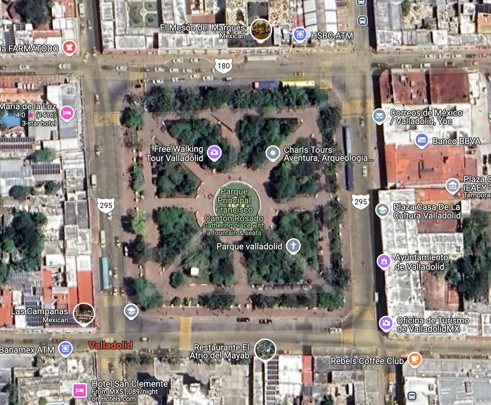
Google satellite view of the Parque Principal. The top of the photo is north. Our hotel, El Mesón de Marques, is on the north side of Highway 180 (one-way heading west) and looks south over the Parque across the street. Just west of the hotel is Centro Artesenal Zaci, the handicrafts center. The east side of the Parque is bordered by Highway 295 (one-way heading north). From north to south along this street are the Correos de Mexico (Post Office), the Casa de la Cultura (House of Culture), the Ayuntamiento (City Hall) and the Oficina de Turismo (Tourist Office). 

The street along the south side of the Parque is Highway 180 (one-way heading east), which contains some restaurants on the eastern half of the block and Templo San Servacio on the west end. The west side of the Parque is bordered by Highway 295 (one way heading south). Facing the Parque along this side is an attractive arcade with arched portales, under which are a series of commercial establishments. In the center of the Parque is the fountain with the statue of La Mestiza that you saw in Part 1 of this series.

If you take Highway 295 north, you can access the ancient Maya ruins of Ek Balam and ultimately the small, scenic port of San Felipe on Yucatan's north coast. Heading west on Highway 180 will take you to the famous ruin of Chichen Itza. Going east on 180, you will pass by another ancient city called Cobá and finally reach the coast at Tulum, where there is yet another famous Maya ruin. Heading south on 295 takes you into the interior of the Yucatan Peninsula, where there are additional Maya ruins and other historical sites. From these descriptions, you can understand the centrality of the Parque and of Valladolid itself.


Parque Principal Francisco Cantón Robles

View from the west entrance toward the fountain. Behind the trees in the background are the Ayuntamiento and Casa de Cultura. Those who built the Parque were very generous in their placement of benches and shady trees. The people who enjoy the area use it to relax, play, and to meet old friends or encounter new ones. The general atmosphere is laid-back and genial.  

The Spanish city of Valladolid was originally founded in 1543. Two years later, in 1545, it was moved about 50k (31mi) south to the Maya city of Zaci, its present location, which was re-named Valladolid. The move was opposed by the founder, Francisco Montejo el Sobrino, but the original place had been humid and full of mosquitos and many of the Spanish settlers had sickened and died. Almost no one but el Sobrino wanted to stay at the old location and he was forced to give in. From Zaci's original population of about 1000 Maya natives, the city has grown to about 56,500 today.


At the center of the Parque is the fountain with the statue called La Mestiza. The emblems on the tops of the white benches are Valladolid's coat-of-arms. For the story of La Mestiza, see Part 1 of this series. The area comprising the Parque originally contained Zaci's large pyramid, a structure that was 100 meters square at its base. The Spanish demolished the pyramid and used the materials to construct many of the present-day structures facing the Parque across the surrounding streets. 

It was typical Spanish practice to tear down temples and pyramids in places they settled. Sometimes this was done to obtain building materials for their mansions, churches and public buildings, but it was also intended to make an ideological statement. They considered the religious beliefs of the indigenous people to be "devil worship" and were determined to supplant them with Catholicism. When pyramids were too large to destroy, they would often build a church on the very top to make clear who was now in charge.


A recent rain squall had left the Parque's walkway glistening. Yucatan is surrounded on three sides by the Gulf of Mexico, the Caribbean Sea, and the body of water to the north where they meet. Weather is thus very changeable. This photo shows the western border of the Parque. The building on the right is the Ayuntamiento. The building on its left, with the arched portales on both floors, is the Casa de Cultura. 

The Spanish conquest of Yucatan was a slow process. The first contact occurred during Christopher Columbus's fourth expedition to the New World in 1502. However, the last independent Maya city-state of Tayasal was not conquered until 1695, almost 200 years later. Over the 25 years following 1502, the Spanish conducted a number of brief visits and small explorations into Yucatan. These were mostly stops by ships to refresh food and water supplies, look for gold, or to capture slaves. With only a few exceptions, these intrusions were met with fierce Maya resistance, resulting in many Spanish casualties. 


A small boy is fascinated by a large bubble floating through the air. When I took this shot, a mother behind me was blowing bubbles to entertain her child. One of these floated through the middle of the photo I was taking. I didn't realize the interesting image I had captured until later, when I downloaded the photo onto my computer. This is typical of the quirky nature of Mexican plazas.

One of the conquistadors who participated in the early explorations was Francisco Montejo. He had been the captain of one of the Spanish ships in the 1518 Juan de Grijalva expedition. He was also the uncle of Francisco Montejo el Sobrino (the Nephew), who later founded Valladolid. In addition Francisco Montejo had a son named Francisco Montejo nicknamed el Mozo (the Younger). The son participated in the conquest of Yucatan and founded Campeche, the first permanent Spanish town on the Peninsula. In order to avoid confusion I'll refer to the son and nephew as el Mozo, and el Sobrino.


Templo San Servacio stands across from the southwest corner of the Parque. The Spanish began constructing the original church with materials looted from the pyramid shortly after el Sobrino moved Valladolid's location to Zaci. However, that church was demolished in 1705 by order of the Bishop because of a crime that was committed within it. Construction of the church you see above began that same year. I'll go into the details of all this when I do my posting on Templo San Servacio.

In 1527, Spanish King Philip II gave Francisco Montejo the right to conquer Yucatan. He immediately set to work. However, the conquest of the Maya proved a much more difficult task than Hernán Cortez had with the Aztecs. This is interesting because the Aztec empire was large, unified, and could field well-trained armies of considerable size. Cortéz  conquered the Aztec empire by seizing its ruler in what amounted to a coup d'etat.  Franciso Pizarro later used the same strategy to conquer the Inca empire. Fierce fighting lasted for a few years after both coups, but the conquests were over relatively quickly. 


A man chats with a woman and her son as they bask in the winter sunshine. In the upper left, a trio of young people hang out on another bench. The scene above is typical of what you find in the Parque, or in any one of the innumerable other plazas in Mexico's towns and cities. This is a culture that, for the most part, still moves at a relaxed and leisurely pace.

The difference between the conquest of the Maya and that of the Aztec and Inca empires lies in the dispersed nature of power among the Maya, as well as in the much more difficult climate and terrain. During pre-hispanic times, there had never been a Maya empire and when the Spanish arrived, there still wasn't. The Maya of Yucatan were separated into as many as 24 different kuchkabaloob (city-states). Each city-state had to be individually conquered, and they had a bad habit of not staying conquered. Sometimes, when a town was captured, its inhabitants would just flee into the thick jungle until the Spanish left.


Strollers pass along the sidewalk of a street on the west side of the Parque. This is the side with most of the commercial establishments. The arched portales of the building above support an open-air arcade lined with numerous small businesses. The balconies along the second floor have French doors which open into offices, or possibly apartments. If you continue south on this street, you will exit the city and pass into the vast interior of the Yucatan Peninsula.

In 1540, after thirteen years of effort, Francisco Montejo turned over his right of conquest to el Mozo. The son, along with his cousin el Sobrino, energetically continued the work. The same year his father retired, el Mozo founded Campeche on the Gulf coast. He then sent his cousin north where el Sobrino defeated the Maya at the city of T'ho. In 1542, el Sobrino founded Mérida at T'ho, building the new city with materials from the temples of the old one. In 1543, el Sobrino was sent east where he conquered Zaci and founded Valladolid. Thus, within three years, Yucatan's three most important colonial cities were established.


Two Yucatecas chat on sillas tú y yo, a form of seating that may be unique to Yucatan. Sillas tú y yo ("you and me seats") are a fun and comfortable way to interact with another person. In our travels around Mexico, I can only recall seeing them in Valladolid and Mérida. Many of the older generation of Yucatecas still wear the traditional, beautifully-embroidered huipiles (sometimes spelled hipiles) on a day-to-day basis. However, most of the younger ones seem to have adopted north-of-the-border styles like shorts and t-shirts.

Even after the three colonial cities were founded, the Yucatan Peninsula's Maya people remained defiant. In spite of savage reprisals, there were repeated revolts throughout the following centuries. A couple of times, the Spanish (and later the non-Maya Mexicans) were almost driven out of the Peninsula, The greatest revolt of all was the Caste War (1847-1933). The Zapatista uprising of 1994 was the most recent echo of this centuries-long struggle. 

This completes Part 2 of my Valladolid Adventures series. I hope you enjoyed it. If so, please leave any thoughts or questions in the Comments section below or email me directly. If you leave a question, please include your email address so that I can respond in a timely manner.

Hasta luego, Jim


Thursday, February 13, 2025

Valladolid Adventures Part 1 of 22: A jewel among Yucatan's treasures

Statue on the central fountain of Parque Principal Francisco Cantón Rosado. She is called "La Mestiza" (meaning mixed Spanish and Maya) and wears an embroidered huipil, the traditional garb women in Yucatan. Manuel Cachón sculpted the statue in 1924. His original work was replaced for a time by a monument to the heroes of June 4, 1910, who ignited the Mexican Revolution. Eventually, that monument was itself replaced by this replica of the original. La Mestiza's smile epitomizes the friendly, laid-back local attitude.

In Part 1 of my Valladolid Adventures series, I will do something a little different from my past practices. I intend to briefly highlight some--but not all by far--of the fascinating things to see and do in this small city in central Yucatan. Each of these places will be covered in some depth in future parts of the series. My future postings will also cover nearby places we visited on day-trips outside Valladolid. These will include Maya sites like Ek Balam, Cobá, and Muyil, and the great colonial-era monastery at Izamal. If the Yucatan Peninsula is a treasure chest of experiences, Valladolid shines as one of the brightest jewels.

Overview

Google map of our route from Mérida to Valladolid. In January of 2017, we flew into Mérida from Guadalajara, and rented a car at the airport. We stayed the night at a nearby hotel so we would be fresh for our drive the next morning. It is a pretty straight-forward route. You head south on the highway from the airport and look for signs for the Mérida Periferico and Cancun. Once on the Periferico, you travel for 19 km (11.8 mi) or 20 minutes. Turn right at the exit for Cancun, onto the autopista Highway 180. (Alternatively, you could fly into Cancun and drive from there to Valladolid, about the same distance.)

The Highway 180 autopista (high-speed toll road) should be in excellent condition. Follow 180 for about 2 hours until you come to the exit on the right for Valladolid. From the exit, drive 5.6 km (3.5 mi) south along Highway 295 to Parque Principal in the center of the city. We stayed at Hotel Mesón Marquis, which faces the Parque's north side. There are other good hotels in Valladolid, but we chose this one because it was central and within walking distance of nearly everything we wanted to see. For a Google interactive map, click here.

Parque Principal Francisco Cantón Rosado

The fountain of La Mestiza is surrounded by a circle of benches. Walkways radiate out from the path around the circle. Through the trees on the south side of the Parque, you can see the bell towers of Templo San Servacio, Valladolid's main church. Although the Parque is generally fairly serene, there was a colorful fiesta during part of our visit, with booths selling a variety of handicrafts. In the next posting of this series, I will give you a taste of this vibrant event.

The Parque Principal stands in an area once covered by a Maya pyramid that was 100 m2 (109.3 yds2). Following the usual Spanish practice, the pyramid was demolished and its materials were used to build the City Hall, mansions for the conquistadors, and an earlier version of the Templo San Servacio, . The space left by the removal of the pyramid became Plaza de Armas, so-named because that was where the colonial militia met to drill. In 1900, the plaza became Parque Principal Francisco Cantón Rosado, named for the Governor of Yucatan who donated the fences surrounding the Parque. 

Templo San Servacio

The church resembles a fortress because it occasionally functioned as one. Notice the high walls and three vertical gun slits on each tower, placed there to be used during periodic Maya revolts. Since the Maya refused to stay conquered, the Spanish buildings had to be defensible. As mentioned above, the original church was built from materials looted from the pyramid of Zaci. That was the name of the people living in the area when the Spanish arrived. After the conquistador Francisco de Montejo el Sobrino defeated them, he named his new city Valladolid, which was the name of the city that was then capital of Spain. 

As I mentioned, the church above is not the original Templo San Servacio. That structure was demolished in 1705 on the order of the bishop, Don Pedro de los Rios Reyes, "to help erase the stain" of a crime that had been committed on its premises. In a future posting, I will detail how it was that the church came to be rebuilt in its present form. Visitors to my blog may have noticed that I spend a lot of time photographing and talking about religious structures like this one. I am not a religious person myself, but I do admire the artistry and cultural significance of Mexico's colonial heritage, as well as its pre-hispanic heritage. 

Hotel Mesón de Marques

Courtyard and swimming pool of our hotel. I took this shot from the balcony just outside of our room. This hotel was one of the nicest we have stayed at during our time in Mexico. The location of the hotel was ideal for exploring the city on foot. The staff were friendly, efficient, and helpful. One of the best aspects was the restaurant, located around another courtyard, where we ate most of our breakfasts and dinners. The food was delicious, reasonably priced, and the service was excellent. A future posting will cover this very special hotel.

The Méson de Marques (Mansion of the Marquis), was built in the 17th century for a high-level member of the Spanish aristocracy. In colonial times, the most important members of the local community built their homes facing the main plaza of a city, or along streets adjacent to it. The further out you lived, the lower your social status. The indigenous people lived on the outskirts and provided the cooks, maids, gardeners, and other servants of the wealthier classes. All this didn't happen by accident. It was the result of deliberate colonial urban planning dictated by Spanish King Phillip II in the last part of the 16th century. 

Ex-Convento San Bernardino de Siena de Sisal

View of the Ex-Convento from the right. The distant figure in the center is Carole. Construction on this Franciscan ex-convento (now a museum) began in 1552 and was completed in 1560. That's quite a rapid pace for such a large structure. In fact, it is the second largest Franciscan construction in Yucatan, covering 14,121 sq meters (15,442 sq yds). Included in the complex are the church, cloister, chapel, and orchard. The ornate retablo behind the church's main altar is particularly notable. Given the size of the complex, I will probably do more than one posting on it later in this series.

For those who viewed my recent series on the Franciscan convents in the Sierra Gorda, you will recall that the Franciscans played a major role in Mexico during the so-called "Spiritual Conquest". Some of the young Franciscans who worked in the Sierra Gorda ended up in leadership positions in the Yucatan missions later in their lives. That the Yucatan's two largest conventos were both Franciscan shows the significance of the Order's role here. Ex-Convento San Bernardino de Siena is located about 7 blocks southwest of the Parque.

Cenote Zaci

Cenote Zaci is a deep, shady, water-filled pit in the limestone crust of Yucatan. The small floating objects in the water are swimmers. The figure dressed in red by the tree on the left provides a sense of scale. Cenote Zaci is open from 8:30am to 5:30pm with a modest entrance fee of 30 pesos ($1.50 USD). There are changing rooms and restrooms as well as an adjacent restaurant. Lifejackets are also available. Only a few of Yucatan's cenotes are located so conveniently within a town. This one is just 4 blocks northwest of the Parque Principal. 

Cenotes are found throughout northern Yucatan and were the main water source for the ancient Maya civilizations that developed here. Including Cenote Zaci, Valladolid has at least two cenotes within blocks of where the Zaci pyramid once stood. Most of Yucatan is a flat, porous limestone shelf. Rainwater seeps down into it to form underground pools. The crust over some of these pools eventually erodes and collapses, leaving an open pool. The meteor that struck the coast of Yucatan 60 million years ago not only killed all the dinosaurs but created a series of concentric cracks in the limestone which helped create the cenotes.


Museo Regional San Roques

Ancient Maya stucco mask. The facial features include a rounded, chubby face, thick lips and a flattened nose. These give the mask an uncanny resemblance to those on the great stone Olmec heads found in the State of Veracruz. The Olmec heads were found hundreds of miles away from Valladolid, and their civilization died out at least 1000 years before this mask was made. I therefore found the resemblance very odd. I would be open to hearing from anyone who can enlighten me about this. The mask, along with other Maya artifacts, are displayed in the Museo Regional San Roque, about 1 block east of the Parque Principal. 

The site of the museum has a long and colorful history. It was originally a 4-bed hospital, founded as Hospital del Santo Nombre de Jesus in 1575 by Valladolid Mayor Don Diego Sarmiento de Figueroa. This evolved into the Convento de San Roque and by 1645 the hospital was the best in the province. All this has long since disappeared except for the temple to San Roque. Several historical figures are buried under the museum's courtyard, including those killed in the crime that resulted in the demolishment of the Temple of San Servacio, as well as activists executed at the beginning of the Mexican Revolution.

Iglesia Santa Ana

Iglesia de Santa Ana, seen through one of the triple arches of its front gate. This small 16th century church was originally built for the Maya natives. At that time, all services except mass were conducted in their language. Santa Ana, the church's patron, is said to be the mother of the Virgin Mary. These very early colonial structures represent a world very different from today's modern, bustling Mexico. The structure still functions as a church after 500 years. I very much appreciate the effort Mexicans take to preserve their heritage. A future posting will take a closer look at the church, both inside and out.

Part of the open space in front of the church, called the atrium, later became a neighborhood park. It was in this park that Manuel Antonio Ay was hanged on June 30, 1847. He was an early leader of the Caste War (1847-1915), a great Maya revolt that nearly drove the Spanish out of Yucatan. Today the park contains a monument to Los Heroes Niños (the Child Heroes), commemorating the cadets who died fighting the U.S. forces that had invaded Mexico in 1846. Several young cadets died defending Chapultepec Castle. One of them, rather than surrender, wrapped himself in the Mexican flag and jumped off the high parapet.

Hacienda San Lorenzo & Cenote Oxmán

The casa grande of the hacienda has been transformed into a a hotel. Hacienda San Lorenzo was constructed in 1746. There is very little information available about its early history, some sources suggest that this hacienda may have grown agave for mezcal, a liquor similar to tequila. Distilling these liquors became important in the last half of the 18th century, so production soared. In addition haciendas in this area produced corn, cattle, and sugar. Sisal, a plant native to Yucatan, was also grown at many 19th century haciendas in north central Yucatan. It was used for twine to bale wheat sheaves and for rope to rig ships. 

The hacienda has the advantage of possessing the Oxmán Cenote, one of at least two within Valladolid. This was fortunate for the original hacienda owners because there are no rivers and very little above ground water in northern Yucatan. Lack of water inhibited crop production of any but drought-resistant plants like agave and sisal. The cenote here is very similar in size and shape to Zaci Cenote. Like at Zaci, you can swim here and there were several people in the water when we visited. As you can see above, the casa grande's pool was empty, so the experience of diving into the Oxmán Cenote must have been captivating.

Centro Artesanal Zaci

Zaci's handicrafts center faces the Parque Principal, on its north side. The Centro Artesenal Zaci stands next to Hotel Mesón de Marques on its west side. It was once a the mansion of a conquistador, but it later became part of the Casa Cural (parsonage or priest's house). 

Refurbished in the 19th century, the building housed the Model Central School in 1906 and the Military Exercises Professorship in 1908. The Bolio family owned the property as a private home for a time, but in 1940 it again became a school named after local luminary Delio Moreno Cartón. In 2007, the school was moved and the Valladolid Administration opened the Centro Artesenal Zaci. (Photo from En-Yucatan website)

Casa de los Venados

"Hi! What's up? Come on in and relax!" A scary skeleton, with a somewhat off-putting expression, greeted us when we arrived at Casa de los Venados (House of the Deer). This is the home of Mr. and Mrs. John Venator, who own Mexico's largest private collection of folk art. Over 35 years, they gathered more than 3000 items, including some of the most extraordinary I have yet encountered. After we made the expected donation of $100 pesos ($5.00 USD), our Mexican guide Freddy showed us around the place. Neither the Venators nor Freddy had any problem with the considerable number of photos I took. 

John Venator retired to Yucatan after a career as a CEO of an international trade organization in Chicago. He and his wife looked at various places in both Mérida and Valladolid before buying this 18,000 square foot property. It has become both their home and their private museum. The house was largely in ruins when they purchased it, but they remodeled it over 8 years, first for vacations, then as their retirement home. Casa de los Venados is 1/2 block south of the Parque Principal. They share it with a small terrier who loves to sit on John's lap. Whatever else you decide to see in Valladolid, don't miss a visit to this place!

This completes Part 1 of my Valladolid Adventures series. In Part 2, I will show you around the Parque Principal and the colorful fiesta we encountered there. I hope you enjoyed this first part. If so, please leave any thoughts or questions in the Comments section below or email me directly. If you leave a comment, please remember to include your email address so that I can respond in a timely manner.

Hasta luego, Jim