
In this posting, I'll walk you through the Parque Principal so you can see some of the people and the typical activities that occur here. Because I got so many great shots here during our stay, I have created three separate postings. The first will be about the Parque itself. The next will show a fiesta that happened there during our visit. The third focuses on the beautiful handicrafts that were sold during the fiesta.
Overview
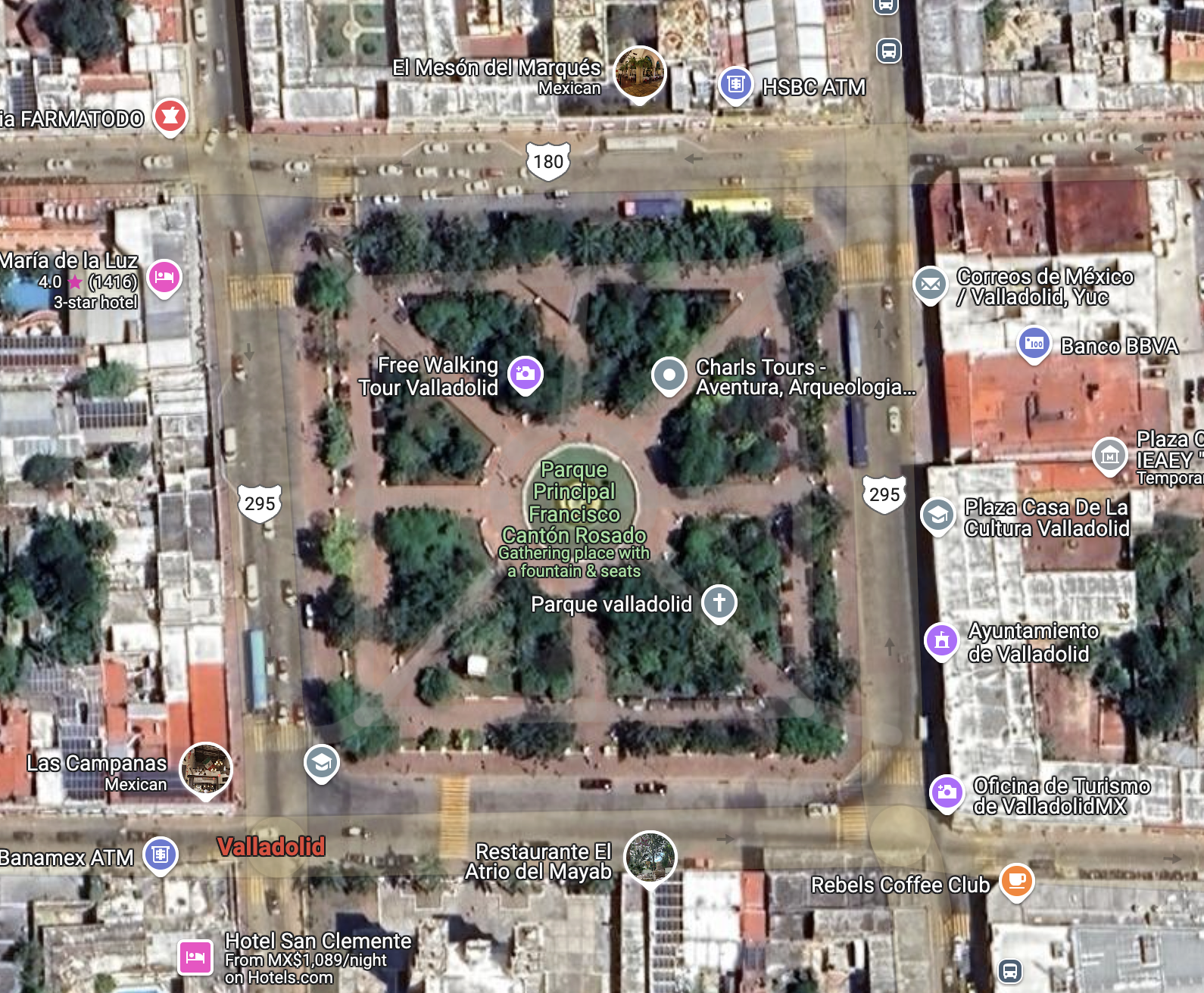
The street along the south side of the Parque is Highway 180 (one-way heading east), which contains some restaurants on the eastern half of the block and Templo San Servacio on the west end. The west side of the Parque is bordered by Highway 295 (one way heading south). Facing the Parque along this side is an attractive arcade with arched portales, under which are a series of commercial establishments. In the center of the Parque is the fountain with the statue of La Mestiza that you saw in Part 1 of this series.
If you take Highway 295 north, you can access the ancient Maya ruins of Ek Balam and ultimately the small, scenic port of San Felipe on Yucatan's north coast. Heading west on Highway 180 will take you to the famous ruin of Chichen Itza. Going east on 180, you will pass by another ancient city called Cobá and finally reach the coast at Tulum, where there is yet another famous Maya ruin. Heading south on 295 takes you into the interior of the Yucatan Peninsula, where there are additional Maya ruins and other historical sites. From these descriptions, you can understand the centrality of the Parque and of Valladolid itself.
 View from the west entrance toward the fountain. Behind the trees in the background are the Ayuntamiento and Casa de Cultura. Those who built the Parque were very generous in their placement of benches and shady trees. The people who enjoy the area use it to relax, play, and to meet old friends or encounter new ones. The general atmosphere is laid-back and genial.
 At the center of the Parque is the fountain with the statue called La Mestiza. The emblems on the tops of the white benches are Valladolid's coat-of-arms. For the story of La Mestiza, see Part 1 of this series. The area comprising the Parque originally contained Zaci's large pyramid, a structure that was 100 meters square at its base. The Spanish demolished the pyramid and used the materials to construct many of the present-day structures facing the Parque across the surrounding streets.
 A recent rain squall had left the Parque's walkway glistening. Yucatan is surrounded on three sides by the Gulf of Mexico, the Caribbean Sea, and the body of water to the north where they meet. Weather is thus very changeable. This photo shows the western border of the Parque. The building on the right is the Ayuntamiento. The building on its left, with the arched portales on both floors, is the Casa de Cultura.
 A small boy is fascinated by a large bubble floating through the air. When I took this shot, a mother behind me was blowing bubbles to entertain her child. One of these floated through the middle of the photo I was taking. I didn't realize the interesting image I had captured until later, when I downloaded the photo onto my computer. This is typical of the quirky nature of Mexican plazas.
 Templo San Servacio stands across from the southwest corner of the Parque. The Spanish began constructing the original church with materials looted from the pyramid shortly after el Sobrino moved Valladolid's location to Zaci. However, that church was demolished in 1705 by order of the Bishop because of a crime that was committed within it. Construction of the church you see above began that same year. I'll go into the details of all this when I do my posting on Templo San Servacio.
 A man chats with a woman and her son as they bask in the winter sunshine. In the upper left, a trio of young people hang out on another bench. The scene above is typical of what you find in the Parque, or in any one of the innumerable other plazas in Mexico's towns and cities. This is a culture that, for the most part, still moves at a relaxed and leisurely pace.
 Two Yucatecas chat on sillas tú y yo, a form of seating that may be unique to Yucatan. Sillas tú y yo ("you and me seats") are a fun and comfortable way to interact with another person. In our travels around Mexico, I can only recall seeing them in Valladolid and Mérida. Many of the older generation of Yucatecas still wear the traditional, beautifully-embroidered huipiles (sometimes spelled hipiles) on a day-to-day basis. However, most of the younger ones seem to have adopted north-of-the-border styles like shorts and t-shirts.
Parque Principal Francisco Cantón Robles

The Spanish city of Valladolid was originally founded in 1543. Two years later, in 1545, it was moved about 50k (31mi) south to the Maya city of Zaci, its present location, which was re-named Valladolid. The move was opposed by the founder, Francisco Montejo el Sobrino, but the original place had been humid and full of mosquitos and many of the Spanish settlers had sickened and died. Almost no one but el Sobrino wanted to stay at the old location and he was forced to give in. From Zaci's original population of about 1000 Maya natives, the city has grown to about 56,500 today.

It was typical Spanish practice to tear down temples and pyramids in places they settled. Sometimes this was done to obtain building materials for their mansions, churches and public buildings, but it was also intended to make an ideological statement. They considered the religious beliefs of the indigenous people to be "devil worship" and were determined to supplant them with Catholicism. When pyramids were too large to destroy, they would often build a church on the very top to make clear who was now in charge.

The Spanish conquest of Yucatan was a slow process. The first contact occurred during Christopher Columbus's fourth expedition to the New World in 1502. However, the last independent Maya city-state of Tayasal was not conquered until 1695, almost 200 years later. Over the 25 years following 1502, the Spanish conducted a number of brief visits and small explorations into Yucatan. These were mostly stops by ships to refresh food and water supplies, look for gold, or to capture slaves. With only a few exceptions, these intrusions were met with fierce Maya resistance, resulting in many Spanish casualties.

One of the conquistadors who participated in the early explorations was Francisco Montejo. He had been the captain of one of the Spanish ships in the 1518 Juan de Grijalva expedition. He was also the uncle of Francisco Montejo el Sobrino (the Nephew), who later founded Valladolid. In addition Francisco Montejo had a son named Francisco Montejo nicknamed el Mozo (the Younger). The son participated in the conquest of Yucatan and founded Campeche, the first permanent Spanish town on the Peninsula. In order to avoid confusion I'll refer to the son and nephew as el Mozo, and el Sobrino.

In 1527, Spanish King Philip II gave Francisco Montejo the right to conquer Yucatan. He immediately set to work. However, the conquest of the Maya proved a much more difficult task than Hernán Cortez had with the Aztecs. This is interesting because the Aztec empire was large, unified, and could field well-trained armies of considerable size. Cortéz conquered the Aztec empire by seizing its ruler in what amounted to a coup d'etat. Franciso Pizarro later used the same strategy to conquer the Inca empire. Fierce fighting lasted for a few years after both coups, but the conquests were over relatively quickly.

The difference between the conquest of the Maya and that of the Aztec and Inca empires lies in the dispersed nature of power among the Maya, as well as in the much more difficult climate and terrain. During pre-hispanic times, there had never been a Maya empire and when the Spanish arrived, there still wasn't. The Maya of Yucatan were separated into as many as 24 different kuchkabaloob (city-states). Each city-state had to be individually conquered, and they had a bad habit of not staying conquered. Sometimes, when a town was captured, its inhabitants would just flee into the thick jungle until the Spanish left.
 Strollers pass along the sidewalk of a street on the west side of the Parque. This is the side with most of the commercial establishments. The arched portales of the building above support an open-air arcade lined with numerous small businesses. The balconies along the second floor have French doors which open into offices, or possibly apartments. If you continue south on this street, you will exit the city and pass into the vast interior of the Yucatan Peninsula.

In 1540, after thirteen years of effort, Francisco Montejo turned over his right of conquest to el Mozo. The son, along with his cousin el Sobrino, energetically continued the work. The same year his father retired, el Mozo founded Campeche on the Gulf coast. He then sent his cousin north where el Sobrino defeated the Maya at the city of T'ho. In 1542, el Sobrino founded Mérida at T'ho, building the new city with materials from the temples of the old one. In 1543, el Sobrino was sent east where he conquered Zaci and founded Valladolid. Thus, within three years, Yucatan's three most important colonial cities were established.

Even after the three colonial cities were founded, the Yucatan Peninsula's Maya people remained defiant. In spite of savage reprisals, there were repeated revolts throughout the following centuries. A couple of times, the Spanish (and later the non-Maya Mexicans) were almost driven out of the Peninsula, The greatest revolt of all was the Caste War (1847-1933). The Zapatista uprising of 1994 was the most recent echo of this centuries-long struggle.
This completes Part 2 of my Valladolid Adventures series. I hope you enjoyed it. If so, please leave any thoughts or questions in the Comments section below or email me directly. If you leave a question, please include your email address so that I can respond in a timely manner.
Hasta luego, Jim
No comments:
Post a Comment
If your comment involves a question, please leave your email address so I can answer you. Thanks, Jim