Wednesday, April 20, 2022

Barcelona Part 1: A beautiful and historic city by the sea


An armored knight prays before battle. I encountered this statue when I visited Barcelona's Gothic-style Catedral de la Santa Creu i Santa Eulalia. The statue of the knight had no identifying sign, but the crown on the helmet indicates that he was probably one of the Counts of Barcelona. The steel plate armor he wears wasn't used until at least the 14th century. Before then, knights wore chain mail covered by a cloth tunic. 

This begins a series on a 2019 trip Carole and I took. Barcelona dates back to Roman times and has a wide variety of attractions. These include beautiful beaches, striking architecture, museums of art, history, and science, narrow medieval streets full of cafés and restaurants, a cable car ride to an historic mountain-top castle, boat tours of the harbor, and much more. Part 1 of my series will provide just a taste of this veritable banquet of experiences. 

Overview

Barcelona is located on the northeast coast of Spain. It is the capital of the Autonomous Community of Catalonia. Through much of the Middle Ages, Catalonia was an independent state with a powerful fleet of galleys with which it controlled much of the western Mediterranean. Barcelona is still an important Spanish seaport and its busy harbor is filled with commercial vessels, cruise ships and pleasure boats. 

The city is situated south of the Pyrenees Mountains, along an important land route to France and the rest of Europe. Barcelona has 1.6 million inhabitants within its city limits and there are a total of 4.8 million within Catalonia. The city has become a transportation hub and a major European cultural, economic, and financial center, as well as a magnet for tourists from around the world.


La Rambla

A stylish European tourist pushes her suitcase down La Rambla. The name means "The Boulevard" and it swarms with tourists like this young woman. La Rambla is a broad walkway approximately 15m (50ft) wide that is bordered on either side by single-lane, one-way streets running in opposite directions. Its eight long blocks stretch up from the Monument a Colom (Columbus Monument) at the harbor to a large central plaza known as Plaça Catalunya

Both sides of the boulevard are filled with hotels, restaurants, and shops, as well as various statues and historic sites. La Rambla forms the boundary between Barri Gotic (the Gothic Quarter) and El Raval. Both neighborhoods were part of the old medieval city, but Barri Gotic is even older, dating back to the original Roman town of Barcino

Our hotel, the Citadines Ramblas, was on the Barri Gotic side, about 1.5 blocks south of Plaça Catalunya. The hotel has all the modern conveniences and is very strategically located for foot tours. However, we found La Rambla to be mobbed with young European tourists and somewhat frenetic. Those seeking a quieter, more serene atmosphere might look for a hotel on one of the narrow pedestrian back-streets of Barri Gotic.


All four sides of Plaça Reial are lined with outdoor cafés. The square plaza can be reached from La Rambla by a short pedestrian walkway and can also be accessed from Carrer de Ferran, a street leading into Barri Gotic. Above the sidewalk cafés of Plaça Reial (Royal Plaza) are elegant four-story apartments built in the late 19th century. 

The Plaça's architect was Francesc Daniel Molina i Casamajó.  He modeled it on Plaza Garibaldi in Mexico City. In the 19th and early 20th centuries, some of Barcelona's most important families lived here. Today, its flavor is more bohemian and tourist-oriented. In addition to the many restaurants, there are also a number of popular nightclubs and concerts are sometimes performed in the plaça.

One night, Carole and I decided to try one of the restaurants here. I ordered the traditional Spanish dish called paella, made with rice, vegetables, chicken, and fish. It is cooked and served in a single flat pan. When the pan is placed it front of you it may be very hot, so be careful. Burned fingers can spoil a whole meal! Forewarned by the waiter, I was able to enjoy my feast without injury.

Barri Gotic

Barri Gotic is a tangle of pedestrian-only streets like this. Some date back to Roman times. Their narrowness, along with the height of the buildings, means deep shade for most of the day. Given the warmth of Barcelona's summer, the shade was a welcome relief. As Carole and I wandered these old streets, we encountered antiquity side-by-side with modernity. Medieval fountains burbled next to internet cafés. 

The narrow streets are a product of the city's Roman and medieval history. In those periods, the buildings of the town were crowded together within high stone walls as protection against attack. The central area of Barri Gotic was once the Roman seaport of Barcino, built at the end of the 1st century BC. Portions of Barcino's defensive walls and bastions, as well as sections of its aqueducts, can still be seen in various places.


This large ceramic globe once stored wine in a Roman shop. The shop pressed grapes, processed them into wine, and stored it in this and several similar globes. The wine shop once stood along a street that included other establishments which processed fish, wove textiles, and produced other goods. All these were either exported or sold to local residents. 

Barcino was founded by Caesar Augustus sometime between 15-10 BC. The remains of the street and its shops were discovered during an archeological excavation beneath the Plaça del Rei (Plaza of the King). The plaza is bordered by the Palau Padéllas, a medieval palace that now houses the Museum of the History of the City of Barcelona. 

Carole and I walked through the dimly-lighted underground rooms beneath the Plaça del Rei which contain the ruins. The shadowy walls, doorways, columns, and other structures created an eerie experience. It was like walking through a time portal into a ghostly world. Seeing the same things on the surface, in bright sunlight, would have been completely different experience. 


El Raval

Sant Pau del Camp is the oldest church in BarcelonaThe church is located in El Raval, the neighborhood on the western side of La Rambla The Romanesque structure dates back as far as 897 AD, but the site was once occupied by a 5th century Christian hospice. Sant Pau del Camp (St. Paul of the Field) is believed to have been established by Count Wilfred II, who ruled Barcelona in the Late Dark Ages. His father was Wilfred I, who founded Catalonia in 878 AD. 

The thick walls and central tower create the impression of a stronghold. Inside, the barrel-vaulted ceilings, tiny windows, and stark simplicity seem to confirm the feeling. The church, along with its monastic cloister and chapter house, originally stood outside the city walls in a camp ("field"). Its builders may well have had defense in mind when they constructed it.

I first visited the church alone and photographed its exterior. Later, I returned with Carole to check out the interior because she has a particular fondness for Romanesque art and architecture. There were only a handful of other tourists during the return visit and this enhanced the experience greatly. 


El Raval shows another face. When I visited the area, I decided to check out La Rambla del Raval. The five-block-long, tree-lined boulevard is located in the center of El Raval. Among other attractions, it contains this large, whimsical sculpture. The cat was crafted by the acclaimed artist Fernando Botero and looks like an escapee from Alice in Wonderland.

El Raval is an area where medieval structures like Sant Pau del Camp and the Antic Hospital de la Santa Creu rub shoulders with museums displaying modern art like the Museu de Arte Contemporani de Barcelona (MACBA). In between, you can find many bohemian restaurants, bars, and cafés. While El Raval is reputed to be infested with teams of pickpockets, we encountered no problems during our visit. 


La Ribera

Santa Maria del Mar, viewed from Carrer de Argenteria. While the afternoon sun was bright on the church, the street called Carrer de Argenteria was in deep shade. This magnificent church has many beautiful architectural details which I'll show in a future posting. The neighborhood called La Ribera (The Shore) is southeast of Barri Gotic, near the harbor. The proximity to the harbor probably accounts for del Mar ("of the sea") in the name of the church. 

La Ribera also contains the Museu Picasso and this was one of our priorities. Carole is very interested in Picasso and we had previously visited a museum devoted to him in Paris. Barcelona's museum is contained in a building made up of five Gothic palaces dating from the 13th-15th centuries. The museum's collection focuses on Picasso's early work, particularly during the time he lived in Barcelona.


Busy sidewalk café in La Ribera. Like the Gothic Quarter, La Ribera has many narrow streets dating back to the medieval period. It seemed like every time we emerged from one of these streets, we would encounter yet another tiny plaza filled with umbrellas-shaded tables, and waiters eager to serve coffee, food, or drinks. Barcelona is definitely your town if you want to lead a "café life". The biggest problem was choosing which among them suited our mood at the moment.


Parc de la Ciutadella

Spouts of water plunge from the mouths of griffins into a large pool. A griffin is a mythical creature, part lion and part winged dragon. They adorn a magnificent waterfall structure called La Cascada in Parc de la Ciutadella.  The large park is located several blocks east of Barri Gotic and La Ribera. 

The waterworks were designed by Antoni Gaudi in the 1870s. Gaudi later became a world famous architect whose works appears all over Barcelona. La Cascada's several levels of waterfalls include numerous other statues from Greek and Roman mythology. At the very top is Aurora, the goddess of dawn, riding a golden chariot drawn by four gold horses. 


A wooly mammoth with huge tusks never fails to fascinate kids. The mammoth is tucked away in a small clearing surrounded by woods. Kids find the long trunk to be an irresistible perch. The mammoth and La Cascada are only two of the park's many attractions. There are museums of zoology, geology, and archeology, a zoo, a boating lake, wonderful gardens, and the Parlement de Catalunya. We spent several hours here, but to see it all we would have needed a full day, or even two. 


Malecon & Harbor 

Fish swim through coral in the Aquarium de Barcelona. The Aquarium is located on the Moll España in the marina. Its tanks contain a wide variety of salt water fish, including manta rays, sharks, and moray eels. The Moll is shaped like a short-handled hockey stick, with a large grassy plaça on the handle and the Aquarium, sailboat docks, a shopping mall and other attractions on the "business end" of the stick.

Other places of interest in the marina and harbor area include the Museu Maritim, the Museu d'Históra de Catalunya, the Malecon (a broad walkway along the shore), the tour boats of Las Golondrinas, a cable car ride across the harbor, and several long beaches. There are also many restaurants and bars throughout the area.


Platja de la Barceloneta, looking northeast. Summers in Barcelona are quite warm, so the platjas (beaches) swarm with people enjoying the cool water and breezes. Barcelona's platjas lie north of the busy industrial area of the harbor. Some, like the one above, are long and broad. Others, further up the shore, are smaller and a bit more secluded. This being Europe, people (mostly young) thought nothing of stripping bare to wash off the sand and sweat at one of the public showers along the beach.


Montjuic

A cable car rises up the side of Montjuic. The top of Montjuic can easily be reached without an automobile. First, you take the light-rail Funicular de Montjuic, then hop aboard a cable car like the one above. The views are spectacular in all directions. Montjuic means Jewish Mountain, referring to the Jewish cemetery that existed here in the Middle Ages. The "mountain" is actually a large hill that overlooks Barcelona and its harbor and is visible from everywhere in the city.

Rock from Montjuic was quarried in ancient times to build the city. In the Middle Ages, the hill became the site of a lookout tower which signaled the approach of ships. In the 17th century, a fortress was built at the very top to guard against attacks by sea and revolts by the local population. In the 1960s, Castell de Montjuic (Montjuic Castle) was transformed into a museum. Over the years several other museums, art galleries and lush gardens have been built on its slopes.


Carole walks along the battlements of Castell de Montjuic. The barrel of a 20th century coast artillery gun points out to sea while, in the background, a watchtower overlooks both the coast and the city. The beauty and serenity of the Castell's view contrasts with its dark history. In addition to serving as a military strongpoint, the Castell has also functioned as a prison, particularly for political detainees. Torture and political executions were carried out here as recently as the 1930s, during Spanish Civil War. 

After touring this impressive fortification, Carole and I decided to walk down Montjuic rather than return by cable car and funicular. By doing so, we were able to visit the Fundacio Joan Miró (an art museum) and the Museu Archeológic on the path down. We ended up at the Palau Nacional (MNAC), a huge art museum near the bottom of Montjuic. After all that, we didn't have time to visit the Museu Etnológic, the two big botanic gardens, or several smaller points of interest. Maybe next time?

Montserrat

The monastery of Montserrat nestles in a small canyon. Monetsir de Santa Cecilia de Montserrat was officially founded in 1025 AD. However, religious hermits had inhabited caves on the rugged, rocky mountain in previous centuries. The Benedictine monastery is located 61km (38mi) northeast of Barcelona in the Parc Natural de la Muntanya de Montserrat. The Parc encompasses a large portion of Montserrat, whose name means "serrated mountain". 

We went on a group tour by bus from Barcelona to the base of the mountain. From there we took a funicular up to the monastery. The site can also be reached by cable car or by a serpentine walking path. Whatever mode of transportation you choose, the views of the vertical cliffs and deep valleys are breathtaking. For those who love hiking (like me) there are also paths from the monastery to higher points on the mountain. 


The basilica of the monastery is filled with religious art treasures. The church was originally built in the 16th century, but was destroyed by Napoleon's troops in 1811, when the French occupied Spain. Reconstruction began almost immediately, resulting in the basilica we see today. The most famous art treasure is the Black Madonna on the main altar. According to legend, she was carved at the start of the Christian era. In 1844, she was declared patroness of Catalonia.

The church takes its shape from the ancient Roman basilicas, which were used for public meetings and as courts of justice. Roman basilicas were long, rectangular buildings supported by columns, with a semi-circular apse at one end. When Emperor Constantine I recognized Christianity as Rome's official religion, the basilica style was adopted for churches and has been used ever since.

This completes Part 1 of my Barcelona series. What I have shown above is a tiny portion of all we saw during our visit. What we had time to see was nowhere near all there is to Barcelona. I hope you have enjoyed this posting and, if so, please leave any thoughts or questions in the Comments section below or email me directly.

Hasta luego, Jim


Monday, March 14, 2022

Peralta Part 3 of 3: The Ancient People

Teotihuacán-style mask found in a burial at Peralta. Stone masks like this are closely associated with the Teotihuacán empire (100-650 AD). The history of that empire overlapped the first three hundred years of Peralta's history (300-900 AD). Trade between the two was extensive and this led to cultural exchanges, including the use of stone masks in burials.

In this third and final part of my Peralta series, we'll take a look at artifacts from the site's museum that illuminate various aspects of the life of Peralta's ancient inhabitants. These will include objects of daily life, trade practices, burial practices, and how the city came to be abandoned. To locate Peralta, see Part 1.

Overview

The author, perusing a display at Museo de Peralta. The museum is located near the site's parking lot. It is here that you pay the modest $39 peso ($1.86 USD) fee prior to visiting the ruins. The display above explains some of the history and culture of El Bajio (The Lowland). 

El Bajio is the region between Querétaro and Jalisco from east to west, and from the mountains of Guanajuato in the north to those of Michoacan in the south. During the Classic and Epi-Classic periods (100-900 AD), the region was thickly settled. It contained a number of substantial cities, including Peralta with its 10,000 inhabitants. 


Artifacts of daily life

Ceramic items like this were used to prepare and serve food. The plate demonstrates the high level of artistry of pre-hispanic potters. Cultivated plants provided food staples such as maiz (corn), beans, squash, chiles and amaranth. Together, these provided a remarkably balanced and healthy diet.

Maiz was so important to pre-hispanic societies that it appears prominently in many creation myths. From it, the ancient people made tortillas, tamales, gruel, and a drink called atole. Only a handful of animals were domesticated for food, including turkeys and dogs. People supplemented their diets with wild plants, as well as game animals such as deer, rabbits, birds, and insects. 


A bowl with an unusual base caught my eye. I have not seen a bowl set on a base like this at any other ancient site I have visited. Most of the pottery and other artifacts in the displays were recovered from tombs or burial sites. Ceramics like this left on the surface stood little chance of surviving over the millennia. This makes the discovery of intact tombs an especially important source of information about ancient cultures.

Grave robbing is the bane of archeology. Often, robbers will smash pottery to see if valuables are stored inside. Even when stolen items are intact, they will have lost the context in which they were recovered. Cultural information can be inferred from the positions of objects in relation to one another. The level soil in which they were discovered can reveal time frames. Looting destroys all this. 


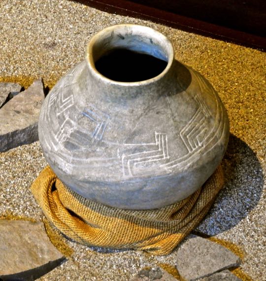
Pots were sometimes etched with abstract designs. Ceramics were decorated in a variety of ways that included etching of designs like this or painting with human or animal scenes. Pots like this might be created for domestic use or for local or long-distance trade. Ceramics might also be brought in from elsewhere as trade items. There is much more pottery on displayed at the museum than I have space to show here.


Whistles were used during dance performances and rituals. These were carved from bone, but others were crafted from wood or clay. Wind instruments like whistles were sometimes used in rituals associated with the Wind God Ehecatl, one of the most important deities worshipped at Peralta. A large Circular Structure devoted to Ehecatl was found within the Recinto de los Gobernantes (Enclosure of the Governors). See Part 1 for more details.

In addition to religious rituals, whistles were used by hunters to mimic animal noises and by warriors to terrify enemies with shrieking sounds. Curanderos (healers) used them to induce a dream-state in order to treat certain illnesses. They were also employed in death rituals related to human sacrifice. Although modern scientists are able to produce sounds using these ancient instruments, they don't really know what the music played on them sounded like.


Tobacco was smoked in bone pipesThe pipes above show that tobacco was definitely used at Peralta. In fact, the use of tobacco in the Americas goes back at least 12,300 years. Pre-hispanic people used tobacco for religious rites, as medicine for earaches and toothaches, as a trade good, for ceremonial gifts, and sometimes as a medium of exchange.


Obsidian arrow heads have been found in various sizes. Obsidian can be crafted into a wide variety of tools and weapons, including arrowheads. The edge of this volcanic glass can be sharper than modern surgical steel. The arrowheads above were likely used for hunting. The smallest would have been for birds and other small animals, while the larger ones were for deer, peccary, or other large game. The tip of the one on the lower right is broken off, possibly from hitting bone.

Trade and trade routes

Porters were used to haul a variety of trade goods. The painting above is a detail from the work of an indigenous artist shortly after the Spanish arrived. The lack of pack animals in pre-hispanic times meant that human porters usually carried trade goods. Interestingly, some of the porters above are approaching boats, possibly to utilize water transport. The Rio Lerma passes near Peralta and is navigable by small boats on much of its 750km (450mi) length. 

Mesoamerican trade routes stretched from New Mexico to Honduras and reached both the Pacific Coast and the Caribbean. One region where many of them crossed was El Bajio. The merchants who organized the caravans had their own god, whose painted image decorates the walls of the Epi-Classic city of Cacaxtla (near Puebla), a contemporary of Peralta. While it was well-nourished by its fields of maiz, beans, and squash, trade made  Peralta rich.


Obsidian cores and tools. A core is a chunk of raw obsidian. By carefully striking it, large flakes can be removed. Further striking can then transform the flakes into various sharp-edged instruments. Millennia of practice enabled ancient people to fairly quickly produce tools and weapons or to replace those that were lost or broken.

The obsidian trade was as important to pre-hispanic societies as the oil trade is for modern countries. A significant source of the volcanic glass has been found near present-day Penjamo, only about 33km (20mi) from Peralta. Scientific analysis of an obsidian tool found in Texas showed that the volcanic glass from which it was crafted may have come from Penjamo, demonstrating the extent of the pre-hispanic trade networks. 


Painted bowls were traded widely in Mesoamerica. Although ceramics are both weighty and fragile, they were also a major trade item. In fact, archeologists have long used pottery and potsherds as markers to understand trade between different city-states. Whole systems have been developed for naming different cultural phases according to pottery styles and for tracing the influence of one culture on another.

Bowls like the one above would have been considered luxury goods. With careful packing and handling, they would have been worth risking on a long trek. Elites shopping in the markets in distant city-states practiced conspicuous consumption, just as modern people do. Assuming the breakage was not significant, traveling merchants could make a healthy profit on their pottery.

Burial rituals

Human remains and grave goods recovered from an elite burial. The tomb was discovered within the Recinto de los Gobernantes. This gravesite was one of most important discoveries at Peralta because of the quantity and diversity of objects recovered. These included decorated pots, necklaces, wooden items, and knives and projectile points made from obsidian.

In some Mesoamerican societies, artificial cranial deformation was practiced. Elite families would bind the skulls of their infant children with wood and leather. This was done to elongate the skull so that, as an adult, the person would appear different from commoners. However, the adult skull in this burial shows no sign of elongation. This suggests that the practice was not followed by Peralta's elites. 


Large urn recovered from a tomb.  The style of the urn indicates that it was created as a grave good, rather than for practical use. This is a very old tradition in pre-hispanic western Mexico and is frequently found in El Bajio tombs. The damage on the side of the urn may have come from a partial collapse of the tomb. 

Urns were sometimes used for what archeologists call "secondary burials". Sometime after the original burial, bones would be collected and reburied elsewhere, often within a pot like this. The purposes and meanings of pre-hispanic secondary burials are not well understood and may have varied from society to society, as well as over time.


Teotihuacán masks were not meant to be worn by the living. They are too heavy and lack carved-out backsides to fit a human face. They were death offerings, meant to be placed in a shrine or tomb. Teotihuacan masks are easily recognizable because of their similarity. They are genderless, with wide-open eyes and mouths and a straight nose. Now empty, the eyeholes once contained white shells and black onyx to imitate eyes and the mouth had teeth made of bone. 

I have seen scores of masks like this at sites all over Mexico. Their close similarity suggested to me that they were not the creations of individual craftsmen but mass produced. In fact, recent scientific investigation shows that Teotihuacan manufactured them on a large scale, but at a site far from the capital city. Production occurred in the state of Puebla, possibly at the ancient city of Cholula. 

The end of Peralta: drought, invasion, or both?

Chicomoztoc appears in many Mesoamerican migration myths. During the last part of the 10th century, waves of fierce nomads from the northern deserts began to migrate south. Some tribes passed through El Bajio, seeking to escape a decades-long drought. Collectively, these Nahuatl-speakers were known as Chichimeca ("barbarians"). When they arrived in El Bajio, the drought had already caused crop failures and famines. It was at this time--around 900 AD--that cities like Peralta were abandoned. 

Chicomoztoc ("Place of the Seven Caves") appears in the origin myths of several Chichimeca tribes. The drawing above is from a 1550 AD depiction by one tribesman. In the myths, Chicomoztoc is usually described as a mountain containing a multi-chambered cave. It was the origin point, or at least a stop-over, on a great migration. In the tribesman's drawing, each of the chambers contains a different tribe. In some versions, the tribes departed separately over time. 

The Mexica (Aztec) version is the most famous. Even after they had won an empire, they still glorified their Chichimeca origins in the last great pre-hispanic wave of migrants. However, the myth may date back at least 600 years prior to the Mexica. In fact, each of the three great pyramids of Teotihuacán represents a mountain and each has a man-made cave beneath it. Some even have multiple chambers. The location of Chicomoztoc, if it actually exists, remains a mystery.


Chichimeca warriors attack a pre-hispanic city. Like Peralta, this city sits on a hilltop, surrounded by a wall similar to that of the Recinto de los Gobernantes. Also like Peralta, the hillside is covered with cactus and maguey plants. Winding around to the left of the hill is a river which could very well have been the Lerma, which passes near Peralta. Defenders stand behind the wall, fending off attacks from all directions. 

On the hillsides, some of the Chichimeca warriors aim obsidian-tipped arrows at the defenders. Others wave weapons called macuahuitls. These flat, wooden swords had edges filled by razor-sharp obsidian blades. In their other hands, the warriors hold up circular shields. This painting was created by an indigenous artist after the Spanish arrival, but is probably an accurate portrayal of pre-hispanic warfare at the time of the Chichimeca invasion of El Bajio.


Human skull, shortly after it was unearthed. What happened to Peralta's inhabitants? Were they massacred and their city razed? There is clear evidence of such destruction at about the same time at other Epi-Classic cities such as La Quemada ("The Burned Place"). The Spanish gave its ruins that name because the great conflagration that destroyed the city was still evident after 600 years. 

The defensive hilltop position and strong walls of the Recinto de los Gobernantes showed that its builders anticipated such attacks and may have experienced some. To date, archeologists have not unearthed evidence of destruction at Peralta similar to what had happened at La Quemada. However, news of the fates of La Quemada and other Epi-Classic cities such as Xochicalco, Cantona, and Cacaxtla would have spread rapidly across Mesoamerica. 

Such frightening news, combined with economic collapse caused by drought and the disruption of the Epi-Classic trade networks, may have resulted in a panicked flight to safer locales. One of those places could have been the rising Toltec state at Tula, in today's Hidalgo state. Lacking written records, we just don't know. What we do know is that El Bajio was depopulated within a few decades. Except for scattered bands of nomads, it remained empty for the next 600 years.

This ends Part 3 of my Peralta series and completes the series itself. I hope you enjoyed it. If so, please leave any thoughts or questions in the Comments section below. If you do leave a question, please be sure to include your email address so that I may respond in a timely manner.

Hasta luego, Jim


Saturday, March 5, 2022

Peralta Part 2 of 3: The Sunken Patios and the Double Temple Complex

My friend Vinnie, on a pyramid staircase. The staircase ascends the largest of the two pyramid-temples of the Double Temple Complex, which is part of the ruins of the ancient city of Peralta. The city is located in the region of Guanajuato known as El Bajio (The Lowlands). Vinnie and I traveled there in February of 2022 on a photographic expedition.

In this part of my Peralta series, I will first show several of the features located to the west of the Recinto de los Gobernantes (The Governors' Enclosure). We'll then move on to the Double Temple Complex. For those who might want to visit Peralta, see the directions in Part 1.

Overview:

Google satellite view of the Peralta ruins. North is toward the top of the photo. Two sunken patios stand to the west of the Recinto. Sunken Patio #2 is the square to the left of the Circular Structure visible in the photo above. Sunken Patio #1 is located to the south of #2, near the southwest corner of the Recinto.

The Double Temple Complex is about 30m (100yds) to the northwest of the Recinto. It is composed of two pyramid-temples that form two of the sides of another sunken patio. The pyramid on the east side of the patio is the largest. A smaller pyramid on the south side adjoins it at the south east corner of the sunken patio. Sunken patios and plazas are one of the characteristic features of the architecture found in El Bajio's ancient cities. (Photo from Google satellite view)

The Recinto's west wall and the Sunken Patios

The Recinto's west wall, viewed from its southwest corner. Sunken Patio #1 is to the left of the Nopal cactus. At this point the wall is about 3m (10ft) high and extends 137m (450ft) to the north. The Recinto de los Gobernantes is the largest structure of its kind found in any of the ancient cities of El Bajio


The Recinto and Sunken Patio stairs. A three-step staircase in the foreground leads down into Sunken Patio #2, from which this shot was taken. The main staircase originally rose to the top of the Recinto's west side and gave access to the Circular Structure, the Ceremonial Pool, and the elite residences (see Part 1). 

The restoration workers who rebuilt this staircase chose not to complete it to the top, possibly to discourage climbers. Presently, the only access to the interior of the Recinto is on the south side. The platform was built on sloping ground, so that the wall is higher in some sections than others. At this point it stands about 7m (20ft) tall. 


Sunken Patio #1 viewed from its northwest corner. The Recinto's west wall can be seen in the background. Sunken Patio #1 is approximately 1m (3.3ft) deep and is roughly 7m (20ft) on a side. The most important features of the Recinto are located on top of, or attached to, its west side wall. This includes the main staircase. The two Sunken Patios probably were probably used by the high priest and other elites for preliminary ceremonies prior to their ascent of the staircase. 


Sunken Patio #2 is larger and shallower than its counterpart. While it is at least 20m (60ft) on a side, it is only about 2/3m (2ft) deep. In this shot you can clearly see the relationship between the patio and the main staircase of the Recinto. The sole staircase leading into and out of Patio 2 is directly below the west wall's staircase.


Indigenous dancers. While this is a modern person, his attire would have been familiar to the performers who danced in Peralta's sunken plazas and patios 1400 years ago. Like him, they would have been festooned with bright feathers and armed with rattles made of seed pods filled with small stones. Some dancers, like one of those behind this man, would have worn ankle rattles made from similar seed pods. (Photo from the Tres Reyes Fiesta of Cajititlán, Jalisco). 

It is easy to imagine Peralta's ancient dancers twirling and stamping the ground, making a rhythmic sound with their rattles. Drums carved from hollow logs would have boomed, while the eerie, mournful tones of conch shell trumpets would have filled the air.  Bone flutes and wooden whistles would have added their shrill sounds. All these kinds of instruments have been unearthed in ancient burial sites all over Mexcio. 


The Double Temple Complex

The Double Temple Complex, looking south. The larger stepped-pyramid on the east (left) has six levels and may have originally had more. Its sole staircase is on its west side, leading down into the Sunken Patio below. The smaller pyramid on the south side has three stepped levels. A ruined structure on top may have once formed a fourth level. Its only staircase also ends in the patio, but is wider than that of the east side pyramid. (Aerial photo from Wikipedia).

The outside dimensions of the Double Temple Complex measure 85m (279ft) from east to west and 79m (259ft) from north to south. The top of the east side pyramid, which is the highest point in the complex, rises to 12m (39ft). Although the Double Temple Complex is smaller than the Recinto de los Gobernantes, it is every bit as intriguing. Its function appears to be entirely religious/ceremonial. No traces have been found of any dwellings within the complex.


The author, approaching the south side of the Double Temple Complex. At the point where the two pyramids adjoin, a staircase leads up to a small platform from which the sunken patio can be viewed. My previous experience at this site taught me that the best photos here would be achieved from a height, rather than from ground level. (Photo by Vinnie Heptig)


View of the stepped levels of the south side of the eastern pyramid. After carefully picking my way up, my effort was rewarded. Visible to the east are the beautifully reconstructed stepped-levels of the larger pyramid's south face. In ancient times, these walls would have been covered by brightly-painted plaster. 


The front of the smaller pyramid faces north, into the sunken patio. Turning left (west), I could see the smaller pyramid's first three levels, along with its staircase. This structure seemed more crudely constructed than its counterpart, indicating that it may have been built at an earlier time. While the south and east sides of the patio are bordered by the two pyramids, the west and north sides are enclosed by stone walls.


View to the north, along the west side of the larger pyramid. The perimeter wall on the north side of the sunken patio can be seen in the distance. This pyramid's only staircase can be seen about half way along the length of the wall. In order to explore the Double Temple Complex from here, I had to make a choice. 

I could descend another set of rough stairs below where I stood down into the patio. Alternatively, I could walk along the narrow ledge across the face of this pyramid to its stairs. The ledge was only about 0.25m (10in) wide, but it looked solid and reasonably safe, assuming I stepped carefully. Vinnie, who had come up from behind, watched my progress and decided the rough stairs to the patio looked safer. 


Descending the east pyramid's staircase. After traversing the ledge in the upper right, I began to descend. Although the lower part of the staircase was well-restored, the section I was climbing down in this photo was still pretty rough. Fortunately, I could use my hiking pole to balance myself and to test the stability of the rocks.

Vinnie was standing in the small platform I had just left when he took this shot of me. I wondered at the time if he was secretly hoping to capture a spectacular tumble. He congratulated me when I reached the bottom, but I thought I detected of trace of disappointment. (Photo by Vinnie Heptig)


View of the sunken patio and pyramids from the west wall. The Circular structure within the Recinto de los Gobernantes (see Part 1) was clearly built to worship Ehecatl, the Wind God. However, it is not clear which gods were being honored when these two pyramids were built. What is clear is that the Double Pyramid Complex is oriented to the Cardinal Directions.  

A high priest who ascended the west-facing pyramid would be facing east, toward the sacred direction of sunrise when he reached the top. In addition, the tops of both pyramids would have provided excellent views of dances and other ceremonies performed in the patio below. They would also have made good speaking platforms to address the people assembled below. (Photo by Vinnie Heptig)


Artist's conception of a ceremonial dance. The view here is from the southwest corner of the patio, near the place where I originally ascended. As mentioned before, the stepped levels of the pyramids and the walls of the sunken patio were once covered by plaster and painted with designs. (Photo from Peralta Museum display)


The staircase of the larger pyramid shows several phases of construction. The lower stairs are the most recent. Previous stages can be seen as you ascend, with the oldest section near the top. In ancient times, new structures were built over top of previous ones. New rulers often sought to make a statement about their power through architectural upgrades.


The architectural influence of Teotihuacán can be seen here. The talud y tablero (slope and tablet) style can be seen along the front of the pyramid. Peralta was settled approximately 300 AD, during the height of Teotihuacán's power (100-650 AD). This is one of many indications of the cultural and economic exchanges between that great empire and the cities of El Bajio


The south pyramid, viewed from the ledge on the east pyramid's face. From here, you can see three levels of the south pyramid and some rubble from a fourth. Also visible are more talud y tablero features on its second level. The rough staircase by which Vinnie descended to the patio can be seen on the left. The rubble on the top of the pyramid was probably once a temple.


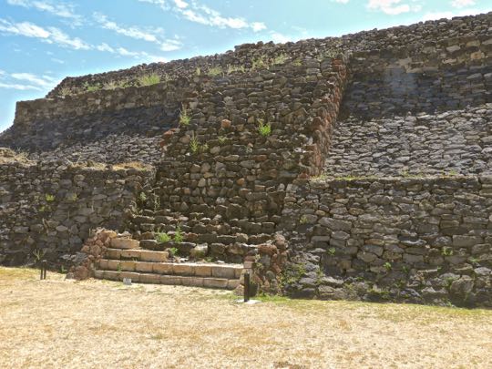
Staircase of the south pyramid. Only the bottom two steps have been fully restored. Peralta and the other cities of El Bajio reached their apogee between 700-800 AD. This was during the Epi-Classic era, following the fall of Teotihuacán and early in the rise of the Toltec empire (700-1100 AD).


The north side of the Double Temple Complex. This side of the eastern pyramid shows five of its six remaining levels. The sunken patio of the Double Temple Complex and those found elsewhere in Peralta are among more than 200 examples of this feature that have been found throughout El Bajio. This has led some archeologists to dub the civilization that created these architectural features "the sunken patio culture".

Peralta was in decline by the late 10th century, due to deforestation and overpopulation. A study of tree rings shows that between 897 and 922 AD a great drought parched north and central Mexico, causing major famines and economic disruption. Even worse, it forced the fierce nomads of the northern deserts to migrate south and Peralta was in their path. By 900 AD, the city was deserted. Except for scattered bands of nomads, the region remained empty for the next 600 years.

This completes Part 2 of my three-part series on Peralta. In the next part, I will show you some of the fascinating artifacts left by the people who once lived here. I hope you enjoyed Part 2. If so, please leave any thoughts or questions in the Comments section below, or email me directly. If you leave a question in the Comments section, please include your email address so that I may reply in a timely way.

Hasta luego, Jim