Wednesday, September 1, 2021

Mexico's Bajio region and the ancient city of Plazuelas

South side of Plazuelas' Basamento Oriente. The Basamento Oriente (East Structure) is a pyramid-temple on a broad platform containing several similar structures. The ancient site of Plazuelas is not large, but it has a number of fascinating features displaying a variety of architectural styles. Above, you can see the talud y tablera (slope and tablet) style, which links Plazuela with architectural traditions of Teotihuacán.

This posting was originally intended as the first of a three-part series, including ruins of the cities of Peralta and Cañada de la VirgenI visited and photographed all three sites several years ago. Unfortunately, a hard drive crash wiped out the photos of the other two cities, leaving me with only those from Plazuelas

The three cities are all located in a region of central-western Mexico known as El Bajio (The Lowlands). Until the late 20th century, archeologists thought the area contained few if any ancient ruins. They couldn't have been more wrong. In order to understand the role played by Plazuelas and the other cities, it is first necessary to talk about El Bajio.

Overview

Mexico's Bajio Region, outlined in red. El Bajio is a broad basin that is bordered by the mountains of Michoacan in the south, Los Altos (The Highlands) of Jalisco and Aguascalientes in the west, the mountains of Guanajuato in the north, and the highlands of Querétaro in the east. When the Spanish arrived in the early 16th century, the area was populated only by scattered groups of fierce hunter-gatherer nomads known as Chichimeca

As a result, the region came to be known as the Gran ChichimecaBoth the Aztecs and the Spanish considered it to be empty, dangerous, and of little value. That had been El Bajio's reputation for the previous 600 years. However, in the Pre-Classic era (400 BC-250 AD), the area had contained numerous settlements of a culture known as the ChupicuaroThis was enabled by rich lands well-watered by the Lerma and Laja rivers.

During the Classic era (250-600 AD), El Bajio's population grew rapidly. Cities of significant size with sophisticated architecture began to appear. Defensive fortifications also appeared, indicating the presence of hostile forces. Teotihuacán was the dominant power in this era, and architecture and cultural artifacts have been found in many places. Then, around 600 AD, the great trading empire of Teotihuacán  fell, possibly from an internal uprising. This ended the Classic era and began the Epi-Classic.

El Bajio really came into its own during the Epi-Classic (600-900 AD). During that era, regional powers sprang up all over Mexico to fill the political and economic vacuum left by Teotihuacán's fall.  These included cities like Xochicalco, Cacaxtla, and La Quemada. El Bajio was important because the trade routes of these far-flung regional powers all ran through it. This was of great advantage to the growth and development of Plazuelas. 


Scale model of Plazuelas. The ceremonial and elite residential areas were located on three sloping plateaus, separated by two deep ravines, Los Cuijes to the west and Agua Nacido on the east. The ceremonial center is on the central plateau, surrounded by the ravines and the steep cliff at its southern base. The elite lived on the east and west plateaus, while the common people lived near the fields in the valley below. Most of the city's water came from Agua Nacido's year-round spring. A broken 2.6m (8.5ft) stone phallus representing fertility was discovered at the base of the west plateau.

The Epi-Classic was a period of conflict and militarism among the regional powers, as is usually the case after the fall of great empires. An example of this can be found on the huge mural of a gory battle at the city of CacaxtlaAs a consequence, all of the Epi-Classic cities I have visited occupy carefully planned defensive positions. At Plazuelas, the cliffs and ravines would have provided a considerable advantage to defenders and greatly hindered those who might attack.

While Plazuelas' position in El Bajio was advantageous for trade, it also involved disadvantages. Envious powers might attack, seeking to control its trade routes. In addition, numerous Chichimeca migrations from the north had occurred over the centuries and Plazuelas was squarely in the path of these invasions. At the end of the Epi-Classic, the city was sacked, burned, and abandoned, apparently as the result of one of these threats.


Assorted ceramics in Plazuelas' museum. At the base of the cliff below the ceremonial center is a museum with many artifacts from the ancient city. These show that Plazuelas was indeed a cultural crossroads. Some of the ceramics and other pieces originated in far distant places. Others may have been produced locally, but show the influence of different cultures. Traveling merchants were so important that they had their own god, who can be seen on a mural at Cacaxtla.

Along trails worn by centuries of footsteps, the merchants trudged into Plazuelas from the north, west, east, and south. They were usually accompanied by lines of heavily laden porters, since baggage animals didn't exist in Mexico until the Spanish arrival. The porters carried beautifully painted ceramic pots, bowls, and plates, all carefully cushioned in wood-frame packs.  These were crafted in the workshops of cities throughout Mesoamerica.

Also to be found in those packs: turquoise from the deserts of the American Southwest; conches and other seashells from the Pacific Coast; obsidian from the mines of Jalisco; jade from the Motagua Valley of Guatemala; Quetzal feathers from the rainforests of today's Chiapas; and bundles of cotton and sacks of cacao beans from the sultry plains of the Gulf Coast. These were some of the most valuable trade goods that passed through El Bajio.


Site map of Plazuelas. A path winds up the cliff from the museum and emerges on the central plateau, near the south end of the Juego de Pelota (Ball Court). To the left of the Ball Court are two small, square temezcales (sweat baths) and numerous petroglyphs (rock carvings). The plateau to the west of Los Cuijes ravine has a second ball court and the one to the east of Agua Nacida contains a circular structure linked to the Teuchitlán Culture

North of the Ball court is the large platform called Casas Tapadas (Covered Houses), the political and ceremonial center of Plazuelas. The platform measures 149m x 88m (490ft x 290ft) and contains five large structures. These are surrounded by a low wall which, along with other walls, form several large sunken patios, a typical feature of El Bajio architecture. Viewed from the south, the platform mirrors the hills behind it, a deliberate strategy of the ancient architects. A stone sculpture of a feathered serpent with a human face emerging from its mouth was discovered near the platform's west side.

The platform's main entrance is a staircase on its west side. The first structure you encounter is a square, roofless structure called the Recinto (enclosure). On either side of the Recinto are the north-facing pyramid-temple designated #1 and the nearly identical south-facing #4. In the center of the platform, about 10 meters behind the Recinto, is pyramid-temple #2, called Casa de los Caracoles (House of Snails). About 20 meters behind #2 is pyramid-temple #3, the Basamento Oriente

Juego de Pelota


The Ball court, looking toward the southwest.The line of trees marks the edge of the southern cliff. Plazuelas' Ball Court is large, measuring 65 by 31 meters (213ft by 101ft). Its shape is like a capital "I", similar to many others in Mesoamerica. The long central court is bordered by sloping sides which were also part of the playing area. Spectators stood along the top of the sides and at the ends. The temezcales to the west of the court were apparently used by the players for ritual purification.

Serpent sculptures were found in each of the four corners of the playing area. In addition, the museum contains a large stone sculpture of a Feathered Serpent that was used as a marker on the playing field. The feathered serpent was one of the most important gods in Mesoamerica and, along with the ball game itself, dates all the way back to the Olmecs (1400-400 BC). Plazuelas' court had no stone rings attached to its side walls, unlike some others in Mesoamerica. 


The Ball Court, looking south from Casas Tapadas. Beyond the trees you can see the valley where commoners lived and worked the land. The Ball Game was much more than a simple athletic contest. It was central to religious beliefs about the nature of the cosmos and playing it was essential to keep the universe on course. Every aspect of the game involved religious rituals, including human sacrifice in some places. This might include war captives or even players. 

In addition to its religious functions, the Ball Game was also used to settle disputes between factions within a city, or even between two different cities as an alternative to war. Little is known about the pre-hispanic rules, but in general the ball was propelled by the hips rather than the hands or feet. Other specifics differed from place to place. Rubber balls as heavy as 4kg (9lbs) could cause injuries or even death, so players often wore protective gear. 


The Casa Tapadas platform 

Pyramid-temple #1 and the stairs on the platform's south side. You are viewing the south side of this north-facing structure. The perimeter and internal walls were arranged to form a total of seven enclosed or semi-enclosed patio spaces. While the effect is one of a pleasing balance and symmetry, aesthetics were not the only concern of the ancient architects. There were also cosmological and practical considerations.

Casas Tapadas was oriented to the five cardinal points of the world. The Recinto, Casas de los Caracoles and Basamento Oriente all face west, toward the setting sun. However, when you enter the platform, or mount any of these three structures, you face east, toward sunrise. Conversely,  Pyramid-temple #1 faces north, while #4 faces south. The fifth point--the center --is represented by Casa de los Caracoles. 

The east-west alignment was especially important because of the summer and winter solstices. These were carefully calculated by priest-astronomers to predict the correct dates for sowing, harvesting and setting the beginning of a new year. The north-south alignments related to other important celestial events. Building cities according to astronomical criteria was a practice begun by the Olmecs and used throughout pre-hispanic history.
 

Basamento Oriente is the eastern-most structure. The view here is across the perimeter wall surrounding the Casas Tapadas. The wall creates a "sacred precinct" reserved for elites. The enclosed area between the front of the Basamento and the rear of the Casa de los Caracoles, bounded on either side by the perimeter wall, forms a sunken patio, with an altar in the center. Sunken patios are an architectural feature typical of El Bajio cities.

By the Epi-Classic period, pre-hispanic architects had become quite skilled in city planning. Acoustical studies of sunken patios in El Bajio's cities show that they were consciously designed for maximum audibility. The arrangement of walls and other structures allow spectators sitting around the perimeter to clearly hear speakers atop the temples and performers in the middle of the patio. 


Front right side of the Basamento Oriente. The talud y tablera style is very evident here. Talud, in Spanish, means slope and a tablera is a tablet or bulletin board. The tablera is always set vertically above the talud. The tablera shown above is divided by four short columns, with one at each end and two in the middle. The talud y tablera style probably originated at Teotihuacan, and its use at Plazuela shows a clear cultural connection to that great trading empire. 

The Basamento Oriente, like the other three pyramid-temples, has two stepped levels. A temple once stood on top, dedicated to one or more of the pantheon of gods worshiped in the city. Various carved stone symbols found throughout Casas Tapadas indicate that these gods were associated with fire (Huehueteotl), wind (Ehecatl), earth (Tonantzin), and water (Tlaloc), as well as fertility and knowledge (Quetzalcoatl).
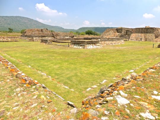

The west end of Casas Tapadas, viewed from the perimeter wall. The grassy area is one of the sunken patio spaces, with the Recinto in the middle. To its left is the #4 pyramid-temple and to the right is Casa de los Caracoles. This broad area would, no doubt, have been one of the main spaces for religious and political assemblies. 

Voladores (flying dancers) are believed to have performed here as part of religious rituals aimed at encouraging rain and fertility. The dancers spun through the air, hanging by their feet from ropes attached to a tall pole. Modern Voladores still perform these dances throughout Mexico, but the result hoped for today involves pesos from tourists rather than rain from Tlaloc.


The Recinto viewed from the platform's west entrance. To the right and left, you can see the staircases of the #1 and #4 pyramid-temples. Looming behind the Recinto is Casa de los Caracoles.  The Recinto is the first structure you encounter upon entering Casas Tapadas from the west. The other structures are clearly pyramid-temples used for religious purposes. In contrast, the purpose of the Recinto is unclear. 

The single-level platform is bounded on three sides by a low talud y tablera wall, but is open to the west. Small vestibules on either side of the entrance might have stored ritual materials. The Recinto does not appear to have had walls higher than what we see today. There is no evidence of columns or interior walls to support a roof. To me, the structure suggests an open-air meeting place. 

The participants would enter from the west side and sit facing each other along the walls of the other three sides. A council of priests, military leaders, and other elites may have assembled here to discuss weighty issues. It might also have served  as a reception space for visiting dignitaries.


Casa de los Caracoles from its northwest corner. This structure is at the center of Casas Tapadas and is the largest of the four pyramid-temples. The name Casa de los Caracoles (House of the Snails) comes from ornaments on the structure in the form of spiral figures resembling snails or conches. Such figures represent the cycle of life and fertility and are associated with Quetzalcoatl, the god who introduced humanity to maiz (corn). 

There is a small structure just left of the entrance stairs that may be part of an altar or perhaps a fragment of a wall that once encircled Casa de los Caracoles. Like the other pyramid-temples, this one has two stepped levels, with a partially destroyed temple on the second level. Leading into the west side of the structure is a stairway with two landings. The ruined temple has two rooms, one behind the other, connected by a central doorway.


Southeast corner Casa de los Caracoles, showing construction phases. This photo shows a common practice of pre-hispanic architects. Instead of demolishing a building and constructing another in its place, they simply covered over the previous building, using it as the base for the next one. This method saved a lot of time, labor, resources, and building materials. It also incorporated the spiritual power of the old structure into the new one.

Above, you can see that the pyramid-temple has had at least three incarnations. The oldest shows the talud y tablera style. It was covered by rubble which was then faced with smoothly cut stone. That version was later covered over with more rubble and smooth facing stones to create the final version. Rulers sometimes built a new temple over an old one to demonstrate their power, or to celebrate great victories or other significant events.


Rock carvings 

Some of many small rock pits and bowls carved into stone ridges. In some areas of the site, there are long ridges of rock that protrude through the grass. Carved along the tops of these are numerous pits and shallow bowls. The use and meaning of these features is not clear. At first, I thought they might be for grinding maiz. However, their sheer number and close proximity to one another suggest a ritual function. They are just another of Plazuelas' many mysteries. 


Lines of small holes have been pecked into this ridge. Again, the purpose is not clear, but a ritual function is suggested. One of the most unusual petroglyphs can be found near the Ball Court. It is a detailed scale model of Casas Tapadas, created by the original builders of the city. 

Archeologists found it very useful in understanding the ruins as they were digging them out and partially reconstructing them. In total, there are almost 1400 rock carvings found around the Plazuelas site. They include spirals, circles, lightning bolts, and zoomorphs. Some of them indicate influences from other regions of Mexico.

Tree ring dating shows that a great drought occurred in northern and central Mexico from 897-922 AD. This would have drastically affected the harvests of the Epi-Classic societies and seriously weakened them. It also meant that the parched deserts could no longer support a hunter-gatherer way of life. Thus began one of the great Chichimeca invasions, as the fierce nomadic tribes migrated en masse from the northern deserts and into central Mexico. 

This was the time period when Plazuelas met its fate, along with Xochicalco, Cacaxtla, La Quemada, and other Epi-Classic cities. All show signs of destruction and abandonment. In fact, the name La Quemada actually means The Burned Place. The Toltecs (900-1150 AD) were the next great empire. They may have been a melding of Chichimeca invaders and refugees from the Epi-Classic cities.

This concludes my posting on Plazuelas. I hope you found it interesting. If so, please leave any thoughts or questions in the Comments section below or email me directly. If you leave a question in the Comments section, please include your email address so that I can respond in a timely fashion.

Hasta luego, Jim


Thursday, August 19, 2021

Ameca Part 2 of 2: Parroquia Santiago Apostol, a 18th century jewel

Facade of Parroquia Santiago Apóstol, the main church. The Parroquia sits just north of the Plaza Principal. It faces the Mercado Municipal across Calle Fray Antonio de Cuellar, the andador (pedestrian-only street) that runs along the front of the church. Parroquia Santiago Apóstol is one of the most important churches in Valle de Ameca, both because of its long history and because of the pilgrims who come to view its 16th century statue, known as Señor Grande

This posting will focus on the Parroquia and its history, but also on the history of Ameca itself, which dates back 200 years prior to the Spanish Conquest. Thanks to our Tourist Police guide, Carole and I got to see parts of the church that foreign tourists ordinarily can't access. Here is a Google map, locating the Parroquia in Ameca.


The Exterior

The campanario, or bell tower, has three levels. There are spaces for at least sixteen bells on the first two levels. Beautiful tile designs cover the cupola atop the campanario. In addition to the main bell tower, there is a smaller one with a single bell over the church's main entrance.

Over the millennia, ancient Mesoamerica experienced a long series of migrations/invasions by tribes of nomadic hunters. The Aztecs called these fierce warriors Chichimecs. In fact, the Aztecs themselves had arrived as one of these groups in the 13th century AD. 

Chichamecs typically moved in and took over at times when great empires like Teotihuacán and the Toltecs fell. Amecatl ("String of Water") was founded by a Chichamec tribe speaking the Cazcan language. They arrived in 1325 AD and conquered the sedentary people then living in the Valley of Ameca.


The old bells of the campanario are attached to wooden headstocks. The headstock rotates on the metal crosspiece, causing the clapper of the bell to strike its interior surface. I am always charmed to find antique arrangements like this, still in use after centuries. The bells are rung in the old-fashioned way, with hand ropes.

The leader of the Cazcanes who founded Amecatl was called  Xoxouhqui Tequani ("Brave Lion") and was famed for his courage, ferocity, and cruelty. Soon, he came into conflict with the caltzoncin (ruler) of the Purépecha people. They had arrived in the area a year earlier than the Cazcanes and claimed sovereignty over Amecatl. The Purépecha were powerful, but the Cazcanes' bravery and battle prowess prevailed. Xoxouhqui Tequani's dynasty lasted for five generations.


The church dome is decorated with bright yellow tiles. The dome covers the area in front of the altar. Notice the old stonework on the side of the building. Most of the stones are in various sizes and shapes. The only "dressed" (square cut) stones are the ones forming the corners. This style prevailed when the cost of dressed stones was too great to allow their use to cover the full area of the walls.

The last Cazcan chief was Huitzil, the fifth generation descendant of Amecatl's founder. In 1522, the first Spanish conquistador arrived. He was a soldier named Juan de Añesta who was part of an expedition sent by Hernán Cortéz and led by Cristóbal de Olid and Gonzalo Sandoval

Juan de Añesta got separated from the expedition and when he appeared in Amecatl, he was alone, barefoot, and carried only his sword. Believing him to be a deity, the Huitzil and his subjects surrendered peacefully. 


Relief sculpture, dated 1749, of Santiago Mataindios. A mounted Santiago wields his sword over a decapitated head. During the 781-year struggle by Christians to drive the Muslim Moors out of Spain, Santiago Apóstol, (St. James the Apostle), metamorphosed into Santiago Matamoros (the Moor Slayer). 

The Reconquista (Re-conquest) finally culminated in 1492, just before Columbus sailed to the New World and claimed it for Spain. During the Conquest of Mexico, Santiago Matamoros was re-dubbed Mataindios (the Indian Slayer). The conquistadors considered him their Patron as they slaughtered their way across Mexico. 


The damaged statue stands in front of the Parrquia. I haven't been able to determine the identity of this figure and it may be a version of the Virgin Mary or a saint. The inscription under the statue only refers to the person who erected it. The damage may have occurred during an earthquake or possibly from vandalism during the 1926-29 Cristero War. 

Juan de Añesta lived in Ameca for several years after his dramatic arrival and the town became his encomienda.  This was sort of a legalized protection racket, originating during the Reconquista and imported to the New World to reward to soldiers for faithful service. 

The encomienda system gave a Spaniard the right to demand tribute, including free labor, from a designated group of indigenous people. In 1524, two years after Juan de Añesta arrived, Francisco Cortés, a relative of Hernán, stopped at Ameca to resupply his expedition.

The Nave

View of the nave from the choir loft in the rear. A service was under way at the time and this was the best way to get photos without disturbing the proceedings. A nave is the central chamber of a church, running lengthwise from the entrance to the altar. The name comes from the curved ceiling which looks like the hull of an overturned boat.

In 1529, a group of Franciscan friars arrived in Ameca. Soon they began construction of the first version of the Parroquia. It was a simple structure of adobe with a thatched roof. Their next task was to begin the evangelization of the natives. In their religious zeal, they smashed the natives' idols and overthrew their ancient religion. 

This same process happened throughout New Spain and, coupled with the inevitable abuses of the encomienda system, it led to deep discontent. In 1540, a great revolt broke out called the Mixtón War (1540-42).  It was centered in western Mexico, and a Franciscan friar from Ameca named Antonio de Cuellar was among the many who were killed. The andador along the front of the church was named for Fray Antonio


A gilded corinthian capital crowns a plain column along a side wall. The column was probably installed during the reconstruction of the church during the 18th century, when the prevailing style was Neo-Classic.

In 1567, a violent 7.2 earthquake shook the town, damaging many buildings, including the church. It is not clear whether the damaged structure was the original adobe church, or its first replacement, a three-nave church. 

The quake was centered in the base of the nearby Ameca mountains, according to contemporary Spanish accounts. The temblor caused a landslide which dammed the Rio Ameca until a breach could be made. Even then, the water smelled of sulphur and was unfit to consume for at least three months. 


The interior of the yellow dome shown previously. A large chandelier hangs from the center of the dome. Its interior is octagonal, with windows on each of the eight sides. The arches of the ceiling frame four of the sides. Where the arches meet are four triangular paintings depicting important saints. 

In 1570, two priests named Santiago Gómez and Pedro Bejarano  were assigned to direct the work of the parish. This probably included a considerable amount of reconstruction of church property after the recent quake. The two priests also commissioned the creation of Señor Grande (Great Lord), the statue of the crucifixion that still hangs in the central position of the altar's back wall.


A carved wooden pulpit wraps around the nave's corner. Like most colonial churches in Mexico, the floor plan of this one can be described as "cruciform" (in the form of a cross). The nave, running from the entrance to the back of the altar area, represents the main post of the cross. 

Just before the altar area, there are two open rooms extending to either side. Together, they represent the horizontal beam of the cross. The place where the main post and the crosspiece meet is covered by the central dome. The placement of the pulpit is at the entrance of the right side of the crosspiece. 

The Altar

The altar area is usually the most elaborately decorated part of a church. The columns surrounding Señor Grande are in the Neo-Classic style. On a bench in front of the altar are two rows of lit candles, left there by worshipers. Above Señor Grande is the Ojo de Providencia (Eye of Providence), surrounded by a sunburst. I will show this and explain its meaning in a bit.

Late in the 16th century, Fathers Santiago and Pedro ordered a statue of the crucifixion from a workshop in Pátzcuaro, Michoacan. Since pre-hispanic times, skilled Purépecha craftsmen had worked with corn paste and cornstalks to create lifelike statues. Local priests and friars began employing them to make Christian images, particularly of the crucifixion. These statues became popular for religious processions because the materials are very light and easy to carry. 


Señor Grande stands 2.1m (almost 7ft) tall and is somewhat gory. The image is quite lifelike and detailed. There is a great wound on one side and the body is covered with other wounds and streaks of blood. Such explicit and powerful imagery was very useful to the Church. Literacy was rare among the indigenous people, or even among the rank-and-file Spaniards. Visual images were necessary to generate the appropriate levels of religious awe. 

Señor Grande was crafted in a workshop owned by two brothers named Luis and Matías de la Cerda. Their fame spread widely after they produced the famous Virgen de Zapopan, housed in the Basilca of Zapopan, near Guadalajara. It has since become the focus of one of Mexico's largest pilgrimages. Orders began to pour in from all over New Spain. Among these was the one from Ameca's two priests. 

In 1600, Luis and Matías finished their work and sent the statue on its long 410km (255mi) trek to the north. The cost was 30 gold pesos or $7932 in today's US dollars (each colonial gold peso was 4.6 grams/22.5 carats). Costly, perhaps, but Señor Grande has lasted for 421 years. Legends associated with the statue began almost immediately after it began its long journey. 


The Eye of Providence gazes over the seats of the nave. Mounted just above Señor Grande, the Eye of Providence represents the all-seeing eye of God, looking benevolently over the world. The triangle surrounding it represents the Trinity. US citizens may recognize the Eye, because it appears on the back of the US paper dollar. Other countries also display the symbol on their national emblems, as do private organizations like the Freemasons and various other fraternal organizations.

The stories about how Señor Grande got to the Parroquia vary widely and most conflict with one another. One says the priests sent a commercial representative, who brought it back after an arduous journey during which he was beset by bandits. Another asserts that the statue arrived mysteriously in a wooden box left anonymously at the front door of the church in the middle of the night. 

Still others say the only part that arrived was the face and that the body was locally constructed. One account speaks of two mule drivers who found the full statue and its cross drifting down the Rio Ameca. Thinking at first that it was a human body, they swam out and rescued it. Not knowing what else to do, they left it at the Parroquia


A row of ornate candlesticks stands to one side of the altar. These appear to contain actual candles. In some churches I have visited, real candles have disappeared, replaced by simulations with small electric lights instead of flames. The reason, I have been told, is that the smoke from real candles causes damage to church paintings and statues.

Whether any parts of the stories of Señor Grande's epic trip are true, it did arrive in 1600 and was duly mounted on the wall of the altar. All these tales, as well as reports of later miracles, created a great deal of interest in the statue. Over the centuries. it has become the focus of pilgrimages from various parts of western Mexico and beyond. One pilgrim route comes all the way from Colima.

Images of Saints

Santiago Matamoros, dressed as a 16th century Spanish nobleman. He rides the great white horse on which he led Spanish Christians to victory over the Moors in the famous (and entirely mythical) Battle of Clavijo. Notice the two poles running along the base of the statue. When the Santiago Matamoros is taken out for religious processions through the streets of Ameca, members of the congregation use the poles to carry him on their shoulders. An example of this kind of procession can be seen in my photos of the Fiesta del Tastoanes.

In 1723, construction began on the current church, a project which wasn't completed until 1770. Such a lengthy process was not unusual in church building projects. Wars, famines, plagues, and simple lack of funds could interfere. The decision to build the Parroquia we see today was related to the insufficient size of the previous church, the one which had replaced the original adobe structure of 1529. The need was particularly pressing, given the swelling numbers of the faithful making the pilgrimage to see Señor Grande.


San Francisco de Assisi meditates while holding a skull. The skull is a reminder that we all must die someday. Franciscan friars from the Order he founded were the first evangelists in New Spain. A dozen of them, who became known as the Twelve Apostles of the New World, landed at Vera Cruz in 1524, barely three years after the fall of the Aztec Empire. Only five years after that, Franciscan friars arrived in Ameca and built its first church.

The Protestant Reformation of the 16th and 17th centuries ignited great religious turbulence, bloody wars, and the Inquisition. Catholicism needed a unifying figure and turned to San Francisco de Assisi (died in 1226 and canonized in 1228) because of his example of poverty and spiritual purity. 

He represented a return to first principles after the decadence and debauchery within the Church during the preceding Renaissance period. Thus, portraits and statues of San Francisco meditating over a skull abounded during the Reformation era, which coincided with the first two centuries after the Conquest of Mexico. 


San Jose Maria Robles Hurtado was martyred during the Cristero War. He was one of 25 priests killed in Mexico during that struggle who were canonized in 2000 by Pope John Paul II. Jose Maria Robles Hurtado (1888-1927) was fervent in his faith, perhaps even fanatical, and joined in the Catholic resistance to government policies of the post-revolutionary period. 

In the 1920s, the government under President Plutarco Calles began to enforce provisions of the 1917 Constitution, some of which severely restricted the power and prerogatives of the Church. This was not surprising, since the Church hierarchy had opposed the Revolution of 1910 and strongly supported the dictator Porfirio Diaz. In fact, the Church hierarchy had a history of supporting the rich against the poor and indigenous people, dating back to the earliest days of the Conquest.

In addition, the government was in the midst of land re-distribution, another key promise of the Revolution written into the new Constitution. The rich hacendados (hacienda owners) adamantly opposed this, although they and their ancestors had acquired their lands under highly questionable circumstances. The hacendados allied themselves with the reactionary Catholic movement known as the Cristeros. Their battle cry was Viva Cristo Rey ("Long live Christ the King"), and their war was called La Cristiada.

This collaboration sometimes resulted in the hacendados using Cristero units as death squads against the agraristas, who were farmworkers struggling to get land under the Constitution's redistribution provisions. The struggle over land was particularly intense in the area around Ameca, which saw the break-up of many haciendas. Robles Hurtado threw in his lot with the Cristeros, and supported the armed revolt. In 1927, he was arrested and hanged. 


Execution of a Cristero priest by a government firing squad. Although Robles Hurtado was hanged, along with many other Cristeros, some were shot. The priest in the photo was not identified.
 
Fearing complete destruction the the Church in Mexico, the Catholic hierarchy finally settled with the government in 1929, accepting restrictions on its religious activities. Some of these laws continued on the books until the 1990s. Even today, you can still see small signs on some Catholic churches declaring "Property of the Federal Government of Mexico."

This completes Part 2 of my two-part series on Ameca and I hope you enjoyed it. If so, please leave any thoughts or questions in the Comments section below, or email me directly. If you leave a question in the Comments section PLEASE include your email address so that I can respond.

Hasta luego, Jim


Tuesday, August 10, 2021

Ameca Part 1 of 2: A pretty colonial town in a lush valley


The Ameca's Plaza Principal is large, with extensive gardensThree sides of the Plaza are bordered by beautiful old buildings from the colonial era or the 19th century. I found Ameca's Centro (Center) to be the most attractive and interesting part. Full of old structures that are steeped in local history and culture, it is easy to walk around, while savoring the sights, sounds, and smells.

Small motorbikes like those in the foreground are popular in many Mexican towns. They are cheap, park easily, and use very little gasoline. The bikes often transport as many as four people, including mom, dad, and two kids.  The maneuvers they use while zipping through traffic are hair-raising. Carole and I first visited Ameca in 2013. Then, in 2015, I led a group tour which included an overnight stay in the city. The photos in this series are from both visits. 

Overview

Ameca is located west of Lago de Chapala and Guadalajara. From Ajijic, where I live, Ameca is about 1.5 hours drive. There are several routes you can take, but the shortest is west along the Lake's north shore to Jocotopec. Take the Jocotopec bypass to Highway 15, then head toward Guadalajara. When you get to the Guadalajara-Colima highway, turn toward Colima

Stay alert, because in less than a mile you exit that highway to the right at the sign for Highway 80 (Colima Libre) toward Barra de Navidad. Stay on Highway 80 and follow the signs to Villa Corona. About 13km (8mi) past Villa Corona, you come to a stoplight at Cofradia de la Luz

Take a right at the stoplight toward La Sauceda. Continue for 36.4km (22.6mi) to Highway 70, where you make a left toward Ameca, which is 22.7km (14mi) to the west. Once you reach Ameca, look for a large green sign that points to the right toward Ameca Centro.


View across Ameca toward Cerro de Águila. The English translation of Cerro de Águila is Eagle Mountain, but the original Nahuatl name is Cuahtepetl. The mountain is part of a range to the north of the city that separates Valle de Ameca from the valley containing the famous town of Tequila. 

The Ameca Valley is large and lush and consequently was settled by the Spanish early in the Conquest era. Prior to the Mexican Revolution, the Ameca Valley contained more than two dozen haciendas. They supplied grain, beef, horses, leather products and other goods to Guadalajara.

Ameca is the chief city of the municipio (equivalent to a US county) which surrounds it and shares its name. Municipio Ameca covers 685.7 square kilometers (426 sq.mi.) and has a population of over 57,000. The City of Ameca makes up about 36,000 of that total. 

The Rio Ameca runs through the southern portion of the city and is the source of the city's original name: Amecatl (Nahuatl for "string of water"). Ameca's economic base is still much the same as it was in the colonial era: ranching, agriculture and agriculture-related industries such as sugar refining. 


Meet one of Ameca's Tourist Police. He approached us as we walked about the Plaza and offered to be our guide. It was a great arrangement, because we saw a lot more than the ordinary tourist might. His uniform got us immediate access to all sorts of unusual places. 

Above, the door he has just opened leads into an ancient spiral staircase that takes you up to the Parroquia's roof and campanario (belltower). From there, we could closely inspect the old bells and enjoy a spectacular view of the city and the mountains around it. I took the photo of Cerro de Águila and several others in this posting from that point.


Plaza Principal

On the north side the Plaza are a series of arcades with arched portales. This is the oldest part of the city. If you could see inside the plaster of the internal walls, you would probably find some of the adobe from the 16th and 17th centuries. Like the pre-hispanic people, the Spanish did not tend to tear down old buildings. They just built over them, making modifications according to the styles of architecture prevailing at the time.

From colonial times into the 19th century, the ground floors of these buildings contained merchants' stores. In those days, they bought the grain and other products produced by the outlying haciendas and, in turn, sold them goods imported from Guadalajara, Mexico City, or Europe. The merchants and their families lived on the upper floors. Today those floors contain offices, apartments and a restaurant, while the arcade-level stores sell items like clothing, shoes, and ice cream.


View of the Plaza, looking east. Like most Mexican plazas, this one is clean, orderly, and lush with plants and trees. It reflects the pride that the local people take in their Centro. The kiosco has a rounded metal roof that looks a bit like a World War I army helmet. Most of the trees are carefully trimmed ficus a popular species for plazas. Ameca's Plaza is not bordered by streets full of cars. Instead,  andadores (pedestrian-only walkways) create a serene and leisurely atmosphere, free of exhaust fumes and auto frenzy. 


Another view of the Plaza's north side. Under its arcade, this building contains a pharmacy, a small grocery called an abarrote, and an ice cream store. Ice cream is incredibly popular in Mexico. Mexican towns, no matter how small, almost always have at least one place to buy ice cream on their plazas. Plaza de Ameca has several.

In the lower right, you can see a awning-covered vendor's cart selling small bags of snack food. To the left of the vendor's cart is a tricycle with a framework on the front for carrying cargo. These are very common throughout Mexico. Gasoline may be expensive, but the power from leg muscles isn't.


The west side of the Plaza is occupied by the Palacio Municipal. Also referred to as the Ayuntamiento, it is the seat of government of the municipio, a combination city hall and county seat. Above its entrance is a tall and very distinctive clock tower, visible from many points of the city. Cast iron benches line both sides of the walkway around the Plaza's gardens. Those situated in the shade of nearby trees are usually the first occupied on a hot afternoon.


Young students practice for Independencia. Mexico's annual Independence Day is celebrated on September 16. Almost everywhere, parades will march through towns. Student groups from every school will lead them, sometimes performing acrobatic stunts along the way. 

The parades will also include marching bands, floats, and groups of local charros on their beautifully groomed horses. Last year's Independencia activities were cancelled due to covid-19, and probably this year's too. However, we have managed to attend most of the celebrations during our fourteen years in Mexico. 

Palacio Municipal 

Carole and our guide stand in front of the Palacio Municipal. The original Palacio was built on this same spot in 1529, but burned in 1914. Although that year was one of the most intense periods of the Mexican Revolution (1910-1917), I have been unable to determine whether the burning was anything other than accidental. The magnificent Neo-Classic structure above was built between 1917 and 1924. 

Notice the bell hanging between the columns on the second level. Every year, on the evening of September 15, the municipal president will come out on the balcony, ring the bell, and give a speech to the crowd massed in the Plaza below. The same scenario occurs at the same time all over the nation, from the tiniest pueblo to the Capital of Mexico.

These events commemorate the original speech by Father Miguel Hidalgo when he rang the church bell at the pueblo of Dolores (today Dolores Hidalgo) to summon the residents. Hidalgo's famous grito (cry) against Spanish injustice launched the War of Independence (1810-1821). The ceremony with the bell is very moving and well worth attending if you are in Mexico at that time of year.


The ornate tower is crowned with battlements. There is a clock on each of its four faces. Our guide showed us through the whole building, including the office of the municipal president with its balcony and bell. He then indicated he had something special to show us and we walked up several flights of stairs. Carole, being the wiser of the two us, halted at the base of the tower. 

The guide and I began to climb up a tall rusty ladder, laced with cobwebs and covered with pigeon droppings. In a small compartment at the top, he proudly showed me the German-made internal mechanism of the clocks. He claimed it still worked perfectly after more than one hundred years of continuous operation. Sure enough, when I checked the clock against my watch, it was accurate to the minute. 


A student marching band takes break in the shade. Kids are always fun to photograph because they are so spontaneous and responsive. The three in the rear are waving to me with the two-fingered "peace sign". The woman in the doorway, probably their teacher, was keeping a close eye on the group. Not a bad idea, given the rambunctious potential of young boys of that age.


Mercado Municipal

Calle Juarez is an andador that runs along the west side of the Mercado. The Mercado Municipal (Municipal Market) is a long narrow structure that stretches for a block to the north from the Plaza. It is a semi-enclosed building with commercial stalls along each side. These booths sell fruits and vegetables, shoes, cowboy hats, leather goods, various crafts, and traditional foods. People of all ages come to browse. This makes the Mercado fun not only for shopping but for people watching.


Capilla de la Conchita was built in the 19th century. The small chapel faces the Mercado across Calle Juarez, about half way down its length. Despite its small size, the chapel contains an organ in its choir area. La Conchita (the Little Shell) is related to the Virgin of the Immaculate Conception and has been connected with miraculous occurrences all over Latin America. I took this shot from atop the Parroquia, which stands on the other side of the Mercado.


The east side of Mercado runs in front of the Parroquia. The arches of the beige building on the right are some of the stalls of the Mercado's east side. An andador called Calle Fray Antonio de Cuellar runs along this side of the Mercado. This shot was taken from the atrium in front of the Parroquia's main entrance. The view here is to the southwest, toward the Plaza and the Palacio.


Casa de Cultura and its Museo Regional

Fernando was our guide during my 2015 group trip. An intelligent and well-spoken young man, he worked hard to show us the best that Ameca had to offer. I found him through the municipio's tourist office. Almost every municipio has one of these offices and the staff are always very helpful. Usually, one of them will speak at least some English. Even if they don't, the staff will usually hustle around until they can find someone who can translate. 

The tourist offices can sometimes be a little hard to find, since they are often tucked away in obscure corners. However, you can usually locate them using Google maps, if you put in Oficina Turistica, with the name of the city you are visiting. When we visited Ameca, the office was inside the Palacio Municipal, but that was some years ago and the location may be different now.


The Casa de Cultura houses the Museo Regional. The museum contains a collection of more than 10,000 pre-hispanic artifacts. Most were donated by Profesor Filemón Gutiérrez Ramírez after he collected them over a 50 year period. The Casa de Cultura is located next to the Parroquia on Calle Gutiérrez

The hollow ceramic statue above is called a "Storyteller Figure". Many statues in this same posture have been found as offerings to the dead in tombs throughout Valle de Ameca. From their animated faces and hand gestures, archeologists believe they represent someone recounting myths or legends. I can imagine this occurring at night, around a roaring fire, accompanied by suitable oohs and aahs from the assembled crowd. 


Tiny pots, possibly used for paint or body oils. The paint may have been used for illustrations on walls or ceramics. Another possibility is male or female body decoration.  These were part of an array of pots and other ceramics displayed in the museum. Ceramic styles are among the most important clues archeologists use as they try to identify different cultures and the time frames in which they existed. Even fragments, called potsherds, can provide vital information. 

A critical element in an archeological investigation is context. This includes the level of the soil in which the object is found and its position in relations to other objects around it. When artifacts are looted from archeological sites, a tremendous amount of information is lost. After centuries of such looting, Mexico finally became aware of the need to preserve its heritage. To do this, institutions such as the Museo Regional were established.


A big-nosed figure sits in a posture of prayer. The ears are pierced and the hair is worn in a topknot. The figure's arms are crossed, in a stance that is associated with prayer. The sources of many of the artifacts are tumbas de tiro (shaft tombs). These were the burial sites of the Shaft Tomb Culture which occupied settlements in an arc from the coast of Colima, up through Jalisco, then back to the coast of Nayarit. 

They left few above-ground monuments, but their tombs were filled with wonderful statuary. This included people engaged in day-to-day activities, such as cooking, playing music, fondling children and pet dogs, dancing, and chatting with neighbors. Some of the pieces are detailed representations of the houses in which they lived. Many of the tombs have been looted and their contents sold to wealthy collectors. 

This concludes Part 1 of my two-part Ameca series. The next part will take a look at the Parroquia Santiago Apóstol and the history of the area. I hope you have enjoyed Part 1 and, if so, you will leave any thoughts and questions in the Comments section below or email me directly. Please include your email address with any questions so that I may respond.

Hasta luego, Jim