Tuesday, July 22, 2025

Valladolid Adventures Part 17: The ruins of the Franciscan Ex-Convento de Kikil


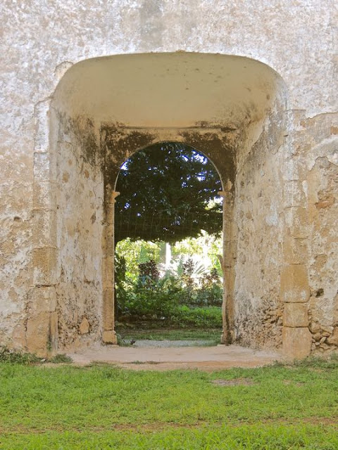
The front entrance of the Convento de Kikil's church, looking out. The thick walls and old wood rafters show the age of the Franciscan Convento's ruinsCarole and I discovered this place by accident, while returning from our visit to the north coast of Yucatan (see previous posting). As anyone who follows my blog knows, I am a sucker for old ruins and couldn't resist exploring this unexpected and mysterious site.

Convento de Kikil is not as large, nor is it as intact, as Convento de San Bernardino de Siena (see Parts 9-15 of this series). However, it is still impressive and worth a short stop to inspect it. The former cloister (see my next posting) is the most intact part of the site, but it was closed when we visited. I only discovered later that the cloister now contains a museum with artifacts from the Convento's history as well as some pre-hispanic objects. Consequently, I don't have any photos of the museum's contents.

Overview

Google map of the route. Proceed due north on Highway 295 from Valladolid to Kikil. The distance is about 58km (36mi). Highway 295 splits just north of Kikil, with the left fork going to San Felipe and the right to Rio Lagartos. The Convento's ruins are on the right side of the road, about 100m (100yds) before you reach the fork. According to a legend about the pueblo's name, it derives from k'i'ik', the Yucatec Mayan word for blood. The story, says that a priest was once beheaded in the nave of the church. It is also possible that the name comes from k'i'ik' che', the name of a local rubber tree.


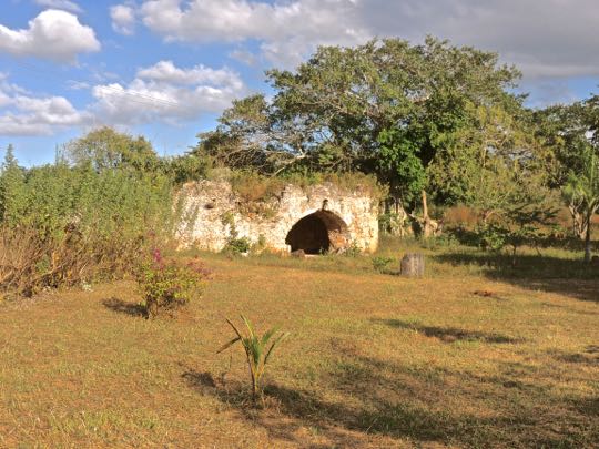
Convento de Kikil, as it appears from the road. The large rectangular structure on the right is Templo de Nuestra Señora de Candelaria and it was constructed in 1584. Another source calls it Templo San Román, but I find this name unlikely because San Román was martyred during the Cristero War (1926-29) long after the Convento was abandoned. In addition, some sources claim the Convento wasn't constructed until the middle of the 18th century. However the building style is much more like that of 16th century Franciscan structures.

The building is quite massive, measuring 65m (213.25 ft) long and 15m (49.2 ft) wide. Kikil's population is only about 200, and it was even tinier in the 16th century. To build such a large church, the Franciscan friars must have been very ambitious about their possibilities for evangelism. The cloister is the one-story structure on the left where the friars lived and worked. It was constructed in 1576, preceding the church by eight years. 


Google satellite view of the Convento. The Templo is the long structure (see the red marker) on the lower left, extending back from the parking area. The cloister is the light-colored structure extending at a right-angle from the Templo's other end. The exterior working area (shown in next posting) is behind the cloister to the right. At the far right is a low, circular stone structure that may be the remains of a noria (waterwheel). The area in the upper right is farmland that may have once been cultivated to support the friars and their Convento.


Templo de Nuestra Señora de Candelaria

The facade and front entrance of the Templo are rather plain. This is typical of colonial Mexico's 16th century Franciscan churches. It fitted the rather austere outlook and lifestyle of the Franciscan Order of that period. Above the arched entrance is the choir window. The long crack in the wall is probably from natural deterioration rather than earthquake damage. There is very little tectonic activity in northeastern Yucatan. The stonework at the top of the building's left corner differs from other parts of the facade, indicating a later addition. The most likely possibility is that it was once the base of a campanario (belltower). 


Two plain pilasters support the arch over the entrance. Unlike the rough stone used for the church's walls, the pilasters are of cut stone. This arrangement was typical of the late 16th century stone buildings that replaced the early adobe-and-thatch structures of the first part of the century. These pilasters are load-bearing, while others in the church pilasters are only decorative. Just inside the entrance are two niches which once contained statues of saints or other sacred figures.


Wooden rafters once supported the choir loft, just inside the entrance. The rafters show evidence of charring, indicating that the church was destroyed by fire, probably during the Caste War (1848-1915). That may also have been the occasion when the priest was beheaded. Despite the fire damage, you can still see the carefully carved undersides of the rafters. Decorative details like this can often be found in colonial religious structures, even in areas of a structure that are hard to see with the naked eye. The roof line has developed quite a lot of vegetation, adding to the overall sense of antiquity.


Looking down the length of the nave toward where the apse used to be. The apse is the curved end of a nave where the main alter is located. All that remains here is just open space. There are four empty niches visible, two on either wall. They are separated by two doorways, one either side of the mid-section of the church. The floor, which was once tiled, is now covered by grass and weeds. Much of the original lime plaster still covers the walls.


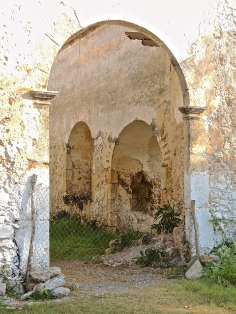
Detail of one of the nave's niches and a pilaster. The niche was probably filled with one of the many Franciscan saints, perhaps one who was martyred. It could even have contained a statue of San Francisco (St. Francis) himself. Although plain in design, the pilaster is carefully carved, unlike the rough stones in the walls. As with many pilasters, it does not support any weight, but is just a decorative element. 


View from the apse area back toward the entrance and choir window. The roof apparently collapsed during a hurricane in 1920. Efforts to prevent further deterioration began in 2020. Plans for renovation of the decayed structure have been submitted by a committee of local citizens. However, the federal Maya Train Project put things on hold and there is a dispute between the local committee and the National Institute of Anthropology and History (INAH) over the Convento's ownership. Over time, looters have dug holes in the walls, while others were dug to loot valuables from the graves in the floor of the nave.


One of the two side doors of the nave. Thick walls were necessary because outside buttresses were not used for support. The walls' rough limestone chunks were held in place with mortar made from sascab and honey. Sascab is a powder from decayed limestone that was widely used for mortar from pre-hispanic times through the colonial era. Quarried limestone was sometimes crushed and burned, along with animal bones, to create mortar. However, when it was available, sascab was the preferred material. It didn't require burning and the consequent necessity of large scale woodcutting to feed the fires.

This completes Part 17 of my Valladolid Adventures series. In Part 18, I will show you the cloister and some of the Convento de Kikil's external features, including its work areas. I hope you have enjoyed this posting. If so, please leave any thoughts or questions in the Comments section below or email me directly. If you leave a question, please include your email so that I may respond in a timely manner.

Hasta luego, Jim


Saturday, July 5, 2025

Valladolid Adventures Part 16: A day-trip to Yucatan's north coast

Homenaje al Pescador ("Homage to the Fisherman"). This statue on the malecón celebrates San Felipe's long history as a fishing port on Yucatan's north coast. The blowing palms show the strong, chilly wind off the ocean that was blowing. During the winter months, when we visited, Yucatan's coastal areas can be surprisingly cool and breezy. San Felipe's population is 1,838, but the town looked bigger when we drove into it. It sits at the mouth of an estuary that is part of the Rio Lagartos Biosphere Reserve, which has concentrations of pink flamingos similar to those at Celestún, on Yucatan's west coast.

We went on this adventure to see what  the area to the north of Valladolid had to offer. In this posting, I'll show a bit of San Felipe and its malecón (waterfront) lined with fishing boats. During our drive back to Valladolid, we briefly visited the small city of Timizin, with its historic Parroquia de los Tres Reyes (Church of the Three Kings). Near Tizimin, we also discovered and explored the ruins of the Franciscan Ex-Convento de Kikil.  However, that will be covered in the following two postings.

Overview

Google satellite map of northern Yucatan showing our route. We took Highway 295, a libre (free) road that proceeds due north from Valladolid. At Kikil, a short distance north of Timizin, the road splits, with the right fork going to Rio Lagartos and the left going to San Felipe. The two pueblos are about 11km (6.8mi) apart along the north coast. When you reach San Felipe, stay on the same road all the way to the malecón. The length of the trip (one way) is 107km (66.5mi) and it takes a little less than two hours. The country you pass through is flat and covered with farmland and forests. Traffic was light during our drive. 

The fishing port of San Felipe

The pier near the statue has a palm-frond palapa at its end. I was impressed by the town's general sense of prosperity. All of the boats I saw looked in good condition, with large, powerful motors mounted on their sterns. Everything, including the boats and the town itself, seemed clean and well-kept. Notice the land that lines the horizon in the background. This is part of a long, narrow east-to-west spit of land that forms the northern part of the bay and protects both San Felipe and Rio Lagartos from the open ocean beyond. The land spit is part of the Biosphere Reserve. 


View from the pier's palapa back toward the malecón. The palm fronds show the powerful winds that buffeted us. Restaurants, stores, and hotels line the shore along the malecón. Many of San Felipe's homes and other structures were originally built with varnished cedar which could resist the moist salt air. However, they couldn't withstand the force of Hurricane Gilbert in 1988, which destroyed a lot of them. It was apparently so powerful that even the protection of the land spit didn't save them.


Looking west along the palm-lined malecón. Each of these boats has its own name. The one in the foreground is called "Aremy K". Notice the horizon in the upper right. That is the mouth of the bay and beyond is the Gulf of Mexico (NOT "America"). The shore of what is now San Felipe was first visited 200 years ago by Maya fishermen from Santa Clara or Dzilam Bravo. According to legend, they sought shelter during bad weather. Looking for fresh water, they followed the sound of the native Chuleb birds and found a spring which they called Akta Chuleb ("Ahead of Chuleb").


The view toward the east shows more boats and piers. Although the wind was chilly, the day was sparkling clear, and sunny. Above-ground water is scarce in Yucatan, but with the discovery of the Akta Chuleb spring, it became possible to establish a temporary fishing camp. As more and more Maya visited, they discovered good land for farming and hunting. Some brought their families and settled permanently. At an unknown time, Akta Chuleb was given the new name of San Felipe, to honor the Franciscan martyr San Felipe de Jesus. My bet is that it happened when the the first friars arrived, because that was their usual practice. 


Restaurant El Popular Vaselina is located where the pier meets the malecón. The restaurant is covered by a thatched palapa and its sign has lobsters on either end dressed as waiters. Not surprisingly, its specialty is seafood.  San Felipe has many good restaurants and several inexpensive hotels along its waterfront. Although we didn't stay long, (Carole doesn't care for windy places) the town has plenty to do. In addition to strolling along the malecón waterfront, boats can be hired to fish or to visit the Biosphere Reserve and an archeological site. San Felipe has a very laid-back atmosphere. Hopefully, it is not yet overrun by tourists.

Tizamin de los Reyes

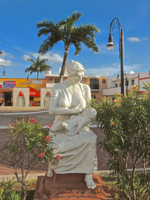
A statue commemorating motherhood shows seated woman nursing her baby. The subject of motherhood is popular in Mexiccan art. I have seen other statues glorifying it in places like Mérida, Yucatan's capital. The statue stands on the perimieter of Parque Principal Francisco Cantón, the main plaza of the city of Tizimin. In the local Maya dialect, the name of the city means "Place of the Tapir". It is located 52km (32mi) north of Valladolid on Highway 295, about half-way between that city and the north coast. With a population of 47,000, Tizimin is the second largest city in eastern Yucatan, after Valladolid. 


Parque Principal Francisco Cantón and its central kiosco. It is a very neat and well-kept plaza with many benches for those wishing to while away a sunny afternoon. All the buildings around the plaza are freshly painted in a variety of pastels. Francisco Cantón (1833-1917) joined the military at age 16 to fight the Maya during the Caste War (1848-1915). He later supported the rule of the French-imposed Emperior Maximillian (1862-1867). However, after the war, he reconciled with the Liberal Party under Porfirio Diaz and served as Governor of Yucatan from 1898 to 1902. 


Parroquia de los Tres Reyes stands across from the plaza's east side. The Church of the Three Kings is named after the three magi who, according to the New Testament, were guided by a star to visit Bethlehem and bring gifts to the Baby Jesus. The church was built in the 17th century, but the Franciscans had been evangelizing in the area since the middle of the 16th. In fact, Valladolid was originally founded in 1543 in the Tizimin municipality (equivalent to a US county). The new city was moved to its present location two years later because the first site was too swampy and unhealthy.


Melchior, one of the Three Kings, standing in a glass case in the church. The other two, Gaspar and Balthazar, stand nearby. A 16th century Franciscan friar named Andrés de Avendaño was inspired to use the Three Kings as an evangelizing tool at Tizimin. The three most important local gods were Yum Chac (Lord of the Rain), Yum Kaax (Lord of the Field), and Yum Ik (Lord of the Air). The Franciscan friar simply worked to substitute the Three Kings for the trio of Maya gods. This was similar to the tactic used by missionaries who created the Christmas tree to capitalize on the pagan German worship of the fir tree. 


This magnificent retablo stands in the apse at the end of the nave. The carved wood structure has thirteen niches for statues and paintings of various saints and sacred scenes. The retablo is in the Mexican Baroque style and includes sixteen spiraling Solomonic columns. Tizimin's Parroquia de los Tres Reyes is the second most important shrine to the Three Kings in the world, after the one in Cologne, Germany. The annual fiesta on January 6 draws thousands of participants. It includes a parade in which the Three Kings are paraded through the town. A similar fiesta is held the same day in a pueblo near Ajijic, where I live.


A sliver reliquary is bracketed by 12 silver candlesticks. Reliquaries are used to contain sacred relics. The number of candlesticks suggests that they represent the Twelve Apostles. Usually, reliquaries are in the shape of a box with a door in the front. This exquisitely decorated version is shaped like a coffee can, with a dome on top. Often, reliquaries are guarded by a brace of angel statues, but there were none in evidence here. There was also no indication of the nature of the relics contained in this reliquary.


A hexagonal pulpit is mounted on a side wall of the nave. I was impressed by the beautifully painted relief carvings of sacred figures on each of its six sides. The term pulpit comes from the Latin "pulpitum". The use of raised platforms dates back to ancient Israelite worship and Greek and Roman speaking traditions. They were first mentioned in regard to Christian practices by Cyprian of Carthage in the 3rd century AD. By the Middle Ages, they had become prominent features in churches. While pulpits in Catholic churches are often found on a side wall, in Protestant churches they are usually in the front.


A niche along the nave's wall contains a statue of the Virgen de Guadalupe. I immediately thought of her when I saw this statue. However, upon closer inspection, I had doubts. Many of the attributes of the Virgen de Guadalupe are present, including the sunburst halo that surrounds her and the type of clothing she wears. However, although I have taken hundreds of photos of her images all over Mexico, until Tizimin I had never encountered one in which she holds a child. After I Googled up numerous images of her holding the Baby Jesus, I was able to confirm my original opinion. Live and learn!

This completes Part 16 of my Valladolid Adventures series. I hope you have enjoyed it. If so, please leave any thoughts or questions in the Comments section below or email me directly. If you leave a question, please include your email address so that I can respond in a timely fashion.

Hasta luego, Jim