Friday, February 28, 2025

Valladolid Adventures Part 3: Fiesta in the Parque Principal


Dancers with tambourines entertain the crowd at a  fiesta. We wandered through Valladolid's Parque Principal one day and found ourselves engulfed by a large, colorful celebration. We were somewhat mystified by what it was all about, since there were no fiestas or holidays listed on our calendar for that day. I was so absorbed in my photography that I forgot to ask. However, everyone was cheerful and friendly and it was lots of fun. 


View over the Parque's fence. As we approached the Parque, itt was apparent that something was happening. There were lots more people than usual and the walkways were lined with booths selling handicrafts and food. The rickshaw-style vehicle just over the fence is one way that people with limited mobility (or who are just tired) can enjoy the sights here.


People waving a variety of flags lined both sides of the walkway. Other than the Mexican national flag, I didn't recognize the others. I thought at the time that they might be the flags of Mexican states. However, when I downloaded the photos to my computer, I began to notice that they were the national flags of various countries. The flag in the right foreground appears from the Caribbean island nation of Trinidad and Tobago. I believe the next two on the right are from Palestine and Ukraine.


This participant is brandishing the national flag of Spain. I was able to identify it by closely studying the emblem in the middle. After examining several of the flags, I now think that the fiesta had something to do with international friendship. However, when I googled the United Nations website listing international celebrations, there is nothing listed for January 15, the day of the fiesta. So. the mystery continues.


Singers belt out a tune in Spanish as a participant waves the Mexican flag. Although we didn't understand the words, the singers were energetic, the tune was catchy, and the crowd was really excited.


Several people blew animal horns as the tambourine girls danced. The flag in the upper left corner of the photo is that of the South American nation of Colombia. The whole fiesta was very colorful, if somewhat bizarre. But then, that's the way I experience most of Mexico. Upon further reflection, I suppose a lot of U.S. celebrations could rightly be called "bizarre."


The tambourine girls dance sedately while waving yellow cloths in time to the music. Dance performances of various kinds are a popular feature of Mexican fiestas. Often they have pre-hispanic themes, but the girls' costumes seemed to reflect a classical Greco-Roman theme. Along the walkway in the distance, still more flags flutter. 


The crowd cheered lustily and waved their arms in appreciation of the performances. Everyone, including Carole and I, was having a great time. Still, we had no idea--and still don't--what it was all about. You never know what's around the next corner when you live in Mexico. But that's the fun of it!

This completes Part 3 of my Valladolid Adventures series. I hope you enjoyed it. If so, please leave any thoughts or questions in the Comments section below. If you leave a question, please include your email address so that I can respond in a timely way.

Hasta luego, Jim


Thursday, February 20, 2025

Valladolid Adventures Part 2: Parque Principal, the center of the city's life


A young Yucateca studies her smartphone at the west entrance to the Parque Principal. Like the rest of the world, Mexicans are addicted to their smartphones. From very young children to the elderly, and all between, everyone seems to own one. They either stare into it intently, or walk along with it pressed to an ear. In either case, they tend to be oblivious to anything else, including other pedestrians or on-coming traffic, sometimes with unfortunate results. I was able to snap the photo above from a relatively short distance without any apparent awareness on the part of of my subject.

In this posting, I'll walk you through the Parque Principal so you can see some of the people and the typical activities that occur here. Because I got so many great shots here during our stay, I have created three separate postings. The first will be about the Parque itself. The next will show a fiesta that happened there during our visit. The third focuses on the beautiful handicrafts that were sold during the fiesta. 

Overview

Google satellite view of the Parque Principal. The top of the photo is north. Our hotel, El Mesón de Marques, is on the north side of Highway 180 (one-way heading west) and looks south over the Parque across the street. Just west of the hotel is Centro Artesenal Zaci, the handicrafts center. The east side of the Parque is bordered by Highway 295 (one-way heading north). From north to south along this street are the Correos de Mexico (Post Office), the Casa de la Cultura (House of Culture), the Ayuntamiento (City Hall) and the Oficina de Turismo (Tourist Office). 

The street along the south side of the Parque is Highway 180 (one-way heading east), which contains some restaurants on the eastern half of the block and Templo San Servacio on the west end. The west side of the Parque is bordered by Highway 295 (one way heading south). Facing the Parque along this side is an attractive arcade with arched portales, under which are a series of commercial establishments. In the center of the Parque is the fountain with the statue of La Mestiza that you saw in Part 1 of this series.

If you take Highway 295 north, you can access the ancient Maya ruins of Ek Balam and ultimately the small, scenic port of San Felipe on Yucatan's north coast. Heading west on Highway 180 will take you to the famous ruin of Chichen Itza. Going east on 180, you will pass by another ancient city called Cobá and finally reach the coast at Tulum, where there is yet another famous Maya ruin. Heading south on 295 takes you into the interior of the Yucatan Peninsula, where there are additional Maya ruins and other historical sites. From these descriptions, you can understand the centrality of the Parque and of Valladolid itself.


Parque Principal Francisco Cantón Robles

View from the west entrance toward the fountain. Behind the trees in the background are the Ayuntamiento and Casa de Cultura. Those who built the Parque were very generous in their placement of benches and shady trees. The people who enjoy the area use it to relax, play, and to meet old friends or encounter new ones. The general atmosphere is laid-back and genial.  

The Spanish city of Valladolid was originally founded in 1543. Two years later, in 1545, it was moved about 50k (31mi) south to the Maya city of Zaci, its present location, which was re-named ValladolidThe move was opposed by the founder, Francisco Montejo el Sobrino, but the original place had been humid and full of mosquitos and many of the Spanish settlers had sickened and died. Almost no one but el Sobrino wanted to stay at the old location and he was forced to give in. From Zaci's original population of about 1000 Maya natives, the city has grown to about 56,500 today.


At the center of the Parque is the fountain with the statue called La Mestiza. The emblems on the tops of the white benches are Valladolid's coat-of-arms. For the story of La Mestiza, see Part 1 of this series. The area comprising the Parque originally contained Zaci's large pyramid, a structure that was 100 meters square at its base. The Spanish demolished the pyramid and used the materials to construct many of the present-day structures facing the Parque across the surrounding streets. 

It was typical Spanish practice to tear down temples and pyramids in places they settled. Sometimes this was done to obtain building materials for their mansions, churches and public buildings, but it was also intended to make an ideological statement. They considered the religious beliefs of the indigenous people to be "devil worship" and were determined to supplant them with Catholicism. When pyramids were too large to destroy, they would often build a church on the very top to make clear who was now in charge.


A recent rain squall had left the Parque's walkway glistening. Yucatan is surrounded on three sides by the Gulf of Mexico, the Caribbean Sea, and the body of water to the north where they meet. Weather is thus very changeable. This photo shows the western border of the Parque. The building on the right is the Ayuntamiento. The building on its left, with the arched portales on both floors, is the Casa de Cultura

The Spanish conquest of Yucatan was a slow process. The first contact occurred during Christopher Columbus's fourth expedition to the New World in 1502. However, the last independent Maya city-state of Tayasal was not conquered until 1695, almost 200 years later. Over the 25 years following 1502, the Spanish conducted a number of brief visits and small explorations into Yucatan. These were mostly stops by ships to refresh food and water supplies, look for gold, or to capture slaves. With only a few exceptions, these intrusions were met with fierce Maya resistance, resulting in many Spanish casualties. 


A small boy is fascinated by a large bubble floating through the air. When I took this shot, a mother behind me was blowing bubbles to entertain her child. One of these floated through the middle of the photo I was taking. I didn't realize the interesting image I had captured until later, when I downloaded the photo onto my computer. This is typical of the quirky nature of Mexican plazas.

One of the conquistadors who participated in the early explorations was Francisco Montejo. He had been the captain of one of the Spanish ships in the 1518 Juan de Grijalva expedition. He was also the uncle of Francisco Montejo el Sobrino (the Nephew), who later founded Valladolid. In addition Francisco Montejo had a son named Francisco Montejo nicknamed el Mozo (the Younger). The son participated in the conquest of Yucatan and founded Campeche, the first permanent Spanish town on the Peninsula. In order to avoid confusion I'll refer to the son and nephew as el Mozo, and el Sobrino.


Templo San Servacio stands across from the southwest corner of the Parque. The Spanish began constructing the original church with materials looted from the pyramid shortly after el Sobrino moved Valladolid's location to Zaci. However, that church was demolished in 1705 by order of the Bishop because of a crime that was committed within it. Construction of the church you see above began that same year. I'll go into the details of all this when I do my posting on Templo San Servacio.

In 1527, Spanish King Philip II gave Francisco Montejo the right to conquer Yucatan. He immediately set to work. However, the conquest of the Maya proved a much more difficult task than Hernán Cortez had with the Aztecs. This is interesting because the Aztec empire was large, unified, and could field well-trained armies of considerable size. Cortéz  conquered the Aztec empire by seizing its ruler in what amounted to a coup d'etat Franciso Pizarro later used the same strategy to conquer the Inca empire. Fierce fighting lasted for a few years after both coups, but the conquests were over relatively quickly. 


A man chats with a woman and her son as they bask in the winter sunshine. In the upper left, a trio of young people hang out on another bench. The scene above is typical of what you find in the Parque, or in any one of the innumerable other plazas in Mexico's towns and cities. This is a culture that, for the most part, still moves at a relaxed and leisurely pace.

The difference between the conquest of the Maya and that of the Aztec and Inca empires lies in the dispersed nature of power among the Maya, as well as in the much more difficult climate and terrain. During pre-hispanic times, there had never been a Maya empire and when the Spanish arrived, there still wasn't. The Maya of Yucatan were separated into as many as 24 different kuchkabaloob (city-states). Each city-state had to be individually conquered, and they had a bad habit of not staying conquered. Sometimes, when a town was captured, its inhabitants would just flee into the thick jungle until the Spanish left.


Strollers pass along the sidewalk of a street on the west side of the Parque. This is the side with most of the commercial establishments. The arched portales of the building above support an open-air arcade lined with numerous small businesses. The balconies along the second floor have French doors which open into offices, or possibly apartments. If you continue south on this street, you will exit the city and pass into the vast interior of the Yucatan Peninsula.

In 1540, after thirteen years of effort, Francisco Montejo turned over his right of conquest to el Mozo. The son, along with his cousin el Sobrino, energetically continued the work. The same year his father retired, el Mozo founded Campeche on the Gulf coast. He then sent his cousin north where el Sobrino defeated the Maya at the city of T'ho. In 1542, el Sobrino founded Mérida at T'ho, building the new city with materials from the temples of the old one. In 1543, el Sobrino was sent east where he conquered Zaci and founded Valladolid. Thus, within three years, Yucatan's three most important colonial cities were established.


Two Yucatecas chat on sillas tú y yo, a form of seating that may be unique to Yucatan. Sillas tú y yo ("you and me seats") are a fun and comfortable way to interact with another person. In our travels around Mexico, I can only recall seeing them in Valladolid and Mérida. Many of the older generation of Yucatecas still wear the traditional, beautifully-embroidered huipiles (sometimes spelled hipiles) on a day-to-day basis. However, most of the younger ones seem to have adopted north-of-the-border styles like shorts and t-shirts.

Even after the three colonial cities were founded, the Yucatan Peninsula's Maya people remained defiant. In spite of savage reprisals, there were repeated revolts throughout the following centuries. A couple of times, the Spanish (and later the non-Maya Mexicans) were almost driven out of the Peninsula, The greatest revolt of all was the Caste War (1847-1933). The Zapatista uprising of 1994 was the most recent echo of this centuries-long struggle. 

This completes Part 2 of my Valladolid Adventures series. I hope you enjoyed it. If so, please leave any thoughts or questions in the Comments section below or email me directly. If you leave a question, please include your email address so that I can respond in a timely manner.

Hasta luego, Jim


Thursday, February 13, 2025

Valladolid Adventures Part 1: A jewel among Yucatan's treasures

Statue on the central fountain of Parque Principal Francisco Cantón Rosado. She is called "La Mestiza" (meaning mixed Spanish and Maya) and wears an embroidered huipil, the traditional garb women in Yucatan. Manuel Cachón sculpted the statue in 1924. His original work was replaced for a time by a monument to the heroes of June 4, 1910, who ignited the Mexican Revolution. Eventually, that monument was itself replaced by this replica of the original. La Mestiza's smile epitomizes the friendly, laid-back local attitude.

In Part 1 of my Valladolid Adventures series, I will do something a little different from my past practices. I intend to briefly highlight some--but not all by far--of the fascinating things to see and do in this small city in central Yucatan. Each of these places will be covered in some depth in future parts of the series. My future postings will also cover nearby places we visited on day-trips outside Valladolid. These will include Maya sites like Ek Balam, Cobá, and Muyil, and the great colonial-era monastery at Izamal. If the Yucatan Peninsula is a treasure chest of experiences, Valladolid shines as one of the brightest jewels.

Overview

Google map of our route from Mérida to Valladolid. In January of 2017, we flew into Mérida from Guadalajara, and rented a car at the airport. We stayed the night at a nearby hotel so we would be fresh for our drive the next morning. It is a pretty straight-forward route. You head south on the highway from the airport and look for signs for the Mérida Periferico and Cancun. Once on the Periferico, you travel for 19 km (11.8 mi) or 20 minutes. Turn right at the exit for Cancun, onto the autopista Highway 180. (Alternatively, you could fly into Cancun and drive from there to Valladolid, about the same distance.)

The Highway 180 autopista (high-speed toll road) should be in excellent condition. Follow 180 for about 2 hours until you come to the exit on the right for Valladolid. From the exit, drive 5.6 km (3.5 mi) south along Highway 295 to Parque Principal in the center of the city. We stayed at Hotel Mesón Marquis, which faces the Parque's north side. There are other good hotels in Valladolid, but we chose this one because it was central and within walking distance of nearly everything we wanted to see. For a Google interactive map, click here.

Parque Principal Francisco Cantón Rosado

The fountain of La Mestiza is surrounded by a circle of benches. Walkways radiate out from the path around the circle. Through the trees on the south side of the Parque, you can see the bell towers of Templo San Servacio, Valladolid's main church. Although the Parque is generally fairly serene, there was a colorful fiesta during part of our visit, with booths selling a variety of handicrafts. In the next posting of this series, I will give you a taste of this vibrant event.

The Parque Principal stands in an area once covered by a Maya pyramid that was 100 m2 (109.3 yds2). Following the usual Spanish practice, the pyramid was demolished and its materials were used to build the City Hall, mansions for the conquistadors, and an earlier version of the Templo San Servacio, . The space left by the removal of the pyramid became Plaza de Armas, so-named because that was where the colonial militia met to drill. In 1900, the plaza became Parque Principal Francisco Cantón Rosado, named for the Governor of Yucatan who donated the fences surrounding the Parque

Templo San Servacio

The church resembles a fortress because it occasionally functioned as one. Notice the high walls and three vertical gun slits on each tower, placed there to be used during periodic Maya revolts. Since the Maya refused to stay conquered, the Spanish buildings had to be defensible. As mentioned above, the original church was built from materials looted from the pyramid of Zaci. That was the name of the people living in the area when the Spanish arrived. After the conquistador Francisco de Montejo el Sobrino defeated them, he named his new city Valladolid, which was the name of the city that was then capital of Spain. 

As I mentioned, the church above is not the original Templo San Servacio. That structure was demolished in 1705 on the order of the bishop, Don Pedro de los Rios Reyes, "to help erase the stain" of a crime that had been committed on its premises. In a future posting, I will detail how it was that the church came to be rebuilt in its present form. Visitors to my blog may have noticed that I spend a lot of time photographing and talking about religious structures like this one. I am not a religious person myself, but I do admire the artistry and cultural significance of Mexico's colonial heritage, as well as its pre-hispanic heritage. 

Hotel Mesón de Marques

Courtyard and swimming pool of our hotel. I took this shot from the balcony just outside of our room. This hotel was one of the nicest we have stayed at during our time in Mexico. The location of the hotel was ideal for exploring the city on foot. The staff were friendly, efficient, and helpful. One of the best aspects was the restaurant, located around another courtyard, where we ate most of our breakfasts and dinners. The food was delicious, reasonably priced, and the service was excellent. A future posting will cover this very special hotel.

The Méson de Marques (Mansion of the Marquis), was built in the 17th century for a high-level member of the Spanish aristocracy. In colonial times, the most important members of the local community built their homes facing the main plaza of a city, or along streets adjacent to it. The further out you lived, the lower your social status. The indigenous people lived on the outskirts and provided the cooks, maids, gardeners, and other servants of the wealthier classes. All this didn't happen by accident. It was the result of deliberate colonial urban planning dictated by Spanish King Phillip II in the last part of the 16th century. 

Ex-Convento San Bernardino de Siena de Sisal

View of the Ex-Convento from the right. The distant figure in the center is Carole. Construction on this Franciscan ex-convento (now a museum) began in 1552 and was completed in 1560. That's quite a rapid pace for such a large structure. In fact, it is the second largest Franciscan construction in Yucatan, covering 14,121 sq meters (15,442 sq yds). Included in the complex are the church, cloister, chapel, and orchard. The ornate retablo behind the church's main altar is particularly notable. Given the size of the complex, I will probably do more than one posting on it later in this series.

For those who viewed my recent series on the Franciscan convents in the Sierra Gorda, you will recall that the Franciscans played a major role in Mexico during the so-called "Spiritual Conquest". Some of the young Franciscans who worked in the Sierra Gorda ended up in leadership positions in the Yucatan missions later in their lives. That the Yucatan's two largest conventos were both Franciscan shows the significance of the Order's role here. Ex-Convento San Bernardino de Siena is located about 7 blocks southwest of the Parque.

Cenote Zaci

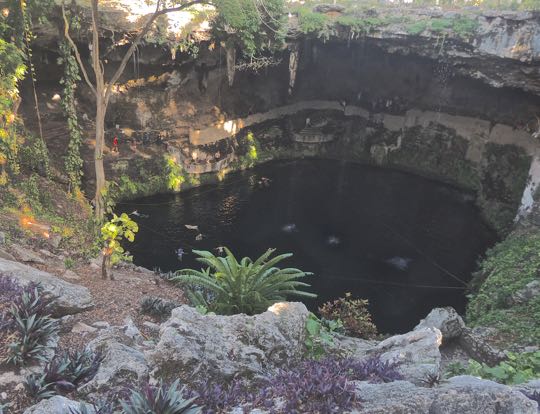
Cenote Zaci is a deep, shady, water-filled pit in the limestone crust of Yucatan. The small floating objects in the water are swimmers. The figure dressed in red by the tree on the left provides a sense of scale. Cenote Zaci is open from 8:30am to 5:30pm with a modest entrance fee of 30 pesos ($1.50 USD). There are changing rooms and restrooms as well as an adjacent restaurant. Lifejackets are also available. Only a few of Yucatan's cenotes are located so conveniently within a town. This one is just 4 blocks northwest of the Parque Principal

Cenotes are found throughout northern Yucatan and were the main water source for the ancient Maya civilizations that developed here. Including Cenote Zaci, Valladolid has at least two cenotes within blocks of where the Zaci pyramid once stood. Most of Yucatan is a flat, porous limestone shelf. Rainwater seeps down into it to form underground pools. The crust over some of these pools eventually erodes and collapses, leaving an open pool. The meteor that struck the coast of Yucatan 60 million years ago not only killed all the dinosaurs but created a series of concentric cracks in the limestone which helped create the cenotes.


Museo Regional San Roques

Ancient Maya stucco mask. The facial features include a rounded, chubby face, thick lips and a flattened nose. These give the mask an uncanny resemblance to those on the great stone Olmec heads found in the State of Veracruz. The Olmec heads were found hundreds of miles away from Valladolid, and their civilization died out at least 1000 years before this mask was made. I therefore found the resemblance very odd. I would be open to hearing from anyone who can enlighten me about this. The mask, along with other Maya artifacts, are displayed in the Museo Regional San Roque, about 1 block east of the Parque Principal. 

The site of the museum has a long and colorful history. It was originally a 4-bed hospital, founded as Hospital del Santo Nombre de Jesus in 1575 by Valladolid Mayor Don Diego Sarmiento de Figueroa. This evolved into the Convento de San Roque and by 1645 the hospital was the best in the province. All this has long since disappeared except for the temple to San Roque. Several historical figures are buried under the museum's courtyard, including those killed in the crime that resulted in the demolishment of the Temple of San Servacio, as well as activists executed at the beginning of the Mexican Revolution.

Iglesia Santa Ana

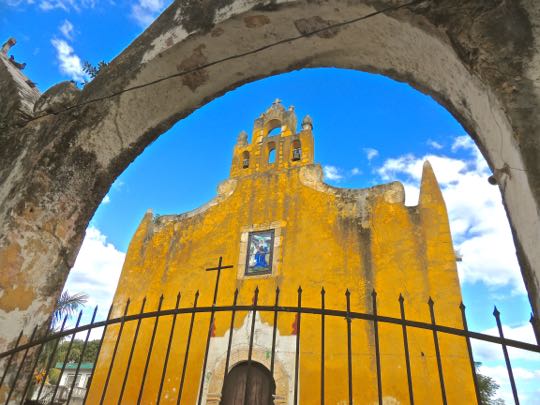
Iglesia de Santa Ana, seen through one of the triple arches of its front gate. This small 16th century church was originally built for the Maya natives. At that time, all services except mass were conducted in their language. Santa Ana, the church's patron, is said to be the mother of the Virgin Mary. These very early colonial structures represent a world very different from today's modern, bustling Mexico. The structure still functions as a church after 500 years. I very much appreciate the effort Mexicans take to preserve their heritage. A future posting will take a closer look at the church, both inside and out.

Part of the open space in front of the church, called the atrium, later became a neighborhood park. It was in this park that Manuel Antonio Ay was hanged on June 30, 1847. He was an early leader of the Caste War (1847-1915), a great Maya revolt that nearly drove the Spanish out of Yucatan. Today the park contains a monument to Los Heroes Niños (the Child Heroes), commemorating the cadets who died fighting the U.S. forces that had invaded Mexico in 1846. Several young cadets died defending Chapultepec Castle. One of them, rather than surrender, wrapped himself in the Mexican flag and jumped off the high parapet.

Hacienda San Lorenzo & Cenote Oxmán

The casa grande of the hacienda has been transformed into a a hotel. Hacienda San Lorenzo was constructed in 1746. There is very little information available about its early history, some sources suggest that this hacienda may have grown agave for mezcal, a liquor similar to tequila. Distilling these liquors became important in the last half of the 18th century, so production soared. In addition haciendas in this area produced corn, cattle, and sugar. Sisal, a plant native to Yucatan, was also grown at many 19th century haciendas in north central Yucatan. It was used for twine to bale wheat sheaves and for rope to rig ships. 

The hacienda has the advantage of possessing the Oxmán Cenote, one of at least two within Valladolid. This was fortunate for the original hacienda owners because there are no rivers and very little above ground water in northern Yucatan. Lack of water inhibited crop production of any but drought-resistant plants like agave and sisal. The cenote here is very similar in size and shape to Zaci Cenote. Like at Zaci, you can swim here and there were several people in the water when we visited. As you can see above, the casa grande's pool was empty, so the experience of diving into the Oxmán Cenote must have been captivating.

Centro Artesanal Zaci

Zaci's handicrafts center faces the Parque Principal, on its north side. The Centro Artesenal Zaci stands next to Hotel Mesón de Marques on its west side. It was once a the mansion of a conquistador, but it later became part of the Casa Cural (parsonage or priest's house). 

Refurbished in the 19th century, the building housed the Model Central School in 1906 and the Military Exercises Professorship in 1908. The Bolio family owned the property as a private home for a time, but in 1940 it again became a school named after local luminary Delio Moreno Cartón. In 2007, the school was moved and the Valladolid Administration opened the Centro Artesenal Zaci. (Photo from En-Yucatan website)

Casa de los Venados

"Hi! What's up? Come on in and relax!" A scary skeleton, with a somewhat off-putting expression, greeted us when we arrived at Casa de los Venados (House of the Deer). This is the home of Mr. and Mrs. John Venator, who own Mexico's largest private collection of folk art. Over 35 years, they gathered more than 3000 items, including some of the most extraordinary I have yet encountered. After we made the expected donation of $100 pesos ($5.00 USD), our Mexican guide Freddy showed us around the place. Neither the Venators nor Freddy had any problem with the considerable number of photos I took. 

John Venator retired to Yucatan after a career as a CEO of an international trade organization in Chicago. He and his wife looked at various places in both Mérida and Valladolid before buying this 18,000 square foot property. It has become both their home and their private museum. The house was largely in ruins when they purchased it, but they remodeled it over 8 years, first for vacations, then as their retirement home. Casa de los Venados is 1/2 block south of the Parque Principal. They share it with a small terrier who loves to sit on John's lap. Whatever else you decide to see in Valladolid, don't miss a visit to this place!

This completes Part 1 of my Valladolid Adventures series. In Part 2, I will show you around the Parque Principal and the colorful fiesta we encountered there. I hope you enjoyed this first part. If so, please leave any thoughts or questions in the Comments section below or email me directly. If you leave a comment, please remember to include your email address so that I can respond in a timely manner.

Hasta luego, Jim