Bust of a woman in the Teotihuacan style, found at the ruins of Xihuacán. The ancient sculptor who crafted this bust perfectly captured a wide-eyed, open-mouthed expression of astonishment. As I will show in a later posting,
Xihuacán, and the
Costa Grande area in general, were cultural crossroads. Artifacts from the
Olmecs, Teotihuacan, Toltecs, Zapotecs,Tarascans, and
Mexica (Aztecs) have been unearthed in many places.The female bust is one of many artifacts displayed in the new museum at the ruins of
Xihuacán's ceremonial center. The ruins are located near the tiny hamlet of
La Soledad de Maciel, about 40 minutes south of
Zihuatanejo. After driving through the small town of
Progreso (also called
San Jeronimito) on Highway 200, you cross a bridge and arrive at an intersection near the Kilometer 214 sign. A well-graded dirt road leads off to the right for about 8 km (4.97 mi) to the museum, which is sponsored by the
Instituto Nacional de Antropologia y Historia (INAH). After another kilometer (.62 mi) you reach
La Soledad de Maciel. To see the area I have described, click on this
Google map.
Overview of the site
The center of Xihuacán contains pyramids, plazas, and a large ball court. Over a period of 3000 years, the
Xihuacán site was occupied by three different cultures, the
Tomiles, the
Cuitlatecos, and the
Tepoztecas. The model above, located in the museum, shows two large pyramids in the upper left quadrant. The remains of three more pyramids complete a circle around a sunken central courtyard. Just below the pyramid that is furthest left is the long, rectangular ball court, the most fully excavated area of the site. Of the pyramids, only the one at the top has been extensively excavated. Immediately below this pyramid's central staircase is small altar. The altar represents the point at which lines drawn from three ancient hilltop observatories intersected. The left-hand pyramid above the ball court is still just a heavily vegetated hump, easily mistaken for a random hill. The small square site at the lower left sits on a hill behind the museum and was a sacrificial area. The area shown above holds the greatest concentration of ceremonial structures and was purchased by INAH from the local farmers However, this only represents 30% of the 29 hectares (71.66 acres) originally occupied by the city. Further, when satellite communities are included, the settled area may have covered as much as 10 square kilometers (6.21 sq mi). At its peak between 650 AD and 959 AD, 15,000 people lived in the ancient city.
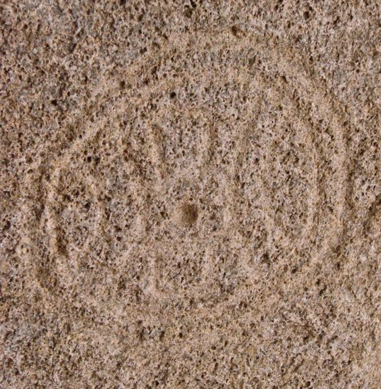
The name "Xihuacán" is seen here as a glyph, or carved stone symbol. Often, I have visited pre-hispanic ruins whose original names have been lost in the mists of time. Sometimes the only name is one given by the Spanish. In the case of these ruins, archaeologists found the
Xihuacán glyph buried in the ball court area and determined that it symbolized the ancient name. The meaning of
Xihuacán has been deciphered as "place of the people of the turquoise." This is a metaphor for "place of the people who control time." Tracking time through astronomy was a major preoccupation of pre-hispanic elites. Their ability to predict astronomical phenomena gave them the ability to "control" time, and therefore provided the justification for their position and privileges.
Archaeologists work to uncover a human skeleton. Notice the thin brush the woman is using to remove dirt from one of the bones. Delicate handling is extremely important and this is not only because the artifacts are often fragile. In archaeology, the term "context" refers to exact position of an artifact in relation to other objects around it, as well as its location in the various strata of earth covering it. In understanding the original use, meaning and cultural role of any artifact, the context can be even more important than the artifact itself, however beautiful it might be. This is why looting is such a tragedy. The "pot-hunters" literally destroy the past as they hack away at a ruin to retrieve a salable item. However, the real fault belongs more to the buyers of these items than to the often uneducated and desperately poor diggers. Typically the buyers are wealthy foreigners or even respectable museums. They know better, but close their eyes to the consequences of their greed. The residents of
La Soledad de Maciel are very poor, but some among them thought it important to contact the archaeological authorities after they became aware of the possible significance of the artifacts they were finding. INAH involved local people in the archaeological project, teaching them to be proud of their ancient heritage. As the site has developed, they have gained income from guiding tourists, and providing them with services. INAH officials believe that when local people understand how protecting a site provides more value than looting it, an ancient ruin will be more secure for the long term. (Photo above was part of a display at the INAH museum)
An ancient burial revealed. A total of eight burials have been found during various digs, all in the ball court area. All eight of the skulls showed deliberate deformation similar to that practiced in
Teotihuacan as a mark of beauty and status.The crossed white lines in the photo are strings that help divide the site into segments so that the exact location of each find can be documented. Local farmers had been turning up relics for centuries but had little understanding of their meaning. Some began to collect what their plows unearthed and to show them to outsiders. It was not until 1941 that photographs of some of these items reached Ignacio Marquina, then Director of INAH. Marquina suspected the presence of a major site in an area where it was long believed that no such ruins existed. In 1943, 1948, 1961, and the late 1980s there were small digs by various archaeologists. Finally, in 2007, INAH began a major project. Surveys of the area revealed the most important large ceremonial center along the
Costa Grande. The area was originally settled as early as 2500 BC by the
Cuitlateca people. The site was more or less continuously occupied by various cultures from then until around 1300 AD. There was a relatively brief period of abandonment around 450 AD because of the great tsunami. Some scientists believe that, because of its amazing continuity,
Xihuacán may prove to be as important as the far-better-known
Teotihuacan or
Chichen Itza. (Photo above was part of a display at the INAH museum)
The Ball Court
Variations of this game were played all over ancient Mesoamerica. Nearly every major pre-hispanic site contains a
ball court. The rules of the game seem to have varied somewhat from place to place. However, the general idea was to move a ball down the court in a way that was vaguely similar to a cross between football (called soccer in the US) and basketball. The ball, about the size of a grapefruit, was made of hard rubber and might be as heavy as 4 kg (9 lbs). The rules in many places prohibited contact between the ball and the players' hands or feet. Contact with the head, chest, shoulders, forearms, hips, and thighs was usually allowed. For protection, players often wore heavy leather and/or cotton padding around their waists, hips, and forearms, and leather helmets on their heads. In spite of this protective armor, players were sometimes injured or even killed when struck by the fast moving ball. (Photo of a display in the Museum of Archaeology in
Zihuatanejo)
Xihuacán's ball court is one of the largest in all of Mesoamerica. The court, originally known only as Mound A, measures 160 m (525 ft) long and 29 m (95 ft) wide.
I took this photo from a position about 2/3 of the way down the court. At the upper left of the photo, Carole and our guide Eric provide a sense of scale. The ball court at
Xihuacán is the part of the overall site that has been the most fully excavated. It was built with blocks of granite using clay as mortar. Like other courts in Mesoamerica, this one is long and narrow, with the walls sloping up to a flat top where the spectators stood or sat. Like many other ball courts in Mesoamerica, the one at
Xihuacán had stone rings set at the mid-point of each side of the court. One way to score was to pass the ball through the hole in the ring, a space not much larger than the ball itself. Needless to say, this must have taken a good deal of skill. The Mesoamerican ball game may have originated with the
Olmecs (1500 BC - 400 BC). A version of it, called
Ullama, is still played by indigenous people in Sinaloa State in northwest Mexico.
A partially excavated set of steps allowed players entry to the court. The bench-like structure at the base of the sloping wall was also part of the playing area. The meaning of these games to the various societies in Mesoamerica was complex. On one level, it was pure spectacle, enjoyed by all members of the society, and it may have involved heavy betting. On another, the game sometimes provided a substitute for war, with disputes between city-states settled on the ball court rather than the battlefield. There were also deep religious meanings involved. The
concept of duality was widespread in Mesoamerica and the game represented, in part, the on-going struggle between the god of the sun and the lords of dark underworld.
One of the ball court rings is on display at the INAH museum. As you can see, the hole through which a ball must pass to score is not large, only about the size of a man's head. The long shaft below the ring was apparently sunk into the ground in an upright postion, probably up to the line where the lighter and darker surfaces meet. The upright position is similar to the style used at
Teotihuacan, another indication of the far-reaching influence of that great Central Mexico empire. By contrast, the Maya at
Chichen Itza and the
Aztecs at Tenochtitlán used rings set high into the walls on the sides of the court. Carved around the stone ring are two intertwined snakes. They represent the elements of fire and water which, when mystically fused, become human blood. Blood was viewed as the food of the gods, necessary for the continued movement of the sun, stars, and other celestial bodies. This would indicate that the ball games involved human sacrifices, possibly of players at the end of the game. There is considerable dispute among archaeologists about whether it was the winning or the losing team that was sacrificed. Since sacrifices were sometimes considered to be a great honor, it may well have been the winning team, or at least its captain, who went under the knife.
A player cries out to his teammates as he fields the ball. This display was copied from an ancient document depicting the game. The long curving symbol emerging from the player's mouth is similar to the "speech balloon" in a modern cartoon. Notice the helmet and leather loin protector worn by the player. As the ancients saw it, the movement of the ball represented the movement of the celestial bodies across the sky. In modern terms, the game was a way of "keeping things rolling."
The Pyramids
The pyramids at Xihuacán are unique in the way they were constructed. The ancient architects used river stone and adobe, unlike elsewhere in Mesoamerica where carved limestone and lime-based mortar predominated. This pyramid is the one shown at the top of the photo of the site model (photo #2 of this posting). It is the most fully excavated pyramid, but even so it is still partly covered. In the center, you can see the great staircase the priests would have mounted on their way to a long vanished temple on top. This is one of seven pyramids found so far at
Xihuacán. Five of them, including this one, are on top of a great platform covering an area of 1 hectare (2.47 acres). The platform surrounds a sunken patio containing an altar located directly in front of the great staircase seen above. The altar was the focal point of astronomical observatories located on three surrounding hills.
The nine levels of this stepped pyramid represent a sacred number. Numbers were very important to the ancient elites of Mesoamerica. There were nine levels to the underworld, known as
Mictlan. At the underworld's ninth (bottom) level lived the god of death,
Mictlantecuhtli. I was eager to get closer, but a barbed wire fence blocked my way. Our guide, concerned about the site, as well as my safety, cautioned me to go no further. I had to content myself with telephoto shots of the pyramid. Hopefully, at a later date, the area immediately around the pyramid will be opened to the public.
The largest pyramid is still covered with brush and earth, awaiting future excavation. It sits directly across the road from the ball court, where I was standing when I took this photo. The nature of the surrounding terrain, as well as site restrictions, prevented me from getting more of a picture than you see above. However, the position of my car at the base of the pyramid provides a sense of the scale. The five pyramids sited on the great platform are collectively called Mound B. The highest point on Mound B (15 m or 49 ft) is no doubt the top of this pyramid.
La Soledad de San Maciel
Soledad de Maciel is sometimes called La Chole, after the stela shown above. It stands in front of the tiny church in the center of the pueblo. Our guide, whose full name is Eric Abarca Jaimes, was born and raised in this tiny town of 400 people who live in 80 houses. His parents and other relatives still live here. The locals subsist much as their ancestors have done for thousands of years, living on corn, beans, and vegetables, along with fish from the sea. During the colonial era, the Spanish introduced coconuts, adding another facet to the local diet. People here also grow tobacco, from which they produce handcrafted cigars, an additional source of income as well as personal pleasure. INAH's development of the
Xihuacán ruins has created new economic opportunities, through jobs at the dig itself, as well as in the construction and maintenance of the museum, and guiding tourists like Carole and myself. Eric wears an official identification badge from INAH and has been trained as a guide by the archaeological agency. He and the other guides buzz around the area on small motorbikes, looking for customers. All are volunteers, rather than employees, and work for the tips they receive. We tipped him generously, and I encourage others to do the same. These fellows are worth it.
Eric explains La Chole. The stela is a carved stone approximately 1.5 m (5 ft) tall. It was originally located in the ceremonial area of
Xihuacán but was later moved to the front of the church. The monolith is very old, possibly dating to the
Olmec era (1500 BC-400 BC), and may represent a corn god, or possibly a local ruler. It has become not only the nickname for
Soledad de Maciel, but the symbol for the whole
Xihuacán site. The stela shows a male figure, wearing a feathered head dress and a breast plate on his chest. His arms hang down to the belted loin cloth around his waist.
The three faces of La Chole. The most interesting part of the stela is the face, or rather faces. There are three, including a front view in the center, bracketed by left and right profiles on the sides. The meaning of this is obscure, but it may be part of the pervasive Mesoamerican cult of duality. In this interpretation, the face in the middle represents the unification of the dual opposing profiles. Mesoamerican people saw dualities in every aspect of life: light and dark, day and night, sun and moon, good and evil, life and death, male and female, and so forth in an almost endless series of pairs. The pairs were not seen as separate entities, but were complementary aspects of a unity, something like the Chinese yin and yang.
Inside the tiny church, a crucifix and the Virgin of Guadalupe stand side by side. The ancients would have seen this as another aspect of duality, with representations of male and female deities. The church was very simple and rustic, and all the more beautiful for it. Religious feeling runs deep in rural Mexico, although pre-hispanic religious practices often lie just below the surface in formally Catholic settings. Just another kind of duality, I guess.
Our guide and his family
Eric's parents' home was rustic but comfortable. His sister (left) and mother (right) posed on the porch while leaning against one of two hammocks available for a snooze on a hot afternoon. The weather on the coast of Guerrero is warm year-round, so little in the way of heating is necessary. There were a lot of trees in the yard, so their shade provides some natural cooling. An outdoor privy was located nearby, but it was clean and odorless.
In the open-air kitchen, Eric's mother prepares a meal the old fashioned way. This style of cook stove is popular all over the Costa Grande. It is usually made either from concrete, or plastered adobe. The upright walls of the fire pits have openings at the top narrow enough to set a pot. The slot in front provides an air flow as well as a handy way to feed wood to the fire. Except for metal pots--first introduced in colonial times--this method of cooking hasn't changed since the era of the Olmecs.
Eric's nephew cavorts on some feed bags in the front yard. He wasn't the least bit self-conscious, probably because he was so used to his uncle bringing visitors to the house. Kids are great photographic subjects. They are natural performers and many, like this little guy, love to be the focus of attention. He looked happy, healthy, well-nourished, and loved.
This stone tool, once used to create amate paper, was found by Eric's father in his corn field. The bark from the
amate tree was first soaked overnight to loosen and separate the fine inner fibers from the coarser outer ones. The tool would be held in the palm of the hand as the crosshatched side was pounded on the fine fibers while they lay on a flat surface. The pounding smashed the bark fibers and spread them out thinly. Once a flat sheet of proper thinness was ready, it was left to dry overnight.
Amate paper was used by royal scribes for official documents and to keep accounts, as well as by priests for religious writing. Sometimes it was given as a gift to neighboring rulers or favored nobles. Because of this close association with power and religion, the paper was not treated as a commodity. Certain villages were assigned to make the paper, which was then collected as tribute.
The extensive collection also included this stone phallus. Such objects were used in religious rituals and were closely associated with power and rulership. The family collection of ancient objects was extensive, with piles of stone objects lining one side of the house. There were manos and metates (used for grinding corn), stone axes, pieces of broken clay pottery and much more. Eric's father had been collecting the material for many decades.
An ancient stone face peers out from between two handmade brooms. Given that the area has been almost continuously settled for more than 3000 years, it is not surprising that so many artifacts have been found and more keep turning up. When, about 450 AD, a giant Pacific tsunami came flooding in from the nearby coast, everything was buried under huge piles of sand. This preserved a great deal that might otherwise have been lost. The temporary salinization of the soil prevented reoccupation for a time, but eventually Xihuacán was rebuilt and continued as an important religious and political center for another 700 years.
A grinning devil leans against two clay reproductions of La Chole. Eric's father makes clay sculptures to sell to tourists, and we were invited to inspect the inventory. The family was obviously so poor, and had been so generous in allowing us to wander around through their home, that we felt we should pick something out. I finally settled on a small clay crocodile, rendered with deft realism. My choice resulted in pleased smiles all around. My prize now sprawls comfortably on my computer table, smiling toothily as only a croc can.
Our next visit was to Eric's own home in San Jeronimito. Above, Eric cuddles his daughter who is regarding me with an expression of grave disapproval. I think she didn't like these strange-looking people taking the attention of her papa away from where it naturally belonged, on her. She warmed up a bit when I made it a point to show her the photo I had just taken. Eric, like most Mexicans I have met, is very industrious and has several gigs going at once. There was a tiny restaurant in the front part of his yard, and he told us about some cabins he was renting in the back of his property. We found him to be a charming fellow, and an excellent guide. Anyone wishing to line up his services in advance of a visit should call his cell number: 758-100-3341
The trees in Eric's back yard were swarming with large green iguanas. They blended so well with their surroundings that at first I couldn't find a good shot. Finally this fellow obliged me by pausing long enough for me to locate him and get focused. We enjoyed our entire visit to this area, from seeing the wonderful ruins and museum of
Xihuacán, to the unexpected pleasure of meeting and getting a peek into the lives of some of the local people. Anyone visiting
Zihuatanejo should definitely consider a stop in this area.
This completes Part 5 of my
Zihuatanejo series. My next posting will focus on the religious and artistic life of of
Xihuacán, with photos of many of the wonderful artifacts contained in the INAH museum as well as some from the Museum of Archaeology in
Zihuatanejo. I hope you have enjoyed this posing. I encourage feedback and if you would like to comment or ask a question, please do so by return email or use the Comments section below.
If you do leave a question in the Comments section, PLEASE leave your email address so I can respond.
Hasta luego, Jim


Dear Jim,
ReplyDeleteWhile browsing your blog titled Zihuatanejo Part 6 I became quite interested in the photograph of a glyph immediately above the section describing "The name Xihuacan." Could you clarify where the glyph comes from in terms of a specific monument? whether that monument is at a site or in a museum? and whether the glyph was accompanied by a numeral in the bar-dot system? Thanks so much for your help. You can reach me at urcid@brandeis.edu. Best!
Jim,
ReplyDeleteMy wife and I just returned from Zihuatanejo and we too visited the Xihuacan with our volunteer guide (can't recall his name). Just thought you may like to know that we were able to climb to the top of the partially excavated pyramid - in case you were thinking of returning. Our guide also took us to his home which was two or three doors down from the small church shown in your photos.
Thank you for putting together such a great blog.
Pat N.
electropat@shaw.ca
Winnipeg, Manitoba aka "Winterpeg"