Water plummets down into a deep canyon near Concepción de Buenos Aires. Las Cascadas Paraíso (Paradise Falls) is also known as
Las Cascadas Cruz de Tierra (Cross of Earth Falls). Mexican landmarks often have more than one name, often confusing those trying to find them. I chose to use
Las Cascadas Paraíso because that is the name given them by the restaurant at the top of the falls.The waterfall shown above is the last, and biggest, of a series of cascades that move down the canyon like stair steps. The Paradise Falls are located several miles southeast of the town of Concepción de Buenos Aires at the end of a dirt road that is generally passable for street automobiles. For a Google map showing the area,
click here.
El Llano de San Sebastian
The countryside leading to Las Cascadas Paraíso consists of a high, rolling plateau. The plateau, called
Llano de San Sebastian, has an altitude of 2100m (6890 ft). When we first visited Paradise Falls, wild flowers filled the lush fields we passed along the way. In the distance, we could see large orchards full of ripening peaches. In addition to orchards, we passed broad pastures where cattle and horses grazed. Cutting into the edges of the plateau are numerous deep canyons, including the one that forms Paradise Falls.
Mexican farmers are resourceful about using whatever materials are at hand. In this case, the fence posts are rough tree branches supporting strands of barbed wire. The grass was so deep and thick it almost made me wish I was an herbivore.
And speaking of herbivores... A sleek palomino horse munches contentedly near a field of maiz (corn).
Palominos are typically a light gold color with a white mane. They are very popular as parade horses because they stand out. For the same reason, they became popular in movie Westerns and TV shows. Movie star Roy Rogers had a famous palomino named Trigger that Rogers had stuffed and mounted after the animal died. Another palomino named Mr. Ed (who played a talking horse) had his own TV series.
Restaurant Las Cascadas Paraíso
At the end of the dirt road is a rustic, open air restaurant named after the Falls. The owner is a pleasant middle-aged woman who speaks only Spanish. We took note that the local
cerveza (beer) is inexpensive, priced at only $15 pesos/bottle. That works out to $1.18 USD, welcome news to thirsty hikers.
The restaurant sits on the crest of a hill overlooking the stream that leads to Las Cascadas. The cloth drapes you see above were pulled down because of the rainy, blustery weather during our visit. The steps leading down in the foreground give access to the stream and the trail to the Falls
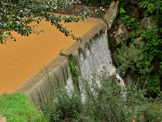
At the base of the steps is a large pond with an overflowing dam. The first of the cascades is actually man-made. The brown color of the water is due to agricultural run-off. We have found the same
cafe au lait color in several other creeks running off the
Llano de San Sebastian.
The Upper Falls
Below the dam, the first natural cascades begin. In the foreground you can see the path that parallels the stream down to the big falls at the end. The path is an easy walk, although I would strongly recommend good hiking boots or shoes because the way can be wet and slippery. As a matter of fact, I ended up on my butt at one tricky point. My companions enjoyed a good laugh at my expense, after they were assured that the only damage was to my dignity.
A wide variety of vegetation lines the stream banks. Three large maguey plants are grouped together on the far bank. When the water is not foaming white in the increasingly steep stream bed, it returns to its usual
cafe au lait color.
Maguey has been called "Mexico's Wonder Plant". The ancient indigenous people used it for building their houses, as wells as for twine, clothing, and food. In addition they used maguey to create an alcoholic beverage called
pulque, which is still consumed in rural Mexico. After the Spanish arrived, they introduced the distilling process and turned maguey into the drink called
mescal. Blue agave, a cousin of
mescal, is used to make tequila.
As you move down the canyon, the "stair steps" get steeper. The vertical drop in this waterfall is about 4m (12 ft). Off in the distance, I thought a could hear the roar of a much bigger waterfall.
Wild flowers form a delightful carpet along the banks of the stream. Eryngo (Latin: Eryngium) is a flower found primarily in grasslands. Many of the related species are used for food and sometimes to control inflammations. To those from north of the border, it seems odd at first that Western Mexico wild flowers bloom in Fall rather than in Spring. However, April through June is our hot, dry season. Fall is a cool, moist time of year that these flowers seen to love. My thanks to Ron Parsons, my flower expert, for this identification.
Foaming white water crashes down a another series of steps into a broad pool. There are actually several more cascades in the upper falls area than I show in this posting. I decided to limit my photo display to some of those that seemed more dramatic. Should you decided to visit
Las Cascadas Paraíso, you may be surprised at the number of lovely falls you encounter in this section of the stream..
Fruit sprouts from the paddles of nopal cactus. The
nopal is another of the wild food plants extensively utilized by ancient indigenous people. In fact, it is still harvested all over Mexico and is even sold at the supermarket where we shop. The green paddles can be prepared in a variety of ways, including sauteed and boiled. Served raw,
nopal is crisp, slightly tart, and would nicely complement a salad. The fruits along the edges of the paddles ripen into a deep red color. The
tuna, as the fruit is called in Spanish, is about the size of a hen's egg. After carefully peeling off the spiny skin, you will find the pulpy interior to be sweet and tasty.
Near the end of the upper falls, the canyon walls close in and the steps get steeper yet. The constant rising mist encourages the growth of moss and ferns along the water's edge, even as cactus grows a few feet away. At this point, the roar of the lower falls is clear, although they are still invisible.
The Lower Falls
Taking its final drop, the water of the lower falls crashed almost vertically into the canyon bottom. Photographing waterfalls is always tricky, particularly when done from the top. There weren't many vantage points from which I could safely shoot. At the lower right, you can just see the brown pool into which the lower falls flow. Without a point of reference, such as a human figure, it is difficult to appreciate how high the falls really are. At this point the walls of the narrow canyon form nearly vertical cliffs.
A closeup shot of the head of the lower falls. The pent-water blasts out in a curving arc as if from a fire hose. I took this shot with my telephoto zoom. Clambering about these slippery rocks would have been more than a bit risky.
My companions took a break on the viewpoint above the lower falls. From left to right are Phil, a Canadian, Mike, an American, Larry, another Canadian, and Martin, from Great Britain. Like me, Mike and Larry are full-time residents of Mexico. Phil owns a house here, but is a "snow bird" who splits his time between Canada and Mexico. Martin had just recently retired from his job as a homicide detective and was hugely enjoying his several-month Mexican adventure.
From the viewpoint, we could see a beautiful valley, lush and green, spreading out below. Although it is fairly wide, the low mountains ringing the valley give it a secluded feeling. This valley is typical of the many found nestling between the ridges of the Sierra del Tigre.
Directly below the viewpoint, the stream begins its flow down the narrow lower canyon. Once again, my telephoto lens makes the bottom seem closer than it really is. Our stroll down the path to the lower falls viewpoint was not tiring, and the lower canyon looked intriguing. There was no apparent route down from the head of the falls, so we decided to look for the canyon mouth and approach the falls from below.
The Canyon Bottom
Martin forces his way through the thick brush of the canyon bottom. After driving around hairpin turns down into the valley, we set off on foot in search of a trail that might take us to the base of the lower falls. This involved a good deal of what my fellow hikers euphemistically call "bush whacking." The process involves physically forcing your way through the brush, sometimes whacking at it with your hiking stick. I have broken several very good sticks this way. The brush often fights back with stickers and brambles that can leave bloody scratches on unprotected arms and legs. In this case, the brush was not only thick, but very wet.
We followed the stream, the only clear part of the jungly canyon bottom. The water still retained its
cafe au lait color, even after tumbling over multiple cascades on its way down the canyon. The light brown color contrasted nicely with the deep green of the forest vegetation.
Phil emerges from thick brush onto a narrow trail. He has just landed from a jump over a deep ditch and is balancing on his hiking poles. Like many hikers, he carries two poles, which look like ski poles without the little basket at the tip. They are adjustable to height and have grips that are molded to the hand. However, such poles can be expensive and I prefer an old handle from a mop or broom with rubber tips at each end. If I break one or lose it, the cost to replace it is negligible.
A large bromeliad grows out of the crotch of a tree. Bromeliads like this are distantly related to pineapples
. After a few hundred yards, we became so soaked from brushing against the wet vegetation that we gave up the effort to find the bottom of the falls. On a second attempt several months later, we failed again. That time we ran into a large swarm of angry, Africanized bees. Stumbling, flailing and tripping, we were pursued almost all the way back to our car. I didn't even realize that I had lost my hat and eyeglasses until I got back to the road. To the best of my knowledge, the lower canyon has yet to be explored by expat hikers.
This completes Part 2 of my Sierra del Tigre series. I always appreciate feedback, and if you would like to comment please do so in the Comments section below or email me directly.
If you leave a
question in the Comments section, PLEASE leave your email address so that I can respond.
Hasta luego, Jim


No comments:
Post a Comment
If your comment involves a question, please leave your email address so I can answer you. Thanks, Jim