Monday, April 28, 2014

Aguascalientes Part 1: Centro Historico and its Plaza de la Patria

This fountain is one of several at Plaza de la Patria in Aguacalientes' Centro Historico. The air is cool and moist around the dripping fountain near the Exedra Column. This makes it a perfect spot to pause on a hot day. Some of our friends had advised us that Aguascalientes is a city worth skipping because, in their view, it contains little of interest. Perhaps this attitude reflects the fact that the city is surrounded by several high-speed circumferential highways, giving it a "bullseye" appearance on a map and making the old city center easy to bypass. On a previous trip to Zacatecas, using one of these bypass roads, all we saw of Aguascalientes were modern industrial complexes and new suburban developments. This seemed to confirm the opinions of our friends. However, in the summer of 2013, we planned a trip to San Luis Potosi and decided to break the journey with an overnight stop along the way. A little Google research about Aguascalientes piqued our interest in its Centro Historico. The city is only about four hours' drive north from our home at Lake Chapala, so we arrived about mid-day. We left again the next day, also about noon. During this 24 hour period, I managed to take more than 400 photos! Our experience showed us that our friends could not have been more wrong. For a Google map to locate Aguascalientes in relation to Guadalajara and Lake Chapala, click here.


The Exedra Column and its park

The Exedra Column, and the park in its rear, occupy the eastern side of the Plaza de la Patria. The Plaza was laid out in 1609 and is 84 meters (275.6 ft) on a side. It is bounded by the Exedra monument and park on the east, the Cathedral on the west, the Palacio del Gobierno on the south, and colonial mansions (now commercial buildings) on the north. The Exedra Column, and the curved amphitheatre surrounding it, dominate the plaza. The original column was built in 1808 by architect and sculptor Manuel Tolsa. Born and raised in 18th Century Spain, he came to the Viceroyalty of New Spain (Mexico) in 1791 to head the sculpture department of the Academy of New Spain. He was committed to the Neoclassical style and led the move away from the prevailing Baroque style of New Spain. He is responsible for many famous architectural works in Mexico, including the final form of the great Cathedral in Mexico City.


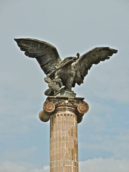
An eagle, eating a snake while sitting on a nopal cactus, surmounts the Exedra Column. This is the symbol of the nation of Mexico, and was not originally part of the column. Tolsa's work was completed just before the 1810 outbreak of the Mexican War of Independence from Spain. The column was intended to honor King Carlos IV. By the time it was finished, Carlos had died and his son Fernando VII had just ascended the throne. Therefore, a statue of Fernando topped the column when it was unveiled in 1808. Fernando's statue lasted only until the insurgent victory in 1821, when it was knocked down by the exuberant rebels. In 1949, a new column was built by architect Roberto Alvarez Espinoza, and in 1986 the eagle and snake were added at the top. The 1949 column and its amphitheatre were built with pink cantera stone and follow Tolsa's Neoclassical style, if not his political imagery. Tolsa died in 1816, so he never saw the destruction of his original work.


A crescent pool fed by vertical jets of water surrounds the back side of the Exedra monument. Buried in the base of the monument are the remains of Governor José Maria Chavez. He was a liberal hero executed by the French in 1864 during their five-year occupation of Mexico. Another hero, cultural rather than political or military, is honoured by the gold metal statue you see in the center-right of the photo. Manuel Ponce (1882-1948) was a composer of chamber and orchestral music. His works were heavily influenced by traditional Mexican songs. This scandalised the upper class during the Porfirio Diaz dictatorship because they were slavish in their addiction to European culture. However, it fit well with the revolutionary feeling of the post-Diaz era which sought to reconnect with Mexico's roots. One of the things I appreciate about Mexico is how the country honours its artists, musicians, writers, and great educators. Statues and other monuments to them fill parks and plazas all over the nation.


Sign of the times. Sitting on a bench near monuments to 19th Century heroes, a young father fiddles with his 21st Century electronic device. His wife watches skeptically, while his young son looks on, apparently disgusted that he is not the focus of all that attention. With a beautifully preserved historical center, Aguascalientes is one of the most modern, clean, and prosperous cities in Mexico.  It has always occupied a geographically advantageous position in the centre of the country. Since early colonial times silver shipments from Zacatecas passed through from the north. Commercial goods, in turn, moved up from from Guadalajara to the south. Aguascalientes has been further blessed with rich agricultural lands all around it. When the great railroad networks were built in the last quarter of the 19th Century, the city became a major hub, further increasing its importance and wealth. The people we saw seemed well dressed and prosperous, with cell phones and iPads and all the other accoutrements of modern life.


Another of the Exedra Column's fountains overlooks the Palacio del Gobierno. In addition to the jets in the pool behind the Exedra Column, there are two traditional fountains like the one above and in the first photo of this posting. In the background, the two-story Palacio del Gobierno (Government Palace) occupies half of the south side of the Plaza de la Patria. Once a colonial mansion, the Palacio  later became a government building.


The Government Palace

Palacio del Gobierno is the seat of the state government of Aguascalientes. A nun approaches across the wide Plaza from the direction of the Palacio del Gobierno (Palace of the Government). Along with the Palacio del Municipio (the municipal building) to its left, the Palacio del Gobierno forms the south side of the Plaza. The only side of the Plaza which is bordered by a street is to the north. This traffic-free zone avoids the noise, hazards, and air pollution found at plazas surrounded by auto-clogged streets. The Palacio del Gobierno was built in the 1660s as a mansion for the local bishop and is a fine example of late 17th Century colonial architecture. Prior to our visit to Auguascalientes, I consulted Richard Perry's website "Exploring Colonial Mexico." Much of my information about the architecture of the Palacio del Gobierno and the Cathedral comes from his website. I strongly recommend it to anyone visiting Mexico's old colonial cities and towns.


Five balconies adorn the front of the upper floor of the Palacio. Each is framed with elaborately carved limestone called chiluca. Another name often used for this stone is cantera. Above each doorway is the coat-of-arms of a wealthy family named Rincon Gallardo who owned the property for a period after it passed out of the hands of the Church. The rough reddish stone of the walls surrounding the windows and doors is called tezontle and is of volcanic origin.


The interior of the Palacio is a forest of columns surrounding a unique staircase. The staircase is in the shape of a cross. Steps lead up from the north and south and meet at a landing in the middle. From that landing, two other staircases lead up toward the east and west to the second floor. The east and west sides of the first floor are passageways formed by columns and arches called portales. The north and south stairways drop down into broad, tiled courtyards. The columns and courtyards manage to convey the impression of both openness and boundaries. Following the Rincon Gallardo period of ownership, the building became an inn. Then, in 1856, it became Aguascalientes' town hall, but later was taken over by the state government for its headquarters.


View from the second floor to the south courtyard. Many of the walls behind the portals are covered with large murals depicting dramatic scenes from Mexico's history. They were beautifully painted by Chilean artist Oswaldo Barra, a disciple of the great muralist Diego Rivera. In a future posting, I will walk you through the Palacio and show a few of the mural panels. Their effect on the viewer is intense. The scenes are thickly peopled and overlapping. Depictions of great peace and beauty are interwoven with other scenes showing the violence that has typified much of the drama and tragedy of Mexico's long history.

The Municipal building

The Palacio del Municipio is just east of the Palacio del Gobierno. Municipal governments are not just city governments as they are in the United States. A municipio is actually more like a US county. Municipios are typically composed of rural land and various towns and villages. The largest town or city in the municipio is the seat of government and almost invariably possesses the same name as the municipio itself. Aguascalientes is therefore not only the name of the city, and the state, but also of the municipio. Like much else in Mexico, this can be a bit confusing for newcomers
.

The courtyard of the Palacio del Municipio contains a fountain and a broad, double-staircase. The 100 meter (100 yd) wide property on which the building sits was originally given to Martín Fernández de Baulús and Gaspar de Aguilar as a merced (land grant from the Spanish crown) during the first part of the 17th Century. In 1665, after passing through several hands, the property was acquired by the Alcalde (Mayor) Don Juan Rincón de Vivar,  and the parish priest Don Pedro Rincón de Ortega, who also owned the great Hacienda Cienega de Mata outside the city. The two eventually decided to use as the site for a city hall. The building was constructed in 1700 and is of the Neo-classic style that was just becoming popular in Mexico.


A large and brilliantly coloured mural stands between the two great staircases. As is usual with Mexican murals, there is a lot going on in this one. The centre of the mural is the Exedra column, and the steeple of the Cathedral is on the upper left. The mural gives a feeling of looking up from the centre of the courtyard toward the sky. It is populated by a variety of figures, including folkloric dancers, charros (Mexican rodeo horsemen) in broad sombreros, factory workers, and many others. One can stand in front of a mural like this for a long time and still not absorb everything.


Carole stands between two of the great pillars that guard the front of the Palacio del Municipio. In the distance, one of the bell towers of the Cathedral rises toward the sky. Vendors have set up their stalls in the middle of the Plaza in anticipation of the fiesta for the Virgin of the Assumption (August 16-20).


The Cathedral

The Cathedral, viewed from in front of the Palacio del Gobierno. The church is known as the Catedral de Nuestra Señor de la Asunción (Cathdral of Our Lady of the Assumption). The property had originally been occupied by two chapels built in 1575 and 1605, respectively. In 1704, the priest Antonio Flores Acevedo started construction on the present church, but it was not until 1738 that his successor Manuel Colon de Larreategui finished the main building. Even so, the northern (right) tower was not completed until 1764 and the one on the south took until 1946. When Pope Leon XIII established a diocese in Aguascalientes in 1889, the church officially became a Cathedral.


Detail of one of the carved wooden panels of the Cathedral's great entrance door. In 1744, colonial architects Felipe de Ureña and Juan Garica de Casteñada built some wonderful retablos in the interior. Unfortunately, these have been lost during Mexico's subsequent turbulent history. In a future posting, we will take a much closer look at the Cathedral and its interior furnishings.


Random encounters around the Plaza

A narrow pedestrian street runs in front of the Quality Inn and ends at the Plaza. We stayed at the Quality during our brief stop over at Aguascalientes. A very modern and well-run hotel, it occupies the southwest corner of the Plaza. Importantly for a car-clogged city, it provides free off-street parking in its underground garage. Above, Carole strolls along the street, headed out on another adventure. Although you can see two cars parked on the left, this was only for loading/unloading purposes. The entrance to the hotel is under the flags on the left side of the photo.


The fiesta of the Virgin of the Assumption was in full sway during our visit. Looking out our hotel window, I saw this religious parade passing along the street seen in the previous photo. The procession was headed toward the Plaza and the Cathedral.


Indigenous dancers in colourful costumes formed part of the procession. The one on the left appears to be carrying a small bow and arrow in his left hand. It took only two years for the Spanish to conquer the powerful and civilised Aztecs to the south, but it took more than fifty to pacify the wild tribes who inhabited the Aguascalientes area. In fact, the Chichimecs, as the uncivilised, nomadic tribes of the north were generically known, had plagued every pre-hispanic civilisation for the previous 2000 years. The Aztecs themselves were a former Chichimec tribe who came south in a two-century migration that finally ended when they reached Tenochtitlán (modern Mexico City).


A musician set up shop just outside the front door of our hotel.  He was really quite good, at least to my unpracticed ear, so I made sure to drop some money in his horn case. One of the benefits of living in Mexico is that your life has a musical soundtrack. Everywhere you go there are musicians playing a variety of instruments. It's a hard way to make a living, so I try to be generous.


Sanborn's can be found on the northeast corner of the Plaza. Sanborn's is a chain of store/restaurants that has been a Mexican institution since 1903 but can also be found in El Salvador and Panama. The company was started by the brothers Walter and Frank Sanborn, Americans from California. At a location across from the main post office in Mexico City, they set up a lunch counter and soda fountain, the first of their kind in Mexico, The original Sanborn's is still in operation. The one above shares quarters with Hotel Francia, which was built in the French style in 1915


A double-decker tourist bus was parked in front of the Palacio Legislativo. The State Legislature building is located on the north side of the plaza, the only one bordered by a street. While we have ridden buses like this one in other cities, we passed on this one. Typically, the loudspeakers blare more loudly than I like, and virtually always in Spanish since most of the tourists are Mexican. Since the Centro Historico is fairly compact, and we had such a short time available, we felt it best to see the sights on foot. The tourist buses are not a bad option, and can even be fun, if you have the time and don't mind the blaring loudspeakers.


A croc to keep an eye on things. We encountered this fellow on the wall of a restaurant just off the Plaza on our first night. He was one of a number of critters mounted on the walls, including a rather bellicose looking hippopotamus. He was just another example of the quirky sense of humor you find everywhere in Mexico.

This completes Part 1 of my series on Aguascalientes. If you enjoyed it, I hope you will take the time to leave your thoughts in the Comments section below, or email me directly. If it says "no comments" it means no one has commented before you. Just click on that and it will take you to the place where you can leave your remarks or questions.

If you leave a question in the Comments section, PLEASE leave your email address so I can repond.

Hasta luego, Jim

Wednesday, April 2, 2014

Getting high on Tequila (Part 2)

A massive stone dome rises in the caldera of Volcan Tequila. This is a lava plug, the remains of the lava which congealed in the tube of the volcano. The surrounding material eventually eroded away, leaving a huge vertical monument to remind us of the volcano's ancient fury. What you see above is only about the top 1/3 of the plug. In the last posting (Part 1) we hiked up to the caldera rim, and then down inside it to the base of the plug. This posting will give you a feel for our climb around the base of the plug, and our return by a different, more difficult route than the one we used on our ascent.


Gary (left) and Jim B (right) pick their way carefully along a cliff face. It is a good idea to watch your step while hiking, but it is especially true up here where volcanic rock is rough and often jagged. It is at such times that a hiking stick is vital for testing the stability of rocks and acting as a third point of balance.


The face of the lava plug is very sheer. This telephoto shot only captures the top few feet of the face. The drop extends below it for several hundred vertical feet. The top and parts of the sides of the plug are covered with trees and other vegetation, in spite of the fact that there is very little soil. Life finds a way.


Kathy watches while one of the other hikers ascends a rock face. Kathy is one of the strongest hikers I know. Despite her petite size, she has tremendous stamina and can hold her own with any of the male hikers. She was part of a recent expedition by some of my hiking friends into the roadless jungles of northern Guatemala. It was a two-day slog (each way) through ankle-deep mud and extensive swamps. For 10 hours at a stretch, they followed the mule train that carries supplies to the remote archaeological dig at El Mirador.


Jim B tries his luck with a rock promontory adjacent to the lava plug. It was a tall jumble of broken boulders with trees growing out of the cracks. Getting around the trees was almost as much of a challenge as climbing up the boulders themselves. Jim B is within a few months of my age (66) and is in top shape. When he is not hiking steep mountain trails twice a week, he bicycles long distance. During his off-time, he goes to the gym. He organised the Guatemala trip.


Clambering the last few feet to the top, Jim grips the trunk of a dead tree. The climb didn't require technical gear or ropes, but was still risky. A fall, a twisted ankle, or a deep gash from a sharp rock would have created a real problem in terms of getting him down the mountain to our parked cars.


He made it! Jim triumphantly poses at the crest of the promontory. Now all he has to do is get back down again. This is no small task, because a climb down is always trickier than one going up. Most people who get hurt do so coming down.


Jim at the peak, a different perspective. Here you can get a sense of scale. From where I took this photo, the promontory is probably 40-50 feet high. However, it drops off at least 100 vertical feet to the right.


The return hike

Peter (left) and Kathy gingerly pick their way down from the base of the plug. After Jim B's safe return, we decided it was time to head back. We would be returning to our cars by way of the 2nd set of communication towers. They are located on the far side of the caldera rim from the towers seen in Part 1, and are separated from them by the yawning mouth of the volcano.


View of the back side of the lava plug. This side is every bit as rugged and vertical as the front side, although the drop from crest to base is not quite so far.


Kathy, Gary, and Jim B traverse the steep, grassy slope inside the caldera's rim.  In most places along here, the trail was less than a foot wide, and sometimes the drifts of oak leaves make it very indistinct. To the left, the slope continues steeply down hundreds of feet into the throat of the caldera.


Kathy and Ralph (left) approach the bottom of a cliff as Gary and Jim B begin their descent. The rough rock provided many hand and footholds, making it safer to climb down than if it was smooth. Still, losing your balance on a spot like this could be like sliding down a cheese grater.


Clumps of these Cirsium thistles grow all over the rim of the volcano. They are large, about the size of a baseball, and their flowers glowed a brilliant red in the sunshine.


Running out of trail, we spread out over the hillside, each picking our own way. This was one of the more difficult spots. Although there was little danger, it was physically more strenuous than the rock climbing. We fought our way up the steep slope through loose rocks and deep, slippery piles of oak leaves. Sometimes it was two steps forward and one back. At 9000+ feet, I found myself quickly tiring.


A view up the slope we were climbing. Up and up we climbed, with the crest never seeming to get any closer. The air was thin and I was panting heavily and needed to stop frequently to catch my breath. I did notice that Peter and Gary seemed happy to stop whenever I paused.


Peter, at the top of the ridge. He is from the Netherlands. Peter is physically tough and wiry, but he looked as bushed as I felt when we finally got to the rim of the caldera.


View of the first set of communication towers from across the caldera. The second set of towers is outside the frame of the photo to the left. The mountains of northern Jalisco and Nayarit loom in the background. The rim of the caldera curves around in the shape of a giant "U". The open side was created when the volcano exploded out toward the southeast tens of thousands of years ago.


Gary catches his breath on the rim of the caldera before the last push to the towers. He is a big, friendly, bear of a guy. Originally (and unmistakably) from New York, he spent the last part of his working life as a quality control manager at a large bakery company. After moving to Mexico about a year ago, he met his Mexican girlfriend Marina and they moved in together. Gary seems as happy as a bear that has found a big jar of honey.


The view out the open side of the "U" on the caldera's southeast side. The sheer wall to the right is the front of the lava plug, The wooded slope to the left is the rim of the caldera. An uneven checkerboard of cultivated fields spreads out across the valley far below. Most of the green fields you see are rows of agave cultivated by the tequila industry.


View from the valley southeast of the volcano, looking back up at the lava plug. The late afternoon shadows gather in the folds of the mountain as golden light slants across fertile fields. The position from which I took this photo looks almost directly back at the place where I stood to take the previous shot. We had stopped by the highway on our way home so I could get some final shots of the whole mountain. This is a beautiful area, well worth the two hours it took to reach it.

This completes Part 2 of my two-part series on our hike inside caldera of the Volcan Tequila. I hope you enjoyed it and got a good sense of the mountain and the area around it. I always welcome feedback and questions. If you have any, please leave them in the Comments section below, or email me directly. If no one else has commented yet, it may say "No Comments". Just click on that and the Comments page will open.

If you leave a question in the Comments section, PLEASE leave your email address so I can respond.

Hasta luego, Jim


Tuesday, March 25, 2014

Want to get high on Tequila? Try it this way...

The massive bulk of Volcan de Tequila is purpled by the late afternoon light. The first two times I climbed the peak of this volcano, I failed to bring my camera. On this sparkling, clear, winter day I made sure to pack my new Nikon. Volcan de Tequila, at 2,920 m (9,580 ft) dwarfs the other mountains in the area both in altitude and general bulk. It is no wonder that the people of the ancient Teuchitlán Tradition (300 BC-900 AD) considered it a sacred place. Aside from its impressive size, the volcano spewed forth immense quantities of volcanic glass called obsidian. This material was highly valued by pre-hispanic people because it could be shaped into tools, weapons, jewelry, and other useful objects. Obsidian can be honed to an edge finer than steel surgical instruments. Possession by an ancient society of such extensive deposits would be equivalent to possession of huge oil fields today. Notice the dome in the center of the volcano's caldera (crater). Our intent was to hike to the rim of the caldera, then down inside it to the base of the dome. We weren't going to attempt the last several hundred feet to the top of the dome because that would require ropes and technical climbing gear we didn't bring. To attempt the summit without such protection would be too dangerous. For a Google map showing the location of the volcano and its relation to Guadalajara and Lake Chapala, click here.


Approaching the volcano's caldera


The slopes of the volcano, right up to the caldera rim, are thickly covered by oak forest. My fellow hiker Jim B is seen above, walking along the cobble stone road that leads from the base of the mountain all the way to the caldera rim. The road was built to service the cell phone towers and other communication gear set up to take advantage of the volcano's commanding heights. The valleys surrounding the mountain are extensively planted with blue agave, the plant from which tequila, the Mexican national drink, is produced. The drink got its name from the small town of Tequila which sits on a plateau nestled against the northern flank of the mountain. Only the liquor produced in this area can legally be sold as "tequila." From the outskirts of the town of Tequila, the cobble stone road winds up the mountainside through innumerable turns and switchbacks. It took us nearly an hour to reach the gate where we left the cars. From there, the cobble stone road continues to the cell towers perched on the caldera's rim.


We found these lovely little flowers growing along the trail. They are of the Asteraceae or Compositae family, commonly known as asters. This is a huge family with 1,620 genuses and over 23,000 species. Members of this family can be found almost everywhere except Antarctica and the extreme Arctic. I want to thank Ron Parsons of Wildflowers and Plants of Central Mexico for this identification and his help in identifying the other plants in this posting. Ron always comes through for me, and usually on short notice.


View from the cobble stone road. The fertile valley below is bordered by the mountain ranges of northern Jalisco. The valleys around the volcano were settled by the Spanish early in the colonial period. Many ex-haciendas dot the landscape, some of them dating to the 17th Century when great herds of cattle roamed the area. In the 18th Century, some of the hacendados discovered a market for the tequila that they had been distilling for their personal use. While imported brandy and rum were expensive, tequila was relatively cheap since it could be made from the innumerable blue agave plants which grew wild in the area. Hacendados soon started distilling the liquor on a commercial scale. Well-known tequila brands such as José Cuervo, Sauza, and Orendain are all named after the original owners of 18th Century tequila-producing haciendas.


Gnarled oak trees cover the slopes of the volcano. Their spreading canopies provide welcome shade from the intense sun. Although at 3000 meters the air is cool, the direct sun can warm you up quickly. Unlike the mountains around Lake Chapala--except at the very tops--the slopes of Volcan Tequila are not jungly. In fact, there is very little underbrush between the great oaks, and even less so as you gain altitude. The ground is covered by layers of fallen oak leaves which may suppress the undergrowth. The open and park-like terrain is very pleasant to hike through.


A great valley spreads out toward the north. I took this shot standing below an electrical tower from which three power lines dropped precipitously down the slope to the next tower far below. In the foreground are the forested lower skirts of the mountain. Just beyond is open range covering a broad plateau. Beyond that, a long ridge descends from left to right. Behind this ridge is the gorge through which the Rio Grande de Santiago runs. The Santiago, one of Mexico's longest rivers, begins on the northern shore of Lake Chapala, cuts around to the north of Guadalajara, and then runs to the west through rugged mountains before finally emptying into the Pacific near San Blas. It's total length is 433 km (269 mi). The area you see above was a pre-hispanic transition zone between the settled and civilized cultures of Central and Southern Mesoamerica, and the wild, nomadic, and definitely uncivilized Chichimec tribes who inhabited the mountains and deserts to the north. Chichimec attacks plagued those early civilizations, just as they plagued the Spanish from the earliest colonial days until well into the 18th Century.


White pine stands regally erect among the oaks. While the oaks predominate near the top of the volcano, I found this white pine standing proudly among them. The white pine (Pinus flexilis) is found widely in the U.S. and in the western Sierra Madre mountains of Mexico.


Peeping through the trees, you can see the northern end of the lake called Presa La Vega. The town of Teuchitlán, which borders the lake, is obscured by the branches at the bottom of the photo. The Teuchitlán Tradition gets its name from this town. Nearby are the famous circular pyramids called Los Guachimontones, which were built in a late stage of the Tradition. In addition to its unusual cone-shaped pyramids, the Tradition is marked by the use of Shaft Tombs. These unique tombs are found extensively in this area, as well as in a large arc which includes Colima, southwestern Jalisco, and Nayarit. The Shaft Tombs were dug vertically into the ground as deep as 20 m (60 ft) using only wooden or bone tools. At the bottom, one or more bulb-shaped chambers were cut, extending off from the shaft. Bodies were arranged in the chambers like the spokes of a wheel, with the feet at the center. What we know about the Teuchitlán Tradition and its Shaft Tomb People comes largely from the artifacts left in their tombs as offerings. These include many fine sculptures, including women preparing meals, parents cuddling with a child or pet dog, and people playing musical instruments or dancing in a group. The sculptures provide a deeply touching window into a vanished past.


At the rim of the caldera, we encountered this simple iron cross. We often find such crosses on mountain peaks during our hikes. They are usually shrines to which local people hike as part of religious fiestas. Although this one was unadorned, others are often draped with banners and surrounded by potted flowers and votive candles.


A view from the rim looks across a valley to a lake and another volcanic peak in the distance. Also visible is a layer of smog which has drifted over from Guadalajara, 66.7 km (41 mi) to the east. Such smog can be a problem during the dry season (November - June). Guadalajara is Mexico's second biggest city, with 7 million people. However, smog prevention policies such as mandatory emissions inspections have been implemented and, with increased enforcement, the smog may eventually be brought under control.


Once on the caldera rim, we approached one of its two sets of cell towers. The other set of towers is about 0.8 km (0.5 mi) mile away on the other side of the rim. Both sets are visible from many miles away in the valleys below. The various installations included the one seen above, owned by Telcel. Others included a communication mast put up by the local fire department. Telcel is by far the dominant company in the Mexican cell phone market. It is owned by Carlos Slim, a Lebanese-Mexican who, with a reported net worth of $72 billion (yes, that's with a "b"!), is one of the world's richest men. Visible in the photo are Jim B (left) and Gary (right). The dog in the foreground is Matty, belonging to Chuck, another hiker. Matty is an enthusiastic hiker, loved by all for her sweet disposition.


Inside the caldera


The lava dome, seen from the first set of cell towers. The second set is to the right of the dome, beyond the edge of the photo. The ridge behind the dome is one side of the caldera rim. You are looking down into the mouth of the massive crater. Examining these photos now, I am struck by how small the dome seems. In reality it is a huge block of volcanic rock, impossible to capture all in one photo unless you are a considerable distance away. However, its imposing size is dwarfed by the caldera in which it sits. The dome is what remains of a lava plug which formed in the mouth of an eruption. The soil surrounding the cooled lava wore away over time, leaving this giant monument as a reminder of the volcano's power.


Chuck, owner of Matty, clowns around behind a hollow tree. Chuck is from Arizona and has lived, full-time, in the Lake Chapala area for a number of years. Even before that, he had been a regular visitor to many parts of Mexico. Chuck is an adventurous sort, and is always one of the first volunteers for a proposed expedition. His crusty exterior conceals a warm and generous spirit.


The rest of our Volcan Tequila crew poses with the lava plug in the background. From left to right are Jim B, Kathy, Peter, Gary, and Ralph. Jim is one of the leaders of the large, informal  group of hikers who participate in adventures like this one. Earlier this year, he led a group that marched for two days through the swamps of the remote and roadless Petén jungle of Guatemala in order to visit a archeological dig called El Mirador. Kathy and Peter also participated. More recently, Jim led a group on a climb of Nevado de Colima. At 4282 m (14,050 ft) it is Jalisco's highest peak. Keep in mind that none of the people you see above is under 60 years old, and some of them are well on the far side of that.


We encountered these large thistles growing in groups at various places near the rim. With its thorns and bright flowers, it is really quite dramatic. The Cirsium thistle is part of a genus with 60 species. It is also called a Plume thistle, for obvious reasons.


From the cell towers, we circled around the rim toward the lava dome. The dome can be seen through the trees on the upper  left. From the lip of the rim, the dry stone wall seen above extends far down into the caldera. We saw no cattle in the area, so the purpose of the wall was unclear. Consider this: whoever built it moved hundreds, perhaps thousands, of large stones by hand while working at an altitude in excess of 3000 m (9000+ ft). Local folks are certainly hardy.


Suitably enough, this is called the "Tequila" flower. Salvia gesneriiflora is found in the Sierra Madre Occidental mountains at elevations between 7,500-10,000 ft. In the wild, it can grow up to 25 ft high.

 
A view of the lava dome, seen from the side. As you can see, it is extremely steep on all sides, and some faces are almost vertical. Just to the right of the dome, you can see a small black bump of rock. The notch between the dome and the black bump was our goal.


The summit of the dome, seen through my telephoto zoom. My Nikon has a 42X zoom, and I needed all of it to get this shot. The top is wooded, except for a jumble of large boulders. It is not clear to me what might have caused this massive rock fracture. Usually something like this boulder pile is found at the base of a cliff, rather than at its top.


Our path now took us inside the lip of the caldera. To the left was a very steep slope down into the mouth of the caldera. The route here was more like the suggestion of a trail than something clear and distinct. I moved cautiously and examined the ground for evidence of human passage.


Looking up toward the lip of the caldera, the ground was covered by thick tufts of bunch grass. Rather than standing up straight, the grass was bowed over, as if a flood of water had poured down the slope. The rise of this slope is just as precipitous as the fall down into the caldera on the other side of the trail.


A volcanic monolith rose in our path, requiring some rock-scrambling to surmount it. Here, we rested and hungrily consumed some of the snacks we brought. I tend to favor a mixture of nuts, seeds, and dried fruit, along with some Ritz crackers. Sometimes I'll add a chocolate bar for extra energy. Along with a couple of liters of water, that generally tides me over until our traditional post-hike feast at a local restaurant.


Our goal comes into sight. The "small black bump of rock" I mentioned previously turned out to be not so small after all. The black rock is about 30+ m (100 ft) high, but it is a tiny speck compared to the lava dome, which looms on the upper left of the photo. Our route traversed the base of the black rock beginning at the lower right of the photo. This was followed by a rock scramble up into the slot where the black rock and the dome meet. In my next posting, I'll show our party climbing around in this area, and also our return, which was accomplished by a different route.

This completes Part 1 of my two-part series on our climb of Volcan Tequila. I hope you have enjoyed joining us on our adventure. I always appreciate feedback and questions. If you have any, please leave them in the Comments section below, or email me directly. If no one else has preceded you, it may say "no  comments." Just click on that and it will open the Comments window.

If you leave a question in the Comments section, PLEASE leave your email address so I can respond.

Hasta luego, Jim