Thursday, October 4, 2018

Ancient Oxtankah's Plaza of Bees

The pyramid known as Structure I is shrouded by ramón trees. In my last posting, I presented a broad-stroke picture of Oxtankah. This time, we'll take a detailed look at a plaza that is one of its main features. The Plaza de Abejas ("Plaza of Bees") was given that name by Alberto Escalona, the archeologist who excavated the ancient city in the 1937. He also named the city Oxtankah, which means "three neighborhoods surrounded by ramón trees".  The scientific name for a ramón tree is Brosimum alicastrum. The three neighborhoods referenced include the two main ceremonial areas, Plaza de Abejas and Plaza de Columnas, as well as Plaza de Tortugas, which lies between them. I will show these last two plazas in my next posting. What the ancient Maya called these plazas, or their city, is unknown.


Overview of the plaza


Detail from a site map of Oxtankah, showing Plaza de Abejas. For a look at the full map, click here. Shown above are six structures, laid out in a rough oval. At the lower left is Structure I, a pyramid containing two tombs. Just above it is an unnamed pyramid that I didn't photograph because it is mostly rubble. At the top is Structure III, a long, rectangular palace with a grand staircase in the middle. Structure IV, at the upper right, is a temple notable for a mysterious stucco inscription at its entrance and its odd, maze-like interior. At the bottom is another palace with a columned terrace and a spacious patio, but which lacked any informational signs. None of the various site maps I have since consulted gives it a name. In the center of Plaza de Abejas is a large altar containing two tombs in which multiple individuals were buried. I will show these structures in the clock-wise order I have just outlined.


The ancient Maya Bee God from a hieroglyphic text called the Códice Madrid. Beekeeping among Yucatan's Maya began as early as 300 BC and has continued into modern times. They favored the stingless bee they called xuna'an kab ("royal lady"). Modern science knows it as Melipona beecheii. The ancient people used their bees to produce honey, wax, and royal jelly. The honey was used for religious ceremonies, medicinal purposes, and as a sweetener. They also used it to brew balche, an hallucinogenic drink. When Spanish missionaries arrived, they reported a brisk trade of beeswax and honey for cacao beans, another highly valued commodity. The honey bee was so important to the Maya that it had its own god, Ah Mucen Cab, also known as the Diving God. Archeologists called him by that name because he usually appears as an upside down honeybee, as you can see above.


Structure I: The Pyramid With Two Tombs

Structure I is a partially excavated pyramid with a temple on top. The pyramid was constructed with four stepped-levels. The one-room temple, built on the top level, has three levels of its own. The grand staircase is a complex arrangement of stairs, which may have been the result of rebuilding over the centuries. At the foot of the stairs are the remains of three small square altars.


The grand staircase of Structure I, from the left. The pyramid, which is on the east side of the plaza, faces west in the direction of the setting sun. There is a structure in the foreground, at the base of the left side of the stairs, with a top that slopes upward. Its placement is puzzling to me because it seems to impede access to that side of the staircase. The ancient people did not build their sacred structures randomly, or without careful thought, so it may have some ritual function.


View from the fourth level looking down the steps at the small altars. While the steps don't look steep in the previous shot, from here you can see that they really are. This is the tallest structure in Plaza de Abejas and from it the Maya priests could view all the other structures in the plaza. Today, so many ramón trees have grown in the plaza that other structures are hard to make out. The pyramid was built around 300 AD, and functioned until about 600 AD, at which time much of the city was abandoned. Later, in 1000 AD, the city was re-occupied and another structure was built over this one. This was a common practice in ancient Mesoamerican cities. The later structure was still in use when the Spanish arrived in the 1500s. Archeologists removed much of the later structure in order to reveal the original.


The temple has a single, short staircase which leads to a rectangular room. In this room, the Maya priests would perform those parts of their ceremonies that were restricted from the view of the uninitiated. Small bone fragments and teeth from at least 20 individuals were found within the altar of this temple. Similar fragmentary remains of 29 other individuals were found within the two tombs located underneath the temple. It appears that the primary function of the pyramid and its temple was funerary. There is nothing to indicate that any of these individuals were sacrificed. All 49 were adults, according to the analysis of their teeth, but scientists have been unable to identify the sex or age of any of them.


Tomb 1 is entered from the rear of the temple. The rectangular, stone-lined crypt above can be found just inside. The fragmentary remains and various grave goods have been removed for safekeeping. On the wall of the crypt is a niche which once contained sacred objects. The grave goods indicate that the remains of at least one occupant were those of a ruler or other person of great importance. This tomb dates to the period between 300-600 AD and is the earliest explored to date. The pyramid's Tomb 2 was looted, probably during the Epi-Classic Era (600-900 AD) when the city was abandoned for 300 years. The looters left only four objects behind.


How the tomb would have appeared when the ruler was buried. The body would have been placed on its back with the head toward the north. In the Maya view of the Cardinal Points, north was not just a direction. It also indicated the sun's highest position, or zenith. Fifteen objects, known as "grave goods",  were placed within the crypt.


Structure III: The Long Palace

Structure III is the long, rectangular structure seen through the trees.  Here, you are looking southeast from the base of Structure I across Plaza de Abejas. I have dubbed Structure III the "Long Palace" because its length is 60 m (197 ft). At Oxtankah, the palaces of the principal elites were placed around the various plazas and the Long Palace occupies the whole south side of this one. Even at this distance, you can see that the palace's main staircase is quite impressive. The open area of the plaza is quite large and must have been the site of impressive ceremonies involving large numbers of people.


The main staircase of the Long Palace. As usual in Mesoamerican buildings, most of the steps are high and narrow. The palace extends beyond the end of the stairs in both directions. The main building was constructed between 300-600 AD and during this period an adult individual was buried within it. Archeologists believe that this staircase was added later, perhaps after 1000 AD, in the Post Classic Era.


View along the top of Structure III from the right end. You can see the remains of a couple of rooms in the foreground and there are others at the far end beyond the stairs. Rooms made of perishable materials once stood along the top level, but these have long since disappeared. The rooms in this palace were not exclusively for living quarters, but also functioned as reception areas for visiting dignitaries, for administrative matters such as tribute collection, or for storage.


Several rooms are built into the body of Structure III. The one above includes a small staircase. The interiors of the rooms would have been furnished with rugs, cushions, textiles, and various wooden objects. Unfortunately, none of these has survived. The dimensions of the rooms are quite small and would have been dimly lit during the day. Why would privileged elites live in such places? In Yucatan, the climate makes it possible to live outside year-round, so the ancient Maya carried out most activities on the terraces, patios and courtyards. The rooms were used for sleeping or when they desired privacy.


View of the five stepped-levels of the palace. Notice how some of the corners are sharp, while others are gracefully curved. The curved corners are characteristic of the Petén architectural style which dominated northern Guatemala and the Southern Yucatan Peninsula from the Pre-Classic Era to the Epi-Classic. Lime-based stucco once coated the walls, which were painted with multi-colored pictures and designs. The subjects of the paintings were the histories of Oxtankah's rulers and gods.


The Central Altar & Tomb

It was a common custom to place an altar in the middle of a plaza. This may be linked to the belief that the Cosmos had five Cardinal Points. These were north, south, east, west, and the center. The sides of the plaza were oriented to the first four points. The placement of an altar in its center thus linked the whole plaza with the Cosmos. The altar was constructed during the Epi-Classic Era (600-900 AD). This was hundreds of years after most of the other structures surrounding it had been built and during a period when Oxtankah had been abandoned. Some time after 1000 AD, when the city was re-occupied, another alter was built over this one. The newer altar was still in use when the Spanish arrived, five hundred years later. The palm-frond palapa shelter, seen above, protects a tomb.


Three tombs were found within the altar, including the one above. The skeleton is a facsimile created to give visitors an idea of the tomb's contents when archeologists opened it. The body was placed on its back, in the position shown above, with the head facing north. Interestingly, no grave goods were found. Lining the inner sides of the crypt are thirteen flat upright stones, possibly representing the thirteen levels of heaven in the Maya cosmos. Other large flat stones were placed across the upright stones to form a lid over the crypt. No information was available about the contents of the altar's two other tombs.


Structure IV: The Temple of Inscriptions

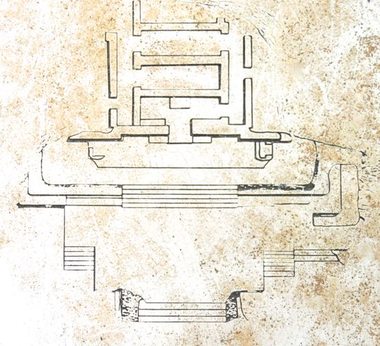
Diagram of Structure IV showing its main features. At the base is a broad platform, which forms a terrace. This stretches out into the plaza and is accessed by multiple staircases. A second platform sits at the back of the terrace. It is accessed by a single broad staircase. The temple stands on top of the second platform and is entered by a narrow doorway. At the base of the step in front of the doorway is a series of mystic symbols formed with red-painted stucco. Inside the temple, the first room contains a stone altar. Other connecting rooms are arranged in an unusual maze-like pattern that probably had some sacred meaning. Structure IV was constructed between 300 and 600 AD. Some time during this period an adult individual was buried here. Between 1000 AD and the arrival of the Spanish, the structure was modified several times.


The temple viewed from the front right. The original temple would probably have had a similar covering to the palapa above. This palapa was constructed by archeologists to protect the temple and its inscription from the elements, The temple faces toward the east and the rising sun, which is also the direction from which Venus rises as the Morning Star. To the ancient Maya, Venus represented the cyclical pattern of fertility and regeneration.


The entrance to the temple's "inner sanctum". The rust-colored inscription can be seen on the step below the passageway. The surface of the terrace floor in front of the temple's entrance is made from lime stucco. The widespread use of this material to cover walls, floors and road surfaces led to deforestation throughout the Mesoamerican world. Some of the consequences of deforestation included drought and crop failures, probably followed by wars, famines, and epidemics. This, in turn, led to the abandonment of cities and population migrations. Oxtankah may have experienced some of this after 600 AD, when it was largely abandoned. Its re-occupation around 1000 AD may have been linked to the regeneration of the forest.


Closeup of the inscription. In the center is what looks like a sort of exclamation point. Some, but not all, of the symbols on each side replicate those on the other. Archeologists have deciphered the various symbols as the eyes, nose, upper lip, teeth of a jaguar, along with its clawed paws. Also included are seashells, snakes, concentric circles, and a lunar eclipse. Each of these had a sacred meaning, but exactly what they meant as a group is still a matter of conjecture.


The "exclamation point" turned out to be the nose and nostrils of a jaguar. Two eyes used to frame the nose but, except for traces, they have long since disappeared. The lines extending out from the nostrils on either side represent the upper lip with large teeth hanging down below. The jaguar was a sacred animal not only to the Maya, but to ancient people throughout Mesoamerica. It is the third largest of all cats, after the African lion and Indian tiger. As a powerful hunter, the jaguar symbolized attributes that were very attractive to ruling elites. Because they hunt at night, ancient people believed that jaguars could pass freely between the worlds of the living and the dead. Other powerful animal symbols in the inscription include coiled snakes and conch shells. Snakes were associated with Kukulkan, the War Serpent, and conches with Chaac, the rain god.


The front room of the temple contains a large, rectangular altar. The altar faces the entry and would have been illuminated by the rays of the rising sun. Maya priests used the interior rooms of their temples to conduct those rituals and ceremonies that persons of lesser status were not privileged to see.


This carved stone decoration bears a striking similarity to the temple's interior. The decoration can be found in the small museum near Oxtankah's entrance. There was no sign to explain where it was originally uncovered or what it might mean, but I was struck by the similarity of its pattern with that of Structure IVs temple interior.


The Nameless Palace 

Another palace occupies the north side of Plaza de Abejas. There was no sign giving it a name or any description. The palace's rooms surround a patio on three sides. The main building, seen above, sits on a broad platform and has a terrace with a line of columns along its front that once supported a sheltering roof. A single small staircase lead up onto the platform. The area covered with green grass is the patio, set a couple of steps up from the surrounding ground.


The patio, as seen from the terrace. The stump of one of the columns is in the right foreground. Long, narrow rooms border the south and west sides of the patio. The room on the west side has an entrance from the patio in its middle. In the southeastern corner, there is a structure somewhat resembling a defensive blockhouse. However, I saw no other signs of defensive works at Oxtankah, so the purpose of this structure remains a mystery to me. The patio and terrace are the most likely gathering places where residents would have socialized among themselves, entertained guests, or worked.

This completes the second of my Oxtankah series. I hope you have enjoyed it and, if so, please leave any thoughts or questions in the Comments section below, or email me directly.

If you leave a question in the Comments section, PLEASE leave your email address so that I can respond.

Hasta luego.


Monday, September 24, 2018

The ancient Maya city of Oxtankah

View of the left side of Oxtankah's Structure I. This pyramid's rather unromantic moniker was given by the archeologists who excavated it. Notice how Structure I was constructed with rough rocks and rubble, then covered by a layer of finely cut stones. The pyramid has four stepped levels, with a temple on top and two burial chambers. Oxtankah is probably the easiest ruin to reach from Chetumal, the capital of Quintana Roo. It is located 16 km (10 mi) north of the city, near the shore of Bahia de Chetumal.

In spite of its convenient location, the site was nearly empty of tourists. This is not unusual, since the vast majority of Mexico's wonderful pre-hispanic ruins get few visitors, even though the sites are usually well maintained and marked with informational signs in both Spanish and English. Only a few large, well-publicized sites, like Teotihuacán and Chichen Itza, get significant numbers of tourists.


Site map of Oxtankah. The sign above shows an elite ceremonial area which contains two plazas, each surrounded by pyramids, temples, and palaces. The structures shown are the only ones that have been completely excavated, although a number of unexcavated mounds dot the area. In this posting I will give you a general overview of Oxtankah. In the next, I will focus on the Plaza de Abejas (Plaza of Bees), seen in the center of the sign. In my final posting on Oxtankah, we'll look at the Plaza de Columnas (Plaza of Columns) at the top. The ancient city originally contained at least 100 buildings and extended as far as Isla Tamalcab in Bahia de Chetumal.


Ramón tree, with its characteristic root system. Oxtankah means "three neighborhoods surrounded by ramón trees." It is a name invented by archeologists. What the ancient Maya called their city is a mystery. The ruins are shaded by deep jungle and the only sounds your hear are from birds and the wind rustling through the trees. During our visit to Southern Yucatan, we stopped at ten ancient Maya sites, including this one. There were never more than few other visitors at these places and sometimes our car was the only one in the parking lot. In our opinion, this is the very best way to experience ancient ruins.


Trees and other vegetation are not the only living things that inhabit the ruins. A trio of iguanas sun themselves on the rock wall of a palace. These are some of the easiest of all animals to photograph. Iguanas will lie motionless for long periods of time, even in the presence of people. Perhaps they just like to pose for photographers like me. Mexican Spinytail iguanas (Ctenosaura pectinata) are very social animals, unlike other species of iguanas, who tend to be solitary. They like rocky areas with plenty of crevices to hide in, although the ones above don't appear much inclined to conceal themselves. They inhabit dry forests near both coasts of Mexico and Central America.


Detail from a Maya codex showing a figure paddling a canoe. The objects in the bow appear to be trade goods. The economy of Oxtankah was closely attuned to the resources of the nearby Caribbean, including fishing and salt production, while agriculture and hunting played a lesser role. Proximity to the ocean also encouraged seaborne trade. Oxtankah's inhabitants were skilled navigators and readily made their way up and down the Caribbean coasts of both Yucatan and Central America. The dots and lines at the top of the codex are part of the Maya numeric system. A dot is a 1 and a horizontal or vertical bar is a 5. It is not clear what the numbers represent, although they may be dates.


Structure X of the Plaza de Columnas. The columns on this temple are among those that prompted archeologists to give the plaza its name. Oxtankah flourished as a coastal trade center between 200 AD and 600 AD, during the Classic Era of pre-hispanic Maya culture. After 600 AD it was largely abandoned and left to crumble for the next 800 years. In the 1400s, the city was re-occupied and re-built, using materials from the Classic Era ruins. When the Spanish arrived in the 1520s, Oxtankah was still inhabited and evangelizing Franciscan missionaries built one of their signature "open chapels" adjacent to the pre-hispanic ceremonial center.


Pot lid decorated with a handle in the shape of a bird's head. The pot may have been made locally, although it may have been a trade item brought from elsewhere. One attraction of maritime trade for the Maya of Oxtankah was the ability to transport large amounts of goods with less effort and expense than would have been necessary to haul a similar amount overland. There were no animal capable of carrying a load, nor were there wheeled vehicles. Everything had to be transported on the backs of human porters. Another benefit from carrying goods in a canoe was probably a lot less breakage than with land transport. However, storms and rough seas were always a danger.


Structure VI in the Plaza de Columnas contains the tombs of several high status individuals. The two plazas were part of an area reserved for the nobles, priests, and rulers. The common people lived outside this area in oval-shaped huts called nah, which were constructed with mud and wattle walls and had thatched roofs. Modern travelers through Yucatan's rural areas will find many Maya living in structures that closely resemble the homes of their Classic Era ancestors.


Diagram of Tomb 2, Structure VI. This particular tomb contained a single body, that of an adult male, unclothed except for a loin cloth. Buried with the body were various grave goods, including several pots. Tomb 2 was located under the main staircase, apparently a spot of honor within the pyramid. The pyramid itself was an important structure within the overall complex. Both of these factors indicate that the person laid to rest in the tomb was a particularly high-status individual.


Room within the left end of Structure III. This structure is a palace, which occupies one whole side of the Plaza de Abejas. The room may have been used for residential or administrative purposes, or possibly for the storage of household goods. There are additional rooms on the opposite end of the long rectangular platform. Other rooms, made of perishable materials, are believed to have once stood along its top.

Limestone is easily available throughout the Yucatan Peninsula. Consequently, it was widely used to construct Maya cities. In fact, the entire Peninsula is composed of a thick, flat shelf of limestone, covered by a relatively thin layer of topsoil. The shelf was created millions of years ago by the steady accumulation of shell, coral and fecal debris on the seabed. The calcium carbonate rock is relatively light, easily carved, and therefore ideal for the construction of temples, pyramids, and palaces, as well as for stelae, sculptures, and other artistic purposes. Limestone was also burned to create the stucco which covered the walls of the various structures. In addition, the stucco was used to surface patios, courtyards and the lengthy sacbeob (roads) that ran for many kilometers through the jungle to connect the ancient cities. The production of large amounts of stucco necessitated a great deal of firewood. Over time, this resulted in widespread deforestation, which may have caused droughts and crop failures and contributed to the decline of the Classic Era Maya civilization.


Pot, in the shape of a melon. Ancient potters often used the shapes of melons, gourds, and squashes as patterns for their creations. This pot might have been used for food storage, cooking, or serving meals, just as today's pots are used. The collection of water is another possible use. Fresh water has always been scarce in the Yucatan Peninsula, which has almost no above-ground rivers. This is another result of the limestone shelf under the topsoil. Limestone is very porous and, consequently, water doesn't remain on the surface but seeps down into underground rivers and aquifers.

In the northwestern part of the Peninsula, there are large numbers of cenotes (deep sinkholes) full of fresh water. These deep circular holes were created when water seeped through cracks, dissolving the limestone. Eventually, the weakened limestone collapsed into an aquifer, making a cenote. The southern part of the Peninsula has very few cenotes. The cracks which allowed for their creation were the result of a meteor impact 60 million years ago, just off the northwest coast of Yucatan. This was the same meteor that scientists believe killed off the dinosaurs. Lacking cenotes, the Maya of the southern Peninsula cut water storage pits, called chultunes, into the limestone. They then dug drainage channels to direct the rainy season's runoff so that it would collect in the chultunes and could be stored for the dry season.


Temple located on the top level of the pyramid called Structure I. It is likely that the temple had a thatched roof at one time. However, unlike limestone structures, such perishable materials don't survive for millennia in Yucatan's climate. Archeologists found two tombs in Structure I. One of them can be accessed through the back side of the temple above, and I will show it in my posting on the Plaza de Abejas.


Carved limestone decoration from one of Oxtankah's palaces. The softness of limestone meant that it could be easily carved using the tools available. These didn't include any metal objects. The ancient Maya were sophisticated in subjects such as astronomy, mathematics, and calendars, but they were still essentially a stone age culture. Their tools were made from stone, obsidian (volcanic glass), and bone. Copper tools were used during the Post Classic Era by some of the cultures of western Mexico, such as the Tarascans of Michoacan, and the small kingdoms around Colima. These people learned how to smelt and work copper from their coastal trading connections with the ancient Peruvians. Although copper tools never reached the Maya, decorative copper objects such as ornaments and bells did reach Yucatan through the trade networks.


Stela and altar, near the entrance of Oxtankah. The faint outline of an elite figure, possibly a priest or warrior, can be seen on the upright slab. Circular stone disks are often found in front of stelae and were probably used for the placement of offerings. A great deal that we know about the Maya has come from deciphering hieroglyphs on stelae. The "Maya code" was not broken until the 1970s and, when it happened, it forced archeologists to radically change their perceptions of who these people were and how their societies operated. For a long time, the Maya had been viewed as peaceful star-gazers who occupied their lives with complex mathematics and mystical calendars. The deciphered hieroglyphs revealed, however, that warfare and bloody sacrifices played a large role in Maya culture. Regrettably, they turned out to be pretty much like everybody else.


One of the numerous unexcavated mounds found in and around Oxtankah's ceremonial center. There are probably many more of these than there are structures that have been fully excavated. Given the limitations of funding for archeological digs, it was once believed that it might take decades or even centuries to fully explore the various cities of the ancient Maya world. In fact, a new technology called LiDAR (Light Detection and Ranging) is revealing that many ancient sites are vastly larger than anyone ever imagined. LiDAR is capable of peering through previously impenetrable jungle canopy to see the structures hidden beneath. The lowland Maya areas, of which Oxtankah was a part, were once thought to have had a population of 5 million. LiDAR has revealed that it was more like 10 to 15 million. Stay tuned for more revelations!

This completes my first posting on the ancient Maya ruin of Oxtankah. I hope you have enjoyed it and, if so, you will leave any thoughts or questions in the Comments section below or email me directly.

If you leave a question in the Comments section, PLEASE leave your email address so that I can respond.

Hasta luego, Jim


Tuesday, September 11, 2018

Chetumal's Colorful Carnaval

A masked beauty rides one Chetumal's Carnaval floats. Although Carole and I were vaguely aware that Carnaval was approaching, we had no idea we would arrive right in the middle of the multi-day celebration. Instead, we had come to the Southern Yucatan Peninsula to explore the many ancient Maya ruins in the area. We needed a "base camp" for our visit and Chetumal turned out to be ideal.

The city is the capital of the Mexican state of Quintana Roo (pronounced "Keen-tana Row"). The Yucatan Peninsula contains three states: Yucatan in the north, Campeche in the southeast, and Quintana Roo, which stretches along the Caribbean shore and extends inland to meet Campeche in the south central area. This series will cover our exploration of southern Quintana Roo and eastern Campeche. To view this area on a Google map, click here.


Chetumal

The Palacio Gobierno faces Chetumal Bay, which opens onto the Caribbean Sea. The Bay, located at the southern tip of Quintana Roo, is shared with the neighboring country of Belize. Mexico's border with Belize is only a short distance from the city. The Palacio Gobierno (Government Palace) is the state capital building and is one of the few structures that we found to be architecturally interesting in Chetumal.

Founded in 1898, the city was originally called Payo Obispo (Bishop Payo). In 1936, the name was changed to Chetumal, in honor of ancient Chactemal. That Maya kingdom once included parts of southern Quintana Roo and northern Belize. Because Chetumal was not founded until the very end of the 19th century, the city lacks the graceful colonial-era buildings you find in Mérida,  Campeche, and other Peninsula cities.

Up until the middle of the 20th century, Chetumal did contain a lot of interesting Caribbean-style wooden structures. Unfortunately, these were largely swept away by two hurricanes in the 1940s and a huge Category 5 storm in 1955. Since then, structures here have been built using modern glass, steel, and cinderblock. Carole and I have a taste for Mexico's elegant colonial architecture, so we found Chetumal's buildings to be rather bland and uninteresting. Still, the city has lots of modern conveniences.

Our hotel, the Fiesta Inn, was clean, comfortable, up-to-date, relatively inexpensive, and had an excellent restaurant and off-street parking. The hotel also contained a branch office for National Car Rental. Its very efficient staff rented us a car for our visit. The hotel is only about a 15 minute drive from Chetumal's small, modern airport. All of this made the city an excellent base from which to explore the area.


Chetumal's malecon at dusk, looking east. Just about every coastal city in Mexico has a malecon, or waterfront walkway. The one in Chetumal is unusually long, making it the best feature of the city. Ideal for strollers, runners and bicyclers, the malecon winds for miles along the shoreline, past lighthouses, through mangrove swamps, and around out-thrusting points of land.  The early town was focused on fishing and seaborne commerce and therefore grew from the shoreline into the hinterlands.

Unlike Mexican cities of the colonial-era, there is no "centro historico" in Chetumal. Spanish King Phillip II issued his Law of the Indies in 1573, establishing a standardized urban plan for all Spain's colonies. Under it, all cities had to contain a plaza in their center, bordered by a government building, the main church, and the mansions of the wealthiest residents. Neighborhoods were built around this center in concentric circles, with the poorest people (usually indigenous) in the outermost areas. Since Chetumal was built almost entirely in the 20th and 21st centuries, it has no such urban plan. The closest thing to a centro is the area immediately around the Palacio, near the western end of the malecon. 


A statue honoring Chetumal's fishermen stands on the edge of the malecon. The fishing industry has been largely eclipsed by national and international trade, although the city still has many restaurants where you can get decent seafood. Quintana Roo only gained statehood in 1974. Most of it is still farmland or jungle, although the development of Playa del Carmen and other areas of the "Costa Maya" is proceeding rapidly.

Until about 1950, Chetumal's population was only about 5000 people and there were few passable roads between it and other parts of the Peninsula or Mexico. However, the city is now connected to a network of modern, well-maintained highways. One of the most important is Highway 307, which heads south from Cancun along the length of the Caribbean coast to Chetumal. The second is Highway 186, which heads east from Chetumal, across the neck of the Peninsula to the Gulf of Mexico. These two major routes enable commerce between Chetumal and other Peninsula cities, as well as with the rest of Mexico.

In addition to being the point where these two important highways intersect, Chetumal has also benefited from its proximity to Mexico's chief border crossing into Belize. Its strategic location, and its status as state capital, have brought much prosperity to the city. By 2010, Chetumal's population had grown to more than 150,000.


Ronald McDonald takes it easy on one of the malecon's benches. I am always amused by the quirky statues one finds in public places all over Mexico. There wasn't anyone selling burgers nearby, nor did the statue have any obvious commercial purpose. Ronald was just sitting there, evidently enjoying the hustle and bustle at the temporary booths set up along the malecon during Carnaval. Why is he there? The question can only be answered by a Mexican-style shrug of the shoulders and ¿quien sabe? (who knows?)


Garden hybrid Pelargonium, often mistaken for a geranium. My flower expert, Ron Parsons, identified this as a Pelargonium. He publishes a website called Wildflowers and Plants of Central Mexico and always comes through for me, even on the short notice I usually give him. Carole and I came upon this gorgeous flower as we strolled the malecon one evening. One of the many wonderful aspects of Mexico is that something is always blooming, no matter what time of year. We visited this area in February, when drifts of snow usually blanket much of the US and Canada. Yet, here, the weather was balmy, with beautifully blooming flowers greeting us at every turn.


The low, whining buzz of a drone attracted our attention during our malecon stroll. I know some people like these devices and perhaps they have some useful properties. Personally I find their sound annoying and their presence intrusive. This is especially true when the drone is armed with a video camera, as this one is. I used to be fairly good at skeet shooting. If it would not get me in serious trouble with the Mexican authorities (it would), I'd practice on these things when I encounter them. This particular model hovered over the malecon for some time, setting my teeth on edge. We finally moved down the shoreline to get away from the noise and the camera.


Sunset over the malecon, looking west. The long pier jutting out is the Water Taxi terminal. From there you can cross Chetumal Bay to Ambergris Caye and Caye Caulker, both in Belize.  What looks like a lighthouse is actually the Obelisco a la Bandera y El Reloj (Obelisk to the Flag and the Clock). The tall, four-sided obelisk was inaugurated in 1943. Engraved on three of the sides are the names of the heroes of the Independence War of 1810, the Reform War of 1857, and the Revolution of 1910. There is also a clock on all four sides. The monument withstood the great hurricanes of 1955, 1974, and 2007 and has become a symbol of the nation's strength. Some sources also claim that this is the very spot where the first rays of the dawning sun hit Mexico.


Floats of the Carnaval

A huge, colorful dragon adorned one float in the Carnaval parade. This guy was probably 5 m (15 ft) tall. We first learned about the parade when we checked into our hotel the afternoon we arrived. As it turned out, this was only one of five parades, held on successive evenings, each several hours long. The folks in Chetumal do know how to party!

The roots of Carnaval reach back to the ancient pagan rites of the Germanic tribes, during which they exuberantly celebrated the end of Winter's darkness and the beginning of Spring. Early Christian evangelists coopted these traditions, as they did with so many other pagan rituals. The Christian tradition observes Lent at the same time of seasonal change as the pagan festivals. However, Lent is marked by fasting, sober contemplation, and repentance. Carnaval, which became popular in the Middle Ages, is held just before Lent and is a way of saying "now is our last chance to get crazy and do something worth repenting!"


This woman's headdress looked to me like big feathered pineapple. Her young son's face is painted white with dots, giving him the appearance of a measles victim. You may notice that some of my photos appear to have been taken in daylight and others at night. The reason is that the shots were taken of parades on different days.


A cockatoo, parrot, and a toucan perch among jungle flowers. A group of young men in skin-tight red suits danced among them as the float slowly drifted by. While the crowds were thickest at the finish point of the parade, they thinned out the more I moved toward the start point. Toward the middle, they were only a couple of people deep, enabling me to get close enough for some good shots.


These young women cavorted at the rear of the bird float. As dusk fell, the lights of the floats came on, .accentuating the colors of the costumes. I am not quite certain what held the women's costumes together, given their navel-deep decolletage and vigorous dancing.


One of the floats with a pirate theme included this stack of skulls. Pirates ravaged the coasts of the Yucatan Peninsula from the 16th through the 18th centuries. Although Chetumal was built long after their menace had abated, piracy was a consistent theme during Carnaval. This might have something to so with piracy's romantic freedom from restraint. One of the skulls has a "nine-ball" cap. In one of many versions of the game of pool, sinking the nine ball is the winning shot.


An angel with golden wings gave me a sweet smile as she rode by. On this warm, sultry evening, her costume was probably more comfortable than those worn by other dancers who were clothed from head to foot. Also, she could simply stand on her float and spread her wings, while the dancers in the street were getting a real workout.


An elderly man in a silver top-hat waves to the crowd. The young girl next to him, probably his granddaughter, looks like a bored princess. Granddad, on the other hand, is having the time of his life.


A self-propelled float. I thought this was the most unusual float in the entire parade. The woman moves the wheeled vehicle by pushing the handles. Even though the route led downhill, it looked like a lot of work. The float appeared again, the second night I attended, but was propelled by a different woman.


The Dancers

Thumbs up! During a pause in the parade, I zoomed my camera in on this girl. Noticing my camera, she gave me a dazzling smile and two thumbs up. This photo captures the whole feel of Chetumal's Carnaval. Everyone, participants and spectators alike, seemed to be having wonderful time.


Following each float was a troupe of dancers. I thought the spectacular costumes and coordinated moves of this troupe deserved some sort of prize. The crowd apparently agreed, because these dancers got more applause than any other.


Several of the dancers were kids on stilts! Just walking on stilts this high would be quite a feat, particularly without using your hands for support. Watching the kids dance to music was extraordinary and I hoped they, too, might get some kind of prize. If one of them tripped, however, I suspected the stilt-walker would make quite a thump upon impacting the asphalt.


A multi-colored array. Some floats focused colored lights on the dancers who followed them, creating unusual effects. Just behind this group, you can see the white marquee of the Museo de la Cultura Maya (Museum of the Maya Culture). If you happen to pass through Chetumal, it is well worth a visit.


The dance troupes included young boys and girls, as well as adults. Some of the kids had obviously practiced a lot and were nearly as good as the adults. Clearly, all the participants had invested a great deal of attention and effort in their costumes and dance routines.


Swirling dresses and twirling bodies moved down the street. These dancers, dressed in electric blue, were particularly eye-catching. Their head dresses reminded me of the feathers on the cockatoo in the float seen earlier. The shoes worn by these dancers don't look very comfortable for the distance they had to cover.


Upon spotting my camera, these young guys immediately formed up for a photo. They had probably posed like this hundreds of times before I showed up. Their multi-colored capes were particularly striking.


A pensive dancer takes a break. Notice how the makeup on her face and neck complements her costume. My only regret is that I have so little space to display the photos I took during these parades. There were many more floats and dancers than I can show here, so you'll just have to go and see Chetumal's Carnaval for yourself.

This completes the first of my Southern Yucatan Peninsula series. In Part 2, we'll visit Oxtankah, an ancient Maya city on the shore of Chetumal Bay, a few miles north of the city. I hope you have enjoyed learning about Chetumal and its Carnaval. If so, please leave any thoughts or questions in the Comments section below, or email me directly.

If you leave a question, PLEASE provide your email address so I can respond.

Hasta luego, Jim