Wednesday, March 23, 2011

Mazamitla Part 2: The Ex-Hacienda de Contla and the route through the Sierra del Tigre

The arches suggest a ruined cathedral, but this was a sugarmill.  The small town of Contla sits astride Mexican Highway 110 in the foothills of the Sierra del Tigre. I found it, and the ruins, on an expedition to find some huge double waterfalls far back in the mountains. The next posting after this one will tell the story of the series of expeditions we made to explore the waterfalls. The ruins of Hacienda de San José de Contla, and the history behind them, are so evocative that I thought they deserved their own posting. The story of the Hacienda is also the story of Mex 110, an excellent two-lane road stretching through the heart of the Sierra del Tigre. Starting in La Barca, near the eastern end of Lake Chapala, the road passes over steep and heavily wooded ridges and through long narrow valleys toward the southwest. Passing through the mountain resort of Mazamitla, and then through Contla, Mex 110 ends at the city of Colima near the Pacific Coast. For a Google map showing Mex 110 as it passes through the Sierra del Tigre, click here.


Entrance to the hacienda. The ruins look like the skeleton of some immense dinosaur. They stand just off the highway on the west part of town. At least one family has taken up residence in a corner of the remains. For a panoramic view of the ruins, click here. The main activity in Hacienda de San José de Contla's later years was producing sugar. The lush, iridescent green cane still grows for miles all around Contla. The Spanish word hacienda means "place where something is done or made". In spite of its function as a factory, the building seen above is graceful and architecturally appealing. Archways supported by tall columns seem almost lacy in their delicacy. Mex 110, which passes in front of the ruins, follows a route through the Sierra del Tigre important since pre-hispanic times. It connects the uplands of Michoacan, once the heart of the Tarascan Empire (also called the Purépecha) to Colima and the Pacific Coast. The Teco Kingdom was based in the area of modern Colima and trade between the Tarascans and the Tecos passed back and forth along this route. Both areas were home to even earlier cultures, whose names are unknown but whose remains have been found. These early cultures also appear to have communicated and traded.


Shyly curious, a little girl clings to her father's leg. The woman whom we initially encountered was not particularly welcoming. However, after a few moments, a man stepped out. When he understood that we only wanted to photograph the ruins, he quite amiably told us to explore as much as we wanted. His beautiful little daughter attracted almost as many cameras as the ruins. The modern village of Contla has 1752 inhabitants, and sits in a long narrow valley at 1160m (3835 ft) in altitude. The local economy is based on agriculture, largely corn, cattle and sugar cane production. Photo by Chuck Boyd


Pastel paint still outlines the archways, set off against the white plastered walls. As we approached the ruins, I could see lines of columns inside. My photographic instincts switched into high gear. More than trade passed along the route that now traverses Contla. Armies marched this way. In 1165 AD, the Aztecs founded nearby Mazamitla as a military outpost guarding their frontier against their ancient enemies, the Tarascans. In 1481 AD, the Tarascans invaded the area. They passed through what would become Contla on their way to capture the salt beds near Laguna de Sayula, just north of Colima. Salt was an extremely important comodity for food preparation and preservation, and for industrial processes such as textile manufacture. The Tarascan Empire had little salt of its own. The Teco Kingdom controlled the Laguna Sayula and resisted the Tarascan invasion fiercely in what became known as the Salt War. The struggle continued until the Tecos finally drove out the Tarascans in 1510 AD, only a few years before the Spanish arrived. It was just such intramural conflicts as this that made the Spanish "divide and conquer" strategy so successful.


Rain water beads the petals of this frangipani. Lowering skies gave the ruins a somber look but didn't detract from their beauty, which was enhanced by the flowers we encountered just to the left of the ruin entrance. Their formal name, Plumeria rubra, was provided by my flower expert Ron Parsons (see the link to his website on the "Other Sites to Visit" to the right). The rain had prevented our group of hikers from reaching our waterfall goal. Our disappointment gave us extra incentive to spend some time at the Hacienda de San José de Contla. The Spanish conquistadors under Crisobal de Olid and Juan Rodgriguez Villafuerte passed through here in 1522, sent by Hernán Cortéz to explore the area after his conquest of the Aztecs. Over the next several years they conquered the Tecos, who put up a fierce resistance but to no avail. Some years after that, Nuño Beltran de Guzman shattered the Tarascan Empire with a brutality that rivals Heinrich Himmler. The ancient kingdoms and their rivalries disappeared in the holocaust of Spanish oppression and European diseases.


The ruins' tall smokestacks tower over the town of Contla, marking the hacienda from miles around. The smokestacks, framed above by one of the many arches, are the tallest structures in Contla and make the ruins easy to find. After the Conquest, the Spanish imposed the encomienda system on the local indigenous people. Cortéz and later Spanish authorities parceled out the indigenous people to their soldiers as rewards for services to the crown. The conquistadors could demand tribute from local villages in terms of food and other goods and, most importantly, labor. The early haciendas, churches, and great public buildings were built under a system that, in effect, was little more than slavery by another name. In 1537, the Spanish crown permitted the establishment of the town of San Cristobal Mazamitla. At about the same time the indigenous people of the Contla area became part of an encomienda that later became known as the Hacienda de San Jose de Contla.


Remains of ancient rafters droop from walls and pillars. The whole structure is roofless, except for the small part occupied by the family we met. The thick plaster has peeled away from the walls in places, showing the brickwork underneath. The conquistadors and their descendants continued to extort labor and goods from the local people for almost a century before the first legal documents appeared officially recognizing the Hacienda de San José de Contla, which had become an important center of production. In 1643, the Spanish Viceroy Garcia Sarmiento, Count of Salvatierra, signed the papers creating the Hacienda. The next year a man named Alcaraz gained control of it because of his military services to the Crown. By the mid-18th Century, Francisco José Alcaraz y Silva appears in the records as the owner, indicating that the same family was still in control. He was a priest and Commissioner of the Spanish Inquisition, a position of great power. When Francisco died in 1752, another relative named Salvador Alcaraz gained control and expanded the estate to include three neighboring haciendas called Buena Vista, San Lazaro, and Santa Gertrudis. The Hacienda was becoming a power in the area. Documents from 1749 show the Hacienda's owner as the most senior official in the District Church of Zapotlan el Grande. At this time church and state power were still closely intertwined.


From death and decay, life emerges. I was impressed by the tenacity of this fern growing at the end of one of the rotting rafters. Life passes to death and then returns. Perhaps some day this ruin will once again become full of life and energy. When Salvador Alcaraz died, his wife Michaela Gomez Cordero was the executor and heir apparent. In 1779, she married Captain Juan Domingo de Istalarti of the Provincial Militia. There appears to have been some dispute in the family over who should have been the real heir, and Spanish authorities finally declared that José Maria Alcaraz was the owner. He married Mariana Macías Valadez in 1821, just as the Mexican War of Independence ended. Disputes like this were not uncommon in colonial New Spain and 19th Century Mexico. Haciendas were a key locus of political and economic power, much as feudal estates were in Europe of the middle ages, and among the plantations of the pre-Civil War American South.


Large round windows grace the back wall of one of the stately, tall-ceilinged rooms. Once filled with glass, they now are filled only with wild vegetation. Life on the Hacienda moved at a leisurely pace that would seem glacial to modern sensibilities. However, there were occasional moments of great crisis. Throughout the colonial period, and well into the 19th Century, epidemics threatened to wipe out the local population. The inhabitants of the area resorted to ancient shamanistic remedies, coupled with Catholic religious processions. Another kind of crisis occurred during the War of Independence from Spain (1810-1821) when local insurgents battled royalist troops at Zapatero, a pass on the road through the mountains about half way between Mazamitla and Contla. The insurgents were led by Francisco Echeverria who triumphed over the Spanish troops but died of his wounds in Mazamitla shortly after the 1812 battle. Once again, the route that today forms Mex 110 played an important role in the struggle for control of passage through the Sierra del Tigre.


Vaulted ceilings covered both the ground and second floor of this portion of the main building. Following War of Independence, common people (indigenous and mestizos) were freed--at least theoretically--from the yolk of the hacienda owners. However, the struggle between the common people and the creoles (people of Spanish origin born in the New World) had existed since long before the beginning of the independence struggle, even though they were united in their desire to oust the royalists. This social tension weakened the insurgency, and probably caused the independence war to go on much longer than it would have otherwise. Basically, the creoles wanted to continue their dominance through the hacienda system. The common people wanted freedom and the social revolution promised by Miguel Hidalgo, a martyred early leader of the insurgency. A local Sierra del Tigre man, Gordiano Guzman, rose as a leader during the Independence War. Born on land controlled by the owners of Hacienda de San José de Contla, Guzman led post-Independence resistance in the Sierra del Tigre against the reimposition of control by the creoles who formed the landed oligarcy.  In a struggle called the "Revolución del Sur" (Revolution of the South) Guzman fought heroically from 1821 until 1831 when he was finally persuaded to sign a peace agreement at the Hacienda de San José de Contla with representatives of Nicolás Bravo, an early President of the new nation of Mexico. Guzman was one of the very few early leaders of the War of Independence to survive the war and its immediate aftermath.


Evangelina and Patricia chat in the great hall of the Hacienda. This photo gives some sense of the size of the room. The two lower windows in the front have been bricked up, but in its glory days they, along with the two windows above, would have flooded the room with light. Evangelina and Patricia are two Mexican hikers who were part of the expedition to the double waterfalls. After the formal end of the Revolución del Sur, the struggle continued informally and morphed in the the broader fight between the Conservatives and the Liberals, called the Reform Wars, that lasted into the 1860s. In 1854, Gordiano Guzman came out of retirement in a bid to reignite the social revolution. However, he was captured and shot by Conservative forces. The present community of Ciudad de Guzman was named after this hero of the common people.


An arched passage has been bricked up by the adobe behind the peeling plaster. 19th Century Mexico was full of wars, insurrections, foreign invasions and general chaos until the final victory of Benito Juarez over the French-imposed "Emperor" Maximilian. Installed by French Emperor Napoleon III, Maximilian used French troops and turncoat Mexicans from the Conservative Party in his unsuccessful attempt to subdue Juarez, Mexico's democratically-elected president. French forces invaded the Sierra del Tigre and burned the archives at Mazamitla. Many creole hacienda owners supported Maximilian because he represented stability and protection of their privileges. Others supported Juarez because he advocated stripping the Catholic Church of the wealth and special powers it had accumulated since the earliest colonial times. These creoles turned greedy eyes toward that soon-to-be-dispossessed wealth. I have been unable to determine where the owners of Hacienda de San José de Contla stood. Many creoles changed sides as the political and military winds shifted, so the Ochoa family, owners of the Hacienda at this time, could have been on either side at one time or another. In order to protect their wealth and privileges in the chaos of the 19th Century, many hacienda owners banded together and formed private armies called Guardias Blancas (White Guards). While banditry was unquestionably a problem in the rural areas, the Guardias Blancas were also used as death squads to suppress any attempt by rural people to organize.


At Hacienda de San José de Contla, the past looks out onto the future. A series of empty windows frame emerald sugar cane fields and the blue Sierra Tigre mountains beyond. While the old hacienda ruins stand in empty solitude, the ripening cane outside will sometime soon be harvested and might even end up on your kitchen table. The reforms of Benito Juarez were followed by the 34-year dictatorship of Porfirio Diaz. In the latter half of the 19th Century, the Ochoa family sold their interest in the Hacienda de San José de Contla to an American named Livingston. Under Diaz, hacienda owners regained and increased their power, and he also encouraged foreigners like Livingston to invest in Mexico. Many hacienda owners used the "company store" system to impose a form a debt-slavery on the hacienda workers, and others illegally seized indigenous communal lands to expand their domains. All this was enforced by the formal power of the Diaz government, and informally by the Guardias Blancas. Finally, in 1910, the pot boiled over and the Mexican Revolution tore through the countryside. Rural people, known as agraristas, rose up and joined the Revolutionary armies. Pancho Villa's forces were active in the Sierra del Tigre area. The agraristas' aims of land reform were supported, off and on, by the various Revolutionary governments. Although I have not been able to determine the exact circumstances of the demise of Hacienda de San José de Contla, the fact that it stands today as a hollow shell of its former glory testifies to a bad end. Most probably, it was broken up and the land distributed to local agraristas, with the buildings and machinery of the Hacienda looted and allowed to fall into ruin.

This concludes Part 2 of my 3-part Mazmamitla series. Part 3 will show the gorgeous double waterfalls deep in the mountains to the north of Contla and detail the 4 attempts it took to finally reach the bottom of this elusive waterfall's canyon. I always appreciate feedback and if you'd like to leave a comment, please do so in the Comments section below or email me directly. 

If you leave a question in the Comments section PLEASE leave your email address so that I may respond.

Hasta luego, Jim

Wednesday, March 9, 2011

Mazamitla Part 1: Magic Pueblo in the mountains

Detail of Mazamitla's Parroquia de San Cristóbal. This church is one of the most architecturally unusual of any I have encountered in Mexico.  Many writers have groped for a way to describe Parroquia de San Cristobal. "Oriental", "Swiss chalet", and "Norwegian" are a few of the terms often used. Above, level after level of white balconies grace the rear of the church steeples, each accented by beautiful woodwork. The photos in this and two postings to follow are the result of multiple visits to one of Mexico's loveliest and most visited Pueblos Magicos. Some of those visits were to simply enjoy Mazamitla itself. Other visits used the little mountain town as a base for exploring colonial hacienda ruins and gorgeous waterfalls set in the rugged backcountry to the south of Lake Chapala called the Sierra del Tigre. This series is therefore a composite. In Part 1, I will focus on Mazamitla itself, giving you a sense of why the town achieved the much coveted title of Pueblo Magico in 2005. For a list of the present 36 Pueblos Magicos, click here. More may have been added by the time you read this.

Parroquia San Cristóbal


Front view of Parroquia de San Cristóbal showing its "gingerbread" steeples.  The original, rather humble, adobe church was rebuilt in 1957 into the lovely building you see above overlooking the town plaza. The small city of Mazamitla sits high in the mountains south of Lake Chapala, about 1.5 hours drive from my home in Ajijic. The best way to reach it is to travel west from Ajijic along the Lake through Jocotopec, then turn left on Mexico Highway 15 which runs along the south side of the Lake. After about an hour's drive from Ajijic, you will reach Tuxcueca. Turn right at the main intersection and follow the newly repaved road as it winds up into the Sierra del Tigre Mountains, providing gorgeous panoramic views along the way. About half an hour after turning at Tuxcueca, you will reach Mazamitla, where the road intersects Mexico Highway 110, also called the Colima-Sahuayo Highway. For a map of Mazamitla, click here.


Detail of the Parroquia's steeple and clock tower. The name Mazamitla comes from Nahuatl, the language of the Aztecs. It means "the place where arrows to hunt the deer are made." The pine-forested mountains surrounding Mazamitla would have provided both numerous deer and unlimited supplies of wood for arrows. Since those times the forests have provided materials for buildings such as the Parroquia. The doors, windows, balconies with their innumerable spindles, and the wooden corbels supporting the roof overhangs all show the liberal use of wood with a most pleasing effect. The municipality (equivalent to county) has slightly less than 12,000 inhabitants. They engage in farming, logging, commerce and a considerable amount of tourist related activities. At 2200 meters (7217 ft.) in altitude, the average year-round temperatures range from 25.7C (78F) to 7.1C (44F). This cool, dry climate makes Mazamitla a magnet for Mexicans from Guadalajara in the summer months. Many well-to-do Guadalajareños have built cabins and vacation homes in the area around the town.


The rear of the church displays unusual rounded corners with more wooden balconies. The church structure is larger than it appears, taking up most of the block on which it is situated. Speaking of churches, there is an old Mazamtila custom relating to marriage. A young man seeking a bride must first approach the father of the girl for permission and bring him presents of cigarettes and liquor. If the father refuses, the couple can elope, but they must show repentance by appearing later, wearing black and carrying a cross to the church.


Rear of the church assumes the appearance of a ship's prow. The long narrow deck, bounded by the railing with the steeple "masts" in the back create the appearance of a ship, somehow beached 2200 feet above Lake Chapala, the nearest large body of water. Hopefully Mazamitla will bury their power and telephone lines under the streets, as some Pueblos Magicos have been doing. All that wire makes for difficult photography.


La Posada Alpina


Busy scene on Calle Portal Reforma, the location of Posada Alpina. Our hotel, the Posada Alpina faces the Parroquia across the main plaza. Many of the second floors of the buildings around the plaza contain restaurants with wonderful views of the plaza below. Posada Alpina is a beautifully decorated little place that, unfortunately, has no website or email address. However, they make up for that with a great location and simple, comfortable rooms at a very low price. I got a single room for the equivalent of about $25 (USD). The hotel also has off-street parking, a very important consideration in a town with narrow, crowded streets and limited parking. Guadalajareños come mostly on the weekends so, during the week, your chances of getting a room simply by showing up are excellent. When a van-load of us showed up unannounced on a Tuesday afternoon, we were the only guests, and had our pick of the rooms. For information about Posada Alpina and other hotels and cabins in the area, click here.


Posada Alpina is full of delightful little architectural details. A stone arch-way leads to a stairway to the second floor. Notice the painted tiles set on the riser under each step.


View of plaza from the Posada Alpina's second-story bar. After our arrival we split up to explore the town. Finally, tired and in need of liquid refreshment, we assembled on this balcony to enjoy how the slanting rays of the late afternoon sun illuminated the ever-changing scene in the plaza below.


The hotel has two internal courtyards, each ringed by balconies. Like the church, the hotel used wood liberally for decorative touches on doors, windows, and balconies. In the courtyard below, the hotel has an outdoor dining area to supplement its indoor restaurant.


A fountain and flagstone patio decorated the second courtyard. I would advise getting a room in this area because it is further back from the sometimes-noisy plaza. Notice the plants and blooming flowers everywhere. This picture was taken in February! (Photo by Chuck Boyd)


An unusual planter containing more blooms. This interesting piece of artwork is made of welded copper. I recently saw more of this artist's work at a Chapala restaurant on the Lake. Two things you can always count on in Mexico are the year-round blooms of wildly colorful flowers, and wonderful art everywhere.


La Plaza Principal

La Plaza Principal separates the Parroquia and the Posada Alpina. In the center of the plaza is the kiosco. While one finds a kiosco in virtually every Mexican plaza, they are all different and reflect the history and characteristics of the local area. This one is another example of the creative use of wood. Each time I have visited Mazamitla, I have found the plaza area immaculate, except for the times when there were improvements underway.


Like the spokes of a wheel. The roof is supported by rafters arranged like a wheel's spokes, or perhaps a sunburst.


The Jardin, or garden, was beautifully tended. Mexicans take great pride in their plazas, and someone is usually sweeping, clipping, painting or providing some other form of upkeep. All this pride and effort is a good thing, given the amount and variety of use that the typical plaza sustains,


On either side of the Jardin were broad flagstone areas with fountains. More two story wood and adobe buildings surrounded this north side of the plaza, with more beautiful wooden balconies on top and wrought-iron benches on the bottom.


Tonatuih, the Aztec sun god, glares out from a plaza sculpture. The sculptor recreated the famous face of the so-called "Aztec calendar" in bronze relief and set it into the flagstone of Plaza Principal. The calendar forms concentric rings, which correspond with Aztec ideas about the nature of time and the universe. The sun god was associated with human sacrifice and the original "calendar" may have been a sacrificial altar. Extending down from Tonatuih's mouth like a tongue is a blade. Aztecs believed that the sun needed blood in order remain strong, and that they were living in the 5th creation of the universe. Arranged around the face are 4 boxes with symbols indicating that the 4 previous creations were destroyed by wind, fire, water, and a jaguar. The circular sculpture is 4 meters (12 ft) across. The original stone calendar is located in the Anthropological Museum in Mexico City and weighs 25 tons.


On the south side of the Jardin, an unusual fountain. The fountain, which was not operating when I took this photo, spouts water from the hole once filled by the beam which moved the old mill stone. The stone may come from the colonial era. The dedication attached to the fountain was for Luis Barragan Morfin, an "architect and universal man who captures the essence of this land and converts it into art." Mexicans have good reason to be proud of their many skilled architects and artists. Luis Barragan (1902-1988) grew up in Mazamitla and was an expert horseman and great lover of the local landscape. This heavily influenced his work. Other influences included a visit to the Alhambra, a product of the Moorish occupation of Spain and one of the most perfect buildings in the world, and his friendship with French landscape artist Ferdinand Bac.


Scenes from Mazamitla Streets

Transportation of the four-legged persuasion. I hope I never get too used to my sudden encounters with Mexican cowboys and their beautiful horses on the streets of small towns in Mexico. When we turned a corner, we came face to face with these two. I barely had time to get my camera up before they went cantering by. Horsemanship and the traditions surrounding it are very important here.


A typical commercial street in Mazamitla. The buildings are low, usually not more than 2 stories. They have rust-red tiles on the roof and white plaster walls. Intricately carved wooden doors and windows are common. Planters are interspersed between the old-style street lights.  Workers were busy laying this flagstone street, and it may soon become pedestrian-only, a blessing and relief from auto congestion in these narrow streets.


Calle Portal Reforma, just south of the Plaza Principal. A hotel with long wooden balconies occupies the second and third floors, while various small shops line the bottom level. The sign for Restaurant Bar "El Chupy" offers breakfasts and lunches a la carte with Rico Menudo on Sundays. Menudo is a traditional Sunday morning dish and legend has it that it can cure a hangover. The dish is a sort of soup or stew made from tripe (beef stomach) along with lime, chili peppers, onions and other ingredients. It is often made communally, with the 7-hour preparation time as much a social occasion as the eating. For a recipe, click here.


Wrought iron provides an elegant touch to this white-painted adobe building. The sign on the left proclaims "Arte y Cultura" inside, while the right-hand sign offers "Billar" (billiards).


Mexicans love flowers. The apartment above is built over a small tienda (store). The array of flower pots provides not only color but a certain degree of privacy for the porch. I have noticed that even the shabbiest shack in the tinest village is likely to have a coffee can in the window containing some sort of colorful flower. The upturned corners of the roofs in Mazamitla give the town a slightly Asian feel.

This concludes Part 1 of my Mazamitla series. In the next posting, I will take you to see the ruins of the colonial-era Hacienda de Contla southwest of Mazamitla and will outline some of the dramatic history of the Sierra del Tigre. I always appreciate comments. If you'd like to leave one, you can either do so in the Comments section below, or email me directly.

If you leave a question in the Comments section PLEASE leave your email address so I can respond.

Hasta luego, Jim

Wednesday, March 2, 2011

Mazatlán Part 6: The quiet, palm-fringed beaches of Isla de la Piedra

Isla de la Piedra lives in a different world from the rest of Mazatlán. The beaches of Mazatlán are bordered by a nearly continuous line of businesses, hotels and restaurants. In back of these lies a very busy city. Carole and I heard about Isla de la Piedra (Stone Island) from our neighbors in Hotel La Siesta. They spoke of thatched palapas housing rustic restaurants along the initial stretch of beach, followed by quiet, palm-lined beaches stretching endlessly to the horizon. If solitude and serenity are what you want, just keep walking south along the beach and you'll quickly find it. It all sounded dreamy and we couldn't wait. To locate Isla de la Piedra in relation to Mazatlán, click here.

The journey to Isla de la Piedra


Frigate birds circle above fishing boats near the ferry dock. We embarked for Isla de la Piedra from a small, picturesque harbor filled with fishing skiffs. Clouds of frigate birds whirled above. There are several docks along the inner harbor where you can take a ferry across to Isla de la Piedra. We were looking for something quick and inexpensive, so we picked this dock. The cost is about $2.50 (USD) per person, and the journey takes about 15 minutes each way.


Our boatman and his craft. The boatmen are an efficient but easy-going bunch. The ride was smooth, with no untoward events. He graciously steadied his rocking boat so I could get a good shot.


More elaborate forms of transport are also available. These double-decker catamaran ferries are considerably more expensive, depending upon the tour you select. Some tours go around the inner harbor, and others out into the bay, stopping at some of the islands to view the wildlife. We didn't have time to do both a bay tour and Stone Island too, so we picked the island.


The Mazatlán-La Paz ferry gleams in its berth. This huge ferry crosses the Sea of Cortez to La Paz on the southeast coast of Baja California. The ship has cabins for passengers and space for their cars. The crossing to La Paz is one I would love to take, but since the ferry ride itself lasts 12 hours, it must wait until another time. 


Container ship Potrero del Llano. Mazatlán is not just the tourist-oriented beach resort envisioned by foreign visitors. The port is one of Mexico's busiest, and has been for 150 years. The ship's name means "Pasture of the Plains". 

About the island

A rustic palapa on a rocky hill overlooks Isla de la Piedra's crescent bay. After debarking at the dock, we followed a short path over a rocky hill to the beach. Along the way, we saw this picturesque dwelling. Palapas are open-sided structures, generally supported by rough wood pillars set directly into the sand. A ceiling of lighter branches is then roofed with inter-woven palm fronds. They are inexpensive and relatively quick to construct. Woven mats are sometimes put up as walls to protect from the breezes. On hot, bright days, they provide welcome shade. Often a woven hammock or two is strung up between the pillars


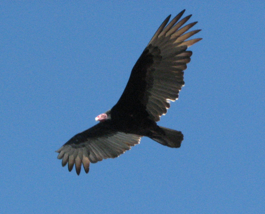
As we walked, Turkey Vultures swooped low over our heads. Known formally as Cathartes aura, these large birds are found throughout the Americas, the most widespread of the New World vultures. The Turkey Vulture consumes no live prey, being exclusively a carrion feeder. It possesses an excellent sense of sight and smell with which to find dead animals. While the body is relatively light (1.4 kg or 3.1 lbs) the wingspan is wide, ranging up to 183 cm or 72 inches. 


Thousands of coconut palms line the beach, their fronds gently swaying in the ocean breeze. Mexico's coconut palms, at least those on the West Coast, probably originated from coconuts drifting over from Polynesia. In any case, they were well established by the time Columbus arrived in the Western Hemisphere in 1492. The trees are cultivated in massive groves all along the coast. The coconut palm is an extraordinary plant, supplying meat, milk, oil, and a variety of materials for building and craft products. 


Isla de las Chivas sits at the tip of the crescent bay. Isla de las Chivas (Goat Island) used to be a separate island, but Mazatlán authorities built a causeway connecting it to Isla de la Piedra. Stone Island itself is not a true island, but is a peninsula which can be reached by car from the mainland. However, it is less trouble and much more fun to go by ferry. For a map showing both Islas de las Chivas and de las Piedras, click here.


Beachcombing the endless sands of Stone Island. After the first 1/4 mile, there are few man-made structures along the shore. Mile after mile of empty sand beaches fringed by rustling palm groves stretches away into the distance. Am I looking relaxed yet?


The schooner Patricia Belle rocks gently at anchor in Isla de la Piedra's cozy little bay. Athough there are fully equipped marinas to the north, near the Golden Zone, if I were a sailor, I would choose to anchor here. The Patricia Belle is available for tours of the area, if you have the $54 (USD) fare--$18 for kids.


Living his dream. The operator of Patricia Belle came on deck as I was photographing his boat. He looks pretty relaxed, himself. The boat seems to be of an older type, with little of the modern fiberglass and other synthetic materials used on newer sailboats. More beautiful, but harder--and more expensive-- to care for. As someone famously said "a boat is defined as a hole in the water into which you pour money."

Where to find something to eat or drink

Palapas on a grand scale. The initial stretch of beach was lined with palapa restaurants. We stopped in one for lunch. The floor was the bare sand underfoot, and a hammock was strung just behind our table. The fare included a variety of freshly-caught seafood, plus various Mexican dishes and other things like hamburgers and club sandwiches. In front of the restaurants was a line of small palapa umbrellas with lounge chairs underneath.


Quirky decorations covered the bamboo walls of the restaurant. Above, two colorful ceramic lizards appear to explore a piece of driftwood. 


Our waiter flagged us down as we walked by his restaurant. The perfect English spoken by this very amiable young man led us to inquire where he learned it. He grew up in the United States living with his Mexican parents, then decided to move down to Mexico and live on the beach. No doubt his employer makes full use of his English skills. Cruise ships dock just across the narrow channel and groups of passengers visit Stone Island on a regular basis. 


And now for a little tune (or two?). As always in Mexico, we encountered a group of wandering musicians. Since the day we visited was very slow for business, we took pity and ordered up a song. They played quite beautifully and were glad to pose for picture with Carole.

Whatever is there to do?

Roaming vendors also stopped at our table periodically. Many folks like to shop. Lolling in your chair, sipping your margarita, as the merchandise is brought to you is a pleasant, and very laid-back way to do it. Occasionally, I hear people gripe about the ubiquitous Mexican vendors in resorts. We have always found that a polite "no, gracias" sends them on their way, if we are not interested. We treat them with respect because they work very hard for very little.


There were a variety of modes of transportation available. I have read occasional reviews of Stone Island that claimed the horses are starving and mistreated. None of the ones above looked in bad shape, and I didn't see any that I wouldn't have rented, had I been inclined. Not that there aren't mistreated animals out there. We just didn't see any.


For those wanting a bit more speed. Vendors rent both motorcycles and ATVs. If I had been ambitious to explore the far reaches of the beach, this would have been the way.


And then there are the "banana boats". These are long inflated tubes with handles along the top. They come in various sizes and are towed by a boat. Above, two women are launched into the surf by the vendor. They appear to be grasping the handles for dear life.


And they're off! A banana boat speeds across the bay with its passengers clinging on as waves and the speedboat's wake buffet them. In the foreground, two children pause in their beachcombing to watch the show.


There is always the simple pleasure of digging in the sand. A toddler hugely enjoyed herself making holes as her mother looked on. She was so engrossed in her excavations that she never looked up while I took several pictures. Overall, we found the beach very clean, considering the amount of use it gets.


And, for the complete slug, there are always the lounge chairs under the umbrellas. As I grew sleepy in the warm afternoon sun, this particular activity looked increasingly appealing. 

The end of the day

Patriotic pelicans. As the day waned, we caught the ferry to mainland Mazatlán. Back in the small fishing harbor, I noticed this flock of brown pelicans hanging about under a Mexican flag flying over  one of the boats. I couldn't resist a photo.


Yet another spectacular sunset, as we finished our last day in Mazatlán. Intense bands of reddish-orange stripe the sky above two cruise ships setting out on a night-time voyage to another exotic seaport.

This completes my 6th and last post of my Mazatlán series. I hope you have enjoyed it, particularly those of you who have been happily frolicking in the snowdrifts up north. If you would like to leave a comment, please do so in the Comments section below or by return email. 

If you leave a question in the comments section PLEASE leave your email address so that I can respond.

Hasta luego, Jim