Saturday, January 29, 2011

Mazatlán Part 1: Crescent beaches & rocky shores

La Sirena searches the coast, possibly looking for her lover. La Sirena (The Siren) is also known as Reina de los Mares (Queen of the Seas). Beside the lovely mermaid stands a small cupid figure, pointing toward the cliffs. Both of them are perched on a rocky outcrop along the Olas Altas (High Waves) section of Mazatlán. Carole and I visited Mazatlán for a week in mid-January. Mazatlán, in some ways, was very different from what I expected. My impressions before visiting were that it would be one long sandy beach with hot, humid days and balmy nights. Instead, we found a series of beaches separated by high cliffs and jagged, rocky shore. The weather was chilly in the mornings and evenings, but warmed up to 23C (75F) during the afternoon. Fog gave the mornings an extra chill, and didn't burn off until noon or later. While I tend to like what I call "San Francisco weather", Carole was looking for "beach weather" and she was a little disappointed in this aspect of the place. We were definitely glad that we'd brought warm clothes as well as shorts and t-shirts. Whether this was unusual weather for January in Mazatlán we have yet to determine. Other winter visitors should take note. For a chart showing average year-round temperatures in Mazatlán, click here.


Two steep hills bracket Olas Altas beach. This photo was taken from Cerro de la Neveria (Icebox Hill), looking south toward Cerro del Vigia (Watchtower Hill). Beyond Cerro del Vigia is the conical peak known as El Faro. A lighthouse perches on top of El Faro to guide ships and fishing boats into the inner harbor. Playa Olas Altas is the beach closest to El Centro, the wonderful "old town" section. El Centro occupies most of a thumb-like peninsula at the south end of Mazatlán bounded by the Pacific Ocean on the west, the ship channel on the south, and the inner harbor estuary on the east. The tip of the thumb is comprised of Cerro del Vigia and El Faro, connected to each other by a narrow causeway. For a map showing all these areas in relation to one another, click here. For a Google map showing Mazatlán in relation to the rest of Mexico, click here.


The Mazatlán Malecon stretches north, all the way from Olas Altas to the Zona Dorada. A malecon is a beachfront walkway. This one is wide, decorated with wonderful sculptures, and lined with cliffs, rocky points and golden beaches. It is also amazingly long, stretching northward 11.2K (7 mi.) from Cerro Vigia to the Zona Dorada (Golden Zone). The view above is from our hotel balcony, north toward Cerro de la Neveria, from which I took the previous photo. The two hills at either end of Playa Olas Altas are quite steep, with sheer cliffs extending down to the rocky shore. They give Olas Altas a cozy, secluded feeling, separating it a bit from the glitzy hustle and bustle of the beaches to the north. Icebox Hill got its name from caves where 19th Century Mazatlecos stored ice for refrigeration. Since those days, Cerro de la Neveria has acquired several tiers of large, expensive homes perched on the cliff tops.


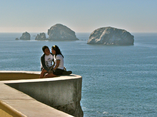
One of many modes of transportation along the malecon. A young girl, bathed in the rosy glow of sunset, skates to the tune on her ipod. At almost any time from dawn to well after dark, the malecon teems with skaters, skate-boarders, bicyclists, joggers, or those just out for a stroll. In many places, the architects used natural outcrops to design nooks and lookout points so that visitors could enjoy the spectacular scenery, and lovers snuggle as they watch the sunsets.


Our hotel, La Siesta, faces the ocean across the malecon and Playa Olas Altas. La Siesta is an old hotel, popular with US movie stars like John Wayne and Tyrone Power in the 1950s-60s. It fell on hard times after the Golden Zone hotel district was developed to the north. In recent years, it was upgraded and some work is still continuing. While not fancy, La Siesta possesses all the normal attributes of a hotel, and everything worked properly while we were there. The room price ($48/night) was modest for January in Mazatlán. In addition to a stunning ocean view, the hotel has a travel agency on the first floor, and the Shrimp Bucket restaurant occupies the north end. The Shrimp Bucket is an old and very popular local seafood restaurant and serves excellent food at reasonable prices.


A room with a view. La Siesta provided Carole with an ocean view room for only the second time in her life, and she was very excited by the prospect. Above, you can see our balcony on the 3rd floor directly over the main entrance. The guest with arms extended was apparently embracing the prospect of everlasting glory, enshrinement in my blog. Seconds after I snapped the photo, he mounted his motorcycle and was gone. From our balcony, we could enjoy the gorgeous, golden sunsets, and later drift off to sleep listening to the rhythmic roar of the breakers below.


Alfredo, and his trusty pulmonia. These odd little vehicles, distant relatives to golf carts, provide much of the transportation in Mazatlán. The pulmonias wear a VW emblem, and the engine sounds like my old bug, but the body is unique to Mazatlán. They are inexpensive, somewhere in price between a bus and a taxi. They are also a bit airy, so I advise a jacket or sweater if the day is cool. Alfredo was a lively young guy who took us on a tour of El Centro and up to the Golden Zone. He spoke a smattering of English and, along with our slowly improving Spanish, we communicated just fine. He was very understanding about my frequent appeals for photo stops. You can hardly walk a dozen steps anywhere in El Centro or along the malecon without one of these pulmonias veering over so the driver can ask if you want a ride. One tip: make sure you negotiate a price before you get on board. If you don't like the price, there'll be another pulmonia along in a couple of minutes--or sooner!


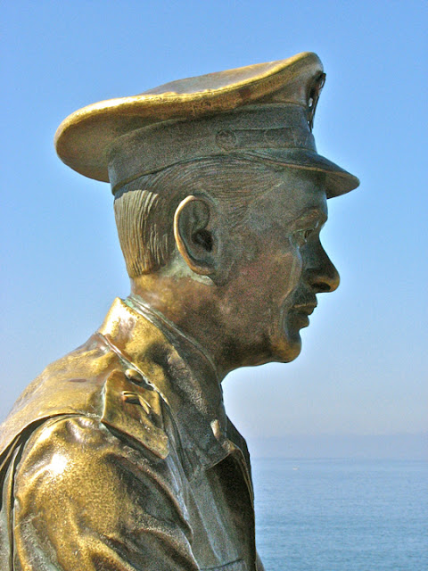
La Mujer Mazatleca was created for the women of Mazatlán. The bronze statue was smelted in Mexico City to celebrate the women of Mazaltlán, locally reputed to be the most beautiful in the world (a designation I suspect may be claimed by a few other places). Gabriel Ruis, a composer from Jalisco, unveiled it. He is famous for writing a number of songs celebrating this coastal city, including "Mazatlán", "Nights of Mazatlán", and "Secret from Mazatlán." Although this photo was taken mid-day, the fog we encountered nearly every morning created a misty background to the statue.


Beautiful to view, but perilous for sailors.  Below steep cliffs, rocky outcrops thrust into a roiling, foaming sea. It is the nightmare of sailors to encounter something like this on a dark, foggy night.


Pedro Infante, Mexican singer and movie star, was born in Mazatlán. Pedro Infante is somewhat of a cross between Elvis Presley and James Dean in Mexican culture. Born in Mazatlán in 1917, he studied music and became proficient in a variety of instruments as well as with vocals. He cut his first record in 1943, the same year that he appeared as an extra in his first film. Infante became a wildly popular star in both arenas, recording 350 songs and acting in 60 movies before his death in 1957. The statue above is one of four commemorating Pedro Infante. The motorcycle in the statue references his role in the movie "A Toda Máquina" (All Machine).


Infante died tragically at the height of his fame and popularity, not unlike Elvis and Dean. He was a private pilot and crashed on April 15, 1957, near Mérida, while flying a converted WWII B-24 bomber on a trip from the Yucatan to Mexico City. Among Mexico's new urban working class of the 1940s, Infante was a hero for his portrayals of a working class man in a trilogy of films called "We the Poor," "You the Rich," and "Pepe the Bull." He also played many roles as a charro, the idealized cowboy of rural Mexico, popular both with the rural poor and the recently-rural urban workers. Like the actor James Dean, he died tragically in an accident. Like singer/actor Elvis Presley, a cult developed that asserted he was not dead but alive and in hiding. I was particularly interested in his statue. Notice how every line and crease of his clothing, body and even of the mototcycle is shown. It is almost as if the sculptor dipped Infante in bronze while astride his bike, as people used to do with baby shoes.


One of many homes perched atop a rocky cliff, facing the open ocean. When a storm hits the coast here, living in this house must be pretty dramatic with huge waves smashing against the cliffs below. Notice the three islands in the distance. From left to right they are Isla de Chivos (Goats), Isla de Venados (Deer), and Isla de Pájaros (Birds). Tour boats stop by Isla de Venados, the largest of the three. I'm not sure there are deer on the island, but the snorkling and diving is reported to be excellent.


Lovers chat on an nook high above the crashing breakers. The several large rocks just off the coast near Cerro Vigia are called Piedras Blancas (White Rocks). The white color comes in part from the rocks themselves, but also from the guano of innumerable birds of the various species that nest there. One of the smaller rocks is a favorite gathering place for sea lions, also a popular stop for the tour boats.


Playa Norte curves from Cerro de la Neveria around the bay to the Zona Dorada. The photo was taken from the top of Cerro de la Neveria looking north. This is probably the longest unbroken stretch of beach in central Mazatlán. The Zona Dorada, or Golden Zone, is at the far left of the beach seen above.


And what would a beach be without pretty girls...? These three Mexican girls were shopping for a secluded stretch of beach. They gave me their best coquettish smiles when they noticed my camera.


Playa Tiburón comprises the first stretch of the much larger Playa Norte. Tiburón is Spanish for shark. The name is appropriate because this is the beach where the local fishermen pull up their boats to clean their catch, and to patch and repair their boats and nets.


A fisherman cleans his catch under the watchful eye of a would-be assistant. When I snapped this shot, I didn't even notice the pelican at first. I am always amused by the friendly relationship between these two species who both depend upon fishing for their livelihood. The pelicans are not the least bit shy as they intently wait for any tidbit offered by the fisherman, or perhaps any he has neglected to safeguard.


Another of the malecon's unusual statues. I have never before seen a statue dedicated to a mode of transportation. Even Pedro Infante's statue was about him rather than his motorcycle. However, pulmonias are such a fixture of Mazatlán life that I suppose it is appropriate that they be memorialized. Like Infante and his motorcycle, every detail of the pulmonia is included. The fog was really rolling in at this point, hence the almost white background.


Xanadu on the beach. This was the beginning of the Golden Zone. Playa Norte ends here, along with the malecon. The structure on the point of land looked at first like some fantastic version of a Mormon Temple, but it turned out to be a combination restaurant and disco-bar. I nick-named it after Samuel Coleridge's poem which begins "In Xanadu did Kubla Khan a stately pleasure-dome decree..."


The view down Playa Norte from the Zona Dorada, looking south. Having previously shown quite a few cliffs and rocky shores, I didn't want to leave the wrong impression of Mazatlán. There is, indeed, a bit of beach here. Cerro Neveria can be seen at the upper right.


A show to remember. Alfredo, our pulmonia driver, dropped us off at this point near the bottom of the Cerro Neveria cliffs so that we could enjoy the stroll back to our hotel. I was a bit puzzled at why someone would build such a platform on the top of this natural rock tower. As people gathered along the malecon, I realized something was about to happen.


Diver at the "moment of truth." Some young men climbed the steps of the tower, skins glistening as seawater streamed from their bodies. "Oh my god," I said to my self, "they're actually going to dive into that narrow slot of water!" The drop is at least 12.2 meters (40 ft). Even as I said it, the diver above leaned forward into his launch. He would have to dive pretty far out to miss the jagged rocks immediately below. Who knew what might lie just under the surface of the foaming seawater below?


No turning back. The young diver gracefully floated down and cut cleanly into the sea. After a moment, he emerged and began his long climb back to the top of the tower. We were well on our way back to the hotel before we realized that we should have stuck around to offer a tip for his performance. We'll tip the divers nicely when we return to this spot. The show was pretty spectacular and definitely worth seeing.


A man and his small son enjoy the late afternoon sun along Playa Olas Altas. The afternoon was all golden light and sparkling sea as we watched from our balcony. There was always something to catch our eyes as we leaned back in our chairs in comfortable tiredness.


A Mazatlán sunset, one of many we would see on this adventure. As the sun approaches the horizon, fishing boats head back to Playa Tiburón for the night. Every sunset on our trip was a little different, but every one was spectacular in its own right.

This concludes Part 1 of my multi-part series on Mazatlán. In Part 2, I will show you what we found as we strolled around El Centro and its Plaza Machado. I always appreciate feedback. If you'd like to leave a comment, you can do so either in the Comments section below, or by emailing me directly. If you leave a question in the Comments section, PLEASE leave your email so that I may respond.

Hasta luego, Jim


Sunday, January 23, 2011

Hiking Leonera Canyon

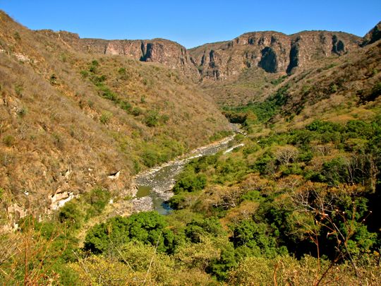
El Rio Verde flows peacefully below the steep cliffs of Barranca de Leonera. Last November, I read an intriguing story by John Pint in the Guadalajara Reporter (the local English-language newspaper). In it he described a ruggedly spectacular canyon to the north of Guadalajara. It seems I was not alone in my interest, because the next time my weekly hiking group assembled at Doñas Donuts in Ajijic to prepare for our usual trek into the mountains, everyone was talking about Pint's story. We quickly agreed upon a date and began alerting others to this hiking opportunity. On November 30, guided by Pint's excellent directions, 4 carloads of us departed Ajijic for the 2-hour drive to the canyon country north of Guadalajara.

The trailhead begins with a scenic mirador. The mirador, or overlook, is adorned with a spread-armed statue of Jesus and a tiny shrine. The cliffs drop away immediately in front of the stone wall, providing a sweeping view of the canyon. The mirador is situated a few kilometers northwest of the small town of Acatic, which can be reached off either the #80 cuota, or the Libramiento road that parallels it. Although we had brought high-clearance vehicles to ensure we could get through on the dirt road leading up to the mirador, a street vehicle could have made it just fine. At the end of this posting, I will print John Pint's specific directions for those who might like to visit the canyon. For a Google map of the area, click here.

A snake greeted us as we arrived at the mirador. This harmless green tree-snake had somehow wandered onto the flagstone patio of the mirador. Unfortunately, some unknown person had apparently stepped on its neck, injuring the beautiful little creature. After taking a photo or two, we carefully moved him to the trees outside the mirador where he would have some chance of survival. A widespread fear of snakes sometimes leads people to act with mindless cruelty.

The view from the mirador. A brilliant, almost cloudless day provided an awesome view. You can just make out the line of el Rio Verde (Green River) at the bottom of the canyon. The terrain moves down through several ecological zones, from dry, semi-desert at the canyon rim, to riparian forest at the bottom.

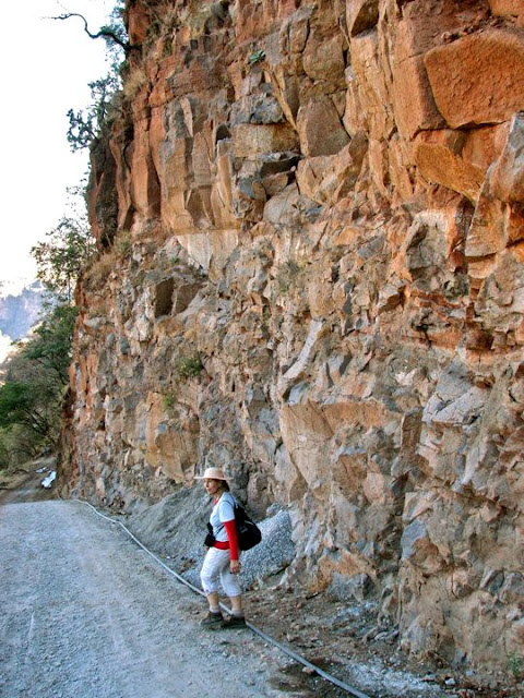
Diana under the cliffs. A Canadian, Diana is an avid hiker. She stands under the vertical cliff that drops down to the cobblestone road presently under construction. The locals clearly see the Barranca de Leonera as a tourist attraction, and have several projects under way. I was glad to be able to visit the area while it still retains its serene atmosphere. The line at Diana's feet brings water to mix the concrete at the construction site further down the trail.


A break for desayuno. We encountered these friendly construction workers part way down the canyon trail. They were gathered around a small fire built to cook desayuno, the morning meal, and cheerfully agreed to a photo. Mexicans will typically eat 4 times in a day. When they get up, they may have a cup of coffee and a sweet roll or a piece of fruit. At about 10 AM, they break for a more substantial meal which may include tacos or empañadas. At around 2 PM they eat comida, the main meal of the day, after which there may be a short siesta. In the late evening, perhaps 9 or 10 PM, they eat cena another light meal. The Mexican schedule of eating may be healthier than the typical north-of-the-border method which involves a heavy meal in the evening, when the body has slowed down, and can lead to fat retention and digestion problems.


The inner canyon. The outer canyon walls drop steeply to a sloping, wooded plateau. The plateau falls off sharply in places to form an inner gorge, as seen above.


Lovely butterfly poses for our cameras. I originally thought this butterfly might be a Monarch but it is not. It graciously remained motionless for the several minutes that it took for all of us to get our shots. Butterflies can often be difficult to photograph because they tend to move around a lot, often in unexpected directions.

As we approached the canyon bottom, the reason for el Rio Verde's name became evident. The water took on the green coloring of the hillsides. The steep cliffs of the outer canyon can be seen in the distance. Although lengthy, the trail was never really difficult. It amounted to a reasonably smooth dirt road for most of the way. Generally, for aesthetic reasons, I don't care to hike on dirt roads. However, this one provided such continuously outstanding views that I was willing to make an exception.

Tilandsia, a member of the Bromiliad family. We often find these odd plants growing on the branches of trees in the wild or on power lines in town. They gather all the water and nutrients they need from the air. Bromiliads have an amazing capacity to store water. Studies have shown that 175,000 bromiliads sometimes can be found in one hectare (2.5 acres) of forest. That many bromiliads can sequester 50,000 liters (13,000 gallons) of water.

Closeup of a flowering Tilandsia. Bromiliads are a huge family which includes pineapples. Tillandsia is a genus within the family, and has at least 500 species. They are very widespread, from Virginia to Argentina. They can be found everywhere from the seashore to the desert. The Mayas, Aztecs, and Incas all used bromiliads for food, fibre and ceremonial purposes. They do have roots, but those are used more for gripping tree branches and telephone lines than for gathering nutrients.

A banana grove indicates a settled area is near. As we wound down the dirt road, the vegetation became more lush, even tropical. These banana trees grow in the partial shade of deciduous trees that grow toward the bottom of the canyon. Bananas may be the first fruit farmed by humans. They originated in Malaysia from two inedible species which were crossed to form a sterile species that produced edible fruit. The plant was propagated by using shoots from its base. The first edible bananas may have been produced about 2000 BC. They were first brought to the Western Hemisphere by the Spanish Friar Tomas de Berlanga in 1502, and made their way to Mexico after the Conquest.

Evidence of civilization deep in the canyon. As we moved into the welcome shade of trees near the canyon bottom, we began to encounter the adobe ruins of a tiny pueblo. I have always liked old adobe structures because of their innate beauty as well as the antiquity of this method of construction. Filtered streaks of morning sunlight created a warm glow across the rough, rust-colored surface of the old wall above. It was a photograph I couldn't resist.

An arched doorway leads into the vestibule of a small house just off the road. The slanting morning sun brought out a  delicate yellow in this old ruined structure. Adobe is one of the oldest building materials in human history. It is made of easily obtained materials: sand, clay, water, and some kind of fibrous material, often straw. In spite of the fact that they are made essentially of earth, adobe buildings are extremely durable and account for some of the oldest structures on earth. The bible speaks of the Hebrews making adobe brick for the Egyptian pharoah. Indigenous people of the Western Hemisphere were making adobe for thousands of years before the Conquest, but the Spanish introduced them to the method of forming it into bricks. The Spanish themselves had been using adobe since at least the Late Bronze Age.

A small church indicated that the pueblo was not completely abandoned. Rural Mexicans are a religious people and churches are found everywhere among them. This tiny old church was perhaps 5 meters across (15 ft) and 10 meters long (30 ft). Gerry, a Canadian, watches from a distance as Mike, an American from Alabama, looks for a point of entry. Above the church you can see power lines, a fairly recent addition to the old canyon community.


Interior of the little church. Mike's efforts were successful, and we were able to briefly visit the interior of the old church. Everything was very rustic, but clearly the local people cared a great deal about their little chapel. The walls and altar contained fresh flowers, and a picture of the Virgin of Guadalupe--patron of Mexico's poor and indigenous people--held the place of honor. As always, a Mexican flag hangs in close proximity to the Virgin. The Virgin of Guadalupe is not only a religious but a political symbol in Mexico. After taking a few photos, we respectfully withdrew.

Hikers are dwarfed by huge Mexican Fencepost cactus. The cactus above is formally named Pachycereus marginatus, but is commonly referred to as Mexican Fence Post. It can grow up to 7 meters (20 ft) tall. Fence Post cactus grows widely in the wild, but is also cultivated as a decorative plant, as well as being used as a very effective fence along the edge of fields (hence the name). At this point in the hike we had almost reached the river. The group above went in search of some waterfalls John Pint had mentioned in his article.

Christopher tests the water. You may remember my friend Christopher from my postings on Zacatlán and our more recent visit to Tula. To our astonishment, we found a small resort at the bottom of the canyon. It included a large swimming pool, filled by water cascading from the pipe seen above. A canopy-shaded area is available for parties and other events, as well as a rudimentary bar. The owner of the establishment invited us to sit in the shade and sample lemons from the trees grown just behind the wall seen above. We were a little dubious about the offer until we tasted the lemons. Juicy and amazingly sweet, the lemons hit the spot after our long dusty hike down the canyon road. I have never encountered anything quite like the lemons of Leonera Canyon.


A short scramble over riverside boulders led us to this quiet stream. I imagine that in wet weather, the Rio Verde gorge becomes a roaring torrent. However, on the warm, sunny, fall day we visited, the canyon was serene; only the chirping of birds disturbed the quiet. From this point, you are looking upstream to the north.

And speaking of birds... I noticed a movement far up the stream. Using my telephoto, I captured this Great Blue Heron fishing from a rock in the middle of Rio Verde. Great Blue Herons are common to my former home in Oregon. In fact, there is even a micro-brewed beer named for them and sold in Portland. Great Blue Herons are the largest species of heron in North America. They can be found everywhere from Alaska to South America.

Looking downstream to the south. The inner part of Leonera Canyon widens a bit here, before narrowing between the steep inner-gorge cliffs seen in picture #7 above. El Rio Verde contains long deep pools that look like they'd make for good swimming. Since it was a bit late in the year, and I had no bathing suit (we were in a mixed party), I decided against giving it a try. Perhaps some other time.

Beginning the long return trek. Three of our party hike along the road as it wanders through a beautiful grove of shady trees. The waning afternoon required us to begin our hike out of the canyon. We never did find Pint's waterfalls. We later speculated that they might be up a side canyon from a trail we had seen branching off the road. We'll save them for a return trip.

Late afternoon sun begins to stretch shadows across the canyon. In the center of the photo is a large oval area with light colored vegetation. This was a cleared area of pasture land on the intermediate plateau. Looking closely, we could just see some stone walls and a couple of tiny sheds. In the distance, the canyon winds off toward the north. While we saw a great deal from the various viewpoints along the way, that unexplored (by us, anyway) and mysterious inner canyon still tweaked my imagination. At this point, I was about 1/2 way up to the top of the canyon.

My American friend Tom strolls up one of a long series of switchbacks. While the hike down was easy enough, the hike back felt much longer. None of it was really steep, but it went on and on in the hot afternoon sun. That is the penalty of hiking down into a canyon, as opposed to up into the mountains. Just at the time when you are tired and the sun is highest, you must go up rather than down. No one complained (much), however. The day had been luminous with late fall light, the views had been wonderful, and we had found a new hiking playground.

How to get there. By John Pint

"Near Tonalá (on the eastern side of Guadalajara) take the Tollroad-Autopista heading for Mexico City. Fifteen minutes later, the road divides. Take the left fork (signposted Zapotlanejo). Again the road divides and again you take the left fork, this time for Tepatitlán. You should now be on Autopista 80D, heading northeast. A half hour later take the Acatic exit. As you enter the town, set your trip odometer to zero at the Pemex gas station. Drive straight north through Acatic. Some zig-zaging is necessary due to one way streets, but you should eventually exit the town on Calle General Andrés Figueroa and find yourself on a half asphalted road well sprinkled with potholes. 6.6 kilometers from the gas station you'll come to a fork. Take the left branch and drive northwest. At 7.2 kilometers on the odometer, you'll come to another fork. Keep right and continue going northwest. At eight kilometers you'll arrive at the Lookout Point (mirador), which has a parking lot. Here you can begin your hike along a cobblestone road heading north. Driving time from the eastern edge of Guadalajara to La Leonera Mirador and parking spot: about one hour."

This completes my posting on our Leonera Canyon hike. I always appreciate feedback, so if you'd like to comment, you can do so either in the Comments section below, or by emailing me directly. If you leave a question in the Comments section PLEASE leave your email address so that I may respond.

Hasta luego, Jim

Wednesday, January 12, 2011

Toltecs Part 2 of 2: The Ancient art of Tollan and the modern city of Tula

Atlante pequeño in the main Tollan museum. Tollan actually has two museums, at opposite ends of the site, both worth a visit. This small but beautiful atlantean figure was probably used to support an altar in one of the temples atop the pyramids at Tollan. The figure shows a Toltec warrior-noble wearing a cotton vest and a turquoise chest piece. Atlantean figures like this are common to both Tollan and Mayan Chichen Itzá. In this second part of my Toltec series, I will focus on some of the sculpture and other art found at Tollan. Unfortunately, the city has been scoured for loot over many centuries, probably beginning with the migration of the Aztecs through the area on their way to their ultimate home in the Valley of Mexico. The Aztecs were so taken with the culture of the Toltecs that they returned again and again to loot the site in order to decorate their capital Tenochitlan. Later in this posting, I will show you a bit of modern Tula, the Mexican city that grew up around the ruins of Tollan.


Christopher contemplates colossal feet. This statue, located in Tollan's second and smaller museum, must have been huge when it towered over the mere mortals who inhabited Tollan. My friend and traveling companion Christopher stands only a little under 1.82 meters (6 ft.) in height, yet he only comes up to the knees of this colossus. As with most of the other Toltec statues I have seen, this one stands erect and at rigid attention, in a definite military posture. Militarism was one of the aspects of Toltec culture most admired by the Aztecs, who had imperial ambitions of their own. Notice the colossus' high-backed sandals. I have seen this same style sold in leather stores around Mexico. The more things change...


A chac mool waits for its next victim. If there is one kind of sculpture that epitomizes Toltec art, it is the chac mool. Although there are some variations, the overwhelming majority of chac mools that I have seen are virtually identical to the one above. The typical figure rests on its back, with knees bent. The head is turned to the side in a watchful stance. The arms support a shallow tray or bowl on the figure's stomach. An upper-arm bracelet is used as a knife-holder. The knife and the tray are significant, because the most likely function of a chac mool was to receive the still-warm and dripping heart of a sacrificial victim. A chac mool identical to the one above rests at the top of Chichen Itzá's Temple of the Warriors, and another was found in that Maya city's famous El Castillo pyramid. Although the two cities were worlds apart both geographically and culturally, they had a strong but still mysterious connection (see Part 1 of this series).

Skeleton from the main Tollan museum. Found at Tollan, this skeleton may have been from someone whose heart once graced the tray of the chac mool in the previous picture. Notice the bowl in which the skull rested when the skeleton was unearthed.

Intricate relief carvings cover a column atop the Temple of the Warriors. Unlike the more blood-thirsty carvings found on the Coatepantli, or Wall of Snakes, at the back of the Temple of Warriors, the carvings on this column are more pacific, with flowering plant-life and some abstract designs.

Censer in the main museum. A censer is a device for burning copal incense during religious and other ceremonies. Censers are usually decorated, often with faces such as the wide-eyed, open-mouthed figure on this censer.

Jade plaque from main museum at Tollan. The figure, which wears a rather sour expression, is naked except for short pants, a necklace, and some sort of headpiece which might also be curled hair. Unlike most of the Toltec art I saw at Tollan, which was monumental and often related to death, this small piece (about 10 cm x 5 cm or 8" x 4") seemed more human-scale to me. I am not sure of the round object he holds in his hands, but it could be one of the hard rubber balls used in the ball games at Tollan's two large courts.


Jaguar chac mool snarls at Tollan's smaller museum. This chac mool differs from the usual style, in that it doesn't represent a human figure. There is a similar, but much larger jaguar chac mool in the Aztec section of the Museum of Anthropology in Mexico City. Perhaps the Aztec creators of that statue drew inspiration from this earlier Toltec version.


Jade necklace from the main museum. Again, I felt oddly comforted to find an example of simple, personal decoration. The wave of Chichimec invaders from the north who destroyed Tollan around 1168 AD probably looted much material like this. Even more was taken by the Aztecs who were also Chichimec nomads at the time they passed through around 1350 AD. "Chichimec" is actually an Aztec term for hunter-gatherer nomads from the northern deserts. It is not the name of a specific ethnic group, but rather means something akin to "uncivilized barbarian." In other words, any group which is not settled and urbanized.

Stone head with braided hairstyle resembling modern-day "corn-rows." The Toltecs themselves probably originated as Chichimecs who moved down from the northern wastes into the chaotic aftermath of the fall of the Teotihuacan Empire around 650 AD. They settled in the area around modern-day Tula about 700 AD at a smaller site called Tollan Chica and then moved to the present site of Tollan Grande about 900 AD. Tollan continued to grow as it became the seat of their empire. Just as the Aztecs copied elements of Toltec culture and architecture, the Toltecs themselves adopted many aspects of the still-earlier Teotihuacan civilization, including the pyramid and the plumed serpent god. After Tollan fell and the Toltecs disappeared, the Aztecs adopted the plumed serpent and called it Quetzalcoatl. For a timeline placing all these Meso-american civilizations in chronological context, click here.


Helmeted standard bearer.  These small figures are usually found on the stairs of temples and pyramids. The clasped hands were intended to grasp a pole from which a banner waved. The banners are thought to have carried religious or military symbols. An almost identical standard bearer stands atop a plumed serpent on the Temple of Warriors at Chichen Itzá, another example of the many mysterious connections between the two ancient cities.

The modern city of Tula

Tula de Allende is a vibrant, prosperous, small city. Although Christopher and I were primarily focused on the ruins of Tollan when we passed through on our way to Zacatlán, we saw enough of Tula to decide on an overnight visit upon our return through the area. Tula is located in Hidalgo State, southeast of Querétaro and about 92 kilometers (57 mi.) north of Mexico City. The city lies a few miles to the east of the #57 cuota near where the new Arco Norte cuota begins its northern bypass of the Mexican capital. Above, you see Tula's main plaza, busy with late afternoon activity. In the distance is the Tula Cathedral, looking like a medieval castle. While there are over 93,000 people who live in the Tula municipality (roughly comparable to a US county) there are only about 28,000 in the city itself.  For information about visiting Tula, click here. For a map of Tula and the surrounding area, click here.

Catedral de Tula de Allende. In 1529, the first friars arrived in the area to evangelize the indigenous people, about 7 years after the Aztec Empire fell to Hernán Cortéz and his conquistadores. Fray Alonso de Rangel quickly learned the Nahuatl language of the Aztecs and also that of the Otomi people who were living around the ruins of Tollan. Shortly after he arrived, he began to build the first chapel. Construction on the Cathedral began in 1543 and concluded in 1554. The Renaissance-style architecture is a very austere but beautiful, constructed with pink and gray cantera stone that glows in the afternoon sun. Fray Antonio de San Juan was the architect, with some assistance from Fray Juan de Alamenda.

The Cathedral looms above Tula like a medieval castle. Many of the monastery-churches established by the Franciscans and Augustinians are now called iglesias fortalezas (fortress churches) because they have similar appearances. Most were built within a few decades of the Conquest when revolts were common, as well as raids from the north by the Chichimecs. The high walls, battlements with turrets, and narrow windows created a formidable defensive position to which the local population could flee, if necessary.

International solidarity. While wandering through the plaza, I came upon a demonstration by the Mexican Electrical Workers Union. The union members were holding a hunger strike to protest their arbitrary (and possibly illegal) mass firing by the Mexican government. As a retired union organizer I was immediately sympathetic to their struggle. My Spanish was too limited to determine all of the details, but it sounded very similar to some of the strikes I had helped organize over the years. My Mexican union brother was glad to pose for a photo in front of the hunger-strike's tent-headquarters.


Hotel Real Catedral. We had no reservations, but just blew into town and looked for a place to stay. The local Holiday Inn seemed a bit expensive, but Hotel Real Catedral worked out perfectly. The site couldn't be better, in the center of town, across the street from the Cathedral, and on the edge of the plaza, and--very important--it has off-street parking. The rooms were clean, modern, and reasonably priced at $57.00 (USD) for a double. Split between us, that made it quite inexpensive. The beds were comfortable and everything worked, including the air conditioning on that particularly hot day. We even found a nice Continental breakfast waiting the next morning. After our long drive from Zacatlán, we were ready for a little comfort. For a list of other hotels in Tula, click here.

Our room secured, we went in search of dinner. We found a little place with a balcony overlooking the plaza. It was a balmy evening, so we enjoyed ourselves as lovers cuddled on the benches all over the park, and a watchful cop peddled around on a bicycle. The whole place seemed rather idyllic.

Young students out for a stroll. Love was apparently in the air. There were young couples everywhere, including this pair who strolled by our balcony and gave us a grin when they saw our cameras. I'm looking forward to stopping by Tula again sometime this year when Carole and I travel to Puebla. Both the ruins and the town itself make it well worth another visit.

This concludes Part 2 of my 2-part series on the Toltecs. I always appreciate comments and feedback. If you'd like to leave a note, you can do so in the Comments section below, or email me directly. If you leave a question in the Comments section PLEASE leave your email address so that I can respond.

Hasta luego, Jim