Showing posts with label Yucatan. Show all posts

Thursday, February 13, 2025

Valladolid Adventures Part 1 of 22: A jewel among Yucatan's treasures

Statue on the central fountain of Parque Principal Francisco Cantón Rosado. She is called "La Mestiza" (meaning mixed Spanish and Maya) and wears an embroidered huipil, the traditional garb women in Yucatan. Manuel Cachón sculpted the statue in 1924. His original work was replaced for a time by a monument to the heroes of June 4, 1910, who ignited the Mexican Revolution. Eventually, that monument was itself replaced by this replica of the original. La Mestiza's smile epitomizes the friendly, laid-back local attitude.

In Part 1 of my Valladolid Adventures series, I will do something a little different from my past practices. I intend to briefly highlight some--but not all by far--of the fascinating things to see and do in this small city in central Yucatan. Each of these places will be covered in some depth in future parts of the series. My future postings will also cover nearby places we visited on day-trips outside Valladolid. These will include Maya sites like Ek Balam, Cobá, and Muyil, and the great colonial-era monastery at Izamal. If the Yucatan Peninsula is a treasure chest of experiences, Valladolid shines as one of the brightest jewels.

Overview

Google map of our route from Mérida to Valladolid. In January of 2017, we flew into Mérida from Guadalajara, and rented a car at the airport. We stayed the night at a nearby hotel so we would be fresh for our drive the next morning. It is a pretty straight-forward route. You head south on the highway from the airport and look for signs for the Mérida Periferico and Cancun. Once on the Periferico, you travel for 19 km (11.8 mi) or 20 minutes. Turn right at the exit for Cancun, onto the autopista Highway 180. (Alternatively, you could fly into Cancun and drive from there to Valladolid, about the same distance.)

The Highway 180 autopista (high-speed toll road) should be in excellent condition. Follow 180 for about 2 hours until you come to the exit on the right for Valladolid. From the exit, drive 5.6 km (3.5 mi) south along Highway 295 to Parque Principal in the center of the city. We stayed at Hotel Mesón Marquis, which faces the Parque's north side. There are other good hotels in Valladolid, but we chose this one because it was central and within walking distance of nearly everything we wanted to see. For a Google interactive map, click here.

Parque Principal Francisco Cantón Rosado

The fountain of La Mestiza is surrounded by a circle of benches. Walkways radiate out from the path around the circle. Through the trees on the south side of the Parque, you can see the bell towers of Templo San Servacio, Valladolid's main church. Although the Parque is generally fairly serene, there was a colorful fiesta during part of our visit, with booths selling a variety of handicrafts. In the next posting of this series, I will give you a taste of this vibrant event.

The Parque Principal stands in an area once covered by a Maya pyramid that was 100 m2 (109.3 yds2). Following the usual Spanish practice, the pyramid was demolished and its materials were used to build the City Hall, mansions for the conquistadors, and an earlier version of the Templo San Servacio, . The space left by the removal of the pyramid became Plaza de Armas, so-named because that was where the colonial militia met to drill. In 1900, the plaza became Parque Principal Francisco Cantón Rosado, named for the Governor of Yucatan who donated the fences surrounding the Parque

Templo San Servacio

The church resembles a fortress because it occasionally functioned as one. Notice the high walls and three vertical gun slits on each tower, placed there to be used during periodic Maya revolts. Since the Maya refused to stay conquered, the Spanish buildings had to be defensible. As mentioned above, the original church was built from materials looted from the pyramid of Zaci. That was the name of the people living in the area when the Spanish arrived. After the conquistador Francisco de Montejo el Sobrino defeated them, he named his new city Valladolid, which was the name of the city that was then capital of Spain. 

As I mentioned, the church above is not the original Templo San Servacio. That structure was demolished in 1705 on the order of the bishop, Don Pedro de los Rios Reyes, "to help erase the stain" of a crime that had been committed on its premises. In a future posting, I will detail how it was that the church came to be rebuilt in its present form. Visitors to my blog may have noticed that I spend a lot of time photographing and talking about religious structures like this one. I am not a religious person myself, but I do admire the artistry and cultural significance of Mexico's colonial heritage, as well as its pre-hispanic heritage. 

Hotel Mesón de Marques

Courtyard and swimming pool of our hotel. I took this shot from the balcony just outside of our room. This hotel was one of the nicest we have stayed at during our time in Mexico. The location of the hotel was ideal for exploring the city on foot. The staff were friendly, efficient, and helpful. One of the best aspects was the restaurant, located around another courtyard, where we ate most of our breakfasts and dinners. The food was delicious, reasonably priced, and the service was excellent. A future posting will cover this very special hotel.

The Méson de Marques (Mansion of the Marquis), was built in the 17th century for a high-level member of the Spanish aristocracy. In colonial times, the most important members of the local community built their homes facing the main plaza of a city, or along streets adjacent to it. The further out you lived, the lower your social status. The indigenous people lived on the outskirts and provided the cooks, maids, gardeners, and other servants of the wealthier classes. All this didn't happen by accident. It was the result of deliberate colonial urban planning dictated by Spanish King Phillip II in the last part of the 16th century. 

Ex-Convento San Bernardino de Siena de Sisal

View of the Ex-Convento from the right. The distant figure in the center is Carole. Construction on this Franciscan ex-convento (now a museum) began in 1552 and was completed in 1560. That's quite a rapid pace for such a large structure. In fact, it is the second largest Franciscan construction in Yucatan, covering 14,121 sq meters (15,442 sq yds). Included in the complex are the church, cloister, chapel, and orchard. The ornate retablo behind the church's main altar is particularly notable. Given the size of the complex, I will probably do more than one posting on it later in this series.

For those who viewed my recent series on the Franciscan convents in the Sierra Gorda, you will recall that the Franciscans played a major role in Mexico during the so-called "Spiritual Conquest". Some of the young Franciscans who worked in the Sierra Gorda ended up in leadership positions in the Yucatan missions later in their lives. That the Yucatan's two largest conventos were both Franciscan shows the significance of the Order's role here. Ex-Convento San Bernardino de Siena is located about 7 blocks southwest of the Parque.
Cenote Zaci

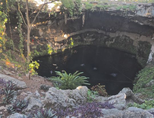
Cenote Zaci is a deep, shady, water-filled pit in the limestone crust of Yucatan. The small floating objects in the water are swimmers. The figure dressed in red by the tree on the left provides a sense of scale. Cenote Zaci is open from 8:30am to 5:30pm with a modest entrance fee of 30 pesos ($1.50 USD). There are changing rooms and restrooms as well as an adjacent restaurant. Lifejackets are also available. Only a few of Yucatan's cenotes are located so conveniently within a town. This one is just 4 blocks northwest of the Parque Principal

Cenotes are found throughout northern Yucatan and were the main water source for the ancient Maya civilizations that developed here. Including Cenote Zaci, Valladolid has at least two cenotes within blocks of where the Zaci pyramid once stood. Most of Yucatan is a flat, porous limestone shelf. Rainwater seeps down into it to form underground pools. The crust over some of these pools eventually erodes and collapses, leaving an open pool. The meteor that struck the coast of Yucatan 60 million years ago not only killed all the dinosaurs but created a series of concentric cracks in the limestone which helped create the cenotes.


Museo Regional San Roques

Ancient Maya stucco mask. The facial features include a rounded, chubby face, thick lips and a flattened nose. These give the mask an uncanny resemblance to those on the great stone Olmec heads found in the State of Veracruz. The Olmec heads were found hundreds of miles away from Valladolid, and their civilization died out at least 1000 years before this mask was made. I therefore found the resemblance very odd. I would be open to hearing from anyone who can enlighten me about this. The mask, along with other Maya artifacts, are displayed in the Museo Regional San Roque, about 1 block east of the Parque Principal. 

The site of the museum has a long and colorful history. It was originally a 4-bed hospital, founded as Hospital del Santo Nombre de Jesus in 1575 by Valladolid Mayor Don Diego Sarmiento de Figueroa. This evolved into the Convento de San Roque and by 1645 the hospital was the best in the province. All this has long since disappeared except for the temple to San Roque. Several historical figures are buried under the museum's courtyard, including those killed in the crime that resulted in the demolishment of the Temple of San Servacio, as well as activists executed at the beginning of the Mexican Revolution.

Iglesia Santa Ana

Iglesia de Santa Ana, seen through one of the triple arches of its front gate. This small 16th century church was originally built for the Maya natives. At that time, all services except mass were conducted in their language. Santa Ana, the church's patron, is said to be the mother of the Virgin Mary. These very early colonial structures represent a world very different from today's modern, bustling Mexico. The structure still functions as a church after 500 years. I very much appreciate the effort Mexicans take to preserve their heritage. A future posting will take a closer look at the church, both inside and out.

Part of the open space in front of the church, called the atrium, later became a neighborhood park. It was in this park that Manuel Antonio Ay was hanged on June 30, 1847. He was an early leader of the Caste War (1847-1915), a great Maya revolt that nearly drove the Spanish out of Yucatan. Today the park contains a monument to Los Heroes Niños (the Child Heroes), commemorating the cadets who died fighting the U.S. forces that had invaded Mexico in 1846. Several young cadets died defending Chapultepec Castle. One of them, rather than surrender, wrapped himself in the Mexican flag and jumped off the high parapet.

Hacienda San Lorenzo & Cenote Oxmán

The casa grande of the hacienda has been transformed into a a hotel. Hacienda San Lorenzo was constructed in 1746. There is very little information available about its early history, some sources suggest that this hacienda may have grown agave for mezcal, a liquor similar to tequila. Distilling these liquors became important in the last half of the 18th century, so production soared. In addition haciendas in this area produced corn, cattle, and sugar. Sisal, a plant native to Yucatan, was also grown at many 19th century haciendas in north central Yucatan. It was used for twine to bale wheat sheaves and for rope to rig ships. 

The hacienda has the advantage of possessing the Oxmán Cenote, one of at least two within Valladolid. This was fortunate for the original hacienda owners because there are no rivers and very little above ground water in northern Yucatan. Lack of water inhibited crop production of any but drought-resistant plants like agave and sisal. The cenote here is very similar in size and shape to Zaci Cenote. Like at Zaci, you can swim here and there were several people in the water when we visited. As you can see above, the casa grande's pool was empty, so the experience of diving into the Oxmán Cenote must have been captivating.

Centro Artesanal Zaci

Zaci's handicrafts center faces the Parque Principal, on its north side. The Centro Artesenal Zaci stands next to Hotel Mesón de Marques on its west side. It was once a the mansion of a conquistador, but it later became part of the Casa Cural (parsonage or priest's house). 

Refurbished in the 19th century, the building housed the Model Central School in 1906 and the Military Exercises Professorship in 1908. The Bolio family owned the property as a private home for a time, but in 1940 it again became a school named after local luminary Delio Moreno Cartón. In 2007, the school was moved and the Valladolid Administration opened the Centro Artesenal Zaci. (Photo from En-Yucatan website)

Casa de los Venados

"Hi! What's up? Come on in and relax!" A scary skeleton, with a somewhat off-putting expression, greeted us when we arrived at Casa de los Venados (House of the Deer). This is the home of Mr. and Mrs. John Venator, who own Mexico's largest private collection of folk art. Over 35 years, they gathered more than 3000 items, including some of the most extraordinary I have yet encountered. After we made the expected donation of $100 pesos ($5.00 USD), our Mexican guide Freddy showed us around the place. Neither the Venators nor Freddy had any problem with the considerable number of photos I took. 

John Venator retired to Yucatan after a career as a CEO of an international trade organization in Chicago. He and his wife looked at various places in both Mérida and Valladolid before buying this 18,000 square foot property. It has become both their home and their private museum. The house was largely in ruins when they purchased it, but they remodeled it over 8 years, first for vacations, then as their retirement home. Casa de los Venados is 1/2 block south of the Parque Principal. They share it with a small terrier who loves to sit on John's lap. Whatever else you decide to see in Valladolid, don't miss a visit to this place!

This completes Part 1 of my Valladolid Adventures series. In Part 2, I will show you around the Parque Principal and the colorful fiesta we encountered there. I hope you enjoyed this first part. If so, please leave any thoughts or questions in the Comments section below or email me directly. If you leave a comment, please remember to include your email address so that I can respond in a timely manner.

Hasta luego, Jim


Saturday, September 8, 2012

NW Yucatan Part 24: The Maya household

A Maya house is called a nah. These are usually one-room structures, but sometimes include an open-sided palapa extending from the back. Family meals are cooked in the palapa in order to keep the heat and smoke of the fire out of the living space. I decided to use my last post in this NW Yucatan series to focus on the life of the ordinary Maya. In my posts on the ruined cities of Dzibilchaltún, Labná, and Sayil, I have displayed and remarked upon the temples, palaces, and residences of the elite class. These are certainly dramatic and photogenic, but they don't represent how the great mass of Maya lived in ancient times. In fact, large numbers of Maya still live in houses like the one above and in ways that their ancient ancestors would immediately recognize. Stone carvings showing houses identical to this one can be seen at the Nun's Quadrangle at Uxmal and on the interior side of the Labná Arch. (Photo from Labná, Yucatan)


The structure of a Maya Nah

Foundation of an ancient nah at Tikul. The rocks are limestone, easily carved and plentiful throughout the Yucatan. In the lower left is a stone trough, probably used for water storage. The great majority of ruins around any of the ancient cities are humble homesites like this. In Maya society, a relatively small number of elites rested on an immense base of Maya farmers and workers. The common people produced the agricultural surpluses that allowed the elites to exist, built their palaces and temples, and crafted the jewelry, pottery and other luxury items. The nobles and priests maintained their positions of wealth and power through religion, custom, and force, if necessary. (Photo from Tikul, Yucatan)


Construction of a Maya home. The nah is set on an oval foundation made of limestone blocks. The floor might be limestone, as in the design above, or possibly just packed earth. The walls are supported by upright poles set around the base and extending into the earth. Between these are set smaller vertical poles. The walls may be plastered with adobe, or left unplastered with spaces between the poles through which air can circulate and mothers can keep an eye on children playing outside. The roof is made of still more poles, bound together with twine made of sisal, a local plant. It is then covered by intricately interwoven palm fronds, layered so that the roof may be a foot thick or more. There are no windows and the single door is set in the middle of the front wall. Occasionally, there will be a second door directly opposite in the back wall, especially when there is an attached cooking palapa. The entire structure is made from natural, locally-gathered materials.


View from the back side. Cooking containers and utensils hang from the rafters of the palapa. The cooking area is in the U-shaped wall at the left end of the palapa. This is made in a similar fashion to the walls of the nah itself. The U-shape protects the fire from gusts of wind and acts to concentrate and reflect heat. The only concessions to modernism here are the two long, narrow pieces of corrugated metal along the rooflines. These help direct rain away from the seams at the roof peaks. (Photo from Labná, Yucatan)


The adobe constructon can be seen on the outside wall. Here you can see the upright poles with adobe packed around them. Adobe is one of mankind's oldest and most universal building materials. It is made with packed mud, using plant material as a binder. When dry, the adobe can last a very long time if properly repaired. If this small section is not dealt with before the next rainy season, the wall may eventually be weakened. The people of Mesoamerica used the adobe method shown above for thousands of years before the Spanish arrived. Many Maya have continued to build their homes in the traditional way even 500 years after the introduction by the Spanish of the concept of adobe bricks. And why not? It worked pretty well for a very long time. (Photo from Labná, Yucatan)


Ceiling of the nah. Here you can see how the ceiling supports and rafters are cunningly bound together using sisal twine. The thick layer of palm fronds was woven so closely that I could not detect a single glint of sunlight through the ceiling. Overall, the structure seemed cozy, warm, and dry. Most Maya homes were part of small, dispersed villages made up of a number of related families. The homes were built in randomly distributed clusters within the village, rather than the strict grid pattern later introduced by the Spanish. The families had household gods, often with an altar inside the nah. However, they also paid homage to the multitude of major and minor gods in the Maya pantheon.  Each village was protected by its own "balam" a mystical jaguar being. Special homage was given to the gods called Chaacs who lived in and around caves and cenotes. If properly respected, the Chaacs would continue to provide the water so important to life. Today, traditional Maya of Yucatan, Guatemala and Chiapas may practice Catholicism, but they are still careful to observe ancient rituals. In modern terms, we might call this "hedging your bets".


Village and market life


Model of an ancient village scene. The nah design varies in some details from the Yucatan house shown previously because the diorama houses reflect the Guatemala style. However, the overall design is still quite similar. The weather in most Maya-occupied areas allowed much of ancient family life to be conducted outdoors, as it still is today. Above, the adults and older children chat while working on various daily tasks. Small children play under their watchful eyes. One man repairs a leaky roof, while another arrives with a recently slain deer over his shoulder. In the background, men work on small, slash-and-burn fields, called milpas, where corn, beans, and squash are grown together. The cornstalk provides an upright framework for the climbing bean vines. The bean plants gather nitrogen from the air and transfer it to the soil, which in turn nourishes the corn plant's roots. The squash plants spread their leaves on the ground under the corn stalks and bean plants, keeping the soil moist and free from weeds. These three plants formed the base of the ancient Mesoamerican diet, as they still do for millions of rural Latin Americans. The ancient method of growing corn, beans, and squash in close proximity is still practiced, as we saw on a recent visit to the Maya village of Chamula in Chiapas, Mexico. (Photo of diorama from Guatemala National Museum of History and Anthropology)


A day at the market. On market days, the Maya families brought their surplus products and hand-made crafts to the local town or city. When we visited Sayil and Chichen Itza, we saw areas that archaeologists have identified as the sites of markets such as the one above. Chemical analysis of the soil even indicates where the lines of stalls ran, and pottery fragments indicate where ceramics were made and sold. I have also visited the "modern" market--called a "tianguis"--in the village of Ajijic where I live, as well as others in Yucatan and many other places around Mexico and Guatemala. Except for the mode of dress (topless women are rare) today's street markets are virtually identical to the ancient scene portrayed above. (Photo of diorama from Guatemala National Museum of History and Anthropology)


Food storage and preparation

The Maya used materials from the natural world to create household implements. Above, dried gourds are used for storing and serving food and liquids. They rest in a shallow basket made from sisal cords woven across a circular frame of tree branches. The basket is hung by the cords from the ceiling near the cooking area. The typical nah was not large, and suspending such baskets reduced the need for other furniture. Another important, space-saving household item was the hammock. Woven-sisal hammocks were suspended from rafters and upright posts in the nah during sleeping hours. When the sleeper arose he or she rolled the hammock up and tied it to the overhead rafters. Another benefit of sleeping above the floor in a hammock was that the occupants didn't need to worry about poisonous snakes or insects crawling into bed with them.


An ancient mortar and pestle. The ancient people used a variety of methods to grind food and other materials. The limestone device above may be 2000 years old but it closely resembles the mortars and pestles that can be found in many modern kitchens. It was used to grind up various kinds of food, but also to prepare pigments for painting, as well as herbs and other natural medicines gathered from the forests in which the Maya lived.


A clay griddle balanced on surrounding rocks formed the stove. The most important ancient food cooked on this comal (griddle) would have been the flat, circular, corn tortillas so familiar to modern Mexicans and even to people in the United States and Canada.


Important plants

The Yucca plant was very important to the ancient people of Yucatan. Over thousands of years, the Maya learned to use the wide variety of plants and animals in their environment. I have already mentioned beans, corn, and squash. The plants I show in this section can be found in the wild, and are just a small sample of the hundreds of different plants available to the Maya. The Yucca shown above is also known as Cassava, and its formal name is Euphorbiacaea. The plant's roots are starchy and contain high concentrations of protein and energy.  The ancient people sometimes used it as a dessert, preparing it by boiling the Yucca with honey over firewood for a whole day. Yucca is still widely used in Latin American cooking, and is often boiled or fried as a substitute for potatoes. (Photo from Tikul, Yucatan)


The Chaya plant is also known as the Spinach Tree. It is very robust and its edible leaves are perennial. Chaya is native to the Yucatan Peninsula and is very popular there, as well as in Central America. The leaves are used like cabbage, or can be cooked and prepared like Spinach. At the Chaya Maya restaurant in Mérida, they served us a drink made of Chaya run through a blender. The plant is rich in nutrients such as vitamins, mineral salts, dietary minerals, and enzymes that are very beneficial to the human body. (Photo from Tikul, Yucatan)


Aloe is a spiny succulent. The formal scientific name is Aloe Vera, but the Maya call it Petk'inki. The plant is rich in vitamins, calcium, magnesium, phosphorus, potassium, zinc, and copper. Although modern people often use the Aloe as an ornamental plant, the Maya discovered and used its important medicinal properties. It is a good emollient for skin, has antiseptic properties, and helps healing because it enhances cell growth. (Photo from Tikul, Yucatan)


The sisal plant had multiple uses for the ancient Maya. It is also known as Henequén, but it picked up the sisal name from the port on the northwest coast of Yucatan through which it was exported in the 19th and 20th Centuries. The ancients cultivated the sisal, starting from the original wild Chelem plant. The fibers were harvested by peeling back the tips of the long spines. They were used to make hammocks, ropes, twine, baskets, nets, sandals and other items important for day-to-day life. In the 19th Century, the International Harvester company developed a mechanical harvester that revolutionized wheat production in the United States. They found that twine made from sisal was ideal for mechanically bundling the wheat as it passed through the machine. Demand for Yucatan's sisal exploded, and soon 400 haciendas were producing it in Yucatan. The sisal made millionaires of the hacienda owners, but many Maya were kept as virtual slaves to ensure cheap labor and regular production. When the local Maya labor force was insufficient, the hacendados illegally imported actual slaves from Cuba. Liberating the sisal workers was one of the goals of the 1910 Revolution in Yucatan. (Photo from Dzibilchaltún, Yucatan)


Animals of the Maya World

To the Maya, the powerful jaguar possessed god-like qualities. Jaguars were abundant in the ancient Maya world, as well as elsewhere in Mesoamerica. They were feared, respected, and revered by the ancient people. The jaguar is the largest cat in the Western Hemisphere, and the third largest in the world. Only the African lion and the Indian tiger exceed the jaguar in size, and it is capable of bringing down the largest prey in its jungle habitat. The huge cat is an intelligent and efficient predator, and thus gained the admiration of the ancient people. One of the two main warrior cults at Chichen Itza used the jaguar for its emblem, and many rulers of the Maya city-states used "balam" (jaguar) as part of their official name. Because the jaguar hunts at night, a dangerous and mysterious time to the ancients, the cat was thought to be linked to the underworld. In fact, the chief god of the underworld is often portrayed with jaguar ears and wearing a jaguar pelt. As mentioned previously, each Maya village was thought to be protected by its own balam. (Photo from La Venta Park Zoo, Villa Hermosa)


A large crocodile rests at water's edge. Crocs sometimes lie with their mouths open to cool their bodies, and to allow small birds to peck away food debris that collects around their fearsome teeth. This croc is probably around 4 meters (12 feet) long. The reptiles are stealthy hunters, lying submerged except for their eyes while they wait for unwary prey, which sometimes includes people. When the prey comes within range, the croc lunges out of the water, grabs the unwary creature, and drags it back underwater. Once in the water, the croc goes into its "death roll", turning over and over while firmly gripping the prey until it dies of shock or drowns. The ancient Maya ate the meat of the crocodile tail and archaeologists have found the remains of crocs at Maya ceremonial centers where the skulls were used ritually. The Maya "believed that the world rested on the thorax of a huge caiman or alligator and that this, in turn, floated on a vast lagoon."  When seen floating on the water's surface, the spines and ridges and rolling curves of the crocodile's body do resemble the surface of the earth, with the sky above and water all around. (Photo from Canyon Sumidero, Chiapas)


The deer is among the 10 most commonly depicted animals in ancient Maya art. Deer provided a major source of protein, the skin was used for leather, and the bones and horns for various tools. Deer heads were sometimes worn in rituals and ceremonial dances. The Classic era Maya sometimes depicted the Ball Game as a deer hunt, with the players dressed like hunters. Deer are also mentioned in the Maya's Popol Vuh creation story. (Photo from Tikul, Yucatan)


Two boa constrictors snuggle together in their cage. It was not until I examined this photo closely that I realized it shows not one boa constrictor but two, coiled about one another and both apparently asleep. The white spots on the lower left quadrant are light reflections on the glass used to prevent their escape. Snakes were attributed many mystical qualities in the Maya world. In fact, one of the most widely depicted mythical beings, not only in the Maya world but throughout Mesoamerica, is the feathered serpent known as Kulkulkan or Quetzalcoatl. One of the iconic images of Mexico is the Castillo at Chichen Itza, also known as the Temple of Kulkulkan. (Photo from Tikul, Yucatan)


An iguana shows its capacity for camouflage. I almost missed this fellow while walking through a ruin. He almost perfectly blended with the rocks around him. This iguana is about 1 meter (3 ft.) long, and some can reach 2 meters (6 ft.). They are harmless, and the Maya used them as a good source of protein. The supreme god of the Maya pantheon is Itzamná, sometimes depicted as an iguana. Additionally, an iguana sometimes replaces a crocodile as the beast on whose back the world rests. (Photo from Dzibilchaltún, Yucatan)


A family of turtles huddles together in their pen. Turtles were still another important source of protein. They ranged from smaller varieties like the ones above to giant sea turtles found along the coast of the Yucatan Peninsula. The sea turtles were also a source of eggs that the coastal Maya learned to collect when the giant amphibians came ashore to lay them. Turtle shells were sometimes used as drums in Maya ceremonial dances. Like crocodiles and the iguanas, the turtle's back is sometimes depicted as the surface on which the earth rests. At the Turtle House at Uxmal, the facade of the building contains a number of carved stone turtles, attesting to their importance in the mythology. (Photo from Tikul, Yucatan)

This completes Part 24 of my NW Yucatan series, and ends the series itself. I hope you have enjoyed traveling with us to this fascinating part of Mexico. We intend to visit again and again, since there is so much left to see. I always encourage feedback, and if you would like to leave a comment, please do so in the Comments section below or email me directly, 

If you leave a question in the Comments section, PLEASE leave me your email address so I can respond.

Hasta luego, Jim


Saturday, September 1, 2012

NW Yucatan Part 23: Sayil's Mirador, Hieroglyphic Doorway, and Phallic Stela

The pyramid temple called El Mirador loomed up out of the jungle as we approached. This rather dramatic view of El Mirador turned out to be the back side of the ruin. In the previous posting, we visited the Great Palace of Sayil. The overall site of this ancient city is fairly large and, since we visited in the late afternoon, we had little time to extensively explore it. The South Palace was one area that we did not visit. It lies about a mile south of El Mirador at the end of an ancient raised limestone road called a sacbe. The South Palace complex includes a ball court and other outlying structures. For a site map of Sayil that will help you relate the various ruined structures to one another, click here.


El Mirador is composed of a temple which sits on top of a pyramid with three stepped platforms. This cutaway design shows a side view of the ruin, looking east. A large roof comb rises high above the temple on which it rests. The comb is perforated by rows of vertical slots. The three rectangular pyramid platforms below the temple form a base with a height of 4 meters (13 ft.). However, most of the pyramid is still buried under sloping piles of rubble. The architectural style is Early Puuc and the structure shows some similarities to Labnás El Mirador. However, at Labná, the roof comb rises flush with the front wall of the temple, whereas at Sayil, the comb bisects the building.


The front of El Mirador faces south. Projecting from the roof comb on this side you can see a number of stone studs. Upon these once hung stucco decorations, including human figures at each corner and another at the center of the comb. Still remaining on the comb face are carved stone feather and rosette designs, similar to those found at Labná, as well as traces of red, green, and blue paint. The temple contains five vaulted rooms, with doorways at the center of the north and south sides of the temple to provide access.


House of the Hieroglyphic Doorway

The House of the Hieroglyphic Doorway is still mostly buried. This building may have been an elite home or possibly an administrative office connected to a nearby marketplace. It once contained six vaulted rooms. It was constructed in Classic Puuc style sometime between 800 and 1000 AD. The doorway on the right, partly screened by a small tree, provides the ruin with its name.


How the Hieroglyphic Door may have once appeared. Hieroglyphs extend across the top of the door and down to its base on both sides. It must have been quite impressive when the limestone was freshly carved and vividly painted.


The Hieroglyphic Door as it looks today.  Only the top .5 meter (18 in.) of the doorway is now above ground. The limestone has been stained black by water-borne minerals deposited over the centuries. The other doorway to the left has no hieroglyphs or other decorations. I would normally expect such writing to appear around the main entrance of a building, but perhaps the room into which this opens had some special purpose.


Detail of the hieroglyphs. Archaeologists have managed only a partial translation of the glyphs, due to the multiple meanings some of them can have. For example, a key glyph over the doorway can be translated as "sky," "captor," "four," or "snake". You can see the problem. In fairness, English words can also have multiple unrelated meanings. For example, the English word "see" can refer to vision or to a holy office in the Catholic Church.


Inside the room with the decorated doorway. Caretakers have propped up the crumbling corbel arch with a couple of poles. Even when not full of rubble, the doorway would have been relatively low, reflecting the short statue of the people who built the house. The ceilings would have been generous, however. Rooms like this, lacking windows, would have been dark. They may also have been smoky from fires, but perhaps that accounts for the high ceilings.


A small ruined temple with an altar lies adjacent to the house with the hieroglyphs. The hump of rocky soil in the background, now grown over with trees, is what remains of the old temple. Directly in front is a heap of stones that once formed an altar. Although now little more than piles of stones, they were part of a group of structures surrounding a marketplace. Scientists have tested the soil in the area and found high concentrations of phosphorous, indicating the decomposition of organic matter, probably foodstuffs displayed for sale. In addition, they found evidence of ceramic manufacturing.


The Phallic Stela

A large stela is protected by a tattered palapa shelter. This stela is part of the Phallic Cult prevalent in northern Yucatan during the Terminal Classic era (800-900 AD). We saw large stone phalli at Loltún Cave and Labná. The cult may have originated in the Gulf Coast area around present-day Vera Cruz and later spread to the Maya country. It became prominent during a time of great turmoil and change. The Classic-era Maya world was collapsing. Great cities in southern Yucatan and northern Guatemala were being abandoned, and populations were migrating into northern Yucatan. "Mexicanized Maya" from the Gulf area, who had adopted the military tactics and warrior cults of the Toltec, were beginning to invade Yucatan.


Relief sculpture on the Phallic Stela. This fellow is rather generously endowed, to say the least. Archaeologists who have studied the phallic cult believe that, as disorder and chaos threatened, "phallic imagery served to sanctify sacred ritual space, order the community, and legitimize the authority of the ruling elite." The phallic cult has also been linked to Itzamna, the most powerful of the Maya gods. He ruled over lesser gods much like Zeus in Greek mythology.


Residential ruins

An elite home. Notice the columnettes lining the upper part of the right side of the house. The pile of stone in the immediate foreground appears to have been part of this decoration at one time. In size, the home is not impressive. However, every one of the stones had to be individually cut and shaped by hand using stone tools. It is clear that only a person of wealth and authority could build such a house. Ordinary Maya lived in homes with thatched roofs and walls made of upright sticks plastered with mud. The foundations of more than 300 such ordinary homes have been excavated at Sayil. The perishable materials that originally sat on the foundations have long since disappeared, of course.


An echo of Labná. The use of side-by-side columnettes is common in the Puuc style. However, they are seldom used to form the corners of buildings. The three columnettes you see above are almost exactly like those we saw in the central part of the Great Palace at Labná (see Part ). This provided me with one more bit evidence that Labná was an administrative outpost for Sayil, from which it copied many architectural details. However, there is continuing debate among archaeologists about this connection.


Our guide hustled by the opening of this small cave, possibly fearing aluxob. As we walked along the deserted jungle paths, he told us about these mischievous little forest beings, in whom some Maya still believe. They are something like the leprechauns or trolls of European legends. An alux (pronounced "aloosh") will entice an unwary visitor deep into the forest and the person is never seen again. Our guide laughed as he told us this story, but I thought I noticed a certain nervousness in his tone. As the dusk began to gather, he hurried us along, and seemed to skirt this little cave with a wary eye for a lurking alux.

This completes Part 23 of my NW Yucatan series. Next week we will complete this series by taking a look at how ordinary Maya lived in ancient times, and many still do today. I hope you liked this posting. I always enjoy and encourage feedback. If you would like to leave a comment, please do so in the Comments section below, or email me directly.

If you leave a question in the Comments section, PLEASE leave your email address so I can respond.

Hasta luego, Jim


Monday, August 27, 2012

NW Yucatan Part 22: The Great Palace of Sayil

The Great Palace of Sayil, bathed in the golden winter sunlight of a late afternoon. Sayil was our last stop on the Puuc Route (see Parts 18-21). You may notice a curious absence of people in many of the following photos. As I have mentioned in previous postings, the Puuc Route is much less popular than sites like Chichen Itza, or Tulum, both of which offer easy access to floods of tourists from the nearby resort of Cancun. As a consequence, both of those sites--although still worth seeing--lose much of the mystery and serenity I value when visiting ancient ruins. When we finally reached Sayil on this late January afternoon, our small tour party was the only one within the whole site. The other couple in our party were tired and stayed near the entrance to the site, so Carole and I, accompanied by our guide, had the whole place to ourselves.


Approaching the Great Palace

The Puuc are unique in the Yucatan Peninsula. The Maya word Puuc means "hills." The rolling country seen above on the eastern horizon is part of a range of low hills that cut diagonally across the Peninsula from southwest to northeast. They form the only area of significant elevation gain in all of the otherwise dead-flat limestone shelf that makes up Yucatan. The forest that begins at the edge of the clearing above stretches virtually unbroken across much of the central and southern areas of the Peninsula. Sayil is set in a shallow valley surrounded by steep hills. It is one of a number of ancient cities in this area of Yucatan known for the distinctive Puuc style of architecture. Other sites include Uxmal, Labná, Kabah, and Xlapak. UNESCO designated Sayil, together with Uxmal, as a World Heritage Site in 1996.


Carole walks along an unpaved trail through the thick jungle that closely surrounds Sayil.  Yucatan's forests contain an extraordinary quantity of birds and other animals, including jaguars and poisonous snakes. The ancient Maya cleared much of the jungle around their cities for agriculture. This deforestation caused droughts and other environmental consequences that, along with incessant warfare, brought about the end of their Classic-era civilization. Over the centuries the forest returned, leaving once-proud cities lost in the green canopy that now covers much of the Yucatan. It is important, when visiting a site like this, to remain on the trails. After a few steps into the thick jungle, all sense of direction can easily be lost. As I walked along behind Carole, I recalled the visitor to Tikal who stepped into to similar jungle to take some photos. Nine days later he finally stumbled out. He was emaciated and dehydrated, but lucky to be alive.


Our guide points out an unrestored ruin along the trail. As at most ancient ruins, the vast majority of the original buildings still remain as simple mounds of stones. This was how explorers John Lloyd Stephens and Frederick Catherwood would have first seen the place they called Zayi when they explored it in 1841. Covered thickly by vegetation, the mounds could easily be mistaken for natural features. Fortunately, by the time Stephens and Catherwood found the ruins, they had learned to interpret the landscape of ancient sites. In the Maya language Sayil means "Place of the Leafcutter Insects".


A cut stone provides a vital clue. Nature rarely produces straight lines or corners. This rectangular limestone block was clearly produced by the hand of man, a tip-off that the rubble pile on which it rests was once the home of a noble or priest.


Site map of the Great Palace. This magnificent, three-story structure is 85 meters (279 ft.) long, and contains more than 90 bedrooms. The earliest occupation at Sayil was around 500 AD, but Puuc-style buildings didn't begin to appear until about 800 AD. The construction of the Great Palace occurred in several stages between 800 AD (late Classic) and 1000 AD (early Post-Classic). Sayil is spread over an area of 3.5 square kilometers (2.175 sq. mi.). In this posting, we will focus on the Great Palace, beginning with the West Wing. We'll then make our way up the grand staircase in the center and take a look at the somewhat less preserved East Wing. The site map above is courtesy of Wikipedia.


The West Wing of the Great Palace

Our first view of the Great Palace. As we emerged from the green, leafy tunnel that was our trail from the parking area, we came upon a large clearing in the forest dominated by the Palace. The effect, heightened by the golden afternoon light, was stunning. The view above is of the West Wing, the most intact part of the Palace. In the right center of the photo, you can see the main staircase. Monuments found at Sayil indicate that the city was ruled by a royal dynasty which, along with an elite of nobles and priests, based its power on the control of the best agricultural lands in the area. About 900 AD, the population peaked at 10,000 people in the city itself and another 5000-7000 in surrounding areas. By about 950 AD, the city began to decline and it was abandoned by 1000 AD. Such a rapid rise and decline was typical of Puuc area cities, which flourished just before the general collapse of Classic-era Maya civilization.


A closer view of the first and second stories of the West Wing. On the ground floor, the roof has collapsed into the center room. You can see half of the corbel arch that formed the ceiling of the room, as well as a doorway in the back of this room, leading into another shallow room. The rooms on either side have doorways bisected by single pillars that support the lintels. This area is the oldest part of the Great Palace. The first story opens out onto a large plaza to its south. Eight chultunes (underground cisterns) have been discovered immediately around the Great Palace. These provided the water supply for the large elite population living in the Palace. Above the ground floor is the much more highly decorated 2nd story, reached by the central staircase.


The West Wing's 2nd story, viewed from the central staircase. Several features shown here are similar to those at Labná, shown in Parts 19 and 20 of this series. The groups of segmented columns, separated by doorways, along with some of the decorations found above the doorways, are almost identical to those at Labná's Palace. Many archaeologists think that Labná was a political subsidiary to either Sayil or Uxmal, although this is not yet proven. I have visited all three sites, and it seems to me that the architectural features of Labná much more closely resemble Sayil than Uxmal.


Decorative designs above the 2nd story doors. The circular, cog-like object in the center is very similar to some I saw at Labná. In addition, the writhing, snake-like designs on either side of the cog resemble those at Labná. Unfortunately, much of the lower-left part of the design has fallen away. There are several small, circular humps in the design that resemble turtle shells with cross-hatched designs. Turtles were prevalent in the Maya's natural world and are associated in their mythology with the earth, as well as water and thunder. The thunder connection probably has something to do with the use of turtle shells as drums. The Maya god Pauahtun was believed to support the earth somewhat like Atlas. He is often shown wearing a turtle shell as a hat. Turtles were also related to Hu Nal Yeh, the god of maiz (corn), who is sometimes shown emerging from a turtle shell.


One of the 90 bedrooms of the Great Palace. Although the rooms are supported by massive walls, they are quite shallow. The Maya failure to achieve the "true" arch in their architecture restricted their ability to enclose large spaces. It is likely that the rooms were used for storage, shelter during the rainy season, or privacy. The climate of Yucatan would have allowed most activities to occur outdoors on one of the many terraces. Archaeologists estimate that as many as 350 people lived in the Great Palace. Most of its many rooms would have been family apartments, but it is also likely that some were used for administrative purposes.


A large Chaac mask adorns the center of the 2nd story. The protruding nose has lost its typical upward curl, but the rest of the mask appears intact. A set of 6 teeth curl downward from the mouth, while the eyes are represented by round stone balls set in sockets on either side of the nose. The Chaac appears to be wearing a decorative headband, as well as earrings. Although this Chaac possesses a rather ferocious appearance, as a god he is associated with life-giving water, important to all agricultural societies, and especially so in Yucatan where there are no above-ground rivers.


Another Chaac, on the corner of the West Wing. This one still has the curled nose found on most Chaacs throughout the Puuc area. The corner Chaac wears earrings similar to those on the center mask. Notice the large, curved earlobe to the right of the square earring. Similar earrings worn by the Maya elite were often made from carved jade. Ceramic, jade, and obsidian artifacts found at Sayil indicate trade connections with the Petén region of northern Guatemala, and even with areas as far away as Guatemala's Pacific Coast.


The West Wing's 3rd story is much plainer than the one below. This part of the West Wing is decorated much more simply than the 2nd story. The walls are of smooth limestone blocks. The area above the doorways is undecorated, although there may have once been carved stone decorations that have since fallen away. At the base of the wall are the only remaining decorative features, composed of a line of very short pillars that extends the length of the building.


The Grand Staircase and the East Wing

The Grand Staircase is one of the Great Palace's most prominent features. Extending out from the south side of the Palace into the plaza, it rises up to the 3rd story in two stages. The lower stage has been completely restored, while the upper stage is still in fairly rough shape. On the north (rear) side of the Palace is a smaller staircase that extends up to the 2nd story.


A faint echo of Teotihuacan? As I reached the landing between the first and second level staircases, I spotted the inclined slabs, called taludes, seen in the upper left quadrant of the photo. Such features were a signature architectural element of Teotihuacan the seat of the great empire located north of Mexico City. Architectural aspects of Teotihuacan were widely copied throughout in Mesoamerica. As the old saying goes "imitation is the sincerest form of flattery." Teotihuacan fell 200 years before Sayil's Great Palace was built, but the inclusion of taludes in the Grand Staircase could well have been a tip of the hat to a civilization which, by that time, had receded into the misty past and had achieved an almost mythical status.


The East Wing is less intact than its mate to the left of the staircase. This is probably closer to what Stephens and Catherwood saw on that day in 1841 when they emerged from the jungle to first view the Great Palace. However, the East Wing's first story is in much better shape than its counterpart on the West Wing.


A closeup look at the 2nd story of the East Wing. It appears that this wing copied the style of the same story of the West Wing, using rows of columns to decorate the area above the doorways. The door lintels are supported by double pillars, just like the other wing.


Across a narrow valley, a noble's house peeps through the foliage. When I reached the top of the Great Palace, I looked across the valley to the north and spotted a structure near the top of the steep ridge on the other side. Going for maximum telephoto zoom, I picked out this stone house with its double doors and rows of pillars decorating the space above. Apparently the Maya nobility appreciated a good view from the front of their homes as much as modern people do. Next week, we'll look at some temples with unusual features in the southern area of the Sayil site.

I hope you have enjoyed this posting. Sayil is a gorgeous site. I am not surprised it won its
World Heritage designation. I always appreciate comments and feedback. If you would like to leave a comment, please do so in the Comments section below, or email me directly.

If you leave a question in the Comments section, PLEASE leave your email address so I can respond.

Hasta luego, Jim