
In this posting, I'll show you some of the exterior features, including the church steeple and facade. While there are plenty of Catholic statues and symbols, there are also many unusual indigenous images, some of which relate to pre-Hispanic religious beliefs. The inclusion of these native features was a deliberate strategy of Junipero Serra, the Sierra Gorda's Franciscan chief. He wanted to attract the Pame by incorporating some of their symbols into the way the Christian message was presented. This strategy is called synchronicity.
Overview

Steeple
 Unlike the other missions, the mission's bellfry has only one level. The octagonal bellfry has openings for four bells. It sits on a tall quadrangular tower with interesting trompe d'oeil designs painted on its sides. Each bell opening is framed by fluted columns on either side. In the narrow spaces between the columns are relief carvings of vines and there is more vegetation carved along the cornices. Above the capitals on the top of the columns are finials in the shape of flowers. Notice the thin, conical structure with a spiral design in the lower right. I'll talk about this with a subsequent photo.


Each of the four directions had its own god, color, and myths. The center of the flower represented a fifth direction: up and down, or heaven and earth. It was also the center of the universe and some believed it was where the rain god Tlaloc lived in a room made of turquoise. I have seen the four-petal flower symbol in the temples of a variety of different pre-Hispanic civilizations, although they are separated by great distances and many centuries.


On the same buttress, but just below, is a comical relief carving . The face of the mop-haired figure has a curling handlebar mustache similar to those worn by Spanish men. This suggests that it is a caricature of a Spaniard. While native people did sometimes grow facial hair, it was generally too sparse to support an extravagant mustache like this. The figure's nose is bulbous, its tongue lolls out, and its arms are widely spread.
The comical "Spaniard" is bow-legged, as many Spanish men would have been, since they virtually lived on their horses. The Pame artisan seems to have been having a little fun at the expense of his Spanish overlords. This figure reminds me of a bit of the traditional Purepecha "Dance of the Old Men", which also subtly satirizes the Spanish. On the inside face of each buttress is a double-headed eagle. This was the emblem of the Hapsburg dynasty, whose empire once ruled Spain, its colonial possessions, and much of the rest of Europe.

Facade

Like the other missions, this one has a highly decorated facade. There are five niches with statues and one triple statue at the very top. In addition, there are relief carvings of at least four cherubs and a profusion of plants and flowers. In this photo, you can see the two buttresses with conical tops that frame the entrance. The doorway has a trefoil arch, which differs from the smoothly rounded arches of the other four churches. Trefoil arches are architectural features introduced by the Muslim Moors between 711 and 1492, the era when they dominated the Iberian Peninsula.


While he was King, Ferdinand decided to become a Secular Franciscan. This required him to be a devout Catholic (which he was), but also allowed him to be married and live in the world. When he died in 1252, he was buried wearing his Franciscan habit. Of the 10,000+ people canonized over the last two millennia, only about 60 have been monarchs. This small portion of the list (0.006) is not surprising to me, given how monarchs typically behave, particularly those in power prior to the 20th century.
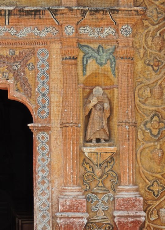
 San Roque, with his dutiful dog, occupies a niche on the middle right. Also called St. Roch, he was born in 1349 in Montpellier where his father was the local governor. San Roque and his dog also appear on the facade of the mission at Tancoyal. In Part 12, I told the story of this saint and the dog who saved him. His niche is framed by two Solomonic columns with ears of corn hanging on them. Miracles associated with San Roque began even before his birth. His mother was thought to be barren, but miraculously conceived and when the future saint was born, he had a cross-shaped birthmark.


Saint Michael waves his sword in triumph over Satan. St. Michael, as he is also known, is an Archangel, one of the most important of all angels. According to Catholic belief, he is the leader of God's armies and drove Satan from Heaven. St. Michael is nearly always shown with a sword in his hand and his foot on Satan, portrayed as a dragon. Above, Satan looks like a mountain lion with a semi-human face. The big cat was probably chosen rather than a dragon because the Pame craftsmen would have been familiar with mountain lions. Ears of corn hang down between the columns on either side of St. Michael.

A portrayal of the Trinity tops the facade. According to Catholic belief, the Trinity consists of the Father (God), the Son (Jesus), and the Holy Ghost. None of the three shown above is noticeably larger or dressed differently than the others, However, since God is the most important of the three, I assume he is the one in the center. Each of the three stands with one foot on the ground and the other raised and resting on a globe, presumably representing the world. This oddly casual group appears to be having a nice chat about the events of the day and the future of the cosmos.
This completes Part 13 of my Sierra Gorda series. I hope you enjoyed it. If so, please leave any thoughts or questions in the Comments section below or email me directly. If you leave a question, please include your email address so that I may respond in a timely fashion.
Hasta luego, Jim