Showing posts with label Southern Yucatan Peninsula. Show all posts

Friday, April 12, 2019

Dzibanché Part 4 of 4: The Acropolis of Kinichná

The Acropolis of Kinichná, viewed from the southwest corner. An acropolis is a citadel built on an area of high ground. Kinichná  ("The House of the Sun God") is a massive, four-level, pyramidal structure, with five temples on its upper three levels. Within the interior of the Acropolis, a royal crypt was found that contained the remains of two people. Scattered around the base of the structure are the remains of several small residential palaces which were the homes of a branch of Dzibanché's Kaan (Snake) Dynasty.

Kinichná is connected to the core of Dzibanché by a broad, flat causeway, called a sacbe, which is surfaced with limestone stucco. Sacbe means "white road", a name that refers to the color of the stucco surface. The one that runs between Dizbanche and Kinichná is 2km (1.2mi) long. The ancient Maya constructed many such roads to connect important precincts within a city, as well as to connect one city with another. After visiting Dzbanché's ceremonial complex, we drove the short distance to Kinichná to check it out. (Photo from Shore Excursioneer website)


Overview:

Unusual tree near the entrance of Kinichná. The Acropolis and its associated structures are surrounded by thick jungle full of unusual trees and plants. However, all this grew up after the site was abandoned, approximately 1300 AD. Before then, for at least a thousand years, the elite areas were surrounded by the homes of those who serviced their needs and, beyond that, by lush fields growing maiz and other crops.

The area around Dzibanche has an abundant supply of surface water, which is not typical of the rest of the Yucatan Peninsula. Most of the rest of  the Peninsula is a flat shelf made of porous limestone. Water, in those areas, does not remain on the surface to create rivers and lakes, but seeps down into underground caverns and river systems. In northern Yucatan, cenotes (sinkholes) provide nearly the only reliable access points. In areas lacking cenotes, the ancient Maya created channels to direct rainwater to bottle-shaped, underground storage pits called chultunes.

However, surface water is abundant in the southeastern Peninsula. Around Dzibanché, low lying areas collect rain water to form aguadas (seasonal ponds). One of these is adjacent to Kinichná. The aguadas were sometimes natural, but often were engineered. In addition, large swampy areas called bajos not only provided water, but also created a build-up of fertile sediments. The combination of water and fertile soil allowed for an agricultural system capable of providing sustenance to a large population. As a result, during the Classic Era, Dzibanché grew to cover 40 square kilomenters. Archeologists theorize that Kinichná was founded as a way to exert control over the fertile bajos to the north of Dzibanche's center.


A royal figure is dressed by servants in preparation for a great ceremony. The servant on the left adjusts a jade bracelet while the one on the right mixes pigment to be applied as makeup. The ruler is dressed in an elaborate costume, including a large quetzal-feather head dress and the skin of a jaguar. His lower legs and ankles are adorned by more jade. While the photo above is from a reproduction of a mural from another city, the rulers at Dzibanché probably looked very similar in appearance and dress. (Photo taken at the Museum of Maya Culture in Chetumal)

The Maya system of governance during the Classic Era bore some resemblance to the feudalism of Medieval Europe. The ruler of a single city was called ajaw (lord).The top figure in a city like Dzibanché was called kaloomté (overloard). The title indicates that ajaws from surrounding cities or towns owed him allegiance and probably tribute.

Many of Dzibanché's subject cities were ruled by members of the Kaan Dynasty, These ajaws often achieved their positions through marriage alliances or conquest. The images of the seventeen captives carved into the stone steps of the Temple of Captives were those of ajaws captured during conquests by Yuknoon Ch'een I, the kaloomté of Dzibanché in 495 AD. Almost certainly, the captives depicted were sacrificed and then replaced by Yuknoon Ch'een's relatives or trusted subordinates.


Maya rulers maintained and extended their domains using a warrior elite. It is probable that Kinichná was protected by warriors like these. In the center of the scene above, the leaders of two groups of warriors each grip the shaft of the same spear. This may indicate a meeting of allies, or perhaps a ritual in preparation for conflict between the two groups. The elite status of these warriors can be seen in their elaborate and expensive costumes. These include jaguar skins, exotic bird feathers, and even a crocodile totem. (Photo taken at the Museum of Maya Culture in Chetumal)

Maya warriors wore cotton under-armor, covered by palm-fibre armor. Other items of dress included a rigid waistband from which a long embroidered sash hung down the front. A short skirt made of flexible strips and knee protectors completed their battle dress. The warriors carried shields, either small and round or large and rectangular, depending upon their weapons. They were armed with a 2m (6ft) spear, as well as hand weapons made of wood and edged with obsidian. During the middle of the Classic Era, the influence of Teotihuacan was very strong. As a result, the Maya adopted the atlatl, a spear-throwing device used by Teotihuacano warriors. Not much is known about tactics, but the opposing armies appear to have fought in close order, with the ajaw and top nobility clustered in the center of the battle line. In addition to the political and economic goals of the war, capturing the enemy for sacrificial purposes was considered important.

The societal impact of Maya warfare appears to have reached far beyond the elite class and its warriors. The winning side often experienced an increase in population and wealth. Major building projects often occurred after victorious wars, enabled by captive labor. The losing city's population tended to decrease. Outlying districts were often abandoned, with the remaining population settling closer to the urban center. Building projects decreased or ceased for a time, as did inscriptions on stelae.

During the first half of the Classic Era, warfare was controlled and there appears to have been a code of behavior that inhibited wars of mass destruction and annihilation. However, by the end of the Classic Era, warfare seems to have become much more intense and widespread. All this violence was one of the causes of the collapse of the Classic Maya society between 900-1000 AD. However, it has recently been determined that Dzibanché, unlike its contemporaries, continued as a functioning Maya city state until about 1300 AD.


Level A: The base of the Acropolis


Large trees grow on the broad staircase leading from the plaza to Level B. I am not certain whether the trees were retained for aesthetic purposes or possibly to help maintain the stability of the structure. Level A is a huge, pyramidal foundation and is the tallest of the four levels of the Acropolis.


The stone walls on either side of the staircase are filled with large, abstract designs. Their meaning is unknown, at present. The designs may extend all the way around the base of the Acropolis, but much of the structure has yet to be excavated.


The un-excavated rear of the Acropolis. This is how the whole structure would have appeared when it was discovered in 1927 by an amateur British archeologist named Thomas Gann.


Level B's twin south-facing temples

Topographical schematic showing the approximate location of Level B. As you can see, the Acropolis completely dominates the landscape around it. As a man-made structure, it must have taken immense effort and thousands of man-hours to build. As an expression of Kaan power, it was intended to impress both Dzibanché's own population and the rest of the Maya world.


Level B contains two, identical, south-facing temples, one at either end of its broad terrace. These structures each have two levels, with a staircase on their south sides leading up to the temple on top. The rounded corners in the center of the photo show the influence of the Petén-style of architecture, popular in the Early Classic period (200-600 AD). All three levels of the Acropolis are from that era, along with its five temples and the royal burials under the top temple. At some point in the distant past, the temple above was looted.


The interiors of the twin temples each have two vaulted galleries. The temples are entered from a single doorway at the top of the temples' stairways. This photo was taken at the entrance of the west temple, looking toward the rear. The galleries have an east-west orientation and were once covered by corbel ceilings.

While the gods and rituals associated with these temples remain a mystery, there may be a hint in their geographic orientations. Both face south, which is one the five cardinal directions sacred to the Maya. In fact the entire Acropolis is aligned on a north-south, east-west basis. In the view of the ancient Maya, the cardinal directions (north, south, east, west, and center) were not simply set on a horizontal plane, but were three dimensional. North and south also represented up and down.


View of the back of the east-side twin temple. Both of the twin structures underwent at least three stages of construction involving enlargements of their bases, but no change to the temples themselves.

The orientation of the Acropolis and its temples is significant because the cardinal directions were considered sacred. Itzamna, the Maya creator god, had four sons called the Bakab. Each was assigned to hold up one of the four corners of the world, which corresponded to four of the cardinal directions. Itzamna was apparently in the center. The Bakab named Hosanek was given responsibility for the world's southern corner. The four Bakab were also associated with Chaak, the all-important god of rain. So, it is possible that prayers and rituals associated with Hozanek, or Chaak, or both, could have taken place here.


Drawing of a small figure found on Level B. It is probable that the little statue had some ritual purpose. The figure stands with its hands raised, wearing what looks like modern boxing gloves. The closed eyes, expressionless face, and raised hands give the appearance of prayer. However, that may only reflect my modern perceptions.


A broad staircase extends up from Level B's terrace to Level C. A tourist steps carefully as she makes her way down the ancient steps. Level C's east and west temples face each other on either side of the top of the stairs. Between and above them stands the the top-most temple, a dark doorway showing its single entrance. On either side of the staircase are four large, sloping panels which can also be seen in the first photo of this posting. Two panels are on each side, with one above the other. Each of these panels once contained a big stone mask.


Lower right panel, next to the staircase. In the middle of the panel are the remains of the mount where the mask was placed. The masks are believed to have represented Kinich Ahau, God of the Sun. The discovery of a Sun God mask gave the Acropolis its name: House of the God of the Sun, or Kinichná. Similar masks of Kinich Ahau are still in place on either side of a temple staircase in the ancient Maya city of Kohunlich, not far to the south of Dzibanché. We will visit Kohunlich in a later posting.


Level C's twin temples face west and east.

The front of the west temple faces the rising sun. Level C's twin temples each have a single gallery, oriented on a north-south basis. Each also has a single entrance, which is gained by a four step stairway. Of the five temples on the Acropolis, these are the only ones that do not face south. Once again, the gods and rituals connected with Level C's temples are not known. However, Kinich Ahau is associated with the east, where they believed the sun is born each day. A priest facing outward from the doorway of the temple above would be looking east, toward the rising sun.


The twin temple on the east side of Level C faces toward the west. The four steps leading up to the temple can be seen in this photo. If you stand in the doorway of this temple, looking out, you face in the direction of the setting sun. That is where the sun goes to die, before being reborn the next morning. Other interesting features of the twin temples include the sloping walls, or pediments, leading from the base of the temples down to the Level C terrace. Directly above each sloping wall is a vertical panel. This arrangement may reflect the talud y tablera architectural style of Teotihuacán. The influence of Teotihuacán on the Maya was greatest during the Early Classic period when the Acropolis was built.


The topmost temple

The temple at the Acropolis' summit faces south. The staircase ascending from the Level C terrace to the temple has nine steps, a significant number to the ancient Maya. Xibalba, the underworld of the dead, had nine levels. The number of stairs here may be a reference to the tomb found under the temple. In terms of the sacred directions, this is the most northern of the five temples and occupies the highest position on the Acropolis. In addition, the temple faces south and looks down to the plaza far below. Thus, from the Maya point of view, the temple has both horizontal and vertical orientations. Itzamna is associated with both the sky and the center of the world. This temple is both the highest point on the Acropolis and the center of the whole structure. Given all that, my best guess is that Itzamna may have been worshipped here.


The front gallery of the top temple. The temple has two galleries, or corridors, laid out east to west. Above, you can see the remains of the corbel arch that once formed the ceilings of both galleries. The entrance is on the right, above, and the passage continues through to the back gallery. Against the wall of this gallery you can see two low benches, or possibly altars. Underneath the temple floor, archeologists found a tomb containing the remains of two people.


Finely carved jade masks were among the grave goods buried in the tomb. The drawing above is an artist's rendering of the masks. I have been unable to find any photographs specifically identified as the masks from this tomb. The tomb's location, as well as the amount and quality of carved jade and other grave goods, both suggest the burial of at least one kaloomté from Dzibanché's early Kaan Dynasty. It is possible that the second set of remains belongs to his wife or a close relative.


View toward the southeast from the front of the topmost temple. Given the height of the Acropolis, and the generally flat terrain around it, the vista is magnificent. I was glad that the authorities have not yet prohibited climbing its daunting set of staircases. Now, the real fun begins because the climb down from one of these places is always the most precarious.

This completes Part 4 of my Dzibanché series and marks the end the series itself. I hope you have enjoyed visiting Dzibanché and learning about its powerful Kaan Dynasty. If you would like to contribute any thoughts or leave a question, please do so in the Comments section below, or email me directly.

If you leave a question in the Comments section, PLEASE leave your email address so that I can respond.

Hasta luego, Jim

Sunday, March 31, 2019

Dzibanché Part 3 of 4: Plaza Xibalba and the Pyramid of the Owl

Pirámide del Buho, occupies the east side of Plaza Xibalba. Its rounded corners show evidence of the Petén style of architecture popular in the Early Classic period (200-600 AD). While excavating a royal tomb inside the pyramid, archeologists found numerous grave goods, including a ceramic bowl with an image that gave the pyramid its name.

In Part 3 of my Dzibanché series, we will take a look at this pyramid and two of Plaza Xibalba's other structures.  Of the 22 plazas that archeologists have so far identified, Plaza Xibalba appears to have been the most important. It was the most important ceremonial area of the Kaan (Snake) Dynasty, which originated at Dzibanché around 200 AD and eventually extended its domination over most of the Late Classic Era (600-1000 AD) Maya world.

Overview: Plaza Xibalba

Site map of Plaza Xibalba. The plaza stands just to the east of Plaza Gann, the area we examined in Parts 1 and 2 of this series. The Plaza Xibalba's platform is about 4m (12ft) above Plaza Gann and is accessed via stairways on the north and south sides of Pirámide de los Cormoranes (Edificio 2). In fact, the rear of Edificio 2 forms the west side of Plaza Xibalba. Directly across from it is Pirámide del Buho (Pyramid of the Owl), also known as Edificio 1. It is the largest structure at Dzibanché. Occupying the the north and south sides of Plaza Xibalba are two nearly identical structures called Palacio Norte and  Palacio Sur. Archeologists named the plaza after the Maya underworld because of its many associations with death and the afterlife.


Xibalba mask from Chetumal Museum of Maya Culture. Xibalba (Shee-bal-ba) means "Place of Fear" in the K'iche' Maya language. Access to the underworld was through caves or cenotes (limestone sinkholes filled with water). Xibalba was ruled by twelve gods collectively known as the Lords of the Underworld. They had horrendous names like "Flying Scab", "Bone Staff", "Pus Demon" and "Bloody Claws". Chief among these Lords were the two gods: "One Death" and "Seven Death".

Xibalba had nine levels through which the newly dead had to pass. Each level contained traps and tests, including hazards such as crossing raging rivers of blood and passing through rooms filled with fire, ravenous jaguars, and razor-sharp obsidian blades. Maya tombs often contain items which were thought to aid the dead in accomplishing this fearsome journey. These include weapons, tools, food, and precious items such as jade. The requirement to pass through Xilbalba had nothing to do with personal conduct, or one's good or bad acts while living. The only way to avoid the journey was to die a violent death.


Edificio 1 - Pirámide del Buho 

Like many of Dzibanché's structures, the Pyramid of the Owl was constructed in multiple stages. The earliest phase was a much smaller pyramidal platform built sometime between 200-300 AD. The remains of this initial pyramid were later used as the core of the one seen above. The later structure was built in several phases between 300-600 AD. The Pyramid of the Owl has four stepped levels with a broad staircase facing to the west. The second, third, and fourth levels have large panels on either side of the stairs. The surfaces of these panels were once stuccoed and painted. During the Late Classic, large stone masks were mounted on the panels, an indication of the influence of the Rio Bec architectural style.


Staircase of the Pyramid of the Owl, viewed from the top of Palacio Sud. The staircase is impressively steep, with four landings. The man descending is stepping very carefully on his way down the narrow stairs. A slip could be dangerous, possibly even fatal. As a result, access to the upper levels of many of Mexico's ancient pyramids and monuments has been prohibited in recent years. I understand the reasoning, but it often closes off some wonderful photographic opportunities. Fortunately for me, climbing was permitted on this particular pyramid.


Schematic of the Pyramid of the Owl, viewed from above. Although the Pyramid of the Cormorants may be a bit taller, the Pyramid of the Owl is, overall, the larger of the two structures. In design, the Owl Pyramid shows some similarity to the much smaller Pyramid of the Lintels, seen in Part 1. The temple at the top contains a relatively small, narrow room which was once covered by a vaulted, corbel ceiling.


Entrance to the temple is restricted by a barrier. However, the room inside is easily photographed from behind the barrier. The terrace in front of the temple gives a good view of the Plaza Xibalba, the rear of Pirámide de los Cormoranes and other areas of Dzibanché.


South end of the narrow, vaulted temple room shows evidence of smoke. A small seat or altar occupies the southeast corner of the room. There is a similar structure at the north end of the room. I am inclined to believe that these are altars because of the evidence of blackened areas on the walls at both ends of the temple. This probably indicates smoke from ritual fires.


A third seat, or altar, stands against the back (east) wall inside the temple. This one has an interesting slot near its middle. I have found no information as to the purpose of the slot, but it might once have contained a statue or other ritual object. This structure faces the entrance of the temple, strongly suggesting an altar. In 1994, archeologists examined the floor in front of this altar and found the beginning of a stairway. When they were cleared, the stairs led down into the interior of the pyramid, all the way to the level of Plaza Xibalba. There, the excavators found a recessed tomb containing the remains of a woman, obviously of great status, possibly even a queen. Her grave goods are some of the finest found at Dzibanché.


The owl on the lid of this funerary bowl gave Pirámide del Buho its name. One of the finds was a lidded pot decorated with the image of an owl (buho) with its wings spread. Archeologists were so impressed that they named the pyramid after it. To the Maya, owls were the harbingers of death and closely associated with Xibalba. It is not, therefore, surprising to find an owl depicted on a funerary pot. Owls were also powerful symbols at Teotihuacán, the great empire which so strongly influenced the Classic Maya. Palacio Atelcothe military academy of Teotihuacán, is decorated with birds with extended wings that may be owls (although they might also be eagles). Further, the Teotihuacán military leader who took power in Tikal in 378 AD--either through conquest or a coup d'etat--was named Spear-thrower Owl. (Photo from Latin American Studies website)


This engraved Spondylus shell was also found in the tomb. The shell is set with jade and shows a ruler sitting cross-legged on a throne. The relief carving is inlaid with jade and black coral. The figure on the throne wears a nosepiece and ear spools of jade, as well as jade ornaments on other parts of his body. On his head, he wears the emblem of the "jester god", which signifies royalty. In his arms, he holds a rattlesnake. Another snake is also depicted and a deity emerges from its jaws. All this may refer to a previous ruler or possibly a mythical culture hero. The style corresponds to the period from 450-550 AD. (Photo from Arqueologia Mexicana website)


The Diving God decorates a censer found at Dzibanché. A censer is a ritual device used during religious ceremonies to burn incense, usually copal. Among the pantheon of Maya gods, the Diving God (Ah-Muzen-Cab) was especially important. Archeologists nicknamed him the Diving or Descending God because he is always depicted in an upside down posture, as if he were diving out of the sky.

Although he is portrayed here in human form, he sometimes appears as a bee because he is the god of beekeepers, bees, and honey. Maya beekeeping began thousands of years ago, but became particularly prevalent during the Post Classic Era (1000-1520 AD). The Maya used a species of stingless bee that they called Xunan Kab, but its scientific name is Melipona beecheii. They used honey to make balché, an alcoholic drink consumed in religious festivals. In addition to local consumption, honey was also an important trade item. (Photo from Wikimedia Commons)


The rear of the Pirámide de los Cormoranes forms the west side of Plaza Xibalba. This shot was taken from atop Pirámide del Buho, looking west. The irregular stonework at the top of the Pyramid of the Cormorants is what remains of the large roof comb that once rose above its temple. Below the roof comb, in the lighter colored stone, you can see two large, rectangular surfaces. They are part of a series that cover the back and sides of the pyramid. They show the architectural influence of Teotihuacán.


Palacios Sud y Norte

Large rectangular pillars line the front of Palacio Sur on the south side of Plaza Xibalba. Just in front of the pillars is a long, narrow terrace from which the ceremonies in the plaza below could be viewed by elite spectators. The pillars are separated by nine entrances along the front of the building. There used to be a broad staircase rising up from the plaza to the level of this terrace. However, after the Spanish Conquest, the staircase was dismantled and the stones reused for Spanish buildings elsewhere. Only a grassy embankment remains.


Schematic view of Palacio Sur from above. The structure is in the form of a low, stretched-out pyramid. There are three lines of pillars and roof supports that create two long, narrow galleries. Ten pillars are on the front, with another ten on the rear, while the middle row contains six. There are nine doorways on the front and another nine on the rear. Numbers were always significant to the Maya, and nine is the number of levels in Xibalba. The only doorway through which you can pass directly through to the back of the building is the central door. All the other doorways are offset. Facing Palacio Sur on the north side of Plaza Xibalba is Palacio Norte, a virtually identical structure. Because of this close similarity, I will only show Palacio Sur in this posting.


Front corridor of Palacio Sur. When I first climbed to the top of Palacio Sur, I was puzzled by the structure of the building. It did not seem to be a sensible arrangement for a living space with the name "palace". The extremely long, narrow corridors would have created a difficult passage for two people approaching each other. Further, unlike Palacio Pop in Plaza Gann, there are no sleeping compartments, storage areas, or large rooms for social gatherings.

The answer, apparently, is that Palacios Sur and Norte are not really elite residential spaces at all. Instead, they form, along with Pirámide del Buho,  an elaborate funerary monument to the Kaan Dynasty female who is buried in the pyramid. Plaza Xibalba is therefore entirely ceremonial in function, and the elite residential and administrative structures are located elsewhere.

Bowl found in a Dzibanché tomb. This is yet another example of fine craftsmanship. While this bowl was used for funerary purposes, it could just as well have been used to serve dinner to an elite family. (Photo from Latin American Studies website)


How the nobles who lived a Dzibanché may have appeared. I took this photo at the Museum of Maya Culture in Chetumal. The mural is a reproduction of a mural found in a room at a different Maya city. There are no similar murals at Dzibanché to show us the appearance and adornment of the Kaan Dynasty elite, but they probably looked very much like this.

The male figures wear extravagant head dresses and rich jewelry of jade and other rare stones. Their shoulders are draped with long, white, cotton cloaks with embroidered hems. The only other forms of clothing they wear are embroidered loin cloths with long extensions draping down the front. In Yucatan's typically warm climate, other clothing would be superfluous.

This completes Part 3 of my Dzibanché series. I hope you have enjoyed it. If you would like to leave any thoughts or questions, please do so in the Comments section below or email me directly. If you leave a question in the Comments section, PLEASE leave your email address so that I can respond.

Hasta luego, Jim


Saturday, March 23, 2019

Dzibanché Part 2 of 4: Plaza Gann and the Pyramid of the Cormorants

Pirámide de los Cormoranes. The Pyramid of the Cormorants is the largest structure at Dzibanché. It has many fascinating features, including the burial crypt of a famous king and mysterious relief carvings beside one its staircases. The pyramid got its name when archeologists excavated the king's crypt. There, they found a vase with the image of a large, aquatic bird called a cormorant.

Dzibanché is believed to be the original capital of the Kaan (Snake) Dynasty, who founded the city approximately 200 AD. The city was once thought to have been abandoned in 1000 AD, at the end of the Classic Era. However, recent discoveries show that it was occupied until about 1300 AD, well into the Post-Classic. Although the Kaan Dynasty got its start at Dzibanché, the Kaan eventually came to rule--directly or indirectly--many Classic Era Maya cities. Eventually, this included Calakmul, the greatest and most powerful of them all.

Overview of Plaza Gann

Site map Plaza Gann. I devoted part of my last posting to Templo de los Cautivos (Edificio 13), which stands on the plaza's west side, along with its south and north wings (Edificios 12 and 14). In this posting, I will walk you around the other three sides of the plaza, which includes Pirámide de los Cormoranes (Edificio 2), which occupies the east side of the plaza, Palacio Pop (Edificio 11) on the south side, and Templo de los Tucanes (Edificio 16) on the north.

The archeological site that we visited is actually only a small part of what was once a sprawling urban complex. Dzibanché's maximum extent may have been as large as 40 square kilometers. Although twenty-two separate plazas have been identified, only a handful have been excavated. Quite literally, archeologists have barely scratched the surface. In future years, it is likely that the Snake Dynasty's ancestral home will reveal many more of its secrets.


Edificio 2: Pirámide de los Cormoranes

Pyramid of the Cormorants, viewed from its southwest corner. The staircase on the right of the photo leads up to the Plaza Xibalba which is bordered by the Pirámide del Buho (Pyramid of the Owl) and two more palaces. In this shot, you can see the pyramid's rounded corners. These are typical of the Petén architectural style popular during the early Classic Era.


Two of the three entrances into the interior of the pyramid. The third entrance is in the center of the stairs near the top. In my research, I have been unable to find any mention of these entrances and whether they are of ancient or modern origin. However, they may be the tunnels dug by archeologists which allowed them to discover burials in the pyramid. One of these graves contained the remains of Sky Witness, the 17th Kaan ruler of Dzibanché. His reign spanned the period between 561 to 572 AD.


Vase from Sky Witness' crypt in the Temple of the Cormorants. The crypt contained not only the bones of the ruler, but rich grave goods, suitable for a monarch. The image of a cormorant on this vase prompted archeologists to name the pyramid after it. Following ancient Maya funeral practices, the vase was ritually "killed" by punching a hole in it. But, there was much more than the vase in the tomb. (Photo from latinamericanstudies.org)


Jade masks were also found in the grave. Jade masks, ornaments, and various ceramic pots were also found in the crypt. Only the most elite members of Maya society, usually the rulers, were buried with elaborate jade masks like these. The elaborate jade mask covering the face of Palenque's ruler, Pakal the Great, is another example. Jade was considered not only a a sacred substance, but was as valuable to the ancient Maya as diamonds are in today' society. (Photo from Quintana Roo website).

The physical remains of Sky Witness tell an extraordinary story. An osteological analysis of the bones shows that, when he died, Dzibanché's 17th Kaan ruler was a powerfully built young man in his 30s. His relative youth at death fits with his surprisingly short, 11-year reign. The skull bears the healed scars of many battles, which indicates that he personally led his warriors into the thick of the fray. It is unknown, at this time, whether Sky Witness' early demise resulted from battle injuries or natural causes.


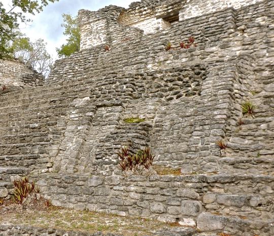
View from the northwest corner. On the left, you can see another set of stairs leading up the side of the pyramid to Plaza Xibalba. Beside the stairs are thatched palapas, put there to protect polychrome stucco wall decorations that were revealed when a later wall was dug away. Several large pediments are visible between the palapas and the main staircase on the right. More pediments can be seen on the temple at the top of the pyramid, and others are on the back. Like those found on the Templo de los Linteles, the pediments are a further indication of the influence of Teotihuacán, the great trading metropolis lying more than 1300 km to the west. The temple at the top of the pyramid contains two long galleries with corbel-arched ceilings. Rising high above the back of the temple are the remains of a large crest, called a "roof comb". This was a support structure for three large masks or medallions that were once mounted there.

Sky Witness won fame as the conqueror of Tikal, the Snake Dynasty's great rival during the Classic Era. However, he does not deserve all the credit. His predecessor, the 16th Kaan ruler, was named  Stone Hand Jaguar (K'ahk' Ti' Ch'ich'). This very astute ruler laid the groundwork for Sky Witness' later triumph. Stone Hand Jaguar lived a thousand years before Machiavelli, but he would have perfectly understood the intrigues and conflicts among the city-states of the Italian Renaissance.

Archeologists believe that Tikal's somewhat mysterious relationship with Teotihuacan may have been a key factor bolstering its power. Established in the mid-5th century, this connection is believed to have provided one of the main channels for the spread of Teotihuacán's influence throughout the Classic Maya world. In the mid-6th century, as Teotihuacan began to decline, its connection with Tikal weakened and eventually ended. This loss, in turn, contributed to a decline in Tikal's power and influence. Moving into this power vacuum, Stone Hand Jaguar quietly and patiently built a web of alliances. Over a period of twenty years, he gradually surrounded Tikal with hostile city-states who had tired of its domination.


Stucco relief carvings decorate the left side of the Pyramid of the Cormorants. The carvings follow the stairs as they rise up to Plaza Xibalba. They show traces of the red paint with which they were once coated. Like the talud y tablera motif of the Temple of the Lintels, these designs show that the cultural influence of Teotihuacán extended even to the capital of the Kaan Dynasty.

Stone Hand Jaguar's political outreach included dynastic weddings with other ruling houses and arranging ball games between Dzibanché and other city-states. Other tactics included gifts to his counterparts during a long series of "social" visits to their cities. All this is known from glyphs and carvings on the walls and stelae of the cities he targeted for alliances. Individually, these carvings appeared to have no particular significance. However, when archeologists viewed them collectively, a distinct pattern of sophisticated political intrigue emerged. It was as if Machivelli's book, The Prince, had been written in ancient Maya glyphs.


Stucco wall design. I was puzzled by these designs, because I was unable to find human or animal figures or glyphs. The design above may be of a flower at the end of a sinuous stem or something entirely different. Many of the images are abstract, with some having repetitive elements.

Among the cities Stone Jaguar courted were Caracol to the southeast of Tikal, and Naranjo and Holmul on the east. Waka, to the west, had a particularly warlike reputation and was thus an object of special attention. Eventually, Tikal was isolated and surrounded. Stone Hand Jaguar died before he could see the fruits of his efforts. It was left to his successor, Sky Witness, to carry out the long-range plan.

When all was ready, Caracol, supported by Naranjo and Holmul, attacked from the southeast. Meanwhile, Sky Witness led the forces of Dzibanché and Waka in the west. According to an altar-carving at Caracol, Sky Witness attacked Tikal on April 29, 562 AD. He defeated its army, sacked the city, and sacrificed its king on his own altar. Tikal would not rise again for another 130 years.

Edificio 11: Palacio Pop

View of Palacio Pop from its west end. Palacio Pop occupies most of the south side of Plaza Gann. The name "Pop" refers to the first month of Haab, the Maya's 365-day secular calendar.  The Haab, in conjunction with the sacred 260-day Tzolk'in calendar, followed the 52-year cycle of the Calendar Round. The Maya are famous for the sophistication and accuracy of their calendars, which ruled every aspect of their society.

Pop was the first month of the year and it was preceded by fasting and abstinence. The first day of Pop was celebrated by feasting, drinking and gift-giving. To the Maya, Pop symbolized community and marriage. I have not been able to determine why the archeologists gave this structure its name. It could have been related to artifacts found here, or perhaps they excavated it during the month of Pop.


East end of Palacio Pop. This is the oldest part of the palace. Above, you can see the several stepped levels and to the right is one of the balustrades of the stairs. The palace was an elite residence constructed in phases during the late Classic era (600-1000 AD). Edificio 11 is long and rectangular and its top level is divided into three rooms. The smaller rooms on each end are separated by a large one in the middle. There are five doorways in the front wall of these rooms and two doorways in the rear.


The Palace from the rear. The south side of Palacio Pop has a large terrace. This area may have contained additional rooms at one time, possibly made from perishable material. Alternatively, it could have served as an area for outdoor living.


The central room contains two broad benches along its rear (south) wall. The benches may have served as seats during the day and beds at night. In the space between the benches is a door leading to the rear terrace. Three of the five doorways on the front (north) wall can be seen above.


The east end of Palacio Pop contains a smaller room with an L-shaped bench. The wall that partially separates this room from the larger one indicates that this was a private space, possibly a bedroom. The man repairing the wall in the background is one of the site's maintenance workers. The small room at the opposite end of the palace also contains a wide bench, but only across the end of the wall.


View from the top of the palace's stairs toward Plaza Gann. There are several different sets of stairs on the front (north) side of the palace, leading up to the rooms on top. There are several more small rooms on the lower levels on either side of the main staircase facing the plaza.

Limestone was the material used to build Dzibanché's stone structures. The whole Yucatan Peninsula is a large, flat, limestone shelf that used to be seabed. The stone lies at or just under the surface of the soil in many places, making it easy to quarry. Limestone is relatively soft and light-weight, making it ideal for building monumental structures, as well as for the sculptures and stelae found throughout Yucatan.


A fire ring stands in the entrance of a room. I thought this a very odd placement for a fire ring. When entering or leaving the room, you would have step very carefully to avoid the fire. None of the explanatory signs mentioned this fire ring, which left me speculating on its use. Perhaps it--and the room--had some ritual purpose? At other sites in Yucatan and elsewhere, I have nearly always found rings like this either in the center of a room or against one of the walls.


Lidded pot found at Dzibanché. The snarling jaguar and intricate painted designs demonstrate a high quality of workmanship. This shows the level of sophistication of Dzibanché's elite and a quality of life that would have been envied by their contemporaries in Europe. Intact ceramics like this are usually found among grave goods, particularly if the crypt has not been looted. Works like this would never have survived for a thousand years on the surface. (Photo from latinamericanstudies.org)

Edificio 16: Templo de los Tucanes

Templo de los Tucanes occupies the north side of Plaza Gann. The temple is named after the toucan, a large bird with a colorful, curved beak that inhabits the jungle around Dzibanché. This structure, also known as Edificio 16, is a temple with three stepped levels and a broad staircase which extends across the front of the building. This staircase has three flights of stairs, built like "stadium seats". Seated here, elite audiences could watch ceremonies taking place in Plaza Gann.

The Temple of the Toucans was modified four times over the centuries. The first two constructional stages occurred in the Early Classic (300-600 AD), with another during the Late Classic (600-900 AD). The final modification occurred during the Terminal Classic (900-1000 AD). During the changes, annexes were added on both ends, the staircase was changed and enlarged, and the vaulted rooms once located on the top level were demolished to create more space.


Two large masks decorate the eastern end of the temple, one above the other. The one on the bottom is shown above. At one time, this mask was covered with stucco and painted. These materials have long-since worn away, leaving only the stone remnants.

At the center of the photo is a small emblem that looks like a petalled flower circled by a ring. The flower is in the middle of the mask's open mouth, with a prominent chin just below. Above the mouth is a large curved nose, looking like it belongs to a boxer who has been in too many fights. On either side of the nose are rounded cheeks and above these are slitted eyes. Framing the face is an elaborate hairstyle, or possibly a head dress.


View of Templo de los Tucanes from the east side. Just to the right of the stairs, you can see the stepped levels containing the masks. Archeologists believe that rooms made of perishable materials, probably wood and thatch, once occupied the top of the temple. The remains of the eastern annex, added after the initial construction phase, can be seen at the far right.


The second mask is above and set back from the first. Once again, the stucco and paint are gone but the mask can still be discerned. At the bottom of the face is a slightly receding chin. Above it is an open mouth, surrounded by fleshy lips. In the center of the face is a hooked nose and on either side, above the nose, are two square eyes. The meaning of these masks is lost in the mists of time. However, their prominent placement on the front of this temple signifies that the gods, or persons, that they represent were important to Dzibanché's people.

This concludes Part 2 of my Dzibanché series. I hope you have enjoyed it and, if so, you will leave any thoughts or questions in the Comments section below, or email me directly. If you leave a question in the Comments section, PLEASE leave your email address so that I can respond.

Hasta luego, Jim