Sunday, February 23, 2020

Edzná Part 5 of 8: The Temple of the Masks, the South Temple, and the Ball court

Stucco mask of K'inich Ajaw, the Maya Sun God, at the Temple of the Masks. Two large masks adorn the front (north) side of the temple. The mask above is on the eastern side of the temple's main stairway and represents the rising sun. The mask to its west (see below) represents the sun as it sets. The large bulging eyes and protruding front tooth are features found in representations of K'inich Ajaw not only at Edzná but at other Maya sites in the southern Yucatan Peninsula, Belize, and Guatemala.

In my last posting, I showed the Small Acropolis, which forms the eastern boundary of the South Plaza. In this posting, I will show some of the temples and other structures that lie to the west of the Small Acropolis and border the South Plaza's north and south sides. These include the Temple of the Masks, the South Temple, and the Ball Court. Once again, most of my information comes from the archeological report by Antonio Benavides Castillo, entitled Edzná, A Pre-hispanic City in Campeche. Where I have used information from other sources, you will find a link to them.


The Temple of the Masks (Structure 414) is located just west of the Small Acropolis. It forms part of the southern boundary of the South Plaza. The Temple was named for two large stucco masks found on either side of the north-facing staircase. They are protected by the thatched palapa along the front of the temple. The remains of Sacbe 3 can be seen in the foreground. It is an ancient processional road that bisects the South Plaza from east to west, connecting the western staircase of the Small Acropolis to the South Temple.

The dimensions of the rectangular temple are 27.4m (90ft) in length and 16.5m (54ft) wide. The average height is 5.5m (18ft). When the structure was first excavated, the more recent modifications had deteriorated significantly. Most of the features we see today are in the Early Classic Petén-style (300-600 AD) Parts of the substructure are still covered with stucco which had originally been painted bright red and may date as early as the Late Pre-Classic period (1 AD-300 AD)


Floor plan of the Temple of the Masks. The temple faces north, toward the bottom of the schematic above. There are stairways on the east, west, and north sides. One small room sits at the top of the pyramid. Its only doorway opens toward the north, over the main staircase. The room was once roofed with perishable materials, probably similar to the palapa that today protects the masks at the bottom of the pyramid's north side. The stucco masks, with their associated symbols, are located on either side of the bottom of the main staircase. There is evidence that two additional masks once decorated the second level just above the first two. However only the lower level pair still exist.


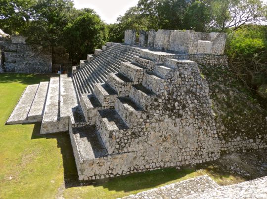
View of the Temple of the Masks from the southeast cornerOn its south side, a sloping Petén-style ramp rises from the ground level to the badly-deteriorated third tier of the temple. The thatched roof of the palapa can be seen in the photo's upper right quarter. The stonework of the first two tiers, as well as their sharp-angled corners, are clearly in the Petén style.


The mask on the west side of the main stairs represents the Sun god at sunset. As I mentioned earlier, the east side mask represents sunrise. While there are some differences, the two have a number of common features. These include huge bulging eyes with crossed pupils, protruding front teeth, elaborate head dresses, and a squinting expression called a strabismus. The dimensions of the masks are also similar. Along with the symbols that stretch out on either side, each mask measures 3m (10ft) wide x 1m (3.3ft) tall. Both masks had once been brightly painted and some traces of this remain. While the predominant color was red, other colors included blue, black, burgundy, ochre and green. 

The masks show the faces of K'inich Ajaw, the powerful Sun God. Each day, he appears in the east, the Maya's most revered direction, before setting in the west. K'inich Ajaw was an aspect of Itzamna, the supreme creator god and was associated with warfare and royalty. Maya kings were thought to "assimilate" to K'inich Ajaw when they departed this life.


Drawings of the two masks and their associated symbols. At the top is the eastern mask, with the western one below. There is one additional similarity. In both cases there are truncated columns on each side of the masks. The columns are made up of square boxes, each containing an "X". The drawing indicates that there may have been additional Xs above the ones shown. The Maya symbol for X represents the word hal which means "to manifest". This might indicate that the masks manifest the dual aspects of K'inich Ajaw: sunrise and sunset. 

There are also differences between the masks. The head dresses are not the same, nor are the ear plugs. In addition, the eastern mask has animal faces within the head dress and below the earplugs, while the western mask does not. The meaning of these differences is not clear, but perhaps they are meant to indicate the difference between sunrise and sunset.

The South Temple

View of the South Temple from its southeast corner. The South Temple is a large pyramid that, together with the Ball Court, forms the boundary between the South Plaza and the Main Plaza to its north. The temple faces south, into the South Plaza. The pyramid is a very ancient structure which has been periodically modified and enlarged during its 1000 years of use. During its excavation, archeologists discovered a much older structure covered with stucco that dates back as far as the Pre-Classic period. 

Most of the five-level pyramid we see today is in the Early Classic Petén style. There are two rooms on top that were added in the Late Classic. The larger room has a door that opens to the south and looks out over the pyramid's broad staircase into the South Plaza. There is a smaller room behind it that connects to the larger room by an interior door. The smaller room may have been an inner sanctum where important rituals could be performed out of sight of the uninitiated.


Floor Plan of the South Temple. North is at the top of the schematic. The Petén elements include the recessed corners on each of the five levels, as well as the broad sloping ramp in the rear. The ramp is similar to those found on the rear of the Small Acropolis temples, but much larger.

Adjacent to the South Temple is the western side of the Ball Court. When archeologists first surveyed the site, they assumed that it was one big structure, rather than two. However, excavation revealed a narrow alley between the Ball Court and the South Temple. The passageway had been filled during either the Late Classic era or Post-Classic.


Rear of the South Temple and the north end of the Ball Court. The broad grassy area in the foreground is part of the Main Plaza. The South Temple's steep ramp can be seen sloping up its rear side. I first saw the ramp from the northern end of the Main Plaza. At that moment, I assumed that I was looking at the deteriorated main staircase on the front of the pyramid. However, when I approached more closely, I realized that it was the rear of the structure and that the "staircase" was actually a large ramp. 

The northern end of the western side of the Ball Court is visible to the left of the South Temple. It has a single room on top with four east-facing doorways separated by three pilasters. The room once had a vaulted stone roof. It sits on a terrace accessed by a small staircase on the north end. The sloping portion of the building is part of the playing area. A small dark object can be seen in the middle of the slope near the top. This is a fragment of a stone ring, through which players would try to propel the ball. Nothing remains of the ring once located on the eastern side of the court.


The Ball Court


View from the south end of the Ball Court's main playing area. To the left is the western sloping wall seen in the previous photo. The slope to the right is the eastern part of the playing area. The width of the playing area is 5m (16.4ft), measured from the top of one slope to the other. The length of the court is at least 23m (75.5ft). However, archeologists believe that the actual length may have been 51m (167ft). If so, the actual northern boundary of the court may once have been the low stone structure that can be seen just below the trees in the background.

On top of the eastern sloping structure is another room surrounded by a terrace. Like its twin on the west, the eastern room also has four doorways separated by three pilasters. However, this time the doorways face west. The roof of the eastern room, like its western counterpart, was once covered by a corbel vault.


Diagram of the Ball Court and its associated structures. The two halves of the court can be seen, with the narrow corridor between them. To their north is the low structure that might have once have been the court's northern boundary. Angling off to the right of this structure is Sacbe 2, which ends at the main staircase of the Great Acropolis, indicating an important link between the two. The Ball Court was constructed in the Puuc style of the Late Classic era.

Standing at a right angle to the eastern side of the Ball Court is another building. It faces south and is topped by a single long room with five doorways separated by four pilasters. A broad staircase leads up to these doorways from the South Plaza. The whole structure was originally covered by a thick coating of stucco and painted bright red. Archeologists at first thought the right-angled building was part of the Ball Court complex. However, recent excavations have revealed that it was constructed in the Early Classic Petén style, thus pre-dating the Ball Court by several centuries.


View of the eastern half of the Ball Court complex from its north end. The eastern half differs from the western in two ways. There were two rooms on top, one facing west toward the playing area and the other facing east. These rooms and their surrounding terrace were accessed by the staircase you can see on the eastern side of the structure. By contrast, the western side of the Ball Court has a small staircase on its northern end. Another difference is the small room on the north end of the eastern structure. Leading up to the room is a broad three-step staircase, at the top of which are three doorways  separated by two pilasters. The roof was originally covered by a corbel vault.


Diagrams showing a re-construction of the Ball Court and its stone rings. In the drawing on top, you are looking north down the length of the court. The corbel vaulted rooms can be seen on either side, as well as the position of the stone rings at the tops of the walls. Elite spectators would have watched the game while sitting or standing on the terraces or in the doorways of the rooms. People of lesser status would watched from the ground level at either end of the playing field.

The overall diameter of the rings is 1.12m (3.7ft), while the diameter of the holes through which a ball must pass is .56m (1.8 ft). The balls were made from hard rubber surrounding a core of stone. They varied from the size of a softball to a soccer ball. Little is known about the specific rules of the ball game, but they appear to have changed somewhat over the centuries. Use of the hands during play was forbidden and the ball was propelled by shoulders, elbows, or hips. In addition to passing the ball through a ring, there may have been other ways to score. In fact, the rings were Late Classic or Post-Classic innovations. The average size of teams varied from two to six on a side.

The Maya Ball Game originated 3,000 years ago and was much more than a simple athletic contest conducted for sport and entertainment. The game was imbued with deep religious, cultural, and political meanings and was sometimes used to settle disputes within the community or between rival cities. Human sacrifice, usually by beheading, was closely associated with the game. Some times those sacrificed were war captives, but sometimes it was the players themselves. In the second case, there is some dispute as to whether it was the losers or the winners who were sacrificed.

This concludes Part 5 of my Edzná series. I hope you have enjoyed it. If so, please leave any thoughts or questions in the Comments section below or email me directly. If you leave a question in the Comments section, PLEASE also include your email address so that I can respond.

Hasta luego, Jim

Saturday, February 15, 2020

Edzná Part 4 of 8: The Small Acropolis

The Temple of the Decorated Stairs, viewed from the plaza of the Small Acropolis. This is the most important structure on the Small Acropolis, both because of its size and because it occupies the east side of the Acropolis. East is the most important of the Maya's sacred Cardinal Directions. The temple gets its name from bas relief images and hieroglyphs carved into the risers of the stairs you see above.

My previous two postings covered the Great Acropolis, which occupies the east side of Edzná's Main Plaza. This time, we'll look at the much older Small Acropolis, which lies directly south of the Great Acropolis. In preparing this and the next three postings, I am heavily indebted to Edzná, A Prehispanic City of Campeche. This outstanding archeological report was written by Antonio Benavides Castillo. Unless otherwise noted in links, nearly all the information presented here--including the drawings and floor plans--is from this report. Anyone who wants more than a tourist-level understanding of Edzná should consider reading the report before visiting.

Overview

Google satellite view of the area south of the Main Plaza. In the upper right (northeast) corner of the photo is the southwest corner of the Great Acropolis, including the Southwest Temple and the Temple of the Moon. The open area to the west of the Great Acropolis is the southern portion of the Main Plaza. In the bottom quarter of the photo, just below the Great Acropolis, are four small temples arranged according to the Maya's sacred Cardinal Directions. These temples, and the platform on which they sit, are called the Small Acropolis. They are the oldest set of ceremonial structures at Edzná, with some parts dating back as early as the Late Pre-Classic era (1 AD-300 AD).


The Small Acropolis

The schematic above shows the four temples on the platform of the Small Acropolis. North is at the top. The quadrangular platform was designated by archeologists as Structure 419. The temples located on it are designated 419-1 (north side), 419-2 (west side- also known as the Temple of the Stelae), 419-3 (east side- called the Temple of the Decorated Stairs), and 419-4 (south side). There is a stairway on the western side of the platform that leads up from the South Plaza to 419-2.

This temple is the most important of the four structures because of its location and size. In addition, it has two rooms on top while the others have only one room each. The Small Acropolis is centuries older than the Great Acropolis. It is possible that the Great Acropolis' platform design (see Parts 2 and 3 of this series) was based on its smaller neighbor. Further, the placement of the Temple of the Decorated Stairs in the eastern position may have inspired the eastern placement of the Great Acropolis' Pyramid of the Five Levels.


West side of the Small Acropolis' platform. The Temple of the Stelae (419-2) can be seen in the upper right quarter of the photo. The entrance stairway can be seen at the far right and measures 13m (43ft) across. The platform itself measures 70m (230ft) on each side. However, this represents only 43% of the area covered by the Great Acropolis. The platform's height, from the ground level of the South Plaza to the top of its staircase, is 5m (16ft). By contrast, the Great Acropolis' platform measures 8m (26ft) in height.

Several upright stone blocks containing hieroglyphs were found in the South Plaza immediately in front of the stairway. These blocks are called stelae. Others were mounted on the stairs themselves. Still more stelae were uncovered in the rubble under the stairs, where they had been used as fill. One stela had markings from the 8th Baktun of the Maya calendar, which was the period between 41 AD and 435 AD.

These monuments help date the Small Acropolis to the Early Classic period, possibly as early as 300 AD. In addition, pottery fragments dating as early as 400 BC were found in the area. Altogether, this makes the Small Acropolis the oldest of Edzná's ceremonial areas. As such, it no doubt held great religious and political significance to the inhabitants. This is further emphasized by the temples' continued use until almost 1500 AD, when the occupation of Edzná ended.


The easter face of the Temple of the Stelae (419-2). While this pyramid has stairs on all four sides, the largest staircase is on the eastern side. This leads up from the Small Acropolis' plaza to the single room on top. The eastern staircase was built in the Puuc style of the Late Classic era (600-900 AD).

However, the most ancient architectural elements of the structure are in the Early Classic Petén style (300-600 AD). These include two stucco masks once located on the west side of the structure, with one on either side of the staircase. There is a small, rectangular room on top with doorways on both the east and west sides. The room was added in Late Post-Classic period (1200-1500 AD) and was likely roofed with perishable materials.


The Temple of the Decorated Stairs (419-3), viewed from its northwest side. This three-level, Petén-style pyramid faces the Temple of the Stelae across the Small Acropolis' plaza. There is only one staircase, built in the Post-Classic period, much later than the body of the pyramid . On the back (east) side is a broad, smooth ramp, another example of the Early Classic Petén style.

The Temple gets its name from various decorations, including human and animal figures, carved in bas relief on the risers of its staircase. Many of these carvings appear to have been recycled from monuments that were originally located elsewhere in Edzná. Some of these sources may have included fragments of stelae.


Selection of human and animal decorations on the Temple's stair risers. The human figures almost all wear some form of head dress and some show cosmetic cranial deformations typical of Maya nobility. In the upper left is the profile of a head facing to the right. A "speech balloon" containing a series of dots emerges from the mouth. Such dots usually represent numbers, in this case 2 and 4. A reclining feline can be seen in the upper right. It is probably a jaguar, from the spots on its coat.

In the left center are two figures carrying containers. They appear to approach each other ceremoniously. An animal stands between them and a smaller one watches from the right. In the center right are two figures carrying what may be spears or clubs.

In the lower left are two figures, one standing and the other seated. They each gesture with one hand raised, possibly in reverence. Two more figures appear in the lower right. One is profile of a head, while below it is a standing figure with both hands raised, possibly in prayer or supplication.


Hieroglyphic carvings on a step near the top of the temple. In addition to the human, animal, and hieroglyphic carvings on the stair risers, other items were found. These included a complete vase decorated with a Plumed Serpent, a jade pendant in the form of a bird with spread wings, a cylindrical stone with the bas relief of a Maya noble, and fragments of anthropomorphic censers (incense burners). All these items are from the Post Classic period and are dated between 1000-1500 AD. They were found while excavating the stairs and top of the structure.


The temple on the south side of the Small Acropolis is known as 419-4. It is the smallest and lowest of the four temples on the platform. The rectangular structure has an east-west orientation and faces north into the plaza. There is a single staircase on the north side that climbs up the three levels of the structure. At the top is one long narrow room with a single door, opening to the north. A small semi-circle of stones on the surface of the plaza in front of the staircase may have been a ceremonial fire pit. The back (south) side of the temple has a broad ramp, similar to the one on 419-3.

The base, stairs, and rear ramp are in the Petén style. The walls of the room are made from Puuc-style stone blocks. The blocks had been recycled from other structures, indicating that the room may be Post-Classic. The ceramic materials recovered here provide an unbroken timeline from the Late Pre-Classic era to the Late Post-Classic. One of the Petén-style stone blocks in the northeast corner is carved with the right profile of a human head. The figure wears a hat and has its tongue sticking out. Perhaps this is a message from antiquity, telling us that "you'll never figure us out!"


On the north side is Structure 419-1, with its unusual extended platform. This temple faces across the plaza toward 419-4 on the south side. Like the other temples, 419-1 is quite ancient and has undergone a long series of modifications over 1.5 millennia. One of these is the extended platform, added to the temple in the Post-Classic period. It was constructed with stones cut in the Puuc style that were recycled from other, earlier structures. The purpose of the platform remains a mystery.

A broad staircase extends across the front. The left side of the stairs begins at the top of the extended platform but, to its right, they begin at the ground level. The staircase leads up to a single long room with three doors separated by two pilasters. Just outside the doors is a small rectangular altar. When they dug into 419-1, archeologists discovered a substructure that had once been completely covered with stucco and painted red.


Two large stucco masks once stood guard on either end of the 419-1 stairway. The mask shown in the drawing above was found on the left (west) end of the stairs. It is no longer on site, having been removed for safekeeping. Archeologists have discovered some evidence of the right hand mask, but have not yet found it. The masks have been dated to the Late Pre-Classic period (1 AD-300 AD).

The diadem on the mask's head dress is a three-pointed flower with a circle in the middle. A similar diadem was found on a jade mask at the great city of Tikal, in Guatemala. The flower and circle symbolize ajaw ("lord" or "governor") and denote high political rank. At the base of the figure are some horizontal bands with a knot in the middle. This is a key element of the emblem glyph for Tikal and represents union or alliance. The presence of these symbols puzzles me. Edzná was a close ally of Calakmul which, for centuries, was Tikal's great rival.

This completes Part 4 of my Edzná series. In my next posting, I will continue with the ceremonial structures surrounding the South Plaza, including the Temple of the Masks, the South Temple and the Ball Court. I hope that you enjoyed this posting. If so, please leave any thoughts or questions in the Comments section below. If you leave a question, PLEASE leave your email address so that I can respond.

Hasta luego, Jim


Monday, February 3, 2020

Edzná Part 3 of 8: Pyramids and temples of the Great Acropolis

The Pyramid of the Five Levels dominates the east side of the Great Acropolis. This view is of the west face. In my last posting, I focused on the western side of the Great Acropolis. In this one, we will explore the pyramids and temples that border the east, north, and south sides.

The Pyramid of the Five Levels was built over a much older pyramid, a practice that was common throughout Mesoamerica. The earlier, nine-level structure was uncovered during recent excavations of the east side of the pyramid. This structure may date as early as 250 AD, which would pre-date the construction of the Great Acropolis.

Over a period of about 1000 years, Edzná's architects expanded and remodeled the pyramid, making it the centerpiece of the Great Acropolis. It contains elements of the Petén, Puuc, Chenes, Chontal, and Post-Classic styles, spanning the whole architectural history of Edzná.


Floor plan of the Pyramid of the Five Levels. Each of the five levels contains rooms, some of which appear to have been elite residences. The schematic above shows 23 rooms on the first four levels. The fifth floor temple contains an additional 5, for a total of 28. However, these are only the rooms that have been restored, most of which are on the west side. The north and south sides almost certainly had more rooms than have been restored to date. The east side of the pyramid is the least excavated, so it is unclear whether it might contain additional rooms.

Extending up from the top of the temple is a structure that archeologists call a "roof comb". This was a decorative element typical of the Early Classic Petén style. On the first and fourth floors, the doorways are divided by Puuc-style columns, popular during the Middle and Late Classic eras.

The pyramid's base measures 60m (197ft) on each side. From the bottom of the stairway to the top of the roof comb, the pyramid's height is 31.5m (103ft). If you add the 8m (26ft) height of the Great Acropolis' platform, the total height of the pyramid reaches 39.5m (129ft). This makes it the tallest structure in the whole Valley of Edzná. (Floor plan above from Edzná: A Pre-Columbian City in Campeche, by Antonio Benavides Castillo)


Only the north side of the stairway has been restored. The broad staircase along the pyramid's base has four steps, the risers of which contain hieroglyphs. Notice the section of staircase just above the four hieroglyphic steps. There is a passage running behind the stairs, which archeologists call a "flying stairway. This is yet another example of the Puuc style.

Doors to rooms can be seen on each floor on either side of the staircase. The rooms have vaulted ceilings and, in some cases, benches along the walls. Such benches are often found in rooms used for residential purposes. In the Maya area of Mesoamerica, it is uncommon for pyramids and temples to be used for both religious ceremonies and elite housing.

One of the few other examples of such a mix can be found at the Great Palace at Sayil, a Maya city to the north of Edzná in the state of Yucatan. However, The differences in appearance between Edzná's Pyramid of the Five Levels and the Great Palace of Sayil are significant. Among other things, the Sayil structure is rectangular and contains only three levels.

Puuc-style columns decorate the entrances of two first floor rooms on the left side. Although the rest of the west face of the pyramid tends to be very symmetrical, the right side of the first floor is different. In contrast to the two rooms on the left side, with free-standing columns in their two doorways, the right side has three rooms with four doorways. None of the right-side doorways have free-standing columns.

In the right foreground are the four hieroglyphic steps. If you look closely, you can see flat, oval stones on the risers that contain the glyphs. There are a total of 86 glyphs, some of which were still legible. One of these contains a Long Count calendar date corresponding to 652 AD, the beginning of the Late Classic era. The date may relate to the initiation or completion of some phase of construction, or perhaps another event that a ruler wanted to commemorate. 652 AD occurs at the beginning of the period when, after a long hiatus, there was a burst of monument building at Edzná.


View of the north side of the pyramid. Extending from the left side of the base of the staircase is one of the odd concave buttresses. There is a similar buttress on the right side of the stairs. These Puuc/Chontal features were added during the Terminal Classic period (900-1100 AD). Their purpose is not clear.

The thatched palapa near the top of the staircase protects a section of the pyramid that was exposed during the recent excavations. It was that work which revealed the much older pyramid underneath. On the south side of the pyramid, there is another staircase that also leads up to the temple on top. At the very top of the pyramid, the back of the roof comb is visible. In 2002, Hurricane Isidore caused a partial collapse on the north side of the pyramid, revealing parts of a big stucco mask.


View of the fourth floor, the temple, and the roof comb. There are only two west-facing rooms on the four floor, located on either side of the staircase. Each room has one doorway with a free-standing Puuc-style column. This is the smallest number of rooms of any of the five floors. In the lower right corner of the photo you can see the staircase on the south face of the pyramid.

The fifth-floor temple has five rooms, three of which run parallel from north to south. The other two are on the ends and run east to west. The temple's only exterior doors are found in the east and west facing rooms. The west-facing room, seen above, has two large pilasters (rectangular columns) in its entrance. Along with its religious functions, the temple was probably used for astronomical observations.

The roof comb is an upright, flat extension of the temple's roof. Part of the right side is missing. The roof comb served as the support structure for a large, brightly painted, stucco design. The design has been lost to the elements, but it may have contained the mask of a god. Such masks once adorned the roof combs at Tikal and other Petén-style pyramids.


The North Temple

North Temple, viewed from the top of the Great Staircase. This is a good example of how the Maya continually modified their structures over the centuries. The first temple was built between 300-500 AD and had a staircase across almost the entire south side and galleries on the upper levels. Sometime between 500-600 AD, the stairway was covered, leaving only a narrower staircase flanked by massive, Puuc-style sloping slabs. At the same time, the galleries were filled and narrow stairways with balustrades were added.


View of the North Temple from its right side. The sloping Puuc-style slabs can be seen on either side of the central staircase. Between 600-1100 AD, the upper temple was covered over, for unknown reasons.


Decorations on the south side of the North Temple. These carved stone "drums" are a common feature of the Puuc architectural style. During the Late Post-Classic period (1100-1400 AD) another temple was built at the top of the structure. This last temple combines Puuc, Chenes, and Chontal features. All of the changes over the centuries created a structure with a chiaroscuro (light and shadow) effect.


View toward the south from the steps of the North Temple. To the left is the Pyramid of the Five Levels and in the distance is the Temple of the Moon. The odd "C"-shaped platform in the foreground is not aligned with any other structure on the Great Acropolis. However it is similar to structures built in the Late Post-Classic era, near the end of occupation at Edzná.

The C-shaped platform would have had low walls lined with benches on its three sides, with the fourth side left open. The walls of Post-Classic buildings were often made with rubble scavenged from the crumbling Classic structures around them and then roofed with perishable materials. They are typically found in pre-existing plazas or courtyards. This explains the existence of this peculiar platform and its lack of alignment with the otherwise perfectly balanced arrangement of buildings on the Acropolis.


The Temple of the Moon

The Temple of the Moon forms the south side of the Great Acropolis. The temple is massive and only the north face has been excavated. It measures 40m (131ft) long, 30m (98ft) wide, and 8m (26ft) high. The broad central staircase is flanked by seven ascending levels on either side. The base of the Temple extends all the way down to the Great Plaza on which the Acropolis sits.


Temple of the Moon, viewed from the Southwest Temple. Here you can clearly see the seven tiers of the temple and its broad staircase. The sharp-angled corners on the structure are typical of the Early Classic Petén style. There are three rooms on the top of the structure.


A long narrow room flanked by two smaller ones forms the top of the temple. The entrance to the room is from the right. The form of this entrance is extremely rare. It has four doorways divided by three large pilasters (square pillars). This is a highly unusual feature of Maya architecture. A wide bench extends along the back side of the room. At either end of this room are two small rooms arranged like the cross pieces on the capital letter "I".

It is presently unknown what gods may have been worshiped at this grand temple. However, it is possible to envision Edzná's ruling astronomer-priests ritually adorning themselves with the jade, quetzal feathers, and jaguar pelts kept in the small end-rooms. Then, with slow dignity, they would assemble in the long room to sit in a row on the bench, gazing out between the pilasters at the crowd  gathered below in the plaza of the Great Acropolis.

This concludes my posting on the temples and pyramids of the Great Acropolis of Edzná. In my next posting, I will show the Small Acropolis and the South Plaza, including the Temple of the Masks. I hope you have enjoyed this posting. If so, please leave any thoughts or questions in the Comments section below. If you leave a question, PLEASE leave your email address so that I can respond.

Hasta luego.

Wednesday, January 22, 2020

Edzná Part 2 of 8: The Great Acropolis

The Great Acropolis, viewed from the top of the Southwest Temple. There are a number of impressive structures at Edzná, but the Great Acropolis contains the greatest concentration of them. To me, this is the most architecturally pleasing section of Edzná because of the sense of balance and proportion created by its ancient architects. In this posting, I will cover the western part of the Great Acropolis, including the Great Staircase, the Temazcal, and the Northwest and Southwest Temples.

In the photo above, the center of the plaza contains the Solar Platform, from which Maya priest-astronomers observed the movements of the sun. The North Temple is in the upper left, while the Pyramid of the Five Levels can be seen in the upper right. The steps of the Temple of the Moon are in the lower right.

In the Maya Cosmos, each of the four cardinal directions held closely intertwined religious and astronomical meanings. East, the direction of the rising sun, was the most important and so the Great Acropolis occupies the eastern side of Edzná's Main Plaza. Correspondingly, the east side of the Acropolis' platform contains its most important structure--the Pyramid of the Five Levels.


Overview

Satellite view of the Great Acropolis. In this photo, north is toward the top. The Southwest Temple, from which I took the previous photo, is located in the lower left corner. The Main Plaza of Edzná is to the west (left). All of the temples and pyramids that form the four sides of the Acropolis' face into its plaza, at the center of which is the Solar Platform.

The north side of the plaza is occupied by the North Temple, which faces the Temple of the Moon on the south side. The east side of the Acropolis is dominated by the Pyramid of the Five Levels.

On the west side of the Acropolis is the Great Staircase. This is the main access to the Acropolis' plaza and temples. The staircase connects the Northwest Temple on its north end and the Southwest Temple at its southern extremity. Extending out diagonally to the west from the Great Staircase are two sacbeob ("white roads"). These limestone roads connect the Acropolis with other ceremonial complexes within Edzná.


Sacbe leading from the south side of the Great Acropolis to the Ball Court. The two lines of stones seen above are the edges of the road. Sacbeob (the plural of sacbe) were constructed with stone blocks surfaced with limestone stucco. Often they were raised as much as 80cm (2.6ft) above ground level, particularly when crossing swampy areas. The white limestone stucco gave the roads their name. The goddess of the sacbeob was Ix Chel, who was sometimes known as  "she who walks the white road."

Some of these roads (like the one above) were used as processional ways connecting ceremonial areas within a city. Other sacbeob connected one city with another. The longest sacbe in the Yucatan Peninsula is 100km (62mi) long. It connects the ancient city of Cobá in the state of Quintana Roo to Yaxuna in the state of Yucatan. Inter-city sacbeob served both to aid economic activity and as an expression of elite power.


The Platform & Grand Staircase 

View of the Great Staircase from the Main Plaza. The top of the North Temple looms against the trees in the background. This west-facing staircase was designed to impart a sense of awe. Those who were permitted to ascend it faced the rising sun as they entered the sacred precinct. However, this may not have been the only entrance to the Great Acropolis. There is an un-excavated pile of rubble on the north side of the platform that archeologists suspect may conceal another stairway. 

The platform stands 8m (26ft) high and measures160m (525ft) on each of its four sides. It was a major engineering achievement on its own, requiring tens of thousands of man-hours. It should be remembered that everything in the ancient Maya world had to be built with tools of wood and stone and without the help of draft animals or the use of the wheel.


View of the Great Staircase and the Northwest Temple from the Southwest Temple. The Great Staircase is composed of four sets of steps. The first three sets have five steps each, separated by wide landings. The top set of steps is narrow and passes between structures that line the top of the staircase. The small, rectangular structure just north of the top of the stairs is the Temazcal.  

The Temazcal

The Temazcal played an important part in the Acropolis' ceremonies. A temezcal is a steam bath, or sweat lodge. It was used to purify the bodies of those who intended to make offerings at the temples or to officiate at ceremonies. Upon reaching the top of the stairs, but before entering the Acropolis' plaza, priests would enter the Temazcal through its colonnaded terrace and then turn left into the low entrance of the sweat room.

Temazcal decoration. This drawing of a relief carving shows the profile of a god with the flesh stripped away from the lower jaw. It is accompanied by a glyph indicating pictuns, or cycles of 360 days. Although the carving was found in the Temazcal, it appears to have come from a monument somewhere else in Edzná. Archeologists know this because the style of the glyph is from the Classic era but the Temazcal was not built until the Post-Classic. They suspect that the carving was placed here for purely esthetic reasons, unconnected with any calendric purposes. Re-using decorative elements was a common practice in the ancient world.


View of the top landing of the Great Staircase and the Southwest Temple. The southern half of the top landing contains another room with a colonnaded entrance whose purpose is not clear. It might have been a storage and dressing area for ceremonial attire. The Southwest Temple forms the south end of the Great Staircase. 


The Northwest and Southwest Temples

The Northwest Temple has five stepped-levels with a staircase on the east side. Although it has the same number of levels as the Pyramid of the Five Levels, the Northwest Temple is dwarfed by the larger structure. The columns of the Temazcal can be seen in the left center of the photo. It is unknown what god or gods may have been worshipped in the three rooms at the top. 

Certain architectural elements, including a Petén-style rounded corner, indicate that the Northwest Temple was originally built during the Early Classic period (300-600 AD). However, modifications were made during the Late Classic era (600-900 AD).


The Southwest Temple was also erected during the Early Classic period. The overall design of the temple shows the Petén architectural style prevalent in that era. There are four small rooms at the top that were probably built during the Late Classic period.

This completes Part 2 of my Edzná series. In my next posting, I will continue with my examination of the Great Acropolis, focusing on the Pyramid of the Five Levels, the North Temple and the Temple of the Moon. I hope you have enjoyed this posting and, if so, please leave any thoughts or questions in the Comments section below. 

If you leave a question in the Comments section, PLEASE leave your email address so that I can respond directly.

Hasta luego, Jim


Monday, January 13, 2020

Edzna Part 1 of 8: House of the Itza

The Pyramid of the Five Levels is the centerpiece at Edzná's Great Acropolis. Over nearly a thousand years, Maya architects used a succession of architectural styles as they enlarged and modified this structure. It follows the widely used format of a multi-level pyramid topped with a temple. However, the Pyramid of the Five Levels is unusual in having 22 rooms, many of which appear to have been elite residences.

During our visit to the state of Campeche, one of our top priorities was a visit to Edzná, one of the most important Maya city-states in the Yucatan Peninsula. The major monuments of the central area have been excavated and some of their ancient glory restored. In addition to the beauty of its pyramids, temples, and palaces, Edzná is significant for its unusually long history of occupation, its astronomical orientation, and its vast complex of waterworks.

The most probable meaning of the name Edzná is "House of the Itzaes". In this interpretation, "Edz" is equivalent to "Itzá" and "" is the Maya word for house. Itzá was the name of a ruling family of the Chontal-speaking Maya. During the 10th century AD, the Itzaes migrated into the Yucatan Peninsula from what is now the modern Gulf Coast state of Tabasco. Their migration was the result of the power vacuum created when the Classic-era Maya civilization collapsed. In addition to Edzná, they took control of other city-states in Yucatan. One of these was a city they re-named Chichen Itzá (Well of the Itzá). What the inhabitants called their city during the 1,500 years prior to the arrival of the Itzaes is still a mystery.


Overview

Edzná is located in the state of Campeche, not far from the capital which has the same name. The site is about 60km (37mi) southeast of the city of Campeche, in an area covered with deep jungle interspersed with patches of farmland. The location was very fortuitous in ancient times. Edzná is situated in a lowland that is about 1/2 way between the coast, with its rich maritime food sources, and the inland mountains with their resources of timber and wildlife. It also occupied a natural crossroads in the network of trade routes between the city-states of the Petén area to the south and east and those of the Puuc area to the north.


A strangler fig, encountered along the entrance trail. These strange trees are native to Yucatan and Central America. They surround and eventually strangle the host tree. Some of the Strangler fig's (Ficus cotinifolia) roots extend down from their branches rather than growing up from the ground. These trees form an important part of the jungle ecosystem by providing food and habitat for various animals. Uses by the pre-hispanic Maya included medicines for asthma and intestinal parasites and paper made from the bark. However, following Edzna's abandonment 500 years ago, stranglers have caused much destruction among the ancient structures. Their roots grow in the crevices between stone blocks and turn massive walls into rubble.

Based on analyses of ceramics found in the area, the earliest settlements at Edzna developed in the Middle Pre-Classic period (600-300 BC). At that time, the valley was heavily forested and swampy. In fact, the area surrounding Edzna forms the largest aguada (alluvial depression) in the whole Yucatan Peninsula. Aguadas naturally collect water and, in the process, develop layers of sediments. Since both are essential for crops, the area was ideal for early settlements. However, in order to create land for cultivation and living spaces, the settlers had to cut the forests and drain parts of the aguada.

The first structures were built with perishable materials. The walls were upright posts plastered with adobe (mud mixed with straw), while the roofs were thatched with palm fronds. Many of these structures were built upon low stone platforms to protect against flooding. Some platforms also served to emphasize the importance of the residents or the activities that took place there. The community grew steadily and as early as 150 BC, Edzna had as many as 20,000 residents. However, the great monuments we see today were still centuries in the future.


A Black Vulture spreads its wings while sitting on top of the Temple of the Moon. Bird specialists believe that wing spreading by Black Vultures (Coragyps atratus) causes parasites to concentrate in areas where they can be easily accessed by the bird. It may also be a way of warming up. The jungles of the Yucatan Peninsula were full of animals when Edzná was founded. Their feathers, skins, bones, and claws were used for clothing, personal decoration, and tools. Their meat supplemented a diet based on maiz (corn) and other cultivated and natural plants.

The community at Edzná grew steadily over the centuries. While the typical commoner continued to live in a traditional adobe-and-thatch , the dwellings of the wealthier members of the community increased in quality. In the better structures, walls of rubble, plastered with lime stucco, replaced adobe. Later, cut stone blocks replaced rubble. The more durable the structure, the more important the person who built it. However, two thousand years later, many in the Maya world still live in the traditional adobe-and-thatch ná.


Google satellite view of the key monuments of Edzná's ceremonial area. The photo above only captures the core of the city. The monumental area originally covered 6 square km (3.7 square mi), but much of that is still un-excavated and covered with forest. In total, the city covered as much as 25 square km (15.5 square mi). At the peak of its power and influence, Edzna was inhabited by about 25,000 people. While today the core area is closely hemmed in by jungle, in ancient times the area would have been clear and full of additional structures that extended out to a considerable distance.

In the photo above, north is toward the top. The large, open, rectangular area in the center is the Main Plaza. On the north end of the Main Plaza are the Platform of Knives and the Patio of the Ambassadors. Both of these contain elite residences. The long rectangular structure on the west is called Nohoch Ná (Large House), which was an administrative and civic center. Just west of its north end (see red pointer) is a small temple. This is called Structure 425 and it is unusual because of its circular design. The south end of the Main Plaza contains the South Pyramid and the Ball Court.

To the east is the Great Acropolis, a large platform which contains the Pyramid of the Five Levels, as well as several more pyramids, temples, altars, and a temescal (ceremonial sweat bath). Just south of the Great Acropolis is the Small Acropolis, a much older platform containing four temple/pyramids, each corresponding to one of the four cardinal directions and all facing the center of the Small Acropolis' plaza. To the south of the Ball Court and South Pyramid is a small plaza containing the Temple of the Masks and several other small temple/pyramids. The core area contains many more partially or completely un-excavated structures, but we had time to visit only a few of those. (Photo from Google satellite image)


Edzna's unusual features

Timeline showing Edzna's development. Along the left side of the chart is a column of dates during which the city was inhabited. 600 BC is at the bottom and 1500 AD is at the top. The next two columns show different eras of Maya development and artifacts from Edzna typical of each era. The next column to the right shows artifacts typical of other areas in Mesoamerica during those same periods. Finally, the far right column shows artifacts from other parts of the world matched with the timeline. (Chart from Edzna, A Pre-Columbian in Campeche by Antonio Benevides Castillo)

One of Edzna's most remarkable aspects is the breathtaking 2,100-year length of its occupation. It is true that, during its first and last centuries, the city was sparsely populated. Still, this is an unusually long lifespan for any city of the Maya world, or the rest of Mesoamerica for that matter. This span of time begins with the last stages of the Olmec civilization (the "Mother of Cultures"). It continues almost all the way to the end of the Aztec Empire. The only other Maya city with a comparable lifespan is Dzibilchaltún (500 BC-1542 AD). In the broader Mesoamerican area, Cantona (600 BC-1050 AD) had a very lengthy period of occupation but still falls well short of either Edzna or Dzibilchaltún.


The Solar Platform and its altar occupies the center of the Great Acropolis' plaza. In the background are the Northwest Temple (left) and North Temple (right). The Solar platform is a low, flat, two-level structure with an east-west orientation. Attached to the west side is a small, two-level altar. Archeologists believe the platform was used for solar observations because of its orientation.

The Maya became great astronomers and calendar makers in order to understand their world, and particularly its agricultural cycles. As it happens, Edzná is the only ancient Maya city located along the Latitude 19.5 degrees North. This line bisects the Yucatan Peninsula from east to west, passing directly through Edzná. The city's astronomers discovered that the sun reaches its zenith (directly overhead) on July 26, as it passes along this line. Thus, that date became the beginning of their year, from which all important events of the coming year were calculated. These included planting, harvesting, religious festivals, the dates for royal accessions and burials and much more.

All this meant that Edzná became the ancient equivalent of Greenwich, England, on which modern time is calculated. Archeologist Eric Thompson discovered that when Edzná's astronomer-priests made adjustments to their calendar in 671 AD, all the other Maya cities' calendars subsequently reflected the change. Given the vast importance that the Maya placed on the concepts of time and the calendar, this gave Edzná a unique place in its world.


Map of Edzná's water system. Just left from center is a small square. This represents the core area, seen previously in the satellite photo, which contains the pyramids, temples, and palaces. Surrounding the core area, like the spokes of a wheel, are an array of canals, moats, and reservoirs. The axis of the hydraulic plan is a 12km (7.5mi) long canal with a width of 50m (164ft) and a capacity of 900,000 cubic meters.The total system included 31 feeder canals, 84 reservoirs and an overall capacity of 1.5 million cubic meters. It was an extraordinary engineering achievement for its time.

There were several purposes for this huge system. These included draining excess water from cultivated land and living areas, storing water during the dry season, fish farming, serving as a transportation network, and functioning as part of the city's defensive system. Edzna's waterworks laid the groundwork for the city's development into an important regional power and contributed to its longevity. While other Maya city-states developed hydraulic systems, few were this extensive and almost none were begun as early as Edzna's. (Chart from Edzná, A Pre-Columbian in Campeche by Antonio Benevides Castillo)

Edzná's inhabitants during the Middle Pre-Classic era (600-300 BC) would have found it very difficult to get around during the rainy season, when the great aguada filled up with water. The flooding also inhibited their ability to grow sufficient food for an ever-increasing population. During this period, a small group of families gathered authority, probably by professing a special relationship with the ancestors and the gods. Supplementing this would have been their growing knowledge of celestial movements. Such knowledge would have enabled them to predict the proper dates for planting and harvesting. All this would have given these families the power to organize the community. The most important early result was the hydraulic system. These early social and political developments, and the resulting waterworks, pre-dated the construction of the great core monuments by centuries.


A Green iguana sunbathes on a rock wall in the Great Acropolis. Green iguanas (Iguana iguana) are found in the lush, moist areas of the eastern Yucatan Peninsula, such as the environment around Edzná. While there are no human residents at the ancient city, there are plenty of these guys.

In my subsequent postings about Edzná, I will walk you around among the various monuments of the core area. Along with my photos, I will outline the history of the city and show the various architectural styles that were popular over the centuries of its occupation.

This completes Part 1 of my Edzná series. I hope you have enjoyed it and, if so, you will leave any thoughts or questions in the Comments section below or email me directly. If you leave a question in the Comments section, please leave your email address so that I can respond.

Hasta luego, Jim