Tuesday, May 27, 2014

Aguascalientes Part 2: The Cathedral and the Government Palace

Catedral de Nuestra Señora de la Asunción, Plaza de la Patria, Aguascalientes.  The Cathedral of Our Lady of the Assumption is a very attractive example of Mexico's 18th Century religious architecture. It occupies the northeast corner of Plaza de la Patria, which is the main plaza of the city. In Part 1 of this series, I provided a general survey of the Plaza and its surroundings. In Part 2, I will give you a detailed look the two most important colonial-era structures--the Cathedral and the Government Palace--so that you can appreciate their extraordinary beauty. One of the nicer aspects of this broad plaza is that the most important structures sit right on it and are not separated from it by a busy street. This makes the Centro of Aguascalientes a great place for strolling.


The north steeple of the Catedral is decorated with colored banners for Fiesta de la Asunción. Fiesta participants paraded right in front of our hotel during our visit (see last post). This neo-classical steeple was added in 1764 and is the one of many changes to the church over the centuries. Its twin to the south wasn't added until 1946. There are three levels to each steeple, and each level has four bells, giving the two towers a total of 24 bells of various sizes.  The earliest religious structure built on this spot was a rustic chapel put up by evangelising Franciscan friars in 1575, the year the city was founded by Juan de Montoro. He created Aguascalientes as a postal and rest stop on the route between Guadalajara and the booming silver mines of Zacatecas to the north.


The main facade also has three levels, each framed by columns and statues. The facade was constructed with pink cantera, a popular colonial building stone. The large, carved wooden entrance door is centred on the bottom section. Above the door is an opening known as a choir window, surrounded by angels and decorative flowers carved into the stone. The third section, above the choir window, is framed by two columns. In the centre is a stone plaque showing the Virgin of the Assumption. On top of the third section, between the two steeples, is a high relief carving of the Trinity.


In a niche between two columns stands one of the Doctors of the Church. According to my good friend Richard Perry, of the website Exploring Colonial Mexico, four Doctors are displayed. They include Saints Ambrose and Gregory on the bottom level and Saints Augustine and Jerome above. The title "doctor" denotes a saint who is considered special for making a significant contribution to Catholic theology. Each niche is supported by a pair of pelicans which are shown pecking at their breasts to draw blood. This related to the blood sacrifice of Jesus. The columns are decorated by spiralling floral vines in a style called Solomnic, which originated in the Eastern Mediterranean. Legend has it that the Roman Emperor Constantine (the first Christian Emperor) brought three spirally-carved columns to Rome from the Temple of Solomon in Jerusalem. Since Solomon's temple was destroyed almost 1000 years before Constantine's time, this is unlikely. The original "Solomnic" columns probably originated in Greece.  There are four of these niches in the facade, two on the first and two on the second levels, each framed by the columns.


The great carved wooden door also has three levels. Two smaller doors are inset on either side of the bottom level. The capstone of the arch above the doorway is St. Michael the Archangel. Framing the doors are two  stone columns carved with flowers. These bear a striking resemblance to carvings I saw at the House of Eagles, the headquarters of the most important Aztec warrior cult at Mexico City's Templo Mayor. Each of the four petals of the Aztec flowers  represents one of the sacred cardinal directions and each direction has a special god assigned to it. For example, the east was assigned to Tlaloc, the god of rain, life, and fertility. Indigenous craftsmen who built churches like this all over Mexico often included the old designs as a subtle way of keeping their religions alive. Church leaders directing the construction would probably not have understood the symbolism. The indigenous workers who provided the forced-labor used to construct these great edifices would have had the last laugh.


Detail from the center section of the entrance door. The intricate flower designs surrounding a central face are typical of the Baroque style popular in the 17th and early 18th Centuries. The eyes of the face are closed and the tongue hangs down the chin. The features are almost simian, like those of a sleeping monkey framed with jungle foliage. Thirty years after the first chapel was constructed, it was replaced by a second one in 1605. Those 30 years were tough for the Spanish settlers. The fierce nomadic tribes in the area were generically known as Chichimecs. They deeply resented the Spanish occupation of their territory and their attacks were unrelenting. At one point, Aguascalientes' Spanish inhabitants were reduced to one officer, 16 soldiers, and two civilians. The last attack occurred in 1593, although the Chichimec War officially continued until 1600. The Spanish authorities finally gave up trying to militarily suppress the Chichimecs and let Church officials negotiate a peaceful settlement. The conquistadors had managed to overthrow the powerful and sophisticated Aztec Empire in only three years, but the war against the naked nomads of the north lasted for fifty.  


The main nave of the church shows a neo-classical influence. Notice the people kneeling in the center aisle toward the front. They traveled all the way up the aisle on their knees, stopping periodically to pray. The windows lining the top of the nave walls and surrounding the inside of the dome provided considerable natural light, making my photography easier. The current cathedral was begun in 1704 by a Spanish priest named Antonio Flores de Acevedo. Construction continued for 34 more years until the building (minus its steeples) was substantially completed by the priest Manuel Colon de Larreategui in 1738. Another 208 years would have to pass before the second steeple was erected and the Cathedral was finally complete.


The arched ceiling of the nave is dazzlingly decorated. The cap of each arch along the nave is a small face surrounded by plaster foliage covered by gold leaf. The numerous chandeliers provide light in the evening. Almost all surfaces are decorated by painted floral patterns, plaster carvings, or other decorations. In 1889, Pope Leon XIII created the diocese of Aguascalientes and made this church the cathedral, or seat of the bishop. Interestingly it is also a basilica, which means that it has been given a special status by a pope. In this case, it is the site of pilgrimages honouring the Virgin of the Assumption.


The ceiling above the main entrance. Notice how the inside of the frames of the windows on either side are also beautifully decorated. I am often surprised to find exquisite work done on obscure surfaces that are difficult to see and probably go unnoticed by most passersby. The corinthian capitals on the tops columns seen at the bottom of the photo show the neo-classical style. It is not unusual to find a variety of styles used in a single edifice like this. Constructed over the course of centuries, and often remodelled, centuries of architectural history can be seen in a single building.


View of the altar area from a side chapel. The Virgin of the Assumption can be seen in front of the small, white-topped cupola on the right. The interior of the main dome, and some of its light-providing windows, can be seen at the upper right. Numerous floral bouquets are arranged at the foot of the Virgin.


View of the dome and surrounding ceiling area over the altar. The top of the Virgin's cupola can be seen at the bottom of the  photo. The shapes and designs overhead are mesmerising. The centerpiece is the mandala-like interior of the dome.  The dome is framed by four triangular areas, each with a human figure engaged in some symbolic religious activity. This is my favorite shot of the inside of the Cathedral.


Each of the figures surrounding the dome is different and involved in a different sort of activity. The one above is a bald, bearded man who appears to be writing on a tablet with a quill pen. Hovering behind him is a large bird, probably an eagle, which may be whispering in his ear, or perhaps pecking at his head. I am not familiar enough with the symbolism to say for sure. These old churches are packed with mysterious little details like this, making them fascinating places to visit.


The Government Palace

El Palacio Gobierno occupies the southwest corner of the Plaza de la Patria. Like the Cathedral, this building opens directly on the Plaza, without the intervention of a busy street. The large, two-story Baroque building was originally constructed as a late 17th Century palace, but now contains the executive offices of the state government of Aguascalientes. The architect created a visual contrast by using deep red tezontle for the walls and creamy pink cantera to frame the windows and doors. Tezontle is very strong but, like most volcanic rocks, is light. The Aztecs used it in their building projects and believed it to be the remains of a previously destroyed world. Cantera is also of volcanic origin, but softer and easier to carve. Because of this, and because it can absorb air and moisture without expanding, cantera was favored by colonial architects for fine exterior work.


The balcony above the main entrance of the Palacio has a coat-of-arms and a brass bell. The coat-of-arms belongs to the Rincón Gallardo family, one of whose members began construction of the palace in 1665. The bell is used to commemorate the beginning of the War of Independence. Seats of government at all levels possess similar second-floor plaza-front balconies with similar bells. These are rung by the local chief executive as a part of the re-enactment of Father Miguel Hidalgo's famous bell-ringing and grito (cry) for revolt against the Spanish in 1810. Notice also the beautiful talavera tiles that extend all along the roof line. Puebla was the early source of most of this kind of tile, and these may have been transported from there by the same mule trains that took the silver south from Zacatecas.


A walk through the ziguan (entrance corridor) leads to the first of two courtyards.  The graceful staircase leads up to a landing and then continues up further staircases to the left and right. From the landing, a similar staircase leads down into the second courtyard. This complex arrangement of staircases reminded me of an Escher painting. The staircase arrangement forms both the centrepiece of the palace's interior and nicely divides the courtyards. During the 17th Century, the descendants of the original conquistadors, along with many who arrived later, grabbed huge chunks of land in Mexico. The forebears of the Rincón Gallardo family began to accumulate great estates through land grants from the King of Spain in 1601. Some of these properties were vacant because of the native population crash following the Conquest. Between the fall of the Aztecs and the end of the 17th Century, as much as 90% of the indigenous population died because of disease and mistreatment.


View from the bottom of the staircase back through the ziguan. Arcades with arched portales border the courtyards on both the ground and second floor levels. The interior walls of the arcades are covered by an extraordinary set of murals detailing the history of Aguascalientes. I will devote a later posting to these murals. Throughout the 300 years of the colonial period and the 100 years separating the War of Independence and the Revolution, land-hungry Spaniards and Mexicans often used less-than-legal means to secure new holdings. They sometimes seized property legally belonging to surviving indigenous communities. This often ignited disputes that were not settled until after the 1910 Revolution. The bitterness of that conflict was in part due to the often centuries-old memories of the seizures.


The scores of columns supporting the second floor form natural space dividers.  The rows of columns channel movement while maintaining a sense of openness. Whether legitimately or otherwise, over a period of about 200 years the Rincón Gallardo family assembled one of the largest estates of New Spain, containing many haciendas with vast amounts of land. Their properties extended from Guanajuato in the south to Zacatecas in the north. At one time, their lands included over 1/3  of the territory of the present State of Aguascalientes. From the riches produced by these holdings, the Rincon Gallardos were able to build this great palace.


View down the arcade on the west side of the ground floor, looking south toward some murals. The cantera of the columns, arches, doorways, and windows is beautifully carved. The work was probably done by indigenous craftsmen. However, they may have had to be brought in from Mexico City, Cholula, or Tlaxcala to the south, all areas where stone sculpture had an ancient pre-hispanic tradition. The nomadic Chichimecs in the areas around Aguascalientes had no use for stone carving and therefore no tradition of sculpting. When you move constantly and must carry everything by hand, a talent like stone carving would be superfluous.


View of the staircases from the 2nd floor, looking east to west. From the landing below, the main stairs lead down to the first courtyard on the right and the second on the left.


View through the portales to the murals on the south wall of the 2nd floor. It has been noted by some that the colors of the interior of the Palacio Gobernio mimic those of the Mexican flag: green, white, and red. Certainly this was not the work of the original architect back in 1665, since the Mexican State and its flag would not come into existence for another 150 years. The color scheme is no doubt a post-Independence creation.


View of the 2nd courtyard from the south side of the 2nd floor arcade. The stairs seen in the center mimic those seen previously when we entered through the building's ziguan. The sense of open space, divided by columns, comes across clearly in this photo.


Chichimecs mix it up with Spanish troops in the Battle of the Nopals. The battle gained its name because of large groves of nopal cactus in the area. This is a detail from one of the murals found in the ziguan. In the painting, the Chichimecs fight in the nude, which is probably historically accurate. Their warriors attack the armored Spanish (upper right) with arrows, spears, and the macuahuitlan obsidian-edged broadsword carried by the mounted warrior at the top left. Meanwhile, the women steal the horses of the fallen Spaniards. This was classic guerrilla warfare, with hit and run tactics by light, highly mobile war parties against a heavy, slow-moving enemy. In addition to being encumbered by armor, the Spanish were reluctant to leave the silver caravans unprotected to chase  their attackers. This is one reason the war lasted 50 years. In my next posting, I will show many more of the wonderful murals of the Palacio Gobierno.

This completes Part 2 of my Aguascalientes series. I hope you enjoyed it and can sometime visit Aguascalientes and see the Catedral and Palacio Gobierno for yourself. If you would like to leave a comment, please do so in the Comments section below. If no one has previously left a comment, it will say "no comments" at the bottom of the page. Just click on that and it will take you to the Comments section.

If you leave a question, PLEASE include your email address so that I can respond.

Hasta luego, Jim

Monday, April 28, 2014

Aguascalientes Part 1: Centro Historico and its Plaza de la Patria

This fountain is one of several at Plaza de la Patria in Aguacalientes' Centro Historico. The air is cool and moist around the dripping fountain near the Exedra Column. This makes it a perfect spot to pause on a hot day. Some of our friends had advised us that Aguascalientes is a city worth skipping because, in their view, it contains little of interest. Perhaps this attitude reflects the fact that the city is surrounded by several high-speed circumferential highways, giving it a "bullseye" appearance on a map and making the old city center easy to bypass. On a previous trip to Zacatecas, using one of these bypass roads, all we saw of Aguascalientes were modern industrial complexes and new suburban developments. This seemed to confirm the opinions of our friends. However, in the summer of 2013, we planned a trip to San Luis Potosi and decided to break the journey with an overnight stop along the way. A little Google research about Aguascalientes piqued our interest in its Centro Historico. The city is only about four hours' drive north from our home at Lake Chapala, so we arrived about mid-day. We left again the next day, also about noon. During this 24 hour period, I managed to take more than 400 photos! Our experience showed us that our friends could not have been more wrong. For a Google map to locate Aguascalientes in relation to Guadalajara and Lake Chapala, click here.


The Exedra Column and its park

The Exedra Column, and the park in its rear, occupy the eastern side of the Plaza de la Patria. The Plaza was laid out in 1609 and is 84 meters (275.6 ft) on a side. It is bounded by the Exedra monument and park on the east, the Cathedral on the west, the Palacio del Gobierno on the south, and colonial mansions (now commercial buildings) on the north. The Exedra Column, and the curved amphitheatre surrounding it, dominate the plaza. The original column was built in 1808 by architect and sculptor Manuel Tolsa. Born and raised in 18th Century Spain, he came to the Viceroyalty of New Spain (Mexico) in 1791 to head the sculpture department of the Academy of New Spain. He was committed to the Neoclassical style and led the move away from the prevailing Baroque style of New Spain. He is responsible for many famous architectural works in Mexico, including the final form of the great Cathedral in Mexico City.


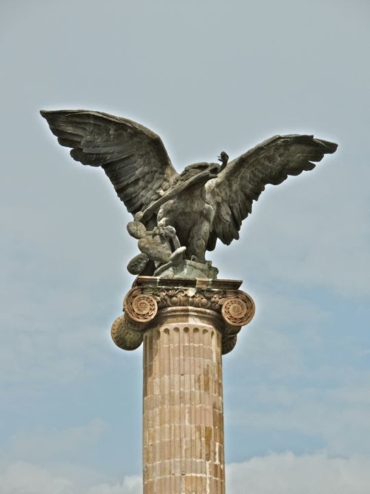
An eagle, eating a snake while sitting on a nopal cactus, surmounts the Exedra Column. This is the symbol of the nation of Mexico, and was not originally part of the column. Tolsa's work was completed just before the 1810 outbreak of the Mexican War of Independence from Spain. The column was intended to honor King Carlos IV. By the time it was finished, Carlos had died and his son Fernando VII had just ascended the throne. Therefore, a statue of Fernando topped the column when it was unveiled in 1808. Fernando's statue lasted only until the insurgent victory in 1821, when it was knocked down by the exuberant rebels. In 1949, a new column was built by architect Roberto Alvarez Espinoza, and in 1986 the eagle and snake were added at the top. The 1949 column and its amphitheatre were built with pink cantera stone and follow Tolsa's Neoclassical style, if not his political imagery. Tolsa died in 1816, so he never saw the destruction of his original work.


A crescent pool fed by vertical jets of water surrounds the back side of the Exedra monument. Buried in the base of the monument are the remains of Governor José Maria Chavez. He was a liberal hero executed by the French in 1864 during their five-year occupation of Mexico. Another hero, cultural rather than political or military, is honoured by the gold metal statue you see in the center-right of the photo. Manuel Ponce (1882-1948) was a composer of chamber and orchestral music. His works were heavily influenced by traditional Mexican songs. This scandalised the upper class during the Porfirio Diaz dictatorship because they were slavish in their addiction to European culture. However, it fit well with the revolutionary feeling of the post-Diaz era which sought to reconnect with Mexico's roots. One of the things I appreciate about Mexico is how the country honours its artists, musicians, writers, and great educators. Statues and other monuments to them fill parks and plazas all over the nation.


Sign of the times. Sitting on a bench near monuments to 19th Century heroes, a young father fiddles with his 21st Century electronic device. His wife watches skeptically, while his young son looks on, apparently disgusted that he is not the focus of all that attention. With a beautifully preserved historical center, Aguascalientes is one of the most modern, clean, and prosperous cities in Mexico.  It has always occupied a geographically advantageous position in the centre of the country. Since early colonial times silver shipments from Zacatecas passed through from the north. Commercial goods, in turn, moved up from from Guadalajara to the south. Aguascalientes has been further blessed with rich agricultural lands all around it. When the great railroad networks were built in the last quarter of the 19th Century, the city became a major hub, further increasing its importance and wealth. The people we saw seemed well dressed and prosperous, with cell phones and iPads and all the other accoutrements of modern life.


Another of the Exedra Column's fountains overlooks the Palacio del Gobierno. In addition to the jets in the pool behind the Exedra Column, there are two traditional fountains like the one above and in the first photo of this posting. In the background, the two-story Palacio del Gobierno (Government Palace) occupies half of the south side of the Plaza de la Patria. Once a colonial mansion, the Palacio  later became a government building.


The Government Palace

Palacio del Gobierno is the seat of the state government of Aguascalientes. A nun approaches across the wide Plaza from the direction of the Palacio del Gobierno (Palace of the Government). Along with the Palacio del Municipio (the municipal building) to its left, the Palacio del Gobierno forms the south side of the Plaza. The only side of the Plaza which is bordered by a street is to the north. This traffic-free zone avoids the noise, hazards, and air pollution found at plazas surrounded by auto-clogged streets. The Palacio del Gobierno was built in the 1660s as a mansion for the local bishop and is a fine example of late 17th Century colonial architecture. Prior to our visit to Auguascalientes, I consulted Richard Perry's website "Exploring Colonial Mexico." Much of my information about the architecture of the Palacio del Gobierno and the Cathedral comes from his website. I strongly recommend it to anyone visiting Mexico's old colonial cities and towns.


Five balconies adorn the front of the upper floor of the Palacio. Each is framed with elaborately carved limestone called chiluca. Another name often used for this stone is cantera. Above each doorway is the coat-of-arms of a wealthy family named Rincon Gallardo who owned the property for a period after it passed out of the hands of the Church. The rough reddish stone of the walls surrounding the windows and doors is called tezontle and is of volcanic origin.


The interior of the Palacio is a forest of columns surrounding a unique staircase. The staircase is in the shape of a cross. Steps lead up from the north and south and meet at a landing in the middle. From that landing, two other staircases lead up toward the east and west to the second floor. The east and west sides of the first floor are passageways formed by columns and arches called portales. The north and south stairways drop down into broad, tiled courtyards. The columns and courtyards manage to convey the impression of both openness and boundaries. Following the Rincon Gallardo period of ownership, the building became an inn. Then, in 1856, it became Aguascalientes' town hall, but later was taken over by the state government for its headquarters.


View from the second floor to the south courtyard. Many of the walls behind the portals are covered with large murals depicting dramatic scenes from Mexico's history. They were beautifully painted by Chilean artist Oswaldo Barra, a disciple of the great muralist Diego Rivera. In a future posting, I will walk you through the Palacio and show a few of the mural panels. Their effect on the viewer is intense. The scenes are thickly peopled and overlapping. Depictions of great peace and beauty are interwoven with other scenes showing the violence that has typified much of the drama and tragedy of Mexico's long history.

The Municipal building

The Palacio del Municipio is just east of the Palacio del Gobierno. Municipal governments are not just city governments as they are in the United States. A municipio is actually more like a US county. Municipios are typically composed of rural land and various towns and villages. The largest town or city in the municipio is the seat of government and almost invariably possesses the same name as the municipio itself. Aguascalientes is therefore not only the name of the city, and the state, but also of the municipio. Like much else in Mexico, this can be a bit confusing for newcomers
.

The courtyard of the Palacio del Municipio contains a fountain and a broad, double-staircase. The 100 meter (100 yd) wide property on which the building sits was originally given to Martín Fernández de Baulús and Gaspar de Aguilar as a merced (land grant from the Spanish crown) during the first part of the 17th Century. In 1665, after passing through several hands, the property was acquired by the Alcalde (Mayor) Don Juan Rincón de Vivar,  and the parish priest Don Pedro Rincón de Ortega, who also owned the great Hacienda Cienega de Mata outside the city. The two eventually decided to use as the site for a city hall. The building was constructed in 1700 and is of the Neo-classic style that was just becoming popular in Mexico.


A large and brilliantly coloured mural stands between the two great staircases. As is usual with Mexican murals, there is a lot going on in this one. The centre of the mural is the Exedra column, and the steeple of the Cathedral is on the upper left. The mural gives a feeling of looking up from the centre of the courtyard toward the sky. It is populated by a variety of figures, including folkloric dancers, charros (Mexican rodeo horsemen) in broad sombreros, factory workers, and many others. One can stand in front of a mural like this for a long time and still not absorb everything.


Carole stands between two of the great pillars that guard the front of the Palacio del Municipio. In the distance, one of the bell towers of the Cathedral rises toward the sky. Vendors have set up their stalls in the middle of the Plaza in anticipation of the fiesta for the Virgin of the Assumption (August 16-20).


The Cathedral

The Cathedral, viewed from in front of the Palacio del Gobierno. The church is known as the Catedral de Nuestra Señor de la Asunción (Cathdral of Our Lady of the Assumption). The property had originally been occupied by two chapels built in 1575 and 1605, respectively. In 1704, the priest Antonio Flores Acevedo started construction on the present church, but it was not until 1738 that his successor Manuel Colon de Larreategui finished the main building. Even so, the northern (right) tower was not completed until 1764 and the one on the south took until 1946. When Pope Leon XIII established a diocese in Aguascalientes in 1889, the church officially became a Cathedral.


Detail of one of the carved wooden panels of the Cathedral's great entrance door. In 1744, colonial architects Felipe de Ureña and Juan Garica de Casteñada built some wonderful retablos in the interior. Unfortunately, these have been lost during Mexico's subsequent turbulent history. In a future posting, we will take a much closer look at the Cathedral and its interior furnishings.


Random encounters around the Plaza

A narrow pedestrian street runs in front of the Quality Inn and ends at the Plaza. We stayed at the Quality during our brief stop over at Aguascalientes. A very modern and well-run hotel, it occupies the southwest corner of the Plaza. Importantly for a car-clogged city, it provides free off-street parking in its underground garage. Above, Carole strolls along the street, headed out on another adventure. Although you can see two cars parked on the left, this was only for loading/unloading purposes. The entrance to the hotel is under the flags on the left side of the photo.


The fiesta of the Virgin of the Assumption was in full sway during our visit. Looking out our hotel window, I saw this religious parade passing along the street seen in the previous photo. The procession was headed toward the Plaza and the Cathedral.


Indigenous dancers in colourful costumes formed part of the procession. The one on the left appears to be carrying a small bow and arrow in his left hand. It took only two years for the Spanish to conquer the powerful and civilised Aztecs to the south, but it took more than fifty to pacify the wild tribes who inhabited the Aguascalientes area. In fact, the Chichimecs, as the uncivilised, nomadic tribes of the north were generically known, had plagued every pre-hispanic civilisation for the previous 2000 years. The Aztecs themselves were a former Chichimec tribe who came south in a two-century migration that finally ended when they reached Tenochtitlán (modern Mexico City).


A musician set up shop just outside the front door of our hotel.  He was really quite good, at least to my unpracticed ear, so I made sure to drop some money in his horn case. One of the benefits of living in Mexico is that your life has a musical soundtrack. Everywhere you go there are musicians playing a variety of instruments. It's a hard way to make a living, so I try to be generous.


Sanborn's can be found on the northeast corner of the Plaza. Sanborn's is a chain of store/restaurants that has been a Mexican institution since 1903 but can also be found in El Salvador and Panama. The company was started by the brothers Walter and Frank Sanborn, Americans from California. At a location across from the main post office in Mexico City, they set up a lunch counter and soda fountain, the first of their kind in Mexico, The original Sanborn's is still in operation. The one above shares quarters with Hotel Francia, which was built in the French style in 1915


A double-decker tourist bus was parked in front of the Palacio Legislativo. The State Legislature building is located on the north side of the plaza, the only one bordered by a street. While we have ridden buses like this one in other cities, we passed on this one. Typically, the loudspeakers blare more loudly than I like, and virtually always in Spanish since most of the tourists are Mexican. Since the Centro Historico is fairly compact, and we had such a short time available, we felt it best to see the sights on foot. The tourist buses are not a bad option, and can even be fun, if you have the time and don't mind the blaring loudspeakers.


A croc to keep an eye on things. We encountered this fellow on the wall of a restaurant just off the Plaza on our first night. He was one of a number of critters mounted on the walls, including a rather bellicose looking hippopotamus. He was just another example of the quirky sense of humor you find everywhere in Mexico.

This completes Part 1 of my series on Aguascalientes. If you enjoyed it, I hope you will take the time to leave your thoughts in the Comments section below, or email me directly. If it says "no comments" it means no one has commented before you. Just click on that and it will take you to the place where you can leave your remarks or questions.

If you leave a question in the Comments section, PLEASE leave your email address so I can repond.

Hasta luego, Jim

Wednesday, April 2, 2014

Getting high on Tequila (Part 2)

A massive stone dome rises in the caldera of Volcan Tequila. This is a lava plug, the remains of the lava which congealed in the tube of the volcano. The surrounding material eventually eroded away, leaving a huge vertical monument to remind us of the volcano's ancient fury. What you see above is only about the top 1/3 of the plug. In the last posting (Part 1) we hiked up to the caldera rim, and then down inside it to the base of the plug. This posting will give you a feel for our climb around the base of the plug, and our return by a different, more difficult route than the one we used on our ascent.


Gary (left) and Jim B (right) pick their way carefully along a cliff face. It is a good idea to watch your step while hiking, but it is especially true up here where volcanic rock is rough and often jagged. It is at such times that a hiking stick is vital for testing the stability of rocks and acting as a third point of balance.


The face of the lava plug is very sheer. This telephoto shot only captures the top few feet of the face. The drop extends below it for several hundred vertical feet. The top and parts of the sides of the plug are covered with trees and other vegetation, in spite of the fact that there is very little soil. Life finds a way.


Kathy watches while one of the other hikers ascends a rock face. Kathy is one of the strongest hikers I know. Despite her petite size, she has tremendous stamina and can hold her own with any of the male hikers. She was part of a recent expedition by some of my hiking friends into the roadless jungles of northern Guatemala. It was a two-day slog (each way) through ankle-deep mud and extensive swamps. For 10 hours at a stretch, they followed the mule train that carries supplies to the remote archaeological dig at El Mirador.


Jim B tries his luck with a rock promontory adjacent to the lava plug. It was a tall jumble of broken boulders with trees growing out of the cracks. Getting around the trees was almost as much of a challenge as climbing up the boulders themselves. Jim B is within a few months of my age (66) and is in top shape. When he is not hiking steep mountain trails twice a week, he bicycles long distance. During his off-time, he goes to the gym. He organised the Guatemala trip.


Clambering the last few feet to the top, Jim grips the trunk of a dead tree. The climb didn't require technical gear or ropes, but was still risky. A fall, a twisted ankle, or a deep gash from a sharp rock would have created a real problem in terms of getting him down the mountain to our parked cars.


He made it! Jim triumphantly poses at the crest of the promontory. Now all he has to do is get back down again. This is no small task, because a climb down is always trickier than one going up. Most people who get hurt do so coming down.


Jim at the peak, a different perspective. Here you can get a sense of scale. From where I took this photo, the promontory is probably 40-50 feet high. However, it drops off at least 100 vertical feet to the right.


The return hike

Peter (left) and Kathy gingerly pick their way down from the base of the plug. After Jim B's safe return, we decided it was time to head back. We would be returning to our cars by way of the 2nd set of communication towers. They are located on the far side of the caldera rim from the towers seen in Part 1, and are separated from them by the yawning mouth of the volcano.


View of the back side of the lava plug. This side is every bit as rugged and vertical as the front side, although the drop from crest to base is not quite so far.


Kathy, Gary, and Jim B traverse the steep, grassy slope inside the caldera's rim.  In most places along here, the trail was less than a foot wide, and sometimes the drifts of oak leaves make it very indistinct. To the left, the slope continues steeply down hundreds of feet into the throat of the caldera.


Kathy and Ralph (left) approach the bottom of a cliff as Gary and Jim B begin their descent. The rough rock provided many hand and footholds, making it safer to climb down than if it was smooth. Still, losing your balance on a spot like this could be like sliding down a cheese grater.


Clumps of these Cirsium thistles grow all over the rim of the volcano. They are large, about the size of a baseball, and their flowers glowed a brilliant red in the sunshine.


Running out of trail, we spread out over the hillside, each picking our own way. This was one of the more difficult spots. Although there was little danger, it was physically more strenuous than the rock climbing. We fought our way up the steep slope through loose rocks and deep, slippery piles of oak leaves. Sometimes it was two steps forward and one back. At 9000+ feet, I found myself quickly tiring.


A view up the slope we were climbing. Up and up we climbed, with the crest never seeming to get any closer. The air was thin and I was panting heavily and needed to stop frequently to catch my breath. I did notice that Peter and Gary seemed happy to stop whenever I paused.


Peter, at the top of the ridge. He is from the Netherlands. Peter is physically tough and wiry, but he looked as bushed as I felt when we finally got to the rim of the caldera.


View of the first set of communication towers from across the caldera. The second set of towers is outside the frame of the photo to the left. The mountains of northern Jalisco and Nayarit loom in the background. The rim of the caldera curves around in the shape of a giant "U". The open side was created when the volcano exploded out toward the southeast tens of thousands of years ago.


Gary catches his breath on the rim of the caldera before the last push to the towers. He is a big, friendly, bear of a guy. Originally (and unmistakably) from New York, he spent the last part of his working life as a quality control manager at a large bakery company. After moving to Mexico about a year ago, he met his Mexican girlfriend Marina and they moved in together. Gary seems as happy as a bear that has found a big jar of honey.


The view out the open side of the "U" on the caldera's southeast side. The sheer wall to the right is the front of the lava plug, The wooded slope to the left is the rim of the caldera. An uneven checkerboard of cultivated fields spreads out across the valley far below. Most of the green fields you see are rows of agave cultivated by the tequila industry.


View from the valley southeast of the volcano, looking back up at the lava plug. The late afternoon shadows gather in the folds of the mountain as golden light slants across fertile fields. The position from which I took this photo looks almost directly back at the place where I stood to take the previous shot. We had stopped by the highway on our way home so I could get some final shots of the whole mountain. This is a beautiful area, well worth the two hours it took to reach it.

This completes Part 2 of my two-part series on our hike inside caldera of the Volcan Tequila. I hope you enjoyed it and got a good sense of the mountain and the area around it. I always welcome feedback and questions. If you have any, please leave them in the Comments section below, or email me directly. If no one else has commented yet, it may say "No Comments". Just click on that and the Comments page will open.

If you leave a question in the Comments section, PLEASE leave your email address so I can respond.

Hasta luego, Jim