This fountain is one of several at Plaza de la Patria in Aguacalientes' Centro Historico. The air is cool and moist around the dripping fountain near the Exedra Column. This makes it a perfect spot to pause on a hot day. Some of our friends had advised us that Aguascalientes is a city worth skipping because, in their view, it contains little of interest. Perhaps this attitude reflects the fact that the city is surrounded by several high-speed circumferential highways, giving it a "bullseye" appearance on a map and making the old city center easy to bypass. On a previous trip to Zacatecas, using one of these bypass roads, all we saw of Aguascalientes were modern industrial complexes and new suburban developments. This seemed to confirm the opinions of our friends. However, in the summer of 2013, we planned a trip to San Luis Potosi and decided to break the journey with an overnight stop along the way. A little Google research about Aguascalientes piqued our interest in its
Centro Historico. The city is only about four hours' drive north from our home at Lake Chapala, so we arrived about mid-day. We left again the next day, also about noon. During this 24 hour period, I managed to take more than 400 photos! Our experience showed us that our friends could not have been more wrong. For a Google map to locate Aguascalientes in relation to Guadalajara and Lake Chapala,
click here.
The Exedra Column and its park
The Exedra Column, and the park in its rear, occupy the eastern side of the Plaza de la Patria. The Plaza was laid out in 1609 and is 84 meters (275.6 ft) on a side. It is bounded by the Exedra monument and park on the east, the Cathedral on the west, the
Palacio del Gobierno on the south, and colonial mansions (now commercial buildings) on the north. The Exedra Column, and the curved amphitheatre surrounding it, dominate the plaza. The original column was built in 1808 by architect and sculptor
Manuel Tolsa. Born and raised in 18th Century Spain, he came to the Viceroyalty of New Spain (Mexico) in 1791 to head the sculpture department of the Academy of New Spain. He was committed to the Neoclassical style and led the move away from the prevailing Baroque style of New Spain. He is responsible for many famous architectural works in Mexico, including the final form of the great Cathedral in Mexico City.
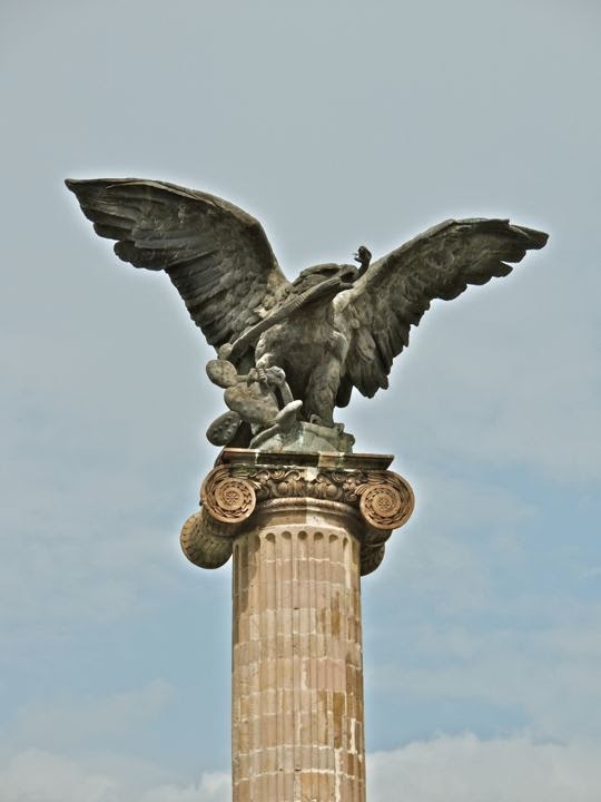
An eagle, eating a snake while sitting on a nopal cactus, surmounts the Exedra Column. This is the symbol of the nation of Mexico, and was not originally part of the column.
Tolsa's work was completed just before the 1810 outbreak of the Mexican War of Independence from Spain. The column was intended to honor King Carlos IV. By the time it was finished, Carlos had died and his son Fernando VII had just ascended the throne. Therefore, a statue of Fernando topped the column when it was unveiled in 1808. Fernando's statue lasted only until the insurgent victory in 1821, when it was knocked down by the exuberant rebels. In 1949, a new column was built by architect Roberto Alvarez Espinoza, and in 1986 the eagle and snake were added at the top. The 1949 column and its amphitheatre were built with pink cantera stone and follow Tolsa's Neoclassical style, if not his political imagery. Tolsa died in 1816, so he never saw the destruction of his original work.
A crescent pool fed by vertical jets of water surrounds the back side of the Exedra monument. Buried in the base of the monument are the remains of Governor José Maria Chavez. He was a liberal hero executed by the French in 1864 during their five-year occupation of Mexico. Another hero, cultural rather than political or military, is honoured by the gold metal statue you see in the center-right of the photo.
Manuel Ponce (1882-1948) was a composer of chamber and orchestral music. His works were heavily influenced by traditional Mexican songs. This scandalised the upper class during the Porfirio Diaz dictatorship because they were slavish in their addiction to European culture. However, it fit well with the revolutionary feeling of the post-Diaz era which sought to reconnect with Mexico's roots. One of the things I appreciate about Mexico is how the country honours its artists, musicians, writers, and great educators. Statues and other monuments to them fill parks and plazas all over the nation.
Sign of the times. Sitting on a bench near monuments to 19th Century heroes, a young father fiddles with his 21st Century electronic device. His wife watches skeptically, while his young son looks on, apparently disgusted that
he is not the focus of all that attention. With a beautifully preserved historical center, Aguascalientes is one of the most modern, clean, and prosperous cities in Mexico. It has always occupied a geographically advantageous position in the centre of the country. Since early colonial times silver shipments from Zacatecas passed through from the north. Commercial goods, in turn, moved up from from Guadalajara to the south. Aguascalientes has been further blessed with rich agricultural lands all around it. When the great railroad networks were built in the last quarter of the 19th Century, the city became a major hub, further increasing its importance and wealth. The people we saw seemed well dressed and prosperous, with cell phones and iPads and all the other accoutrements of modern life.
Another of the Exedra Column's fountains overlooks the Palacio del Gobierno. In addition to the jets in the pool behind the Exedra Column, there are two traditional fountains like the one above and in the first photo of this posting. In the background, the two-story
Palacio del Gobierno (Government Palace) occupies half of the south side of the
Plaza de la Patria. Once a colonial mansion, the
Palacio later became a government building.
The Government Palace
Palacio del Gobierno is the seat of the state government of Aguascalientes. A nun approaches across the wide Plaza from the direction of the
Palacio del Gobierno (Palace of the Government). Along with the
Palacio del Municipio (the municipal building) to its left, the
Palacio del Gobierno forms the south side of the Plaza. The only side of the Plaza which is bordered by a street is to the north. This traffic-free zone avoids the noise, hazards, and air pollution found at plazas surrounded by auto-clogged streets. The
Palacio del Gobierno was built in the 1660s as a mansion for the local bishop and is a fine example of late 17th Century colonial architecture. Prior to our visit to Auguascalientes, I consulted Richard Perry's website
"Exploring Colonial Mexico." Much of my information about the architecture of the
Palacio del Gobierno and the Cathedral comes from his website. I strongly recommend it to anyone visiting Mexico's old colonial cities and towns.
Five balconies adorn the front of the upper floor of the Palacio. Each is framed with elaborately carved limestone called
chiluca. Another name often used for this stone is
cantera. Above each doorway is the coat-of-arms of a wealthy family named Rincon Gallardo who owned the property for a period after it passed out of the hands of the Church. The rough reddish stone of the walls surrounding the windows and doors is called
tezontle and is of volcanic origin.
The interior of the Palacio is a forest of columns surrounding a unique staircase. The staircase is in the shape of a cross. Steps lead up from the north and south and meet at a landing in the middle. From that landing, two other staircases lead up toward the east and west to the second floor. The east and west sides of the first floor are passageways formed by columns and arches called
portales. The north and south stairways drop down into broad, tiled courtyards. The columns and courtyards manage to convey the impression of both openness and boundaries. Following the Rincon Gallardo period of ownership, the building became an inn. Then, in 1856, it became Aguascalientes' town hall, but later was taken over by the state government for its headquarters.
View from the second floor to the south courtyard. Many of the walls behind the portals are covered with large murals depicting dramatic scenes from Mexico's history. They were beautifully painted by Chilean artist Oswaldo Barra, a disciple of the great muralist Diego Rivera. In a future posting, I will walk you through the
Palacio and show a few of the mural panels. Their effect on the viewer is intense. The scenes are thickly peopled and overlapping. Depictions of great peace and beauty are interwoven with other scenes showing the violence that has typified much of the drama and tragedy of Mexico's long history.
The Municipal building
The Palacio del Municipio is just east of the Palacio del Gobierno. Municipal governments are not just city governments as they are in the United States. A
municipio is actually more like a US county.
Municipios are typically composed of rural land and various towns and villages. The largest town or city in the
municipio is the seat of government and almost invariably possesses the same name as the
municipio itself. Aguascalientes is therefore not only the name of the city, and the state, but also of the
municipio. Like much else in Mexico, this can be a bit confusing for newcomers
.
The courtyard of the Palacio del Municipio contains a fountain and a broad, double-staircase. The 100 meter (100 yd) wide property on which the building sits was originally given to Martín Fernández de Baulús and Gaspar de Aguilar as a
merced (land grant from the Spanish crown) during the first part of the 17th Century. In 1665, after passing through several hands, the property was acquired by the Alcalde (Mayor) Don Juan Rincón de Vivar, and the parish priest Don Pedro Rincón de Ortega, who also owned the great
Hacienda Cienega de Mata outside the city. The two eventually decided to use as the site for a city hall. The building was
constructed in 1700 and is of the Neo-classic style that was just becoming popular in Mexico.
A large and brilliantly coloured mural stands between the two great staircases. As is usual with Mexican murals, there is a lot going on in this one. The centre of the mural is the Exedra column, and the steeple of the Cathedral is on the upper left. The mural gives a feeling of looking up from the centre of the courtyard toward the sky. It is populated by a variety of figures, including folkloric dancers,
charros (Mexican rodeo horsemen) in broad sombreros, factory workers, and many others. One can stand in front of a mural like this for a long time and still not absorb everything.
Carole stands between two of the great pillars that guard the front of the Palacio del Municipio. In the distance, one of the bell towers of the Cathedral rises toward the sky. Vendors have set up their stalls in the middle of the Plaza in anticipation of the fiesta for the Virgin of the Assumption (August 16-20).
The Cathedral
The Cathedral, viewed from in front of the Palacio del Gobierno. The church is known as the
Catedral de Nuestra Señor de la Asunción (Cathdral of Our Lady of the Assumption). The property had originally been occupied by two chapels built in 1575 and 1605, respectively. In 1704, the priest Antonio Flores Acevedo started construction on the present church, but it was not until 1738 that his successor Manuel Colon de Larreategui finished the main building. Even so, the northern (right) tower was not completed until 1764 and the one on the south took until 1946. When Pope Leon XIII established a diocese in Aguascalientes in 1889, the church officially became a Cathedral.
Detail of one of the carved wooden panels of the Cathedral's great entrance door. In 1744, colonial architects Felipe de Ureña and Juan Garica de Casteñada built some wonderful retablos in the interior. Unfortunately, these have been lost during Mexico's subsequent turbulent history. In a future posting, we will take a much closer look at the Cathedral and its interior furnishings.
Random encounters around the Plaza
A narrow pedestrian street runs in front of the Quality Inn and ends at the Plaza. We stayed at the Quality during our brief stop over at Aguascalientes. A very modern and well-run hotel, it occupies the southwest corner of the Plaza. Importantly for a car-clogged city, it provides free off-street parking in its underground garage. Above, Carole strolls along the street, headed out on another adventure. Although you can see two cars parked on the left, this was only for loading/unloading purposes. The entrance to the hotel is under the flags on the left side of the photo.
The fiesta of the Virgin of the Assumption was in full sway during our visit. Looking out our hotel window, I saw this religious parade passing along the street seen in the previous photo. The procession was headed toward the Plaza and the Cathedral.
Indigenous dancers in colourful costumes formed part of the procession. The one on the left appears to be carrying a small bow and arrow in his left hand. It took only two years for the Spanish to conquer the powerful and civilised Aztecs to the south, but it took more than fifty to pacify the wild tribes who inhabited the Aguascalientes area. In fact, the
Chichimecs, as the uncivilised, nomadic tribes of the north were generically known, had plagued every pre-hispanic civilisation for the previous 2000 years. The Aztecs themselves were a former Chichimec tribe who came south in a two-century migration that finally ended when they reached
Tenochtitlán (modern Mexico City).
A musician set up shop just outside the front door of our hotel. He was really quite good, at least to my unpracticed ear, so I made sure to drop some money in his horn case. One of the benefits of living in Mexico is that your life has a musical soundtrack. Everywhere you go there are musicians playing a variety of instruments. It's a hard way to make a living, so I try to be generous.
Sanborn's can be found on the northeast corner of the Plaza. Sanborn's is a chain of store/restaurants that has been a Mexican institution since 1903 but can also be found in El Salvador and Panama. The company was started by the brothers Walter and Frank Sanborn, Americans from California. At a location across from the main post office in Mexico City, they set up a lunch counter and soda fountain, the first of their kind in Mexico, The original Sanborn's is still in operation. The one above shares quarters with Hotel Francia, which was built in the French style in 1915
A double-decker tourist bus was parked in front of the Palacio Legislativo. The State Legislature building is located on the north side of the plaza, the only one bordered by a street. While we have ridden buses like this one in other cities, we passed on this one. Typically, the loudspeakers blare more loudly than I like, and virtually always in Spanish since most of the tourists are Mexican. Since the Centro Historico is fairly compact, and we had such a short time available, we felt it best to see the sights on foot. The tourist buses are not a bad option, and can even be fun, if you have the time and don't mind the blaring loudspeakers.
A croc to keep an eye on things. We encountered this fellow on the wall of a restaurant just off the Plaza on our first night. He was one of a number of critters mounted on the walls, including a rather bellicose looking hippopotamus. He was just another example of the quirky sense of humor you find everywhere in Mexico.
This completes Part 1 of my series on Aguascalientes. If you enjoyed it, I hope you will take the time to leave your thoughts in the Comments section below, or email me directly. If it says "no comments" it means no one has commented before you. Just click on that and it will take you to the place where you can leave your remarks or questions.
If you leave a question in the Comments section, PLEASE leave your email address so I can repond.
Hasta luego, Jim